Bridge Statistics for Millville, New Jersey (NJ)
Condition, Traffic, Stress, Structural Evaluation, Project Costs
- National Bridge Inventory (NBI) Statistics
- 32Number of bridges
- 253ft / 77.3mTotal length
- $24,856,000Total costs
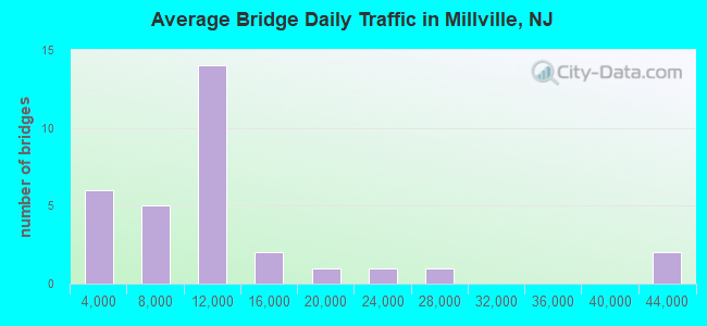
- 359,410Total average daily traffic
- 16,263Total average daily truck traffic
- National Bridge Inventory (NBI) Registered Bridges for Millville
- No street view available for this location
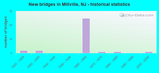
- New bridges - historical statistics
- 21920-1929
- 21930-1939
- 251960-1969
- 11970-1979
- 11980-1989
- 12000-2009
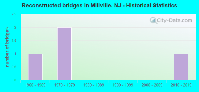
- Reconstructed bridges - Historical Statistics
- 11960-1969
- 21970-1979
- 01980-1989
- 01990-1999
- 02000-2009
- 12010-2019
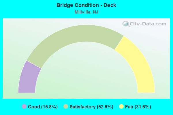
- Bridge Condition - Deck
- 15.8%Good
- 52.6%Satisfactory
- 31.6%Fair
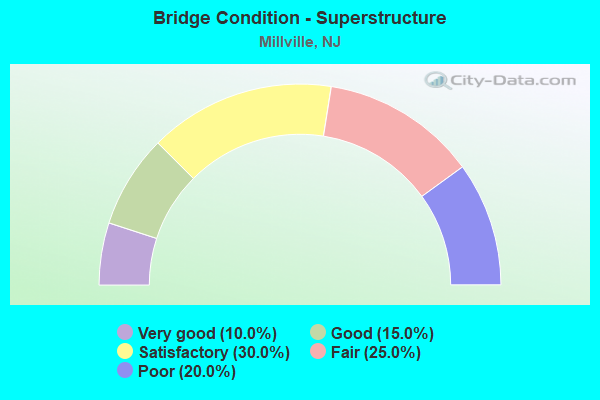
- Bridge Condition - Superstructure
- 10.0%Very good
- 15.0%Good
- 30.0%Satisfactory
- 25.0%Fair
- 20.0%Poor
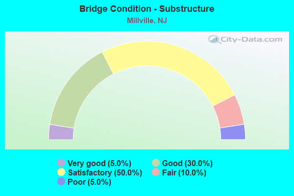
- Bridge Condition - Substructure
- 5.0%Very good
- 30.0%Good
- 50.0%Satisfactory
- 10.0%Fair
- 5.0%Poor
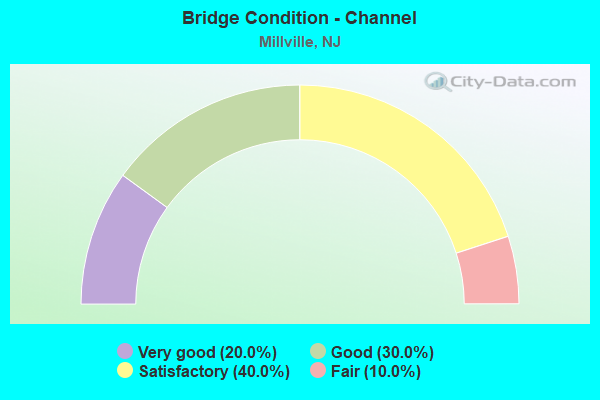
- Bridge Condition - Channel
- 20.0%Very good
- 30.0%Good
- 40.0%Satisfactory
- 10.0%Fair
Find on map >> Show street view
Structure Number: 600009, Location: 0.25 M N OF RT 49 (Lat: 39.398061, Lng: -75.043061), Route carried "on" structure: City street , Year Built: 1961, Status: Open, Structure Length: 5.03m (16.50ft), Average Daily Traffic: 4,825 (year 2020), Truck Traffic: 4%, Average Future Daily Traffic: 5,888 (year 2040), Design Load: HS 20, Features Intersected: MAURICE RIVER, Facility Carried by Structure: BRANDRIFF AVE
Minimum Vertical Clearance: 30+ m (98+ ft), Kilometerpoint: 0.338, Lanes on structure: 2, Owner: County Highway Agency, Approaching Roadway Width: 10.1m (33.1ft), Navigation Control: Yes ( Vertical Clearance: 3.0m (9.8ft), Horizontal Clearance: 15.5m (50.9ft)), Material/Design: Prestressed concrete, Design/Construction: Stringer/Multi-beam, Number Of Spans In Main Unit: 3, Length of Maximum Span: 16.5m (54.1ft), Curb or Sidewalk Widths: Left: 0.8m (2.6ft), Right: 1.7m (5.6ft), Curb-To-Curb Width: 10.0m (32.8ft), Out-to-Out Width: 13.2m (43.3ft)
Condition: Deck: Satisfactory, Superstructure: Good, Substructure: Satisfactory, Channel: Good, Operating Rating: 39.9 metric tons, Method Used To Determine Operating Rating: Load Factor (LF), Inventory Rating: 23.6 metric tons, Method Used To Determine Inventory Rating: Load Factor (LF), Structural Evaluation: Equal to present minimum criteria, Deck Geometry: Meets minimum limits, Waterway Adequacy: Superior to present desirable criteria, Approach Roadway Alignment: Better than present minimum criteria, Designated Inspection Frequency: Every 24 months, Underwater Inspection Frequency: Every 48 months, Inspection Date: July 2020, Underwater Inspection Date: September 2020, Deck Structure Type: Concrete Cast-file-Place, Wearing Surface/Protective System: Wearing Surface: Monolithic Concrete
Find on map >> Show street view
Structure Number: 60001, Location: 0.6 MI NORTH OF RTE 49 (Lat: 39.403139, Lng: -75.049481), Route carried "on" structure: County highway 667, Year Built: 1987, Status: Open, Structure Length: 0.76m (2.49ft), Average Daily Traffic: 11,972 (year 2020), Truck Traffic: 4%, Average Future Daily Traffic: 14,608 (year 2040), Features Intersected: UNION LAKE DAM RACEWAY, Facility Carried by Structure: SHARP ST
Minimum Vertical Clearance: 30+ m (98+ ft), Kilometerpoint: 0.901, Lanes on structure: 2, Owner: County Highway Agency, Approaching Roadway Width: 11.9m (39.0ft), Material/Design: Concrete, Design/Construction: Culvert, Number Of Spans In Main Unit: 2, Length of Maximum Span: 3.7m (12.1ft), Curb or Sidewalk Widths: Left: 1.6m (5.2ft), Right: 1.5m (4.9ft), Curb-To-Curb Width: 11.9m (39.0ft), Out-to-Out Width: 15.7m (51.5ft)
Condition: Channel: Good, Culverts: Good, Operating Rating: 44.5 metric tons, Method Used To Determine Operating Rating: Load Factor (LF), Inventory Rating: 26.3 metric tons, Method Used To Determine Inventory Rating: Load Factor (LF), Structural Evaluation: Equal to present minimum criteria, Deck Geometry: Somewhat better than minimum adequacy, Waterway Adequacy: Superior to present desirable criteria, Approach Roadway Alignment: Equal to present minimum criteria, Designated Inspection Frequency: Every 24 months, Inspection Date: August 2020, Deck Structure Type: Concrete Cast-file-Place, Wearing Surface/Protective System: Wearing Surface: Bituminous, Membrane: Preformed Fabric, Deck Protection: Epoxy Coated Reinforcing
Find on map >> Show street view
Structure Number: 600015, Location: 3 M SE OF RT 555&670 INT (Lat: 39.332381, Lng: -75.019661), Route carried "on" structure: County highway 670, Year Built: 2007, Status: Open, Structure Length: 2.74m (8.99ft), Average Daily Traffic: 6,543 (year 2020), Truck Traffic: 4%, Average Future Daily Traffic: 7,984 (year 2040), Features Intersected: LAUREL LAKE
Minimum Vertical Clearance: 30+ m (98+ ft), Kilometerpoint: 21.404, Lanes on structure: 2, Owner: County Highway Agency, Approaching Roadway Width: 14.0m (45.9ft), Material/Design: Prestressed concrete, Design/Construction: Box Beam or Girders - Multiple, Number Of Spans In Main Unit: 1, Length of Maximum Span: 25.9m (85.0ft), Curb or Sidewalk Widths: Left: 0.0m, Right: 1.8m (5.9ft), Curb-To-Curb Width: 12.2m (40.0ft), Out-to-Out Width: 14.9m (48.9ft)
Condition: Deck: Good, Superstructure: Very good, Substructure: Very good, Channel: Very good, Inventory Rating: 68.9 metric tons, Method Used To Determine Inventory Rating: Load Factor (LF), Structural Evaluation: Equal to present desirable criteria, Deck Geometry: Somewhat better than minimum adequacy, Waterway Adequacy: Better than present minimum criteria, Approach Roadway Alignment: Equal to present minimum criteria, Designated Inspection Frequency: Every 24 months, Inspection Date: August 2020, Deck Structure Type: Concrete Cast-file-Place, Wearing Surface/Protective System: Wearing Surface: Monolithic Concrete
Find on map >> Show street view
Structure Number: 600049, Location: 1.5M WEST OF RTE 55 (Lat: 39.438119, Lng: -75.107931), Route carried "on" structure: County highway 552, Year Built: 1936, Year Reconstructed: 1982, Status: Open, Structure Length: 0.79m (2.59ft), Average Daily Traffic: 13,362 (year 2020), Truck Traffic: 4%, Average Future Daily Traffic: 16,305 (year 2040), Features Intersected: LEBANON BR OF MILL CREEK
Minimum Vertical Clearance: 30+ m (98+ ft), Kilometerpoint: 10.895, Lanes on structure: 2, Owner: County Highway Agency, Approaching Roadway Width: 12.2m (40.0ft), Material/Design: Concrete, Design/Construction: Slab, Number Of Spans In Main Unit: 1, Length of Maximum Span: 4.9m (16.1ft), Curb-To-Curb Width: 12.6m (41.3ft), Out-to-Out Width: 12.9m (42.3ft)
Condition: Deck: Satisfactory, Superstructure: Satisfactory, Substructure: Satisfactory, Channel: Good, Operating Rating: 68.9 metric tons, Method Used To Determine Operating Rating: Load Factor (LF), Inventory Rating: 40.8 metric tons, Method Used To Determine Inventory Rating: Load Factor (LF), Structural Evaluation: Equal to present minimum criteria, Deck Geometry: Somewhat better than minimum adequacy, Waterway Adequacy: Equal to present minimum criteria, Approach Roadway Alignment: Equal to present desirable criteria, Designated Inspection Frequency: Every 24 months, Inspection Date: July 2020, Deck Structure Type: Concrete Cast-file-Place, Wearing Surface/Protective System: Wearing Surface: Bituminous
Find on map >> Show street view
Structure Number: 600054, Location: .2 MI N OF N J ROUTE 49 (Lat: 39.400339, Lng: -75.053519), Route carried "on" structure: County highway 667, Year Built: 1936, Year Reconstructed: 1978, Status: Open, Structure Length: 3.11m (10.20ft), Average Daily Traffic: 11,972 (year 2020), Truck Traffic: 4%, Average Future Daily Traffic: 14,608 (year 2040), Design Load: HS 20, Features Intersected: MAURICE RIVER
Minimum Vertical Clearance: 30+ m (98+ ft), Kilometerpoint: 0.418, Lanes on structure: 2, Owner: County Highway Agency, Approaching Roadway Width: 11.6m (38.1ft), Material/Design: Steel, Design/Construction: Stringer/Multi-beam, Number Of Spans In Main Unit: 4, Length of Maximum Span: 7.6m (24.9ft), Curb or Sidewalk Widths: Left: 0.7m (2.3ft), Right: 1.4m (4.6ft), Curb-To-Curb Width: 10.4m (34.1ft), Out-to-Out Width: 13.4m (44.0ft)
Condition: Deck: Good, Superstructure: Good, Substructure: Satisfactory, Channel: Very good, Operating Rating: 74.4 metric tons, Method Used To Determine Operating Rating: Load Factor (LF), Inventory Rating: 44.5 metric tons, Method Used To Determine Inventory Rating: Load Factor (LF), Structural Evaluation: Equal to present minimum criteria, Deck Geometry: Meets minimum limits, Waterway Adequacy: Superior to present desirable criteria, Approach Roadway Alignment: Equal to present desirable criteria, Designated Inspection Frequency: Every 24 months, Underwater Inspection Frequency: Every 48 months, Inspection Date: July 2020, Underwater Inspection Date: September 2018, Deck Structure Type: Concrete Cast-file-Place, Wearing Surface/Protective System: Wearing Surface: Monolithic Concrete, Deck Protection: Epoxy Coated Reinforcing
Find on map >> Show street view
Structure Number: 601152, Location: 1.0 MI N OF NJ 55&47 JUNC (Lat: 39.342739, Lng: -75.007139), Route carried "on" structure: State highway 47, Year Built: 1925, Year Reconstructed: 1960, Status: Open, Structure Length: 4.33m (14.21ft), Average Daily Traffic: 2,220 (year 2021), Truck Traffic: 4%, Average Future Daily Traffic: 2,710 (year 2041), Features Intersected: MANANTICO CREEK
Minimum Vertical Clearance: 30+ m (98+ ft), Kilometerpoint: 58.339, Lanes on structure: 2, Owner: State Highway Agency, Approaching Roadway Width: 9.4m (30.8ft), Navigation Control: Yes ( Vertical Clearance: 0.6m (2.0ft), Horizontal Clearance: 12.2m (40.0ft)), Material/Design: Steel continuous, Design/Construction: Girder and Floorbeam System, Number Of Spans In Main Unit: 2, Number Of Approach Spans: 1, Length of Maximum Span: 15.5m (50.9ft), Curb or Sidewalk Widths: Left: 0.2m (0.7ft), Right: 0.2m (0.7ft), Curb-To-Curb Width: 9.4m (30.8ft), Out-to-Out Width: 10.3m (33.8ft)
Condition: Deck: Fair, Superstructure: Poor, Substructure: Poor, Channel: Satisfactory, Operating Rating: 66.2 metric tons, Method Used To Determine Operating Rating: Load Factor (LF), Inventory Rating: 39.0 metric tons, Method Used To Determine Inventory Rating: Load Factor (LF), Structural Evaluation: Meets minimum limits, Deck Geometry: Meets minimum limits, Waterway Adequacy: Equal to present minimum criteria, Approach Roadway Alignment: Equal to present desirable criteria, Length Of Structure Improvement: 5.61m (18.41ft), Designated Inspection Frequency: Every 24 months, Critical Feature Inspection Frequency: Every 24 months, Underwater Inspection Frequency: Every 48 months, Inspection Date: July 2021, Critical Feature Inspection Date: July 2021, Underwater Inspection Date: June 2021, Bridge Improvement Cost: $3,967,000, Roadway Improvement Cost: $255,000, Total Project Cost: $5,266,000 ( Estimate for 2021), Deck Structure Type: Open Grating
Find on map >> Show street view
Structure Number: 605151, Location: .17 MILES WEST OF NJ 47 (Lat: 39.395281, Lng: -75.040389), Route carried "on" structure: State highway 49, Year Built: 1971, Status: Open, Structure Length: 4.08m (13.39ft), Average Daily Traffic: 21,145 (year 2021), Truck Traffic: 4%, Average Future Daily Traffic: 25,375 (year 2041), Design Load: HS 20, Features Intersected: MAURICE RIVER
Minimum Vertical Clearance: 30+ m (98+ ft), Kilometerpoint: 58.307, Lanes on structure: 3, Base Highway Network: Yes, Owner: State Highway Agency, Approaching Roadway Width: 15.2m (49.9ft), Skew: 1 degrees, Material/Design: Steel, Design/Construction: Stringer/Multi-beam, Number Of Spans In Main Unit: 2, Length of Maximum Span: 19.5m (64.0ft), Curb or Sidewalk Widths: Left: 2.4m (7.9ft), Right: 2.4m (7.9ft), Curb-To-Curb Width: 15.2m (49.9ft), Out-to-Out Width: 20.8m (68.2ft)
Condition: Deck: Satisfactory, Superstructure: Poor, Substructure: Satisfactory, Channel: Satisfactory, Operating Rating: 89.8 metric tons, Method Used To Determine Operating Rating: Load Factor (LF), Inventory Rating: 53.5 metric tons, Method Used To Determine Inventory Rating: Load Factor (LF), Structural Evaluation: Meets minimum limits, Deck Geometry: Equal to present minimum criteria, Waterway Adequacy: Equal to present desirable criteria, Approach Roadway Alignment: Equal to present desirable criteria, Length Of Structure Improvement: 5.06m (16.60ft), Designated Inspection Frequency: Every 24 months, Underwater Inspection Frequency: Every 48 months, Inspection Date: March 2021, Underwater Inspection Date: March 2019, Bridge Improvement Cost: $5,068,000, Roadway Improvement Cost: $507,000, Total Project Cost: $7,956,000 ( Estimate for 2021), Deck Structure Type: Concrete Cast-file-Place, Wearing Surface/Protective System: Wearing Surface: Monolithic Concrete
Find on map >> Show street view
Structure Number: 60615, Location: 1.2 MI EAST OF NJ 55 (Lat: 39.386400, Lng: -74.989281), Route carried "on" structure: State highway 49, Year Built: 1929, Status: Open, Structure Length: 0.70m (2.30ft), Average Daily Traffic: 7,850 (year 2021), Truck Traffic: 4%, Average Future Daily Traffic: 9,420 (year 2041), Design Load: HS 20, Features Intersected: MANANTICO CREEK
Minimum Vertical Clearance: 30+ m (98+ ft), Kilometerpoint: 62.893, Lanes on structure: 2, Owner: State Highway Agency, Approaching Roadway Width: 12.2m (40.0ft), Material/Design: Concrete, Design/Construction: Slab, Number Of Spans In Main Unit: 1, Length of Maximum Span: 6.4m (21.0ft), Curb-To-Curb Width: 12.2m (40.0ft), Out-to-Out Width: 17.9m (58.7ft)
Condition: Superstructure: Satisfactory, Substructure: Fair, Channel: Satisfactory, Operating Rating: 67.1 metric tons, Method Used To Determine Operating Rating: Load Factor (LF), Inventory Rating: 39.9 metric tons, Method Used To Determine Inventory Rating: Load Factor (LF), Structural Evaluation: Somewhat better than minimum adequacy, Deck Geometry: Somewhat better than minimum adequacy, Waterway Adequacy: Equal to present desirable criteria, Approach Roadway Alignment: Equal to present desirable criteria, Length Of Structure Improvement: 0.70m (2.30ft), Designated Inspection Frequency: Every 24 months, Underwater Inspection Frequency: Every 24 months, Inspection Date: April 2021, Underwater Inspection Date: April 2021, Bridge Improvement Cost: $251,000, Total Project Cost: $298,000 ( Estimate for 2019)
Find on map >> Show street view
Structure Number: 60915, Location: 3.1 MI S OF NJ 55 EXIT 24 (Lat: 39.348811, Lng: -74.998781), Route carried "on" structure: Other road , Year Built: 1966, Status: Open, Structure Length: 7.59m (24.90ft), Average Daily Traffic: 1,380 (year 2022), Truck Traffic: 3%, Average Future Daily Traffic: 1,656 (year 2042), Design Load: HS 20, Features Intersected: NJ ROUTE 55, Facility Carried by Structure: SCHOONER LANDNG RD
Minimum Vertical Clearance: 30+ m (98+ ft), Kilometerpoint: 0.000, Lanes on structure: 2, Lanes under structure: 4, Owner: State Highway Agency, Approaching Roadway Width: 9.1m (29.9ft), Skew: 3 degrees, Material/Design: Steel, Design/Construction: Stringer/Multi-beam, Number Of Spans In Main Unit: 2, Length of Maximum Span: 37.2m (122.0ft), Curb or Sidewalk Widths: Left: 1.8m (5.9ft), Right: 0.5m (1.6ft), Curb-To-Curb Width: 9.1m (29.9ft), Out-to-Out Width: 12.0m (39.4ft)
Condition: Deck: Fair, Superstructure: Satisfactory, Substructure: Satisfactory, Inventory Rating: 58.1 metric tons, Method Used To Determine Inventory Rating: Load Factor (LF), Structural Evaluation: Equal to present minimum criteria, Deck Geometry: Somewhat better than minimum adequacy, Underclear: Equal to present minimum criteria, Approach Roadway Alignment: Equal to present minimum criteria, Designated Inspection Frequency: Every 24 months, Inspection Date: January 2020, Deck Structure Type: Concrete Cast-file-Place, Wearing Surface/Protective System: Wearing Surface: Monolithic Concrete
Find on map >> Show street view
Structure Number: 609151, Location: 2.8 MI SOUTH OF RTE 49 (Lat: 39.353069, Lng: -75.001100), Route carried "on" structure: State highway 55, Year Built: 1966, Status: Open, Structure Length: 1.89m (6.20ft), Average Daily Traffic: 8,732 (year 2020), Truck Traffic: 5%, Average Future Daily Traffic: 10,655 (year 2040), Features Intersected: MENANTICO CREEK
Minimum Vertical Clearance: 30+ m (98+ ft), Kilometerpoint: 35.100, Lanes on structure: 2, Base Highway Network: Yes, Owner: State Highway Agency, Approaching Roadway Width: 11.9m (39.0ft), Skew: 3 degrees, Material/Design: Prestressed concrete, Design/Construction: Box Beam or Girders - Multiple, Number Of Spans In Main Unit: 1, Length of Maximum Span: 18.3m (60.0ft), Curb or Sidewalk Widths: Left: 0.8m (2.6ft), Right: 0.9m (3.0ft), Curb-To-Curb Width: 11.9m (39.0ft), Out-to-Out Width: 14.6m (47.9ft)
Condition: Deck: Satisfactory, Superstructure: Satisfactory, Substructure: Good, Channel: Satisfactory, Inventory Rating: 59.9 metric tons, Method Used To Determine Inventory Rating: Load Factor (LF), Structural Evaluation: Equal to present minimum criteria, Deck Geometry: Equal to present minimum criteria, Waterway Adequacy: Superior to present desirable criteria, Approach Roadway Alignment: Equal to present desirable criteria, Designated Inspection Frequency: Every 24 months, Inspection Date: September 2020, Deck Structure Type: Other, Wearing Surface/Protective System: Wearing Surface: Bituminous
Find on map >> Show street view
Structure Number: 609152, Location: 2.8 MI SOUTH OF RTE 49 (Lat: 39.352800, Lng: -75.001511), Route carried "on" structure: State highway 55, Year Built: 1968, Year Reconstructed: 2017, Status: Open, Structure Length: 1.89m (6.20ft), Average Daily Traffic: 11,133 (year 2020), Truck Traffic: 5%, Average Future Daily Traffic: 14,637 (year 2040), Features Intersected: MENANTICO CREEK
Minimum Vertical Clearance: 30+ m (98+ ft), Kilometerpoint: 35.100, Lanes on structure: 2, Base Highway Network: Yes, Owner: State Highway Agency, Approaching Roadway Width: 11.9m (39.0ft), Skew: 3 degrees, Material/Design: Prestressed concrete, Design/Construction: Box Beam or Girders - Multiple, Number Of Spans In Main Unit: 1, Length of Maximum Span: 18.3m (60.0ft), Curb-To-Curb Width: 13.4m (44.0ft), Out-to-Out Width: 14.5m (47.6ft)
Condition: Deck: Good, Superstructure: Satisfactory, Substructure: Good, Channel: Fair, Inventory Rating: 59.9 metric tons, Method Used To Determine Inventory Rating: Load Factor (LF), Structural Evaluation: Equal to present minimum criteria, Deck Geometry: Superior to present desirable criteria, Waterway Adequacy: Superior to present desirable criteria, Approach Roadway Alignment: Equal to present desirable criteria, Designated Inspection Frequency: Every 24 months, Inspection Date: September 2020, Deck Structure Type: Concrete Cast-file-Place, Wearing Surface/Protective System: Wearing Surface: Latex Concrete, Membrane: Epoxy, Deck Protection: Epoxy Coated Reinforcing
Find on map >> Show street view
Structure Number: 609153, Location: 1.2 MILES S OF NJ 49 (Lat: 39.374361, Lng: -75.007831), Route carried "on" structure: State highway 55, Year Built: 1968, Status: Open, Structure Length: 8.56m (28.08ft), Average Daily Traffic: 8,285 (year 2021), Truck Traffic: 5%, Average Future Daily Traffic: 9,940 (year 2041), Design Load: HS 20, Features Intersected: W&W RR AND GORTON ROAD
Minimum Vertical Clearance: 30+ m (98+ ft), Kilometerpoint: 37.594, Lanes on structure: 2, Lanes under structure: 2, Base Highway Network: Yes, Owner: State Highway Agency, Approaching Roadway Width: 11.9m (39.0ft), Skew: 5 degrees, Material/Design: Steel, Design/Construction: Stringer/Multi-beam, Number Of Spans In Main Unit: 4, Length of Maximum Span: 28.3m (92.8ft), Curb or Sidewalk Widths: Left: 0.0m, Right: 0.5m (1.6ft), Curb-To-Curb Width: 11.9m (39.0ft), Out-to-Out Width: 13.4m (44.0ft)
Condition: Deck: Fair, Superstructure: Fair, Substructure: Fair, Operating Rating: 79.8 metric tons, Method Used To Determine Operating Rating: Load Factor (LF), Inventory Rating: 48.1 metric tons, Method Used To Determine Inventory Rating: Load Factor (LF), Structural Evaluation: Somewhat better than minimum adequacy, Deck Geometry: Equal to present minimum criteria, Underclear: Superior to present desirable criteria, Approach Roadway Alignment: Better than present minimum criteria, Designated Inspection Frequency: Every 24 months, Inspection Date: April 2021, Deck Structure Type: Concrete Cast-file-Place, Wearing Surface/Protective System: Wearing Surface: Monolithic Concrete
Find on map >> Show street view
Structure Number: 609154, Location: 1.2 MILES S. OF NJ 49 (Lat: 39.374761, Lng: -75.008300), Route carried "on" structure: State highway 55, Year Built: 1968, Status: Open, Structure Length: 8.56m (28.08ft), Average Daily Traffic: 9,465 (year 2021), Truck Traffic: 5%, Average Future Daily Traffic: 11,360 (year 2041), Design Load: HS 20, Features Intersected: W&W RR & GORTON ROAD
Minimum Vertical Clearance: 30+ m (98+ ft), Kilometerpoint: 37.594, Lanes on structure: 2, Lanes under structure: 2, Base Highway Network: Yes, Owner: State Highway Agency, Approaching Roadway Width: 11.9m (39.0ft), Skew: 5 degrees, Material/Design: Steel, Design/Construction: Stringer/Multi-beam, Number Of Spans In Main Unit: 4, Length of Maximum Span: 28.3m (92.8ft), Curb-To-Curb Width: 11.9m (39.0ft), Out-to-Out Width: 13.4m (44.0ft)
Condition: Deck: Satisfactory, Superstructure: Fair, Substructure: Satisfactory, Operating Rating: 79.8 metric tons, Method Used To Determine Operating Rating: Load Factor (LF), Inventory Rating: 48.1 metric tons, Method Used To Determine Inventory Rating: Load Factor (LF), Structural Evaluation: Somewhat better than minimum adequacy, Deck Geometry: Equal to present minimum criteria, Underclear: Superior to present desirable criteria, Approach Roadway Alignment: Better than present minimum criteria, Designated Inspection Frequency: Every 24 months, Inspection Date: April 2021, Deck Structure Type: Concrete Cast-file-Place, Wearing Surface/Protective System: Wearing Surface: Monolithic Concrete
Find on map >> Show street view
Structure Number: 609155, Location: AT NJ 55 EXIT 24 (Lat: 39.392269, Lng: -75.010450), Route carried "on" structure: State highway 55, Year Built: 1966, Status: Open, Structure Length: 3.84m (12.60ft), Average Daily Traffic: 10,976 (year 2020), Truck Traffic: 5%, Average Future Daily Traffic: 15,755 (year 2040), Design Load: HS 20, Features Intersected: NJ 49
Minimum Vertical Clearance: 30+ m (98+ ft), Kilometerpoint: 39.574, Lanes on structure: 2, Lanes under structure: 2, Base Highway Network: Yes, Owner: State Highway Agency, Approaching Roadway Width: 12.2m (40.0ft), Skew: 2 degrees, Material/Design: Steel, Design/Construction: Stringer/Multi-beam, Number Of Spans In Main Unit: 1, Length of Maximum Span: 36.6m (120.1ft), Curb or Sidewalk Widths: Left: 0.5m (1.6ft), Right: 0.5m (1.6ft), Curb-To-Curb Width: 12.2m (40.0ft), Out-to-Out Width: 13.7m (44.9ft)
Condition: Deck: Fair, Superstructure: Fair, Substructure: Good, Operating Rating: 88.9 metric tons, Method Used To Determine Operating Rating: Load Factor (LF), Inventory Rating: 53.5 metric tons, Method Used To Determine Inventory Rating: Load Factor (LF), Structural Evaluation: Somewhat better than minimum adequacy, Deck Geometry: Better than present minimum criteria, Underclear: Meets minimum limits, Approach Roadway Alignment: Equal to present desirable criteria, Designated Inspection Frequency: Every 24 months, Inspection Date: March 2020, Deck Structure Type: Concrete Cast-file-Place, Wearing Surface/Protective System: Wearing Surface: Monolithic Concrete
Find on map >> Show street view
Structure Number: 609156, Location: AT NJ 55 EXIT 24 (Lat: 39.392761, Lng: -75.010961), Route carried "on" structure: State highway 55, Year Built: 1966, Status: Open, Structure Length: 3.84m (12.60ft), Average Daily Traffic: 10,976 (year 2020), Truck Traffic: 5%, Average Future Daily Traffic: 15,755 (year 2040), Design Load: HS 20, Features Intersected: NJ ROUTE 49
Minimum Vertical Clearance: 30+ m (98+ ft), Kilometerpoint: 39.574, Lanes on structure: 2, Lanes under structure: 3, Base Highway Network: Yes, Owner: State Highway Agency, Approaching Roadway Width: 12.2m (40.0ft), Skew: 2 degrees, Material/Design: Steel, Design/Construction: Stringer/Multi-beam, Number Of Spans In Main Unit: 1, Length of Maximum Span: 36.9m (121.1ft), Curb-To-Curb Width: 12.2m (40.0ft), Out-to-Out Width: 13.7m (44.9ft)
Condition: Deck: Fair, Superstructure: Fair, Substructure: Good, Operating Rating: 88.9 metric tons, Method Used To Determine Operating Rating: Load Factor (LF), Inventory Rating: 53.5 metric tons, Method Used To Determine Inventory Rating: Load Factor (LF), Structural Evaluation: Somewhat better than minimum adequacy, Deck Geometry: Better than present minimum criteria, Underclear: Meets minimum limits, Approach Roadway Alignment: Equal to present desirable criteria, Length Of Structure Improvement: 3.69m (12.11ft), Designated Inspection Frequency: Every 24 months, Inspection Date: March 2020, Bridge Improvement Cost: $1,749,000, Roadway Improvement Cost: $95,000, Total Project Cost: $2,100,000 ( Estimate for 2016), Deck Structure Type: Concrete Cast-file-Place, Wearing Surface/Protective System: Wearing Surface: Monolithic Concrete
Find on map >> Show street view
Structure Number: 609157, Location: 0.4 MI N OF NJ 55 EXIT 24 (Lat: 39.397861, Lng: -75.012489), Route carried "on" structure: State highway 55, Year Built: 1968, Status: Open, Structure Length: 3.11m (10.20ft), Average Daily Traffic: 9,940 (year 2022), Truck Traffic: 5%, Average Future Daily Traffic: 11,880 (year 2042), Design Load: HS 20+Mod, Features Intersected: NEWCOMBTOWN ROAD
Minimum Vertical Clearance: 30+ m (98+ ft), Kilometerpoint: 40.218, Lanes on structure: 2, Lanes under structure: 2, Base Highway Network: Yes, Owner: State Highway Agency, Approaching Roadway Width: 11.9m (39.0ft), Material/Design: Steel, Design/Construction: Stringer/Multi-beam, Number Of Spans In Main Unit: 1, Length of Maximum Span: 29.3m (96.1ft), Curb or Sidewalk Widths: Left: 0.5m (1.6ft), Right: 0.5m (1.6ft), Curb-To-Curb Width: 11.9m (39.0ft), Out-to-Out Width: 13.4m (44.0ft)
Condition: Deck: Satisfactory, Superstructure: Good, Substructure: Good, Operating Rating: 86.2 metric tons, Method Used To Determine Operating Rating: Load Factor (LF), Inventory Rating: 51.7 metric tons, Method Used To Determine Inventory Rating: Load Factor (LF), Structural Evaluation: Better than present minimum criteria, Deck Geometry: Equal to present minimum criteria, Underclear: Equal to present minimum criteria, Approach Roadway Alignment: Equal to present desirable criteria, Designated Inspection Frequency: Every 24 months, Inspection Date: January 2020, Deck Structure Type: Concrete Cast-file-Place, Wearing Surface/Protective System: Wearing Surface: Monolithic Concrete
Find on map >> Show street view
Structure Number: 609158, Location: 0.4 MI N OF 55&49 JCT (Lat: 39.398061, Lng: -75.012700), Route carried "on" structure: State highway 55, Year Built: 1968, Status: Open, Structure Length: 3.11m (10.20ft), Average Daily Traffic: 27,086 (year 2019), Truck Traffic: 5%, Average Future Daily Traffic: 33,050 (year 2039), Design Load: HS 20+Mod, Features Intersected: LEAMINGS MILL RD(CR 684)
Minimum Vertical Clearance: 30+ m (98+ ft), Kilometerpoint: 40.218, Lanes on structure: 3, Lanes under structure: 2, Base Highway Network: Yes, Owner: State Highway Agency, Approaching Roadway Width: 11.9m (39.0ft), Material/Design: Steel, Design/Construction: Stringer/Multi-beam, Number Of Spans In Main Unit: 1, Length of Maximum Span: 29.3m (96.1ft), Curb or Sidewalk Widths: Left: 0.5m (1.6ft), Right: 0.5m (1.6ft), Curb-To-Curb Width: 11.9m (39.0ft), Out-to-Out Width: 13.6m (44.6ft)
Condition: Deck: Fair, Superstructure: Very good, Substructure: Good, Operating Rating: 63.5 metric tons, Method Used To Determine Operating Rating: Load Factor (LF), Inventory Rating: 38.1 metric tons, Method Used To Determine Inventory Rating: Load Factor (LF), Structural Evaluation: Better than present minimum criteria, Deck Geometry: High priority of replacement, Underclear: Equal to present minimum criteria, Approach Roadway Alignment: Equal to present desirable criteria, Length Of Structure Improvement: 3.11m (10.20ft), Designated Inspection Frequency: Every 24 months, Inspection Date: November 2021, Deck Structure Type: Concrete Cast-file-Place, Wearing Surface/Protective System: Wearing Surface: Monolithic Concrete
Find on map >> Show street view
Structure Number: 609159, Location: 1.35 MI S OF EXIT 26 (Lat: 39.405689, Lng: -75.015331), Route carried "on" structure: State highway 55, Year Built: 1968, Status: Open, Structure Length: 3.11m (10.20ft), Average Daily Traffic: 8,376 (year 2019), Truck Traffic: 5%, Average Future Daily Traffic: 12,225 (year 2039), Design Load: HS 20+Mod, Features Intersected: MAYS LANDING ROAD
Minimum Vertical Clearance: 30+ m (98+ ft), Kilometerpoint: 41.087, Lanes on structure: 2, Lanes under structure: 2, Base Highway Network: Yes, Owner: State Highway Agency, Approaching Roadway Width: 11.9m (39.0ft), Material/Design: Steel, Design/Construction: Stringer/Multi-beam, Number Of Spans In Main Unit: 1, Length of Maximum Span: 29.3m (96.1ft), Curb or Sidewalk Widths: Left: 0.5m (1.6ft), Right: 0.5m (1.6ft), Curb-To-Curb Width: 11.9m (39.0ft), Out-to-Out Width: 13.6m (44.6ft)
Condition: Deck: Satisfactory, Superstructure: Satisfactory, Substructure: Satisfactory, Operating Rating: 63.5 metric tons, Method Used To Determine Operating Rating: Load Factor (LF), Inventory Rating: 38.1 metric tons, Method Used To Determine Inventory Rating: Load Factor (LF), Structural Evaluation: Equal to present minimum criteria, Deck Geometry: Equal to present minimum criteria, Underclear: Somewhat better than minimum adequacy, Approach Roadway Alignment: Equal to present desirable criteria, Designated Inspection Frequency: Every 24 months, Inspection Date: November 2021, Deck Structure Type: Concrete Cast-file-Place, Wearing Surface/Protective System: Wearing Surface: Monolithic Concrete, Membrane: Epoxy
Find on map >> Show street view
Structure Number: 60916, Location: 1.94 MI NORTH OF NJ 49 (Lat: 39.405339, Lng: -75.015339), Route carried "on" structure: State highway 55, Year Built: 1968, Status: Open, Structure Length: 3.05m (10.01ft), Average Daily Traffic: 9,485 (year 2021), Truck Traffic: 5%, Average Future Daily Traffic: 11,380 (year 2041), Design Load: HS 20, Features Intersected: MAYS LANDING RD,552 SPUR
Minimum Vertical Clearance: 30+ m (98+ ft), Kilometerpoint: 41.087, Lanes on structure: 2, Lanes under structure: 2, Base Highway Network: Yes, Owner: State Highway Agency, Approaching Roadway Width: 11.9m (39.0ft), Material/Design: Steel, Design/Construction: Stringer/Multi-beam, Number Of Spans In Main Unit: 1, Length of Maximum Span: 29.3m (96.1ft), Curb or Sidewalk Widths: Left: 0.5m (1.6ft), Right: 0.5m (1.6ft), Curb-To-Curb Width: 11.9m (39.0ft), Out-to-Out Width: 13.4m (44.0ft)
Condition: Deck: Satisfactory, Superstructure: Fair, Substructure: Satisfactory, Operating Rating: 89.8 metric tons, Method Used To Determine Operating Rating: Load Factor (LF), Inventory Rating: 53.5 metric tons, Method Used To Determine Inventory Rating: Load Factor (LF), Structural Evaluation: Somewhat better than minimum adequacy, Deck Geometry: Equal to present minimum criteria, Underclear: Meets minimum limits, Approach Roadway Alignment: Equal to present desirable criteria, Designated Inspection Frequency: Every 24 months, Inspection Date: April 2021, Deck Structure Type: Concrete Cast-file-Place, Wearing Surface/Protective System: Wearing Surface: Monolithic Concrete
Find on map >> Show street view
Structure Number: 609164, Location: 0.91 MILES N OF RT 555 (Lat: 39.428439, Lng: -75.039919), Route carried "on" structure: State highway 55, Year Built: 1968, Status: Open, Structure Length: 3.60m (11.81ft), Average Daily Traffic: 15,630 (year 2021), Truck Traffic: 5%, Average Future Daily Traffic: 18,755 (year 2041), Design Load: HS 20, Features Intersected: NJ 47
Minimum Vertical Clearance: 30+ m (98+ ft), Kilometerpoint: 44.724, Lanes on structure: 2, Lanes under structure: 6, Base Highway Network: Yes, Owner: State Highway Agency, Approaching Roadway Width: 12.2m (40.0ft), Skew: 1 degrees, Material/Design: Steel, Design/Construction: Stringer/Multi-beam, Number Of Spans In Main Unit: 1, Length of Maximum Span: 34.1m (111.9ft), Curb-To-Curb Width: 12.2m (40.0ft), Out-to-Out Width: 13.7m (44.9ft)
Condition: Deck: Satisfactory, Superstructure: Poor, Substructure: Satisfactory, Inventory Rating: 74.4 metric tons, Method Used To Determine Inventory Rating: Load Factor (LF), Structural Evaluation: Meets minimum limits, Deck Geometry: Better than present minimum criteria, Underclear: Meets minimum limits, Approach Roadway Alignment: Better than present minimum criteria, Length Of Structure Improvement: 4.51m (14.80ft), Designated Inspection Frequency: Every 24 months, Inspection Date: March 2021, Bridge Improvement Cost: $2,969,000, Roadway Improvement Cost: $297,000, Total Project Cost: $4,623,000 ( Estimate for 2021), Deck Structure Type: Concrete Cast-file-Place, Wearing Surface/Protective System: Wearing Surface: Monolithic Concrete
Find on map >> Show street view
Structure Number: 609165, Location: 0.91 MILES N OF RT 555 (Lat: 39.428000, Lng: -75.039919), Route carried "on" structure: State highway 55, Year Built: 1968, Status: Open, Structure Length: 3.60m (11.81ft), Average Daily Traffic: 11,860 (year 2021), Truck Traffic: 5%, Average Future Daily Traffic: 14,230 (year 2041), Design Load: HS 20, Features Intersected: NJ 47
Minimum Vertical Clearance: 30+ m (98+ ft), Kilometerpoint: 44.724, Lanes on structure: 3, Lanes under structure: 6, Base Highway Network: Yes, Owner: State Highway Agency, Approaching Roadway Width: 12.2m (40.0ft), Skew: 1 degrees, Material/Design: Steel, Design/Construction: Stringer/Multi-beam, Number Of Spans In Main Unit: 1, Length of Maximum Span: 35.1m (115.2ft), Curb or Sidewalk Widths: Left: 0.5m (1.6ft), Right: 0.5m (1.6ft), Curb-To-Curb Width: 12.2m (40.0ft), Out-to-Out Width: 13.7m (44.9ft)
Condition: Deck: Satisfactory, Superstructure: Poor, Substructure: Satisfactory, Operating Rating: 86.2 metric tons, Method Used To Determine Operating Rating: Load Factor (LF), Inventory Rating: 51.7 metric tons, Method Used To Determine Inventory Rating: Load Factor (LF), Structural Evaluation: Meets minimum limits, Deck Geometry: High priority of replacement, Underclear: Meets minimum limits, Approach Roadway Alignment: Better than present minimum criteria, Length Of Structure Improvement: 4.51m (14.80ft), Designated Inspection Frequency: Every 24 months, Inspection Date: March 2021, Bridge Improvement Cost: $2,969,000, Roadway Improvement Cost: $297,000, Total Project Cost: $4,613,000 ( Estimate for 2021), Deck Structure Type: Concrete Cast-file-Place, Wearing Surface/Protective System: Wearing Surface: Monolithic Concrete
Find on map >> Show street view
Structure Number: 60915, Location: 3.1 MI S OF NJ 55 EXIT 24 (Lat: 39.348811, Lng: -74.998781), Route carried "under" structure: State highway 55, Year Built: 1966, Structure Length: 0. m, Average Daily Traffic: 17,936 (year 2021), Truck Traffic: 7%, Features Intersected: NJ ROUTE 55, Facility Carried by Structure: SCHOONER LANDNG RD
Minimum Vertical Clearance: 4.57m (14.99ft), Kilometerpoint: 34.585, Lanes on structure: 2, Lanes under structure: 4, Material/Design: Steel, Design/Construction: Stringer/Multi-beam, Length of Maximum Span: 37.2m (122.0ft)
Find on map >> Show street view
Structure Number: 609153, Location: 1.2 MILES S OF NJ 49 (Lat: 39.374361, Lng: -75.007831), Route carried "under" structure: City street , Year Built: 1968, Structure Length: 0. m, Average Daily Traffic: 150 (year 2021), Truck Traffic: 1%, Features Intersected: W&W RR AND GORTON ROAD, Facility Carried by Structure: NJ 55 NB
Minimum Vertical Clearance: 6.78m (22.24ft), Kilometerpoint: 0.000, Lanes on structure: 2, Lanes under structure: 2, Material/Design: Steel, Design/Construction: Stringer/Multi-beam, Length of Maximum Span: 28.3m (92.8ft)
Find on map >> Show street view
Structure Number: 609154, Location: 1.2 MILES S. OF NJ 49 (Lat: 39.374761, Lng: -75.008300), Route carried "under" structure: City street , Year Built: 1968, Structure Length: 0. m, Average Daily Traffic: 150 (year 2021), Truck Traffic: 1%, Features Intersected: W&W RR & GORTON ROAD, Facility Carried by Structure: NJ 55 SB
Minimum Vertical Clearance: 6.73m (22.08ft), Kilometerpoint: 0.000, Lanes on structure: 2, Lanes under structure: 2, Material/Design: Steel, Design/Construction: Stringer/Multi-beam, Length of Maximum Span: 28.3m (92.8ft)
Find on map >> Show street view
Structure Number: 609155, Location: AT NJ 55 EXIT 24 (Lat: 39.392269, Lng: -75.010450), Route carried "under" structure: State highway 49, Year Built: 1966, Structure Length: 0. m, Average Daily Traffic: 9,950 (year 2016), Truck Traffic: 4%, Features Intersected: NJ 49, Facility Carried by Structure: NJ 55 NB
Minimum Vertical Clearance: 4.63m (15.19ft), Kilometerpoint: 60.898, Lanes on structure: 2, Lanes under structure: 2, Material/Design: Steel, Design/Construction: Stringer/Multi-beam, Length of Maximum Span: 36.6m (120.1ft)
Find on map >> Show street view
Structure Number: 609156, Location: AT NJ 55 EXIT 24 (Lat: 39.392761, Lng: -75.010961), Route carried "under" structure: State highway 49, Year Built: 1966, Structure Length: 0. m, Average Daily Traffic: 10,288 (year 2020), Truck Traffic: 4%, Features Intersected: NJ ROUTE 49, Facility Carried by Structure: NJ ROUTE 55 SB
Minimum Vertical Clearance: 4.67m (15.32ft), Kilometerpoint: 60.898, Lanes on structure: 2, Lanes under structure: 3, Material/Design: Steel, Design/Construction: Stringer/Multi-beam, Length of Maximum Span: 36.9m (121.1ft)
Find on map >> Show street view
Structure Number: 609157, Location: 0.4 MI N OF NJ 55 EXIT 24 (Lat: 39.397861, Lng: -75.012489), Route carried "under" structure: County highway 684, Year Built: 1968, Structure Length: 0. m, Average Daily Traffic: 785 (year 2022), Truck Traffic: 1%, Features Intersected: NEWCOMBTOWN ROAD, Facility Carried by Structure: NJ ROUTE 55 NB
Minimum Vertical Clearance: 4.44m (14.57ft), Kilometerpoint: 0.612, Lanes on structure: 2, Lanes under structure: 2, Material/Design: Steel, Design/Construction: Stringer/Multi-beam, Length of Maximum Span: 29.3m (96.1ft)
Find on map >> Show street view
Structure Number: 609158, Location: 0.4 MI N OF 55&49 JCT (Lat: 39.398061, Lng: -75.012700), Route carried "under" structure: County highway 684, Year Built: 1968, Structure Length: 0. m, Average Daily Traffic: 562 (year 2019), Truck Traffic: 2%, Features Intersected: LEAMINGS MILL RD(CR 684), Facility Carried by Structure: NJ 55 SB
Minimum Vertical Clearance: 4.67m (15.32ft), Kilometerpoint: 0.579, Lanes on structure: 3, Lanes under structure: 2, Material/Design: Steel, Design/Construction: Stringer/Multi-beam, Length of Maximum Span: 29.3m (96.1ft)
Find on map >> Show street view
Structure Number: 609159, Location: 1.35 MI S OF EXIT 26 (Lat: 39.405689, Lng: -75.015331), Route carried "under" structure: Spur County highway 552, Year Built: 1968, Structure Length: 0. m, Average Daily Traffic: 7,876 (year 2019), Truck Traffic: 4%, Features Intersected: MAYS LANDING ROAD, Facility Carried by Structure: NJ 55 NB
Minimum Vertical Clearance: 4.47m (14.67ft), Kilometerpoint: 1.835, Lanes on structure: 2, Lanes under structure: 2, Material/Design: Steel, Design/Construction: Stringer/Multi-beam, Length of Maximum Span: 29.3m (96.1ft)
Find on map >> Show street view
Structure Number: 60916, Location: 1.94 MI NORTH OF NJ 49 (Lat: 39.405339, Lng: -75.015339), Route carried "under" structure: Spur County highway 552, Year Built: 1968, Structure Length: 0. m, Average Daily Traffic: 7,650 (year 2021), Truck Traffic: 4%, Features Intersected: MAYS LANDING RD,552 SPUR, Facility Carried by Structure: NJ 55 SB
Minimum Vertical Clearance: 4.27m (14.01ft), Kilometerpoint: 1.835, Lanes on structure: 2, Lanes under structure: 2, Material/Design: Steel, Design/Construction: Stringer/Multi-beam, Length of Maximum Span: 29.3m (96.1ft)
Find on map >> Show street view
Structure Number: 609164, Location: 0.91 MILES N OF RT 555 (Lat: 39.428439, Lng: -75.039919), Route carried "under" structure: State highway 47, Year Built: 1968, Structure Length: 0. m, Average Daily Traffic: 40,425 (year 2021), Truck Traffic: 4%, Features Intersected: NJ 47, Facility Carried by Structure: NJ 55 NB
Minimum Vertical Clearance: 4.57m (14.99ft), Kilometerpoint: 68.349, Lanes on structure: 2, Lanes under structure: 6, Material/Design: Steel, Design/Construction: Stringer/Multi-beam, Length of Maximum Span: 34.1m (111.9ft)
Find on map >> Show street view
Structure Number: 609165, Location: 0.91 MILES N OF RT 555 (Lat: 39.428000, Lng: -75.039919), Route carried "under" structure: State highway 47, Year Built: 1968, Structure Length: 0. m, Average Daily Traffic: 40,425 (year 2021), Truck Traffic: 4%, Features Intersected: NJ 47, Facility Carried by Structure: NJ 55 SB
Minimum Vertical Clearance: 4.80m (15.75ft), Kilometerpoint: 68.397, Lanes on structure: 3, Lanes under structure: 6, Material/Design: Steel, Design/Construction: Stringer/Multi-beam, Length of Maximum Span: 35.1m (115.2ft)