Bridge Statistics for Millvale, Pennsylvania (PA)
Condition, Traffic, Stress, Structural Evaluation, Project Costs
- National Bridge Inventory (NBI) Statistics
- 34Number of bridges
- 154ft / 47.2mTotal length
- $2,316,000Total costs
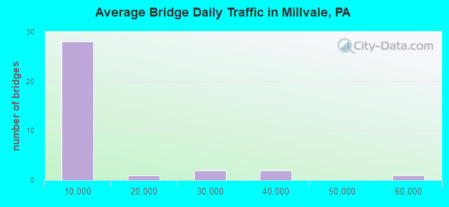
- 303,091Total average daily traffic
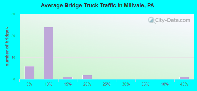
- 24,493Total average daily truck traffic
- National Bridge Inventory (NBI) Registered Bridges for Millvale
- No street view available for this location
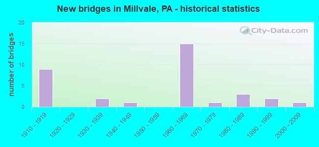
- New bridges - historical statistics
- 91910-1919
- 21930-1939
- 11940-1949
- 151960-1969
- 11970-1979
- 31980-1989
- 21990-1999
- 12000-2009
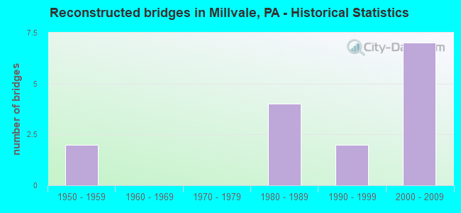
- Reconstructed bridges - Historical Statistics
- 21950-1959
- 01960-1969
- 01970-1979
- 41980-1989
- 21990-1999
- 72000-2009
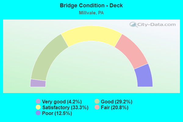
- Bridge Condition - Deck
- 4.2%Very good
- 29.2%Good
- 33.3%Satisfactory
- 20.8%Fair
- 12.5%Poor
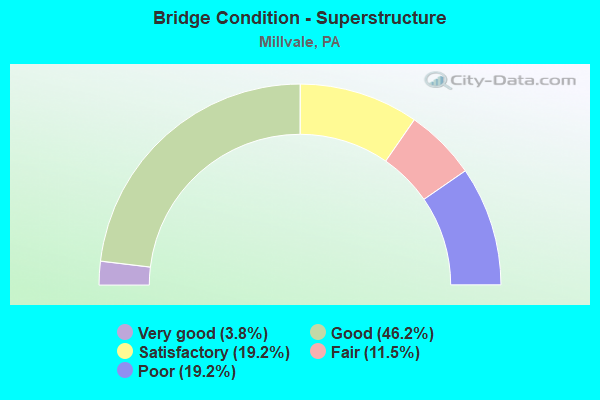
- Bridge Condition - Superstructure
- 3.8%Very good
- 46.2%Good
- 19.2%Satisfactory
- 11.5%Fair
- 19.2%Poor
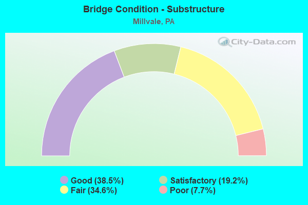
- Bridge Condition - Substructure
- 38.5%Good
- 19.2%Satisfactory
- 34.6%Fair
- 7.7%Poor
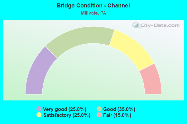
- Bridge Condition - Channel
- 25.0%Very good
- 35.0%Good
- 25.0%Satisfactory
- 15.0%Fair
Find on map >> Show street view
Structure Number: 192, Location: 2 MI SE NEW CHESTER (Lat: 39.882244, Lng: -77.069878), Route carried "on" structure: State highway , Year Built: 1940, Status: Open, Structure Length: 3.44m (11.29ft), Average Daily Traffic: 2,056 (year 2021), Truck Traffic: 8%, Average Future Daily Traffic: 2,901 (year 2032), Design Load: H 20, Features Intersected: LITTLE CONEWAGO CREEK, Facility Carried by Structure: SR 1015
Minimum Vertical Clearance: 30+ m (98+ ft), Kilometerpoint: 7.710, Lanes on structure: 2, Owner: State Highway Agency, Approaching Roadway Width: 6.1m (20.0ft), Material/Design: Concrete, Design/Construction: Tee Beam, Number Of Spans In Main Unit: 3, Length of Maximum Span: 10.4m (34.1ft), Curb or Sidewalk Widths: Left: 0.3m (1.0ft), Right: 0.3m (1.0ft), Curb-To-Curb Width: 7.3m (24.0ft), Out-to-Out Width: 8.4m (27.6ft)
Condition: Deck: Satisfactory, Superstructure: Satisfactory, Substructure: Fair, Channel: Satisfactory, Operating Rating: 65.3 metric tons, Method Used To Determine Operating Rating: Load Factor (LF), Inventory Rating: 39.0 metric tons, Method Used To Determine Inventory Rating: Load Factor (LF), Structural Evaluation: Somewhat better than minimum adequacy, Deck Geometry: High priority of replacement, Waterway Adequacy: Superior to present desirable criteria, Approach Roadway Alignment: Equal to present desirable criteria, Length Of Structure Improvement: 4.30m (14.11ft), Designated Inspection Frequency: Every 24 months, Inspection Date: May 2021, Bridge Improvement Cost: $9,000, Roadway Improvement Cost: $25,000, Total Project Cost: $116,000, Deck Structure Type: Concrete Cast-file-Place, Wearing Surface/Protective System: Wearing Surface: Bituminous, Membrane: Preformed Fabric
Find on map >> Show street view
Structure Number: 58, Location: SR 28 N.B. OVER BRIDGE ST (Lat: 40.483333, Lng: -79.975000), Route carried "on" structure: State highway 28, Year Built: 1962, Year Reconstructed: 2012, Status: Open, Structure Length: 2.32m (7.61ft), Average Daily Traffic: 26,192 (year 2022), Truck Traffic: 7%, Average Future Daily Traffic: 35,593 (year 2032), Design Load: HS 20, Features Intersected: BRIDGE ST.
Minimum Vertical Clearance: 30+ m (98+ ft), Kilometerpoint: 4.075, Lanes on structure: 2, Lanes under structure: 2, Base Highway Network: Yes, Owner: State Highway Agency, Approaching Roadway Width: 8.2m (26.9ft), Skew: 9 degrees, Material/Design: Steel, Design/Construction: Stringer/Multi-beam, Number Of Spans In Main Unit: 1, Length of Maximum Span: 21.9m (71.9ft), Curb or Sidewalk Widths: Left: 0.2m (0.7ft), Right: 0.2m (0.7ft), Curb-To-Curb Width: 11.6m (38.1ft), Out-to-Out Width: 12.7m (41.7ft)
Condition: Deck: Good, Superstructure: Satisfactory, Substructure: Satisfactory, Operating Rating: 91.6 metric tons, Method Used To Determine Operating Rating: Load Factor (LF), Inventory Rating: 54.4 metric tons, Method Used To Determine Inventory Rating: Load Factor (LF), Structural Evaluation: Equal to present minimum criteria, Deck Geometry: Equal to present minimum criteria, Underclear: High priority of corrective action, Approach Roadway Alignment: Equal to present desirable criteria, Length Of Structure Improvement: 2.30m (7.55ft), Designated Inspection Frequency: Every 24 months, Inspection Date: April 2020, Deck Structure Type: Concrete Cast-file-Place, Wearing Surface/Protective System: Wearing Surface: Monolithic Concrete, Deck Protection: Epoxy Coated Reinforcing
Find on map >> Show street view
Structure Number: 582, Location: SR 28 N.B. OVER RAMP B (Lat: 40.478086, Lng: -79.967953), Route carried "on" structure: State highway 28, Year Built: 1963, Year Reconstructed: 2012, Status: Open, Structure Length: 0.98m (3.22ft), Average Daily Traffic: 33,877 (year 2022), Truck Traffic: 8%, Average Future Daily Traffic: 32,202 (year 2032), Design Load: HS 20, Features Intersected: RAMP B
Minimum Vertical Clearance: 30+ m (98+ ft), Kilometerpoint: 4.075, Lanes on structure: 2, Lanes under structure: 1, Base Highway Network: Yes, Owner: State Highway Agency, Approaching Roadway Width: 11.0m (36.1ft), Skew: 1 degrees, Material/Design: Concrete, Design/Construction: Tee Beam, Number Of Spans In Main Unit: 1, Length of Maximum Span: 9.1m (29.9ft), Curb or Sidewalk Widths: Left: 0.2m (0.7ft), Right: 0.2m (0.7ft), Curb-To-Curb Width: 10.9m (35.8ft), Out-to-Out Width: 12.0m (39.4ft)
Condition: Deck: Satisfactory, Superstructure: Satisfactory, Substructure: Satisfactory, Operating Rating: 41.7 metric tons, Method Used To Determine Operating Rating: Load Factor (LF), Inventory Rating: 25.4 metric tons, Method Used To Determine Inventory Rating: Load Factor (LF), Structural Evaluation: Equal to present minimum criteria, Deck Geometry: Meets minimum limits, Underclear: Equal to present desirable criteria, Approach Roadway Alignment: Equal to present desirable criteria, Length Of Structure Improvement: 1.00m (3.28ft), Designated Inspection Frequency: Every 24 months, Inspection Date: April 2020, Deck Structure Type: Concrete Cast-file-Place, Wearing Surface/Protective System: Wearing Surface: Latex Concrete
Find on map >> Show street view
Structure Number: 583, Location: 70 S.B.O/RP.B & BRIDGE ST (Lat: 40.477244, Lng: -79.968978), Route carried "on" structure: State highway 28, Year Built: 1963, Year Reconstructed: 2012, Status: Open, Structure Length: 8.38m (27.49ft), Average Daily Traffic: 25,375 (year 2022), Truck Traffic: 8%, Average Future Daily Traffic: 34,484 (year 2032), Design Load: HS 20, Features Intersected: (4009) RP B & BRIDGE ST
Minimum Vertical Clearance: 30+ m (98+ ft), Kilometerpoint: 4.067, Lanes on structure: 2, Lanes under structure: 15, Base Highway Network: Yes, Owner: State Highway Agency, Approaching Roadway Width: 8.5m (27.9ft), Skew: 9 degrees, Material/Design: Steel, Design/Construction: Stringer/Multi-beam, Number Of Spans In Main Unit: 1, Number Of Approach Spans: 3, Length of Maximum Span: 30.5m (100.1ft), Curb or Sidewalk Widths: Left: 0.2m (0.7ft), Right: 0.2m (0.7ft), Curb-To-Curb Width: 8.8m (28.9ft), Out-to-Out Width: 9.9m (32.5ft)
Condition: Deck: Good, Superstructure: Good, Substructure: Good, Operating Rating: 53.5 metric tons, Method Used To Determine Operating Rating: Load Factor (LF), Inventory Rating: 31.8 metric tons, Method Used To Determine Inventory Rating: Load Factor (LF), Structural Evaluation: Better than present minimum criteria, Deck Geometry: Meets minimum limits, Underclear: High priority of corrective action, Approach Roadway Alignment: Equal to present desirable criteria, Length Of Structure Improvement: 8.40m (27.56ft), Designated Inspection Frequency: Every 24 months, Inspection Date: April 2020, Bridge Improvement Cost: $15,000, Roadway Improvement Cost: $100,000, Total Project Cost: $197,000, Deck Structure Type: Concrete Cast-file-Place, Wearing Surface/Protective System: Wearing Surface: Monolithic Concrete, Deck Protection: Epoxy Coated Reinforcing
Find on map >> Show street view
Structure Number: 584, Location: MILLVALE OVER RAMP A (Lat: 40.478586, Lng: -79.967269), Route carried "on" structure: State highway 28, Year Built: 1963, Year Reconstructed: 2012, Status: Open, Structure Length: 1.83m (6.00ft), Average Daily Traffic: 59,252 (year 2022), Truck Traffic: 8%, Average Future Daily Traffic: 66,686 (year 2032), Design Load: HS 20, Features Intersected: SR 8046 RAMP A
Minimum Vertical Clearance: 30+ m (98+ ft), Kilometerpoint: 4.075, Lanes on structure: 4, Lanes under structure: 1, Base Highway Network: Yes, Owner: State Highway Agency, Approaching Roadway Width: 22.3m (73.2ft), Skew: 34 degrees, Material/Design: Steel, Design/Construction: Stringer/Multi-beam, Number Of Spans In Main Unit: 1, Length of Maximum Span: 17.1m (56.1ft), Curb or Sidewalk Widths: Left: 0.2m (0.7ft), Right: 0.2m (0.7ft), Curb-To-Curb Width: 22.3m (73.2ft), Out-to-Out Width: 23.4m (76.8ft)
Condition: Deck: Good, Superstructure: Good, Substructure: Good, Inventory Rating: 60.8 metric tons, Method Used To Determine Inventory Rating: Load Factor (LF), Structural Evaluation: Better than present minimum criteria, Deck Geometry: Superior to present desirable criteria, Underclear: High priority of corrective action, Approach Roadway Alignment: Equal to present desirable criteria, Length Of Structure Improvement: 1.80m (5.91ft), Designated Inspection Frequency: Every 24 months, Inspection Date: April 2020, Deck Structure Type: Concrete Cast-file-Place, Wearing Surface/Protective System: Wearing Surface: Monolithic Concrete, Deck Protection: Epoxy Coated Reinforcing
Find on map >> Show street view
Structure Number: 192, Location: MILLVALE @ 28 NB OFF RAMP (Lat: 40.480808, Lng: -79.970794), Route carried "on" structure: State highway , Year Built: 1960, Status: Open, Structure Length: 1.52m (4.99ft), Average Daily Traffic: 8,864 (year 2020), Truck Traffic: 4%, Average Future Daily Traffic: 13,258 (year 2032), Design Load: H 20, Features Intersected: GIRTYS RUN, Facility Carried by Structure: EVERGREEN RD
Minimum Vertical Clearance: 30+ m (98+ ft), Kilometerpoint: 0.642, Lanes on structure: 4, Owner: State Highway Agency, Approaching Roadway Width: 14.6m (47.9ft), Skew: 21 degrees, Material/Design: Steel, Design/Construction: Stringer/Multi-beam, Number Of Spans In Main Unit: 1, Length of Maximum Span: 13.4m (44.0ft), Curb or Sidewalk Widths: Left: 1.5m (4.9ft), Right: 0.0m, Curb-To-Curb Width: 15.8m (51.8ft), Out-to-Out Width: 17.4m (57.1ft)
Condition: Deck: Fair, Superstructure: Fair, Substructure: Fair, Channel: Fair, Operating Rating: 49.0 metric tons, Method Used To Determine Operating Rating: Field evaluation and documented engineering judgment, Inventory Rating: 32.7 metric tons, Method Used To Determine Inventory Rating: Field evaluation and documented engineering judgment, Structural Evaluation: Somewhat better than minimum adequacy, Deck Geometry: Meets minimum limits, Waterway Adequacy: Equal to present minimum criteria, Approach Roadway Alignment: Equal to present desirable criteria, Length Of Structure Improvement: 1.50m (4.92ft), Designated Inspection Frequency: Every 24 months, Inspection Date: December 2020, Bridge Improvement Cost: $11,000, Roadway Improvement Cost: $34,000, Total Project Cost: $153,000, Deck Structure Type: Concrete Cast-file-Place, Wearing Surface/Protective System: Wearing Surface: Monolithic Concrete
Find on map >> Show street view
Structure Number: 1921, Location: 1044' S.W. OF SR 4004 (Lat: 40.488081, Lng: -79.972600), Route carried "on" structure: State highway , Year Built: 1982, Status: Open, Structure Length: 0.94m (3.08ft), Average Daily Traffic: 9,909 (year 2022), Truck Traffic: 5%, Average Future Daily Traffic: 13,690 (year 2032), Design Load: HS 20, Features Intersected: GIRTYS RUN, Facility Carried by Structure: EVERGREEN ROAD
Minimum Vertical Clearance: 30+ m (98+ ft), Kilometerpoint: 1.458, Lanes on structure: 2, Owner: State Highway Agency, Approaching Roadway Width: 10.1m (33.1ft), Skew: 2 degrees, Material/Design: Concrete, Design/Construction: Slab, Number Of Spans In Main Unit: 1, Length of Maximum Span: 8.2m (26.9ft), Curb or Sidewalk Widths: Left: 2.7m (8.9ft), Right: 2.7m (8.9ft), Curb-To-Curb Width: 9.9m (32.5ft), Out-to-Out Width: 15.4m (50.5ft)
Condition: Deck: Satisfactory, Superstructure: Good, Substructure: Good, Channel: Satisfactory, Operating Rating: 67.1 metric tons, Method Used To Determine Operating Rating: Load Factor (LF), Inventory Rating: 39.9 metric tons, Method Used To Determine Inventory Rating: Load Factor (LF), Structural Evaluation: Better than present minimum criteria, Deck Geometry: Meets minimum limits, Waterway Adequacy: Equal to present minimum criteria, Approach Roadway Alignment: Equal to present minimum criteria, Length Of Structure Improvement: 0.90m (2.95ft), Designated Inspection Frequency: Every 24 months, Inspection Date: Febuary 2020, Deck Structure Type: Concrete Cast-file-Place, Wearing Surface/Protective System: Wearing Surface: Bituminous, Deck Protection: Epoxy Coated Reinforcing
Find on map >> Show street view
Structure Number: 1922, Location: 200' SOUTH OF SR 4004 (Lat: 40.490047, Lng: -79.971833), Route carried "on" structure: State highway , Year Built: 1982, Status: Open, Structure Length: 0.94m (3.08ft), Average Daily Traffic: 9,909 (year 2022), Truck Traffic: 5%, Average Future Daily Traffic: 13,690 (year 2032), Design Load: HS 20, Features Intersected: GIRTYS RUN, Facility Carried by Structure: EVERGREEN RD
Minimum Vertical Clearance: 30+ m (98+ ft), Kilometerpoint: 2.208, Lanes on structure: 2, Owner: State Highway Agency, Approaching Roadway Width: 9.8m (32.2ft), Skew: 3 degrees, Material/Design: Concrete, Design/Construction: Slab, Number Of Spans In Main Unit: 1, Length of Maximum Span: 8.8m (28.9ft), Curb or Sidewalk Widths: Left: 2.7m (8.9ft), Right: 2.7m (8.9ft), Curb-To-Curb Width: 9.9m (32.5ft), Out-to-Out Width: 15.4m (50.5ft)
Condition: Deck: Good, Superstructure: Good, Substructure: Good, Channel: Satisfactory, Operating Rating: 63.5 metric tons, Method Used To Determine Operating Rating: Load Factor (LF), Inventory Rating: 38.1 metric tons, Method Used To Determine Inventory Rating: Load Factor (LF), Structural Evaluation: Better than present minimum criteria, Deck Geometry: Meets minimum limits, Waterway Adequacy: Equal to present minimum criteria, Approach Roadway Alignment: Equal to present desirable criteria, Length Of Structure Improvement: 0.90m (2.95ft), Designated Inspection Frequency: Every 24 months, Inspection Date: Febuary 2020, Bridge Improvement Cost: $5,000, Roadway Improvement Cost: $25,000, Total Project Cost: $71,000, Deck Structure Type: Concrete Cast-file-Place, Wearing Surface/Protective System: Wearing Surface: Bituminous, Deck Protection: Epoxy Coated Reinforcing
Find on map >> Show street view
Structure Number: 1923, Location: AT INT NORTH AVE MILLVALE (Lat: 40.493203, Lng: -79.975069), Route carried "on" structure: State highway , Year Built: 1932, Status: Open, Structure Length: 0.94m (3.08ft), Average Daily Traffic: 10,144 (year 2022), Truck Traffic: 4%, Average Future Daily Traffic: 13,827 (year 2032), Design Load: HS 20, Features Intersected: GIRTYS RUN, Facility Carried by Structure: EVERGREEN ROAD
Minimum Vertical Clearance: 30+ m (98+ ft), Kilometerpoint: 2.208, Lanes on structure: 2, Owner: State Highway Agency, Approaching Roadway Width: 12.2m (40.0ft), Material/Design: Concrete, Design/Construction: Arch - Deck, Number Of Spans In Main Unit: 1, Length of Maximum Span: 9.4m (30.8ft), Curb or Sidewalk Widths: Left: 3.5m (11.5ft), Right: 2.6m (8.5ft), Curb-To-Curb Width: 9.8m (32.2ft), Out-to-Out Width: 18.1m (59.4ft)
Condition: Superstructure: Fair, Substructure: Fair, Channel: Fair, Operating Rating: 49.0 metric tons, Method Used To Determine Operating Rating: Field evaluation and documented engineering judgment, Inventory Rating: 32.7 metric tons, Method Used To Determine Inventory Rating: Field evaluation and documented engineering judgment, Structural Evaluation: Somewhat better than minimum adequacy, Deck Geometry: Meets minimum limits, Waterway Adequacy: Equal to present minimum criteria, Approach Roadway Alignment: Equal to present desirable criteria, Length Of Structure Improvement: 1.00m (3.28ft), Designated Inspection Frequency: Every 24 months, Inspection Date: Febuary 2020, Bridge Improvement Cost: $33,000, Roadway Improvement Cost: $98,000, Total Project Cost: $449,000
Find on map >> Show street view
Structure Number: 2615, Location: 445001 AT BABCOCK BLVD (Lat: 40.493000, Lng: -79.975097), Route carried "on" structure: Business City street , Year Built: 1931, Status: Open, Structure Length: 1.58m (5.18ft), Average Daily Traffic: 2,500 (year 2005), Truck Traffic: 6%, Average Future Daily Traffic: 2,500 (year 2025), Design Load: HS 20, Features Intersected: GIRTYS RUN, Facility Carried by Structure: NORTH AV
Minimum Vertical Clearance: 30+ m (98+ ft), Kilometerpoint: 0.000, Lanes on structure: 2, Owner: City or Municipal Highway Agency, Approaching Roadway Width: 10.7m (35.1ft), Skew: 2 degrees, Material/Design: Concrete, Design/Construction: Arch - Deck, Number Of Spans In Main Unit: 1, Length of Maximum Span: 12.2m (40.0ft), Curb or Sidewalk Widths: Left: 3.4m (11.2ft), Right: 2.4m (7.9ft), Curb-To-Curb Width: 11.0m (36.1ft), Out-to-Out Width: 18.3m (60.0ft)
Condition: Superstructure: Satisfactory, Substructure: Satisfactory, Channel: Satisfactory, Operating Rating: 68.0 metric tons, Method Used To Determine Operating Rating: Field evaluation and documented engineering judgment, Inventory Rating: 40.8 metric tons, Method Used To Determine Inventory Rating: Field evaluation and documented engineering judgment, Structural Evaluation: Equal to present minimum criteria, Deck Geometry: Somewhat better than minimum adequacy, Waterway Adequacy: Better than present minimum criteria, Approach Roadway Alignment: Equal to present desirable criteria, Length Of Structure Improvement: 1.20m (3.94ft), Designated Inspection Frequency: Every 24 months, Inspection Date: April 2021, Bridge Improvement Cost: $2,000, Roadway Improvement Cost: $6,000, Total Project Cost: $47,000, Wearing Surface/Protective System: Wearing Surface: Bituminous
Find on map >> Show street view
Structure Number: 2616, Location: 445002 AT FRANKLIN ST (Lat: 40.490436, Lng: -79.972378), Route carried "on" structure: Business City street , Year Built: 1982, Status: Open, Structure Length: 0.94m (3.08ft), Average Daily Traffic: 2,500 (year 2005), Truck Traffic: 6%, Average Future Daily Traffic: 2,500 (year 2025), Design Load: HS 20, Features Intersected: GIRTYS RUN, Facility Carried by Structure: NORTH AV
Minimum Vertical Clearance: 30+ m (98+ ft), Kilometerpoint: 0.000, Lanes on structure: 2, Owner: City or Municipal Highway Agency, Approaching Roadway Width: 11.0m (36.1ft), Skew: 1 degrees, Material/Design: Prestressed concrete, Design/Construction: Box Beam or Girders - Multiple, Number Of Spans In Main Unit: 1, Length of Maximum Span: 8.2m (26.9ft), Curb or Sidewalk Widths: Left: 3.4m (11.2ft), Right: 3.7m (12.1ft), Curb-To-Curb Width: 11.0m (36.1ft), Out-to-Out Width: 18.3m (60.0ft)
Condition: Deck: Good, Superstructure: Good, Substructure: Good, Channel: Good, Inventory Rating: 68.9 metric tons, Method Used To Determine Inventory Rating: Load Factor (LF), Structural Evaluation: Better than present minimum criteria, Deck Geometry: Somewhat better than minimum adequacy, Waterway Adequacy: Better than present minimum criteria, Approach Roadway Alignment: Meets minimum limits, Length Of Structure Improvement: 0.90m (2.95ft), Designated Inspection Frequency: Every 24 months, Inspection Date: April 2021, Bridge Improvement Cost: $1,000, Roadway Improvement Cost: $25,000, Total Project Cost: $30,000, Deck Structure Type: Concrete Cast-file-Place, Wearing Surface/Protective System: Wearing Surface: Bituminous, Deck Protection: Epoxy Coated Reinforcing
Find on map >> Show street view
Structure Number: 2617, Location: 445003 AT FREDERICK ST (Lat: 40.488039, Lng: -79.973269), Route carried "on" structure: Business City street , Year Built: 1911, Year Reconstructed: 1994, Status: Open, Structure Length: 1.19m (3.90ft), Average Daily Traffic: 2,500 (year 2005), Truck Traffic: 6%, Average Future Daily Traffic: 5,500 (year 2030), Design Load: HS 25 or greater, Features Intersected: GIRTYS RUN, Facility Carried by Structure: NORTH AV
Minimum Vertical Clearance: 30+ m (98+ ft), Kilometerpoint: 0.000, Lanes on structure: 2, Owner: City or Municipal Highway Agency, Approaching Roadway Width: 11.0m (36.1ft), Skew: 2 degrees, Material/Design: Steel, Design/Construction: Stringer/Multi-beam, Number Of Spans In Main Unit: 1, Length of Maximum Span: 11.0m (36.1ft), Curb or Sidewalk Widths: Left: 3.7m (12.1ft), Right: 3.5m (11.5ft), Curb-To-Curb Width: 11.0m (36.1ft), Out-to-Out Width: 18.1m (59.4ft)
Condition: Deck: Satisfactory, Superstructure: Good, Substructure: Good, Channel: Satisfactory, Operating Rating: 61.7 metric tons, Method Used To Determine Operating Rating: Load Factor (LF), Inventory Rating: 36.3 metric tons, Method Used To Determine Inventory Rating: Load Factor (LF), Structural Evaluation: Better than present minimum criteria, Deck Geometry: Somewhat better than minimum adequacy, Waterway Adequacy: Better than present minimum criteria, Approach Roadway Alignment: Equal to present desirable criteria, Length Of Structure Improvement: 1.20m (3.94ft), Designated Inspection Frequency: Every 24 months, Inspection Date: April 2021, Deck Structure Type: Concrete Cast-file-Place, Wearing Surface/Protective System: Wearing Surface: Monolithic Concrete, Deck Protection: Epoxy Coated Reinforcing
Find on map >> Show street view
Structure Number: 2618, Location: NORTH AVE AT KLOPFER ST (Lat: 40.485661, Lng: -79.973117), Route carried "on" structure: Business City street , Year Built: 2006, Status: Open, Structure Length: 1.68m (5.51ft), Average Daily Traffic: 4,500 (year 2010), Truck Traffic: 6%, Average Future Daily Traffic: 4,950 (year 2025), Design Load: HS 25 or greater, Features Intersected: GIRTYS RUN, Facility Carried by Structure: NORTH AV
Minimum Vertical Clearance: 30+ m (98+ ft), Kilometerpoint: 0.000, Lanes on structure: 2, Owner: City or Municipal Highway Agency, Approaching Roadway Width: 10.4m (34.1ft), Skew: 6 degrees, Material/Design: Steel, Number Of Spans In Main Unit: 1, Length of Maximum Span: 16.5m (54.1ft), Curb or Sidewalk Widths: Left: 2.4m (7.9ft), Right: 2.4m (7.9ft), Curb-To-Curb Width: 10.4m (34.1ft), Out-to-Out Width: 27.0m (88.6ft)
Condition: Deck: Very good, Superstructure: Very good, Substructure: Satisfactory, Channel: Very good, Operating Rating: 57.2 metric tons, Method Used To Determine Operating Rating: Allowable Stress (AS), Inventory Rating: 33.6 metric tons, Method Used To Determine Inventory Rating: Allowable Stress (AS), Structural Evaluation: Equal to present minimum criteria, Deck Geometry: Somewhat better than minimum adequacy, Waterway Adequacy: Better than present minimum criteria, Approach Roadway Alignment: Equal to present desirable criteria, Length Of Structure Improvement: 0.90m (2.95ft), Designated Inspection Frequency: Every 24 months, Critical Feature Inspection Frequency: Every 24 months, Inspection Date: April 2020, Critical Feature Inspection Date: April 2020, Bridge Improvement Cost: $26,000, Roadway Improvement Cost: $77,000, Total Project Cost: $351,000, Deck Structure Type: Concrete Cast-file-Place, Wearing Surface/Protective System: Wearing Surface: Monolithic Concrete, Deck Protection: Epoxy Coated Reinforcing
Find on map >> Show street view
Structure Number: 2619, Location: 40' East of North Ave (Lat: 40.485250, Lng: -79.972917), Route carried "on" structure: Business City street , Year Built: 1915, Status: Posted for load, Structure Length: 0.91m (2.99ft), Average Daily Traffic: 1,000 (year 2005), Truck Traffic: 6%, Average Future Daily Traffic: 1,000 (year 2025), Design Load: HS 20, Features Intersected: GIRTYS RUN, Facility Carried by Structure: KLOPFER ST
Minimum Vertical Clearance: 30+ m (98+ ft), Kilometerpoint: 0.000, Lanes on structure: 2, Owner: City or Municipal Highway Agency, Approaching Roadway Width: 9.4m (30.8ft), Skew: 1 degrees, Material/Design: Steel, Design/Construction: Stringer/Multi-beam, Number Of Spans In Main Unit: 1, Length of Maximum Span: 8.5m (27.9ft), Curb or Sidewalk Widths: Left: 1.8m (5.9ft), Right: 3.2m (10.5ft), Curb-To-Curb Width: 9.4m (30.8ft), Out-to-Out Width: 14.6m (47.9ft)
Condition: Deck: Poor, Superstructure: Poor, Substructure: Poor, Channel: Good, Operating Rating: 32.7 metric tons, Method Used To Determine Operating Rating: Load Factor (LF), Inventory Rating: 20.0 metric tons, Method Used To Determine Inventory Rating: Load Factor (LF), Structural Evaluation: Meets minimum limits, Deck Geometry: Equal to present minimum criteria, Waterway Adequacy: Better than present minimum criteria, Approach Roadway Alignment: Equal to present desirable criteria, Bridge Posting: Required (Relationship of Operating Rating to Maximum Legal Load: 30.0 - 39.9% below), Length Of Structure Improvement: 0.90m (2.95ft), Designated Inspection Frequency: Every 24 months, Other Special Inspection Frequency: Every 12 months, Inspection Date: April 2020, Other Special Inspection Date: April 2021, Bridge Improvement Cost: $8,000, Roadway Improvement Cost: $25,000, Total Project Cost: $113,000, Deck Structure Type: Concrete Cast-file-Place, Wearing Surface/Protective System: Wearing Surface: Bituminous
Find on map >> Show street view
Structure Number: 262, Location: FREMONT 25' FROM NORTH AV (Lat: 40.481472, Lng: -79.973667), Route carried "on" structure: Business City street , Year Built: 1911, Status: Posted for load, Structure Length: 0.91m (2.99ft), Average Daily Traffic: 50 (year 2006), Truck Traffic: 1%, Average Future Daily Traffic: 50 (year 2026), Design Load: HS 20, Features Intersected: GIRTYS RUN, Facility Carried by Structure: FREMONT ST
Minimum Vertical Clearance: 30+ m (98+ ft), Kilometerpoint: 0.000, Lanes on structure: 2, Owner: City or Municipal Highway Agency, Approaching Roadway Width: 6.1m (20.0ft), Material/Design: Steel, Design/Construction: Stringer/Multi-beam, Number Of Spans In Main Unit: 1, Length of Maximum Span: 7.9m (25.9ft), Curb or Sidewalk Widths: Left: 0.0m, Right: 0.9m (3.0ft), Curb-To-Curb Width: 6.1m (20.0ft), Out-to-Out Width: 11.4m (37.4ft)
Condition: Deck: Poor, Superstructure: Poor, Substructure: Fair, Channel: Very good, Operating Rating: 8.2 metric tons, Method Used To Determine Operating Rating: Load Factor (LF), Inventory Rating: 4.5 metric tons, Method Used To Determine Inventory Rating: Load Factor (LF), Structural Evaluation: High priority of replacement, Deck Geometry: Somewhat better than minimum adequacy, Waterway Adequacy: Better than present minimum criteria, Approach Roadway Alignment: Equal to present desirable criteria, Bridge Posting: Required (Relationship of Operating Rating to Maximum Legal Load: > 39.9% below), Length Of Structure Improvement: 0.90m (2.95ft), Designated Inspection Frequency: Every 24 months, Other Special Inspection Frequency: Every 12 months, Inspection Date: April 2021, Other Special Inspection Date: April 2021, Bridge Improvement Cost: $13,000, Roadway Improvement Cost: $38,000, Total Project Cost: $174,000, Deck Structure Type: Concrete Cast-file-Place, Wearing Surface/Protective System: Wearing Surface: Bituminous
Find on map >> Show street view
Structure Number: 2621, Location: 445007 AT NORTH AVE (Lat: 40.481511, Lng: -79.973992), Route carried "on" structure: Business City street , Year Built: 1911, Year Reconstructed: 1950, Status: Posted for load, Structure Length: 0.88m (2.89ft), Average Daily Traffic: 4,500 (year 2006), Truck Traffic: 6%, Average Future Daily Traffic: 4,500 (year 2026), Design Load: HS 20, Features Intersected: GIRTYS RUN, Facility Carried by Structure: LINCOLN AV
Minimum Vertical Clearance: 30+ m (98+ ft), Kilometerpoint: 0.000, Lanes on structure: 2, Owner: City or Municipal Highway Agency, Approaching Roadway Width: 10.1m (33.1ft), Design/Construction: Stringer/Multi-beam, Number Of Spans In Main Unit: 1, Length of Maximum Span: 7.9m (25.9ft), Curb or Sidewalk Widths: Left: 2.6m (8.5ft), Right: 2.6m (8.5ft), Curb-To-Curb Width: 9.9m (32.5ft), Out-to-Out Width: 15.2m (49.9ft)
Condition: Deck: Fair, Superstructure: Poor, Substructure: Fair, Channel: Very good, Operating Rating: 33.6 metric tons, Method Used To Determine Operating Rating: Load Factor (LF), Inventory Rating: 20.0 metric tons, Method Used To Determine Inventory Rating: Load Factor (LF), Structural Evaluation: Meets minimum limits, Deck Geometry: Meets minimum limits, Waterway Adequacy: Better than present minimum criteria, Approach Roadway Alignment: Equal to present desirable criteria, Bridge Posting: Required (Relationship of Operating Rating to Maximum Legal Load: 30.0 - 39.9% below), Length Of Structure Improvement: 0.90m (2.95ft), Designated Inspection Frequency: Every 24 months, Other Special Inspection Frequency: Every 12 months, Inspection Date: April 2021, Other Special Inspection Date: April 2021, Bridge Improvement Cost: $9,000, Roadway Improvement Cost: $31,000, Total Project Cost: $123,000, Deck Structure Type: Concrete Cast-file-Place, Wearing Surface/Protective System: Wearing Surface: Other
Find on map >> Show street view
Structure Number: 2622, Location: Int Grant Ave, North Ave (Lat: 40.480750, Lng: -79.974667), Route carried "on" structure: Business City street , Year Built: 1914, Year Reconstructed: 1986, Status: Posted for load, Structure Length: 0.91m (2.99ft), Average Daily Traffic: 4,500 (year 2006), Truck Traffic: 6%, Average Future Daily Traffic: 4,500 (year 2026), Design Load: HS 20, Features Intersected: Girty's Run, Facility Carried by Structure: Grant Avenue
Minimum Vertical Clearance: 30+ m (98+ ft), Kilometerpoint: 0.000, Lanes on structure: 2, Owner: City or Municipal Highway Agency, Approaching Roadway Width: 9.8m (32.2ft), Material/Design: Steel, Design/Construction: Stringer/Multi-beam, Number Of Spans In Main Unit: 1, Length of Maximum Span: 8.5m (27.9ft), Curb or Sidewalk Widths: Left: 2.6m (8.5ft), Right: 2.6m (8.5ft), Curb-To-Curb Width: 9.9m (32.5ft), Out-to-Out Width: 15.1m (49.5ft)
Condition: Deck: Poor, Superstructure: Poor, Substructure: Fair, Channel: Very good, Operating Rating: 35.4 metric tons, Method Used To Determine Operating Rating: Load Factor (LF), Inventory Rating: 20.9 metric tons, Method Used To Determine Inventory Rating: Load Factor (LF), Structural Evaluation: Meets minimum limits, Deck Geometry: Meets minimum limits, Waterway Adequacy: Better than present minimum criteria, Approach Roadway Alignment: Equal to present desirable criteria, Bridge Posting: Required (Relationship of Operating Rating to Maximum Legal Load: 20.0 - 29.9% below), Length Of Structure Improvement: 0.90m (2.95ft), Designated Inspection Frequency: Every 24 months, Other Special Inspection Frequency: Every 12 months, Inspection Date: April 2021, Other Special Inspection Date: April 2021, Bridge Improvement Cost: $9,000, Roadway Improvement Cost: $25,000, Total Project Cost: $117,000, Deck Structure Type: Concrete Cast-file-Place, Wearing Surface/Protective System: Wearing Surface: Bituminous
Find on map >> Show street view
Structure Number: 2623, Location: SW of Grant St. (Lat: 40.479417, Lng: -79.974889), Route carried "on" structure: City street , Year Built: 1911, Year Reconstructed: 1990, Status: Open, Structure Length: 0.94m (3.08ft), Average Daily Traffic: 200 (year 2005), Truck Traffic: 6%, Average Future Daily Traffic: 200 (year 2025), Design Load: HS 20+Mod, Features Intersected: GIRTYS RUN, Facility Carried by Structure: SEDGWICK ST
Minimum Vertical Clearance: 30+ m (98+ ft), Kilometerpoint: 0.000, Lanes on structure: 2, Owner: City or Municipal Highway Agency, Approaching Roadway Width: 4.3m (14.1ft), Skew: 3 degrees, Material/Design: Steel, Design/Construction: Stringer/Multi-beam, Number Of Spans In Main Unit: 1, Length of Maximum Span: 9.4m (30.8ft), Curb-To-Curb Width: 4.3m (14.1ft), Out-to-Out Width: 4.6m (15.1ft)
Condition: Deck: Satisfactory, Superstructure: Good, Substructure: Fair, Channel: Good, Operating Rating: 77.1 metric tons, Method Used To Determine Operating Rating: Load Factor (LF), Inventory Rating: 46.3 metric tons, Method Used To Determine Inventory Rating: Load Factor (LF), Structural Evaluation: Somewhat better than minimum adequacy, Deck Geometry: High priority of replacement, Waterway Adequacy: Better than present minimum criteria, Approach Roadway Alignment: Meets minimum limits, Length Of Structure Improvement: 0.90m (2.95ft), Designated Inspection Frequency: Every 24 months, Critical Feature Inspection Frequency: Every 24 months, Inspection Date: April 2021, Critical Feature Inspection Date: April 2021, Bridge Improvement Cost: $1,000, Roadway Improvement Cost: $15,000, Total Project Cost: $20,000, Deck Structure Type: Concrete Cast-file-Place, Wearing Surface/Protective System: Wearing Surface: Monolithic Concrete, Deck Protection: Epoxy Coated Reinforcing
Find on map >> Show street view
Structure Number: 2624, Location: 445010 SHERMAN STREET (Lat: 40.478583, Lng: -79.972694), Route carried "on" structure: Business City street , Year Built: 1911, Year Reconstructed: 1992, Status: Open, Structure Length: 0.79m (2.59ft), Average Daily Traffic: 500 (year 2005), Truck Traffic: 5%, Average Future Daily Traffic: 550 (year 2025), Design Load: HS 25 or greater, Features Intersected: GIRTYS RUN, Facility Carried by Structure: SHERMAN ST
Minimum Vertical Clearance: 30+ m (98+ ft), Kilometerpoint: 0.000, Lanes on structure: 2, Owner: City or Municipal Highway Agency, Approaching Roadway Width: 9.1m (29.9ft), Skew: 1 degrees, Material/Design: Steel, Design/Construction: Stringer/Multi-beam, Number Of Spans In Main Unit: 1, Length of Maximum Span: 7.3m (24.0ft), Curb or Sidewalk Widths: Left: 3.2m (10.5ft), Right: 3.2m (10.5ft), Curb-To-Curb Width: 9.1m (29.9ft), Out-to-Out Width: 15.5m (50.9ft)
Condition: Deck: Satisfactory, Superstructure: Good, Substructure: Good, Channel: Good, Operating Rating: 84.4 metric tons, Method Used To Determine Operating Rating: Load Factor (LF), Inventory Rating: 50.8 metric tons, Method Used To Determine Inventory Rating: Load Factor (LF), Structural Evaluation: Better than present minimum criteria, Deck Geometry: Equal to present minimum criteria, Waterway Adequacy: Better than present minimum criteria, Approach Roadway Alignment: Equal to present minimum criteria, Length Of Structure Improvement: 0.80m (2.62ft), Designated Inspection Frequency: Every 24 months, Inspection Date: April 2021, Deck Structure Type: Concrete Cast-file-Place, Wearing Surface/Protective System: Wearing Surface: Monolithic Concrete, Membrane: Built-up, Deck Protection: Epoxy Coated Reinforcing
Find on map >> Show street view
Structure Number: 2626, Location: Int. Grant Ave, E Ohio St (Lat: 40.477942, Lng: -79.969500), Route carried "on" structure: Business City street , Year Built: 1914, Year Reconstructed: 1992, Status: Open, Structure Length: 0.91m (2.99ft), Average Daily Traffic: 4,500 (year 2005), Truck Traffic: 6%, Average Future Daily Traffic: 4,950 (year 2030), Design Load: HS 25 or greater, Features Intersected: Girty's Run, Facility Carried by Structure: Grant Avenue
Minimum Vertical Clearance: 30+ m (98+ ft), Kilometerpoint: 0.000, Lanes on structure: 2, Owner: City or Municipal Highway Agency, Approaching Roadway Width: 10.1m (33.1ft), Skew: 1 degrees, Material/Design: Steel, Design/Construction: Stringer/Multi-beam, Number Of Spans In Main Unit: 1, Length of Maximum Span: 8.5m (27.9ft), Curb or Sidewalk Widths: Left: 2.4m (7.9ft), Right: 2.3m (7.5ft), Curb-To-Curb Width: 9.9m (32.5ft), Out-to-Out Width: 15.4m (50.5ft)
Condition: Deck: Fair, Superstructure: Good, Substructure: Fair, Channel: Good, Operating Rating: 69.9 metric tons, Method Used To Determine Operating Rating: Load Factor (LF), Inventory Rating: 41.7 metric tons, Method Used To Determine Inventory Rating: Load Factor (LF), Structural Evaluation: Somewhat better than minimum adequacy, Deck Geometry: Meets minimum limits, Waterway Adequacy: Better than present minimum criteria, Approach Roadway Alignment: Equal to present desirable criteria, Length Of Structure Improvement: 0.90m (2.95ft), Designated Inspection Frequency: Every 24 months, Inspection Date: April 2021, Bridge Improvement Cost: $8,000, Roadway Improvement Cost: $50,000, Total Project Cost: $105,000, Deck Structure Type: Concrete Cast-file-Place, Wearing Surface/Protective System: Wearing Surface: Monolithic Concrete, Membrane: Built-up, Deck Protection: Epoxy Coated Reinforcing
Find on map >> Show street view
Structure Number: 2627, Location: NEAR INT. W/ EAST OHIO (Lat: 40.478611, Lng: -79.968750), Route carried "on" structure: Business City street , Year Built: 1915, Year Reconstructed: 1963, Status: Open, Structure Length: 0.98m (3.22ft), Average Daily Traffic: 4,000 (year 2005), Truck Traffic: 6%, Average Future Daily Traffic: 4,000 (year 2025), Design Load: HS 20, Features Intersected: GIRTYS RUN, Facility Carried by Structure: LINCOLN AV
Minimum Vertical Clearance: 30+ m (98+ ft), Kilometerpoint: 0.000, Lanes on structure: 2, Owner: City or Municipal Highway Agency, Approaching Roadway Width: 9.8m (32.2ft), Skew: 3 degrees, Material/Design: Steel, Design/Construction: Stringer/Multi-beam, Number Of Spans In Main Unit: 1, Length of Maximum Span: 8.8m (28.9ft), Curb or Sidewalk Widths: Left: 1.8m (5.9ft), Right: 3.2m (10.5ft), Curb-To-Curb Width: 9.8m (32.2ft), Out-to-Out Width: 14.8m (48.6ft)
Condition: Deck: Fair, Superstructure: Poor, Substructure: Poor, Channel: Good, Operating Rating: 68.9 metric tons, Method Used To Determine Operating Rating: Load Factor (LF), Inventory Rating: 40.8 metric tons, Method Used To Determine Inventory Rating: Load Factor (LF), Structural Evaluation: Meets minimum limits, Deck Geometry: Meets minimum limits, Waterway Adequacy: Better than present minimum criteria, Approach Roadway Alignment: Equal to present desirable criteria, Length Of Structure Improvement: 0.90m (2.95ft), Designated Inspection Frequency: Every 24 months, Inspection Date: April 2021, Bridge Improvement Cost: $8,000, Roadway Improvement Cost: $26,000, Total Project Cost: $113,000, Deck Structure Type: Concrete Cast-file-Place, Wearing Surface/Protective System: Wearing Surface: Bituminous
Find on map >> Show street view
Structure Number: 2839, Location: MILLVALE, 28 INTERCHNGE (Lat: 40.470000, Lng: -79.966667), Route carried "on" structure: Ramp State highway , Year Built: 1963, Year Reconstructed: 2012, Status: Open, Structure Length: 1.68m (5.51ft), Average Daily Traffic: 2,266 (year 2022), Truck Traffic: 7%, Average Future Daily Traffic: 4,063 (year 2032), Design Load: HS 20, Features Intersected: RAMP B SR 8046, Facility Carried by Structure: RAMP A
Minimum Vertical Clearance: 30+ m (98+ ft), Kilometerpoint: 0.000, Lanes on structure: 1, Lanes under structure: 1, Base Highway Network: Yes, Owner: State Highway Agency, Approaching Roadway Width: 7.9m (25.9ft), Skew: 3 degrees, Material/Design: Concrete, Design/Construction: Tee Beam, Number Of Spans In Main Unit: 1, Length of Maximum Span: 15.5m (50.9ft), Curb or Sidewalk Widths: Left: 0.2m (0.7ft), Right: 0.2m (0.7ft), Curb-To-Curb Width: 7.9m (25.9ft), Out-to-Out Width: 9.0m (29.5ft)
Condition: Deck: Satisfactory, Superstructure: Fair, Substructure: Good, Operating Rating: 39.9 metric tons, Method Used To Determine Operating Rating: Load Factor (LF), Inventory Rating: 23.6 metric tons, Method Used To Determine Inventory Rating: Load Factor (LF), Structural Evaluation: Somewhat better than minimum adequacy, Deck Geometry: Equal to present desirable criteria, Underclear: High priority of corrective action, Approach Roadway Alignment: Equal to present minimum criteria, Length Of Structure Improvement: 2.40m (7.87ft), Designated Inspection Frequency: Every 24 months, Inspection Date: April 2020, Bridge Improvement Cost: $10,000, Roadway Improvement Cost: $30,000, Total Project Cost: $137,000, Deck Structure Type: Concrete Cast-file-Place, Wearing Surface/Protective System: Wearing Surface: Latex Concrete
Find on map >> Show street view
Structure Number: 4002, Location: 0.05 MILE S. FROM PA 36 (Lat: 40.160789, Lng: -78.374547), Route carried "on" structure: State highway , Year Built: 1997, Year Reconstructed: 2012, Status: Open, Structure Length: 3.26m (10.70ft), Average Daily Traffic: 569 (year 2022), Truck Traffic: 11%, Average Future Daily Traffic: 948 (year 2032), Design Load: HS 25 or greater, Features Intersected: YELLOW CREEK RELIEF CHAN, Facility Carried by Structure: SR 1005(OLD PA 36)
Minimum Vertical Clearance: 30+ m (98+ ft), Kilometerpoint: 18.298, Lanes on structure: 2, Base Highway Network: Yes, Owner: State Highway Agency, Approaching Roadway Width: 10.4m (34.1ft), Material/Design: Prestressed concrete, Design/Construction: Box Beam or Girders - Multiple, Number Of Spans In Main Unit: 1, Length of Maximum Span: 32.0m (105.0ft), Curb or Sidewalk Widths: Left: 0.2m (0.7ft), Right: 0.2m (0.7ft), Curb-To-Curb Width: 10.4m (34.1ft), Out-to-Out Width: 11.4m (37.4ft)
Condition: Deck: Good, Superstructure: Good, Substructure: Good, Channel: Good, Inventory Rating: 49.0 metric tons, Method Used To Determine Inventory Rating: Load Factor (LF), Structural Evaluation: Better than present minimum criteria, Deck Geometry: Equal to present minimum criteria, Waterway Adequacy: Equal to present desirable criteria, Approach Roadway Alignment: Equal to present desirable criteria, Length Of Structure Improvement: 4.10m (13.45ft), Designated Inspection Frequency: Every 48 months, Inspection Date: Febuary 2020, Deck Structure Type: Concrete Cast-file-Place, Wearing Surface/Protective System: Wearing Surface: Epoxy Overlay, Deck Protection: Epoxy Coated Reinforcing
Find on map >> Show street view
Structure Number: 403, Location: OVER SR 2035 AT EXIT 149 (Lat: 39.990000, Lng: -78.240000), Route carried "on" structure: Interstate 70, Year Built: 1963, Year Reconstructed: 2004, Status: Open, Structure Length: 1.01m (3.31ft), Average Daily Traffic: 7,400 (year 2020), Truck Traffic: 42%, Average Future Daily Traffic: 9,738 (year 2032), Design Load: HS 20, Features Intersected: SR 2035
Minimum Vertical Clearance: 30+ m (98+ ft), Kilometerpoint: 1.614, Lanes on structure: 2, Lanes under structure: 2, Base Highway Network: Yes, Owner: State Highway Agency, Approaching Roadway Width: 11.6m (38.1ft), Skew: 10 degrees, Material/Design: Prestressed concrete, Design/Construction: Box Beam or Girders - Single/Spread, Number Of Spans In Main Unit: 1, Length of Maximum Span: 9.8m (32.2ft), Curb or Sidewalk Widths: Left: 0.2m (0.7ft), Right: 0.2m (0.7ft), Curb-To-Curb Width: 12.2m (40.0ft), Out-to-Out Width: 13.3m (43.6ft)
Condition: Deck: Good, Superstructure: Satisfactory, Substructure: Satisfactory, Operating Rating: 52.6 metric tons, Method Used To Determine Operating Rating: Load Factor (LF), Inventory Rating: 30.8 metric tons, Method Used To Determine Inventory Rating: Load Factor (LF), Structural Evaluation: Equal to present minimum criteria, Deck Geometry: Better than present minimum criteria, Underclear: Meets minimum limits, Approach Roadway Alignment: Equal to present desirable criteria, Length Of Structure Improvement: 1.60m (5.25ft), Designated Inspection Frequency: Every 24 months, Inspection Date: April 2021, Deck Structure Type: Concrete Cast-file-Place, Wearing Surface/Protective System: Wearing Surface: Latex Concrete, Deck Protection: Epoxy Coated Reinforcing
Find on map >> Show street view
Structure Number: 4071, Location: OVER SR 4009 (CESSNA) (Lat: 40.110192, Lng: -78.526244), Route carried "on" structure: Interstate 99, Year Built: 1978, Year Reconstructed: 2008, Status: Open, Structure Length: 5.52m (18.11ft), Average Daily Traffic: 6,722 (year 2021), Truck Traffic: 19%, Average Future Daily Traffic: 7,297 (year 2032), Design Load: HS 20, Features Intersected: SR 4009
Minimum Vertical Clearance: 30+ m (98+ ft), Kilometerpoint: 5.626, Lanes on structure: 2, Lanes under structure: 2, Base Highway Network: Yes, Owner: State Highway Agency, Approaching Roadway Width: 12.2m (40.0ft), Skew: 15 degrees, Material/Design: Steel, Design/Construction: Stringer/Multi-beam, Number Of Spans In Main Unit: 3, Length of Maximum Span: 26.5m (86.9ft), Curb or Sidewalk Widths: Left: 0.2m (0.7ft), Right: 0.2m (0.7ft), Curb-To-Curb Width: 12.8m (42.0ft), Out-to-Out Width: 13.9m (45.6ft)
Condition: Deck: Fair, Superstructure: Good, Substructure: Fair, Operating Rating: 80.7 metric tons, Method Used To Determine Operating Rating: Load Factor (LF), Inventory Rating: 48.1 metric tons, Method Used To Determine Inventory Rating: Load Factor (LF), Structural Evaluation: Somewhat better than minimum adequacy, Deck Geometry: Equal to present desirable criteria, Underclear: Equal to present minimum criteria, Approach Roadway Alignment: Equal to present desirable criteria, Length Of Structure Improvement: 24.41m (80.09ft), Designated Inspection Frequency: Every 24 months, Inspection Date: April 2020, Deck Structure Type: Concrete Cast-file-Place, Wearing Surface/Protective System: Wearing Surface: Latex Concrete, Deck Protection: Epoxy Coated Reinforcing
Find on map >> Show street view
Structure Number: 4002, Location: 445011 SHERIDAN STREET (Lat: 40.478322, Lng: -79.971350), Route carried "on" structure: Business City street , Year Built: 1998, Status: Open, Structure Length: 1.04m (3.41ft), Average Daily Traffic: 500 (year 2006), Truck Traffic: 15%, Average Future Daily Traffic: 550 (year 2026), Design Load: HS 25 or greater, Features Intersected: GIRTYS RUN, Facility Carried by Structure: SHERIDAN STREET
Minimum Vertical Clearance: 30+ m (98+ ft), Kilometerpoint: 0.000, Lanes on structure: 2, Owner: City or Municipal Highway Agency, Approaching Roadway Width: 9.1m (29.9ft), Material/Design: Steel, Design/Construction: Stringer/Multi-beam, Number Of Spans In Main Unit: 1, Length of Maximum Span: 9.8m (32.2ft), Curb or Sidewalk Widths: Left: 2.5m (8.2ft), Right: 2.1m (6.9ft), Curb-To-Curb Width: 9.2m (30.2ft), Out-to-Out Width: 15.1m (49.5ft)
Condition: Deck: Satisfactory, Superstructure: Good, Substructure: Good, Channel: Very good, Operating Rating: 58.1 metric tons, Method Used To Determine Operating Rating: Load Factor (LF), Inventory Rating: 34.5 metric tons, Method Used To Determine Inventory Rating: Load Factor (LF), Structural Evaluation: Better than present minimum criteria, Deck Geometry: Equal to present minimum criteria, Waterway Adequacy: Better than present minimum criteria, Approach Roadway Alignment: Equal to present desirable criteria, Length Of Structure Improvement: 1.00m (3.28ft), Designated Inspection Frequency: Every 24 months, Inspection Date: April 2020, Deck Structure Type: Concrete Cast-file-Place, Wearing Surface/Protective System: Wearing Surface: Monolithic Concrete, Deck Protection: Epoxy Coated Reinforcing
Find on map >> Show street view
Structure Number: 42123, Location: RT28&4009MILLVALE (Lat: 40.478333, Lng: -79.975000), Route carried "on" structure: State highway 28, Year Built: 1960, Status: Open, Structure Length: 0.76m (2.49ft), Average Daily Traffic: 33,877 (year 2022), Truck Traffic: 8%, Average Future Daily Traffic: 32,202 (year 2032), Design Load: HS 20, Features Intersected: RAMPB/AND/02400900201211
Minimum Vertical Clearance: 30+ m (98+ ft), Kilometerpoint: 4.075, Lanes on structure: 4, Base Highway Network: Yes, Owner: State Highway Agency, Approaching Roadway Width: 19.8m (65.0ft), Material/Design: Concrete, Design/Construction: Culvert, Number Of Spans In Main Unit: 1, Length of Maximum Span: 7.6m (24.9ft)
Condition: Channel: Fair, Culverts: Fair, Operating Rating: 49.0 metric tons, Method Used To Determine Operating Rating: Field evaluation and documented engineering judgment, Inventory Rating: 32.7 metric tons, Method Used To Determine Inventory Rating: Field evaluation and documented engineering judgment, Structural Evaluation: Somewhat better than minimum adequacy, Waterway Adequacy: Superior to present desirable criteria, Approach Roadway Alignment: Equal to present desirable criteria, Length Of Structure Improvement: 1.50m (4.92ft), Designated Inspection Frequency: Every 24 months, Inspection Date: December 2020
Find on map >> Show street view
Structure Number: 58, Location: SR 28 N.B. OVER BRIDGE ST (Lat: 40.483333, Lng: -79.975000), Route carried "under" structure: City street , Year Built: 1962, Structure Length: 0. m, Average Daily Traffic: 100 (year 2004), Truck Traffic: 1%, Features Intersected: BRIDGE ST., Facility Carried by Structure: SR 28 NB
Minimum Vertical Clearance: 4.62m (15.16ft), Kilometerpoint: 0.000, Lanes on structure: 2, Lanes under structure: 2, Material/Design: Steel, Design/Construction: Stringer/Multi-beam, Length of Maximum Span: 21.9m (71.9ft)
Find on map >> Show street view
Structure Number: 582, Location: SR 28 N.B. OVER RAMP B (Lat: 40.478086, Lng: -79.967953), Route carried "under" structure: Ramp State highway , Year Built: 1963, Structure Length: 0. m, Average Daily Traffic: 6,748 (year 2022), Truck Traffic: 7%, Features Intersected: RAMP B, Facility Carried by Structure: SR 0028 SB
Minimum Vertical Clearance: 6.63m (21.75ft), Kilometerpoint: 0.000, Lanes on structure: 2, Lanes under structure: 1, Material/Design: Concrete, Design/Construction: Tee Beam, Length of Maximum Span: 9.1m (29.9ft)
Find on map >> Show street view
Structure Number: 583, Location: 70 S.B.O/RP.B & BRIDGE ST (Lat: 40.477244, Lng: -79.968978), Route carried "under" structure: State highway , Year Built: 1963, Structure Length: 0. m, Average Daily Traffic: 5,718 (year 2022), Truck Traffic: 3%, Features Intersected: (4009) RP B & BRIDGE ST, Facility Carried by Structure: SR 0028 SB
Minimum Vertical Clearance: 4.34m (14.24ft), Kilometerpoint: 0.000, Lanes on structure: 2, Lanes under structure: 5, Material/Design: Steel, Design/Construction: Stringer/Multi-beam, Length of Maximum Span: 30.5m (100.1ft)
Find on map >> Show street view
Structure Number: 583, Location: 70 S.B.O/RP.B & BRIDGE ST (Lat: 40.477244, Lng: -79.968978), Route carried "under" structure: Ramp State highway , Year Built: 1963, Structure Length: 0. m, Average Daily Traffic: 6,748 (year 2022), Truck Traffic: 7%, Features Intersected: (4009) RP B & BRIDGE ST, Facility Carried by Structure: SR 0028 SB
Minimum Vertical Clearance: 5.61m (18.41ft), Kilometerpoint: 0.000, Lanes on structure: 2, Lanes under structure: 5, Material/Design: Steel, Design/Construction: Stringer/Multi-beam, Length of Maximum Span: 30.5m (100.1ft)
Find on map >> Show street view
Structure Number: 583, Location: 70 S.B.O/RP.B & BRIDGE ST (Lat: 40.477244, Lng: -79.968978), Route carried "under" structure: State highway , Year Built: 1963, Structure Length: 0. m, Average Daily Traffic: 6,601 (year 2022), Truck Traffic: 4%, Features Intersected: (4009) RP B & BRIDGE ST, Facility Carried by Structure: SR 0028 SB
Minimum Vertical Clearance: 4.34m (14.24ft), Kilometerpoint: 0.000, Lanes on structure: 2, Lanes under structure: 5, Material/Design: Steel, Design/Construction: Stringer/Multi-beam, Length of Maximum Span: 30.5m (100.1ft)
Find on map >> Show street view
Structure Number: 584, Location: MILLVALE OVER RAMP A (Lat: 40.478586, Lng: -79.967269), Route carried "under" structure: Ramp State highway , Year Built: 1963, Structure Length: 0. m, Average Daily Traffic: 2,266 (year 2022), Truck Traffic: 7%, Features Intersected: SR 8046 RAMP A, Facility Carried by Structure: SR 28 NB-SB
Minimum Vertical Clearance: 4.34m (14.24ft), Kilometerpoint: 0.000, Lanes on structure: 4, Lanes under structure: 1, Material/Design: Steel, Design/Construction: Stringer/Multi-beam, Length of Maximum Span: 17.1m (56.1ft)
Find on map >> Show street view
Structure Number: 2839, Location: MILLVALE, 28 INTERCHNGE (Lat: 40.470000, Lng: -79.966667), Route carried "under" structure: Ramp State highway , Year Built: 1963, Structure Length: 0. m, Average Daily Traffic: 6,748 (year 2022), Truck Traffic: 7%, Features Intersected: RAMP B SR 8046, Facility Carried by Structure: RAMP A
Minimum Vertical Clearance: 4.37m (14.34ft), Kilometerpoint: 0.000, Lanes on structure: 1, Lanes under structure: 1, Material/Design: Concrete, Design/Construction: Tee Beam, Length of Maximum Span: 15.5m (50.9ft)