Bridge Statistics for Millstadt, Illinois (IL)
Condition, Traffic, Stress, Structural Evaluation, Project Costs
- National Bridge Inventory (NBI) Statistics
- 10Number of bridges
- 69ft / 21.4mTotal length
- 14,100Total average daily traffic
- 900Total average daily truck traffic
- 12,318Total future (year 2032) average daily traffic
- National Bridge Inventory (NBI) Registered Bridges for Millstadt
- No street view available for this location
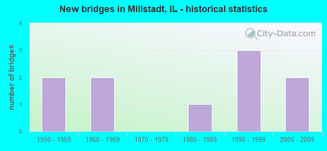
- New bridges - historical statistics
- 21950-1959
- 21960-1969
- 11980-1989
- 31990-1999
- 22000-2009


- Bridge Condition - Deck
- 28.6%Very good
- 42.9%Good
- 14.3%Fair
- 14.3%Serious

- Bridge Condition - Superstructure
- 25.0%Very good
- 37.5%Good
- 12.5%Satisfactory
- 25.0%Fair

- Bridge Condition - Substructure
- 50.0%Very good
- 25.0%Good
- 25.0%Satisfactory

- Bridge Condition - Channel
- 10.0%Excellent
- 70.0%Very good
- 10.0%Good
- 10.0%Satisfactory
Find on map >> Show street view
Structure Number: 820305, Location: 2MI N OF MILSTADT (Lat: 38.496269, Lng: -90.095158), Route carried "on" structure: State highway 163, Year Built: 2006, Status: Open, Structure Length: 3.14m (10.30ft), Average Daily Traffic: 3,950 (year 2021), Truck Traffic: 5%, Average Future Daily Traffic: 4,812 (year 2032), Design Load: HS 20, Features Intersected: S PRAIRIE duPONT CK
Minimum Vertical Clearance: 30+ m (98+ ft), Kilometerpoint: 3.943, Lanes on structure: 2, Base Highway Network: Yes, Owner: State Highway Agency, Approaching Roadway Width: 9.8m (32.2ft), Material/Design: Prestressed concrete, Design/Construction: Stringer/Multi-beam, Number Of Spans In Main Unit: 1, Length of Maximum Span: 31.4m (103.0ft), Curb-To-Curb Width: 12.2m (40.0ft), Out-to-Out Width: 13.2m (43.3ft)
Condition: Deck: Very good, Superstructure: Very good, Substructure: Very good, Channel: Very good, Operating Rating: 81.3 metric tons, Method Used To Determine Operating Rating: Load Factor (LF) rating reported by rating factor (RF) method using MS18 loading, Inventory Rating: 50.9 metric tons, Method Used To Determine Inventory Rating: Load Factor (LF) rating reported by rating factor (RF) method using MS18 loading, Structural Evaluation: Equal to present desirable criteria, Deck Geometry: Equal to present minimum criteria, Waterway Adequacy: Superior to present desirable criteria, Approach Roadway Alignment: Equal to present desirable criteria, Designated Inspection Frequency: Every 24 months, Inspection Date: August 2021, Deck Structure Type: Concrete Cast-file-Place, Wearing Surface/Protective System: Deck Protection: Epoxy Coated Reinforcing
Find on map >> Show street view
Structure Number: 823016, Location: 0.50MI E ILL 163 (Lat: 38.498950, Lng: -90.089550), Route carried "on" structure: County highway , Year Built: 1958, Status: Open, Structure Length: 1.77m (5.81ft), Average Daily Traffic: 1,550 (year 2021), Truck Traffic: 6%, Average Future Daily Traffic: 837 (year 2032), Design Load: HS 20, Features Intersected: PRAIRIE DU PONT CR, Facility Carried by Structure: CONCORDIA CH RD/CH
Minimum Vertical Clearance: 30+ m (98+ ft), Kilometerpoint: 0.595, Lanes on structure: 2, Owner: County Highway Agency, Approaching Roadway Width: 12.8m (42.0ft), Skew: 3 degrees, Material/Design: Steel, Design/Construction: Stringer/Multi-beam, Number Of Spans In Main Unit: 1, Length of Maximum Span: 16.5m (54.1ft), Curb or Sidewalk Widths: Left: 0.6m (2.0ft), Right: 0.6m (2.0ft), Curb-To-Curb Width: 9.1m (29.9ft), Out-to-Out Width: 10.9m (35.8ft)
Condition: Deck: Serious, Superstructure: Fair, Substructure: Satisfactory, Channel: Very good, Operating Rating: 59.6 metric tons, Method Used To Determine Operating Rating: Load Factor (LF) rating reported by rating factor (RF) method using MS18 loading, Inventory Rating: 35.6 metric tons, Method Used To Determine Inventory Rating: Load Factor (LF) rating reported by rating factor (RF) method using MS18 loading, Structural Evaluation: Somewhat better than minimum adequacy, Deck Geometry: Somewhat better than minimum adequacy, Waterway Adequacy: Equal to present desirable criteria, Approach Roadway Alignment: Equal to present desirable criteria, Designated Inspection Frequency: Every 24 months, Inspection Date: June 2021, Deck Structure Type: Concrete Cast-file-Place, Wearing Surface/Protective System: Wearing Surface: Other
Find on map >> Show street view
Structure Number: 823017, Location: 1.2MI E ILL RTE 163 (Lat: 38.499161, Lng: -90.074608), Route carried "on" structure: County highway , Year Built: 1967, Status: Open, Structure Length: 1.07m (3.51ft), Average Daily Traffic: 1,550 (year 2021), Truck Traffic: 6%, Average Future Daily Traffic: 837 (year 2032), Design Load: HS 20, Features Intersected: PRAIRIE DU PONT CR, Facility Carried by Structure: CONCORDIA CH RD/CH
Minimum Vertical Clearance: 30+ m (98+ ft), Kilometerpoint: 1.899, Lanes on structure: 2, Owner: County Highway Agency, Approaching Roadway Width: 12.8m (42.0ft), Skew: 4 degrees, Material/Design: Concrete continuous, Design/Construction: Culvert, Number Of Spans In Main Unit: 2, Length of Maximum Span: 5.2m (17.1ft)
Condition: Channel: Good, Culverts: Satisfactory, Operating Rating: 89.1 metric tons, Method Used To Determine Operating Rating: Load Factor (LF) rating reported by rating factor (RF) method using MS18 loading, Inventory Rating: 89.1 metric tons, Method Used To Determine Inventory Rating: Load Factor (LF) rating reported by rating factor (RF) method using MS18 loading, Structural Evaluation: Equal to present minimum criteria, Waterway Adequacy: Equal to present desirable criteria, Approach Roadway Alignment: Equal to present desirable criteria, Designated Inspection Frequency: Every 24 months, Inspection Date: Febuary 2020
Find on map >> Show street view
Structure Number: 823018, Location: 2.3MI E ILL RTE 163 (Lat: 38.498556, Lng: -90.058683), Route carried "on" structure: County highway , Year Built: 1967, Status: Open, Structure Length: 0.81m (2.66ft), Average Daily Traffic: 1,550 (year 2021), Truck Traffic: 6%, Average Future Daily Traffic: 837 (year 2032), Design Load: HS 20, Features Intersected: BRANCH PRARE DU PONT, Facility Carried by Structure: CONCORDIA CH RD/CH
Minimum Vertical Clearance: 30+ m (98+ ft), Kilometerpoint: 3.315, Lanes on structure: 2, Owner: County Highway Agency, Approaching Roadway Width: 12.8m (42.0ft), Skew: 4 degrees, Material/Design: Concrete continuous, Design/Construction: Culvert, Number Of Spans In Main Unit: 2, Length of Maximum Span: 3.9m (12.8ft), Curb-To-Curb Width: 12.8m (42.0ft), Out-to-Out Width: 12.8m (42.0ft)
Condition: Channel: Satisfactory, Culverts: Satisfactory, Operating Rating: 89.1 metric tons, Method Used To Determine Operating Rating: Load Factor (LF) rating reported by rating factor (RF) method using MS18 loading, Inventory Rating: 87.2 metric tons, Method Used To Determine Inventory Rating: Load Factor (LF) rating reported by rating factor (RF) method using MS18 loading, Structural Evaluation: Equal to present minimum criteria, Deck Geometry: Better than present minimum criteria, Waterway Adequacy: Better than present minimum criteria, Approach Roadway Alignment: Equal to present desirable criteria, Designated Inspection Frequency: Every 24 months, Inspection Date: Febuary 2020
Find on map >> Show street view
Structure Number: 823033, Location: 4.5MI S JCT ILL 158 (Lat: 38.407250, Lng: -90.064111), Route carried "on" structure: County highway , Year Built: 1959, Year Reconstructed: 1992, Status: Open, Structure Length: 1.93m (6.33ft), Average Daily Traffic: 3,000 (year 2021), Truck Traffic: 8%, Average Future Daily Traffic: 2,772 (year 2032), Design Load: HS 20, Features Intersected: WEST FORK CREEK, Facility Carried by Structure: FAS 841
Minimum Vertical Clearance: 30+ m (98+ ft), Kilometerpoint: 6.823, Lanes on structure: 2, Owner: County Highway Agency, Approaching Roadway Width: 11.0m (36.1ft), Skew: 3 degrees, Material/Design: Steel, Design/Construction: Stringer/Multi-beam, Number Of Spans In Main Unit: 1, Length of Maximum Span: 18.2m (59.7ft), Curb or Sidewalk Widths: Left: 0.6m (2.0ft), Right: 0.6m (2.0ft), Curb-To-Curb Width: 9.9m (32.5ft), Out-to-Out Width: 10.9m (35.8ft)
Condition: Deck: Very good, Superstructure: Satisfactory, Substructure: Good, Channel: Very good, Operating Rating: 94.0 metric tons, Method Used To Determine Operating Rating: Load Factor (LF) rating reported by rating factor (RF) method using MS18 loading, Inventory Rating: 56.4 metric tons, Method Used To Determine Inventory Rating: Load Factor (LF) rating reported by rating factor (RF) method using MS18 loading, Structural Evaluation: Equal to present minimum criteria, Deck Geometry: Meets minimum limits, Waterway Adequacy: Equal to present desirable criteria, Approach Roadway Alignment: Equal to present desirable criteria, Designated Inspection Frequency: Every 24 months, Inspection Date: March 2020, Deck Structure Type: Concrete Cast-file-Place, Wearing Surface/Protective System: Deck Protection: Epoxy Coated Reinforcing
Find on map >> Show street view
Structure Number: 823072, Location: 2.5 MI S MILLSTADT (Lat: 38.419400, Lng: -90.096731), Route carried "on" structure: County highway , Year Built: 1985, Status: Open, Structure Length: 4.02m (13.19ft), Average Daily Traffic: 725 (year 2018), Truck Traffic: 8%, Average Future Daily Traffic: 680 (year 2032), Design Load: HS 20, Features Intersected: WEST FORK CREEK, Facility Carried by Structure: SAXTOWN RD/ CH 71
Minimum Vertical Clearance: 30+ m (98+ ft), Kilometerpoint: 3.444, Lanes on structure: 2, Owner: County Highway Agency, Approaching Roadway Width: 9.1m (29.9ft), Material/Design: Prestressed concrete, Design/Construction: Box Beam or Girders - Multiple, Number Of Spans In Main Unit: 3, Length of Maximum Span: 15.2m (49.9ft), Curb-To-Curb Width: 8.5m (27.9ft), Out-to-Out Width: 8.5m (27.9ft)
Condition: Deck: Fair, Superstructure: Fair, Substructure: Satisfactory, Channel: Very good, Operating Rating: 44.4 metric tons, Method Used To Determine Operating Rating: Assigned rating based on Load Factor Design (LFD) reported by rating factor (RF) using MS18 loading, Inventory Rating: 32.4 metric tons, Method Used To Determine Inventory Rating: Assigned rating based on Load Factor Design (LFD) reported by rating factor (RF) using MS18 loading, Structural Evaluation: Somewhat better than minimum adequacy, Deck Geometry: Somewhat better than minimum adequacy, Waterway Adequacy: Superior to present desirable criteria, Approach Roadway Alignment: Equal to present desirable criteria, Designated Inspection Frequency: Every 24 months, Inspection Date: March 2020, Deck Structure Type: Concrete Precast Panels, Wearing Surface/Protective System: Wearing Surface: Bituminous, Membrane: Built-up, Deck Protection: Galvanized Reinforcing
Find on map >> Show street view
Structure Number: 824125, Location: 1.49 MI S. ILL 158 (Lat: 38.459825, Lng: -90.040831), Route carried "on" structure: County highway , Year Built: 1991, Status: Open, Structure Length: 2.79m (9.15ft), Average Daily Traffic: 650 (year 2018), Truck Traffic: 8%, Average Future Daily Traffic: 628 (year 2032), Design Load: HS 20, Features Intersected: DOUGLAS CREEK, Facility Carried by Structure: ROACHTOWN ROADTR 8
Minimum Vertical Clearance: 30+ m (98+ ft), Kilometerpoint: 2.398, Lanes on structure: 2, Owner: Town or Township Highway Agency, Approaching Roadway Width: 6.7m (22.0ft), Skew: 1 degrees, Material/Design: Prestressed concrete, Design/Construction: Box Beam or Girders - Multiple, Number Of Spans In Main Unit: 3, Length of Maximum Span: 9.1m (29.9ft), Curb-To-Curb Width: 8.5m (27.9ft), Out-to-Out Width: 8.5m (27.9ft)
Condition: Deck: Good, Superstructure: Good, Substructure: Very good, Channel: Very good, Operating Rating: 44.4 metric tons, Method Used To Determine Operating Rating: Assigned rating based on Load Factor Design (LFD) reported by rating factor (RF) using MS18 loading, Inventory Rating: 32.4 metric tons, Method Used To Determine Inventory Rating: Assigned rating based on Load Factor Design (LFD) reported by rating factor (RF) using MS18 loading, Structural Evaluation: Better than present minimum criteria, Deck Geometry: Somewhat better than minimum adequacy, Waterway Adequacy: Superior to present desirable criteria, Approach Roadway Alignment: Equal to present desirable criteria, Designated Inspection Frequency: Every 48 months, Inspection Date: Febuary 2019, Deck Structure Type: Concrete Precast Panels, Wearing Surface/Protective System: Wearing Surface: Bituminous, Membrane: Built-up
Find on map >> Show street view
Structure Number: 824127, Location: 2.8 MI W ILL 163 (Lat: 38.485400, Lng: -90.133050), Route carried "on" structure: County highway , Year Built: 1991, Status: Open, Structure Length: 2.65m (8.69ft), Average Daily Traffic: 325 (year 2018), Truck Traffic: 5%, Average Future Daily Traffic: 288 (year 2032), Design Load: HS 20, Features Intersected: HICKMAN CREEK, Facility Carried by Structure: SAEGER RD/ TR 135
Minimum Vertical Clearance: 30+ m (98+ ft), Kilometerpoint: 1.915, Lanes on structure: 2, Owner: Town or Township Highway Agency, Approaching Roadway Width: 6.1m (20.0ft), Skew: 2 degrees, Material/Design: Prestressed concrete, Design/Construction: Box Beam or Girders - Multiple, Number Of Spans In Main Unit: 3, Length of Maximum Span: 10.7m (35.1ft), Curb-To-Curb Width: 8.5m (27.9ft), Out-to-Out Width: 8.5m (27.9ft)
Condition: Deck: Good, Superstructure: Good, Substructure: Good, Channel: Very good, Operating Rating: 44.1 metric tons, Method Used To Determine Operating Rating: Assigned rating based on Load Factor Design (LFD) reported by rating factor (RF) using MS18 loading, Inventory Rating: 32.4 metric tons, Method Used To Determine Inventory Rating: Assigned rating based on Load Factor Design (LFD) reported by rating factor (RF) using MS18 loading, Structural Evaluation: Better than present minimum criteria, Deck Geometry: Equal to present minimum criteria, Waterway Adequacy: Superior to present desirable criteria, Approach Roadway Alignment: Equal to present minimum criteria, Designated Inspection Frequency: Every 48 months, Inspection Date: Febuary 2019, Deck Structure Type: Concrete Precast Panels, Wearing Surface/Protective System: Wearing Surface: Bituminous, Membrane: Built-up
Find on map >> Show street view
Structure Number: 824135, Location: 0.6 MI W OF IL 163 (Lat: 38.485256, Lng: -90.101453), Route carried "on" structure: County highway , Year Built: 1997, Status: Open, Structure Length: 2.48m (8.14ft), Average Daily Traffic: 425 (year 2018), Truck Traffic: 5%, Average Future Daily Traffic: 418 (year 2032), Design Load: HS 20, Features Intersected: PRAIRIE DU PONT CK, Facility Carried by Structure: ZINGG ROAD
Minimum Vertical Clearance: 30+ m (98+ ft), Kilometerpoint: 3.186, Lanes on structure: 1, Owner: Town or Township Highway Agency, Approaching Roadway Width: 6.4m (21.0ft), Skew: 3 degrees, Material/Design: Prestressed concrete, Design/Construction: Box Beam or Girders - Multiple, Number Of Spans In Main Unit: 3, Length of Maximum Span: 9.1m (29.9ft), Curb-To-Curb Width: 8.6m (28.2ft), Out-to-Out Width: 8.6m (28.2ft)
Condition: Deck: Good, Superstructure: Good, Substructure: Very good, Channel: Excellent, Operating Rating: 44.1 metric tons, Method Used To Determine Operating Rating: Assigned rating based on Load Factor Design (LFD) reported by rating factor (RF) using MS18 loading, Inventory Rating: 32.4 metric tons, Method Used To Determine Inventory Rating: Assigned rating based on Load Factor Design (LFD) reported by rating factor (RF) using MS18 loading, Structural Evaluation: Better than present minimum criteria, Deck Geometry: Somewhat better than minimum adequacy, Waterway Adequacy: Superior to present desirable criteria, Approach Roadway Alignment: Equal to present minimum criteria, Designated Inspection Frequency: Every 48 months, Inspection Date: Febuary 2019, Deck Structure Type: Concrete Precast Panels, Wearing Surface/Protective System: Wearing Surface: Bituminous, Membrane: Built-up
Find on map >> Show street view
Structure Number: 824148, Location: 0.9 MI NW OF RT 158 (Lat: 38.470458, Lng: -90.108558), Route carried "on" structure: County highway , Year Built: 2004, Status: Open, Structure Length: 0.78m (2.56ft), Average Daily Traffic: 375 (year 2018), Truck Traffic: 10%, Average Future Daily Traffic: 209 (year 2032), Design Load: HS 20, Features Intersected: PRAIRIE DUPONT CREEK, Facility Carried by Structure: SAEGER RD/TR 135
Minimum Vertical Clearance: 30+ m (98+ ft), Kilometerpoint: 5.134, Lanes on structure: 2, Owner: Town or Township Highway Agency, Approaching Roadway Width: 6.1m (20.0ft), Material/Design: Concrete, Design/Construction: Frame, Number Of Spans In Main Unit: 1, Length of Maximum Span: 7.6m (24.9ft), Curb-To-Curb Width: 9.0m (29.5ft), Out-to-Out Width: 9.8m (32.2ft)
Condition: Superstructure: Very good, Substructure: Very good, Channel: Very good, Operating Rating: 44.1 metric tons, Method Used To Determine Operating Rating: Assigned rating based on Load Factor Design (LFD) reported by rating factor (RF) using MS18 loading, Inventory Rating: 32.4 metric tons, Method Used To Determine Inventory Rating: Assigned rating based on Load Factor Design (LFD) reported by rating factor (RF) using MS18 loading, Structural Evaluation: Equal to present desirable criteria, Deck Geometry: Equal to present minimum criteria, Waterway Adequacy: Equal to present desirable criteria, Approach Roadway Alignment: Equal to present minimum criteria, Designated Inspection Frequency: Every 48 months, Inspection Date: March 2018