Bridge Statistics for Millsboro, Pennsylvania (PA)
Condition, Traffic, Stress, Structural Evaluation, Project Costs
- National Bridge Inventory (NBI) Statistics
- 13Number of bridges
- 161ft / 48.8mTotal length
- $10,016,000Total costs
- 29,849Total average daily traffic
- 3,025Total average daily truck traffic
- 44,765Total future (year 2000) average daily traffic
- National Bridge Inventory (NBI) Registered Bridges for Millsboro
- No street view available for this location
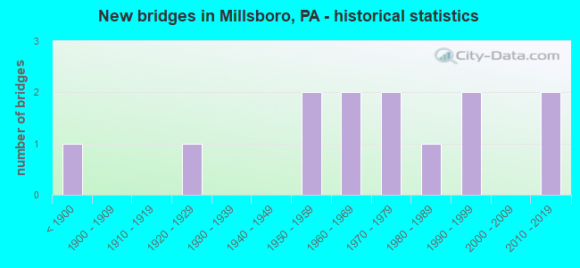
- New bridges - historical statistics
- 1Before 1900
- 11920-1929
- 21950-1959
- 21960-1969
- 21970-1979
- 11980-1989
- 21990-1999
- 22010-2019

- Reconstructed bridges - Historical Statistics
- 21990-1999
- 32000-2009
- 12010-2019
- 12020-2022


- Bridge Condition - Deck
- 25.0%Very good
- 50.0%Good
- 25.0%Satisfactory

- Bridge Condition - Superstructure
- 7.7%Excellent
- 38.5%Very good
- 15.4%Good
- 23.1%Satisfactory
- 7.7%Fair
- 7.7%Poor

- Bridge Condition - Substructure
- 7.7%Very good
- 61.5%Good
- 7.7%Satisfactory
- 23.1%Fair

- Bridge Condition - Channel
- 10.0%Very good
- 40.0%Good
- 30.0%Satisfactory
- 20.0%Fair
Find on map >> Show street view
Structure Number: 7782, Location: BON AIRE (Lat: 40.879853, Lng: -79.897525), Route carried "on" structure: State highway 8, Year Built: 1960, Year Reconstructed: 2006, Status: Open, Structure Length: 2.87m (9.42ft), Average Daily Traffic: 11,752 (year 2022), Truck Traffic: 5%, Average Future Daily Traffic: 15,620 (year 2032), Design Load: HS 20, Features Intersected: SR0422 EB&WB
Minimum Vertical Clearance: 30+ m (98+ ft), Kilometerpoint: 24.584, Lanes on structure: 3, Lanes under structure: 6, Base Highway Network: Yes, Owner: State Highway Agency, Approaching Roadway Width: 23.2m (76.1ft), Skew: 21 degrees, Material/Design: Prestressed concrete, Design/Construction: Box Beam or Girders - Single/Spread, Number Of Spans In Main Unit: 1, Length of Maximum Span: 27.7m (90.9ft), Curb or Sidewalk Widths: Left: 1.5m (4.9ft), Right: 1.5m (4.9ft), Curb-To-Curb Width: 23.2m (76.1ft), Out-to-Out Width: 27.0m (88.6ft)
Condition: Deck: Good, Superstructure: Very good, Substructure: Good, Operating Rating: 89.8 metric tons, Method Used To Determine Operating Rating: Load Factor (LF), Inventory Rating: 33.6 metric tons, Method Used To Determine Inventory Rating: Load Factor (LF), Structural Evaluation: Better than present minimum criteria, Deck Geometry: Superior to present desirable criteria, Underclear: High priority of replacement, Approach Roadway Alignment: Equal to present desirable criteria, Length Of Structure Improvement: 5.80m (19.03ft), Designated Inspection Frequency: Every 24 months, Inspection Date: March 2020, Bridge Improvement Cost: $424,000, Roadway Improvement Cost: $1,248,000, Total Project Cost: $5,721,000, Deck Structure Type: Concrete Cast-file-Place, Wearing Surface/Protective System: Wearing Surface: Monolithic Concrete, Deck Protection: Epoxy Coated Reinforcing
Find on map >> Show street view
Structure Number: 8474, Location: 0.7 MILE NORTH OF TR 22 (Lat: 40.473589, Lng: -78.763469), Route carried "on" structure: US 219, Year Built: 1975, Year Reconstructed: 2006, Status: Open, Structure Length: 7.25m (23.79ft), Average Daily Traffic: 4,251 (year 2020), Truck Traffic: 13%, Average Future Daily Traffic: 5,378 (year 2032), Design Load: HS 20, Features Intersected: SR 3034
Minimum Vertical Clearance: 30+ m (98+ ft), Kilometerpoint: 30.111, Lanes on structure: 2, Lanes under structure: 2, Base Highway Network: Yes, Owner: State Highway Agency, Approaching Roadway Width: 11.6m (38.1ft), Skew: 11 degrees, Material/Design: Prestressed concrete, Design/Construction: Stringer/Multi-beam, Number Of Spans In Main Unit: 3, Length of Maximum Span: 23.5m (77.1ft), Curb or Sidewalk Widths: Left: 0.2m (0.7ft), Right: 0.2m (0.7ft), Curb-To-Curb Width: 12.8m (42.0ft), Out-to-Out Width: 13.9m (45.6ft)
Condition: Deck: Good, Superstructure: Satisfactory, Substructure: Good, Operating Rating: 83.5 metric tons, Method Used To Determine Operating Rating: Load Factor (LF), Inventory Rating: 32.7 metric tons, Method Used To Determine Inventory Rating: Load Factor (LF), Structural Evaluation: Equal to present minimum criteria, Deck Geometry: Equal to present desirable criteria, Underclear: Superior to present desirable criteria, Approach Roadway Alignment: Equal to present desirable criteria, Length Of Structure Improvement: 8.20m (26.90ft), Designated Inspection Frequency: Every 24 months, Inspection Date: May 2021, Deck Structure Type: Concrete Cast-file-Place, Wearing Surface/Protective System: Wearing Surface: Latex Concrete, Deck Protection: Epoxy Coated Reinforcing
Find on map >> Show street view
Structure Number: 18237, Location: JEFFERSON TOWNSHIP (Lat: 39.980886, Lng: -80.024142), Route carried "on" structure: State highway , Year Built: 1991, Status: Open, Structure Length: 5.94m (19.49ft), Average Daily Traffic: 484 (year 2022), Truck Traffic: 2%, Average Future Daily Traffic: 2,422 (year 2032), Design Load: HS 25 or greater, Features Intersected: TENMILE CREEK, Facility Carried by Structure: SR 1029
Minimum Vertical Clearance: 30+ m (98+ ft), Kilometerpoint: 0.000, Lanes on structure: 2, Owner: State Highway Agency, Approaching Roadway Width: 10.4m (34.1ft), Material/Design: Prestressed concrete continuous, Design/Construction: Box Beam or Girders - Multiple, Number Of Spans In Main Unit: 2, Length of Maximum Span: 29.9m (98.1ft), Curb-To-Curb Width: 11.3m (37.1ft), Out-to-Out Width: 12.3m (40.4ft)
Condition: Deck: Satisfactory, Superstructure: Satisfactory, Substructure: Good, Channel: Good, Inventory Rating: 41.7 metric tons, Method Used To Determine Inventory Rating: Load Factor (LF), Structural Evaluation: Equal to present minimum criteria, Deck Geometry: Better than present minimum criteria, Waterway Adequacy: Equal to present desirable criteria, Approach Roadway Alignment: Equal to present desirable criteria, Length Of Structure Improvement: 7.50m (24.61ft), Designated Inspection Frequency: Every 48 months, Underwater Inspection Frequency: Every 60 months, Inspection Date: September 2018, Underwater Inspection Date: November 2019, Bridge Improvement Cost: $251,000, Roadway Improvement Cost: $740,000, Total Project Cost: $3,391,000, Deck Structure Type: Concrete Cast-file-Place, Wearing Surface/Protective System: Wearing Surface: Monolithic Concrete, Deck Protection: Epoxy Coated Reinforcing
Find on map >> Show street view
Structure Number: 20315, Location: 50 FT. E OF SR 235 INTER (Lat: 40.613567, Lng: -77.184975), Route carried "on" structure: ServiceCity street , Year Built: 1950, Year Reconstructed: 2011, Status: Open, Structure Length: 0.94m (3.08ft), Average Daily Traffic: 50 (year 2019), Truck Traffic: 5%, Average Future Daily Traffic: 63 (year 2039), Design Load: HL 93, Features Intersected: COCOLAMUS CREEK, Facility Carried by Structure: T-475 MEISER RD
Minimum Vertical Clearance: 30+ m (98+ ft), Kilometerpoint: 0.000, Lanes on structure: 1, Owner: Town or Township Highway Agency, Approaching Roadway Width: 5.2m (17.1ft), Material/Design: Steel, Design/Construction: Stringer/Multi-beam, Number Of Spans In Main Unit: 1, Length of Maximum Span: 9.1m (29.9ft), Curb-To-Curb Width: 5.5m (18.0ft), Out-to-Out Width: 5.5m (18.0ft)
Condition: Deck: Good, Superstructure: Very good, Substructure: Good, Channel: Satisfactory, Operating Rating: 74.4 metric tons, Method Used To Determine Operating Rating: Load Factor (LF), Inventory Rating: 44.5 metric tons, Method Used To Determine Inventory Rating: Load Factor (LF), Structural Evaluation: Better than present minimum criteria, Deck Geometry: Meets minimum limits, Waterway Adequacy: Equal to present minimum criteria, Approach Roadway Alignment: Better than present minimum criteria, Length Of Structure Improvement: 1.20m (3.94ft), Designated Inspection Frequency: Every 24 months, Inspection Date: November 2021, Bridge Improvement Cost: $47,000, Roadway Improvement Cost: $264,000, Total Project Cost: $632,000, Deck Structure Type: Open Grating
Find on map >> Show street view
Structure Number: 20603, Location: CLIFTON TWP WAYNE CO LINE (Lat: 41.236617, Lng: -75.500644), Route carried "on" structure: State highway 435, Year Built: 1927, Year Reconstructed: 1990, Status: Open, Structure Length: 1.16m (3.81ft), Average Daily Traffic: 6,587 (year 2022), Truck Traffic: 18%, Average Future Daily Traffic: 8,924 (year 2032), Design Load: H 20, Features Intersected: LEHIGH RIVER
Minimum Vertical Clearance: 30+ m (98+ ft), Kilometerpoint: 0.000, Lanes on structure: 2, Owner: State Highway Agency, Approaching Roadway Width: 14.6m (47.9ft), Skew: 1 degrees, Material/Design: Concrete, Design/Construction: Tee Beam, Number Of Spans In Main Unit: 1, Length of Maximum Span: 11.0m (36.1ft), Out-to-Out Width: 19.9m (65.3ft)
Condition: Superstructure: Fair, Substructure: Fair, Channel: Good, Operating Rating: 49.9 metric tons, Method Used To Determine Operating Rating: Field evaluation and documented engineering judgment, Inventory Rating: 32.7 metric tons, Method Used To Determine Inventory Rating: Field evaluation and documented engineering judgment, Structural Evaluation: Somewhat better than minimum adequacy, Waterway Adequacy: Equal to present desirable criteria, Approach Roadway Alignment: Equal to present desirable criteria, Length Of Structure Improvement: 1.80m (5.91ft), Designated Inspection Frequency: Every 24 months, Inspection Date: May 2020, Bridge Improvement Cost: $5,000, Roadway Improvement Cost: $15,000, Total Project Cost: $69,000
Find on map >> Show street view
Structure Number: 20648, Location: SCOTT TWP .2 M W I-81 (Lat: 41.554744, Lng: -75.658369), Route carried "on" structure: State highway 524, Year Built: 1986, Status: Open, Structure Length: 0.67m (2.20ft), Average Daily Traffic: 1,194 (year 2020), Truck Traffic: 9%, Average Future Daily Traffic: 1,424 (year 2032), Design Load: HS 25 or greater, Features Intersected: KENNEDY CREEK
Minimum Vertical Clearance: 30+ m (98+ ft), Kilometerpoint: 4.408, Lanes on structure: 2, Owner: State Highway Agency, Approaching Roadway Width: 6.4m (21.0ft), Skew: 4 degrees, Material/Design: Prestressed concrete, Design/Construction: Box Beam or Girders - Multiple, Number Of Spans In Main Unit: 1, Length of Maximum Span: 6.4m (21.0ft), Curb or Sidewalk Widths: Left: 0.2m (0.7ft), Right: 0.2m (0.7ft), Curb-To-Curb Width: 10.5m (34.4ft), Out-to-Out Width: 11.6m (38.1ft)
Condition: Deck: Satisfactory, Superstructure: Good, Substructure: Good, Channel: Satisfactory, Inventory Rating: 99.8 metric tons, Method Used To Determine Inventory Rating: Load Factor (LF), Structural Evaluation: Better than present minimum criteria, Deck Geometry: Equal to present minimum criteria, Waterway Adequacy: Equal to present desirable criteria, Approach Roadway Alignment: Equal to present desirable criteria, Length Of Structure Improvement: 1.30m (4.27ft), Designated Inspection Frequency: Every 48 months, Inspection Date: August 2020, Deck Structure Type: Concrete Cast-file-Place, Wearing Surface/Protective System: Wearing Surface: Monolithic Concrete, Deck Protection: Epoxy Coated Reinforcing
Find on map >> Show street view
Structure Number: 21958, Location: 2000 FT SE OF T-351 (Lat: 39.724967, Lng: -76.183631), Route carried "on" structure: City street , Year Built: 1972, Year Reconstructed: 2020, Status: Open, Structure Length: 2.26m (7.41ft), Average Daily Traffic: 225 (year 2012), Truck Traffic: 10%, Average Future Daily Traffic: 300 (year 2032), Design Load: HL 93, Features Intersected: CONOWINGO CREEK, Facility Carried by Structure: OLD MILL RD
Minimum Vertical Clearance: 30+ m (98+ ft), Kilometerpoint: 0.000, Lanes on structure: 2, Owner: County Highway Agency, Approaching Roadway Width: 9.8m (32.2ft), Material/Design: Prestressed concrete, Design/Construction: Box Beam or Girders - Single/Spread, Number Of Spans In Main Unit: 1, Length of Maximum Span: 21.9m (71.9ft), Curb-To-Curb Width: 8.8m (28.9ft), Out-to-Out Width: 9.8m (32.2ft)
Condition: Deck: Very good, Superstructure: Very good, Substructure: Satisfactory, Channel: Fair, Operating Rating: 45.4 metric tons, Method Used To Determine Operating Rating: Load Factor (LF), Inventory Rating: 3.6 metric tons, Method Used To Determine Inventory Rating: Load Factor (LF), Structural Evaluation: High priority of corrective action, Deck Geometry: Equal to present minimum criteria, Waterway Adequacy: Equal to present desirable criteria, Approach Roadway Alignment: Equal to present desirable criteria, Length Of Structure Improvement: 2.30m (7.55ft), Designated Inspection Frequency: Every 24 months, Inspection Date: December 2020, Wearing Surface/Protective System: Wearing Surface: Monolithic Concrete
Find on map >> Show street view
Structure Number: 22011, Location: 450 FT SOUTH OF SR 30 (Lat: 40.001156, Lng: -76.091989), Route carried "on" structure: City street , Year Built: 1996, Status: Open, Structure Length: 4.51m (14.80ft), Average Daily Traffic: 465 (year 2012), Truck Traffic: 10%, Average Future Daily Traffic: 615 (year 2032), Design Load: HS 25 or greater, Features Intersected: AMTRAK, Facility Carried by Structure: T-791 McILVAINE RD
Minimum Vertical Clearance: 30+ m (98+ ft), Kilometerpoint: 0.000, Lanes on structure: 2, Owner: Town or Township Highway Agency, Approaching Roadway Width: 8.5m (27.9ft), Skew: 2 degrees, Material/Design: Prestressed concrete continuous, Design/Construction: Box Beam or Girders - Single/Spread, Number Of Spans In Main Unit: 3, Length of Maximum Span: 19.5m (64.0ft), Curb or Sidewalk Widths: Left: 0.2m (0.7ft), Right: 0.2m (0.7ft), Curb-To-Curb Width: 8.5m (27.9ft), Out-to-Out Width: 9.6m (31.5ft)
Condition: Deck: Good, Superstructure: Good, Substructure: Good, Operating Rating: 76.2 metric tons, Method Used To Determine Operating Rating: Load Factor (LF), Inventory Rating: 39.9 metric tons, Method Used To Determine Inventory Rating: Load Factor (LF), Structural Evaluation: Better than present minimum criteria, Deck Geometry: Somewhat better than minimum adequacy, Underclear: High priority of corrective action, Approach Roadway Alignment: Equal to present desirable criteria, Length Of Structure Improvement: 5.50m (18.04ft), Designated Inspection Frequency: Every 24 months, Inspection Date: October 2019, Deck Structure Type: Concrete Cast-file-Place, Wearing Surface/Protective System: Wearing Surface: Bituminous, Deck Protection: Epoxy Coated Reinforcing
Find on map >> Show street view
Structure Number: 28823, Location: AT ZUCKSVILLE (Lat: 40.717322, Lng: -75.245272), Route carried "on" structure: City street , Year Built: 1969, Status: Open, Structure Length: 3.23m (10.60ft), Average Daily Traffic: 200 (year 2010), Truck Traffic: 1%, Average Future Daily Traffic: 250 (year 2030), Design Load: HS 20, Features Intersected: BUSHKILL CREEK, Facility Carried by Structure: STOCKER MILL ROAD
Minimum Vertical Clearance: 30+ m (98+ ft), Kilometerpoint: 0.000, Lanes on structure: 2, Owner: County Highway Agency, Approaching Roadway Width: 9.8m (32.2ft), Material/Design: Prestressed concrete, Design/Construction: Box Beam or Girders - Multiple, Number Of Spans In Main Unit: 2, Length of Maximum Span: 15.8m (51.8ft), Curb or Sidewalk Widths: Left: 1.6m (5.2ft), Right: 0.4m (1.3ft), Curb-To-Curb Width: 9.8m (32.2ft), Out-to-Out Width: 12.7m (41.7ft)
Condition: Deck: Good, Superstructure: Satisfactory, Substructure: Fair, Channel: Satisfactory, Operating Rating: 64.4 metric tons, Method Used To Determine Operating Rating: Load Factor (LF), Inventory Rating: 38.1 metric tons, Method Used To Determine Inventory Rating: Load Factor (LF), Structural Evaluation: Somewhat better than minimum adequacy, Deck Geometry: Better than present minimum criteria, Waterway Adequacy: Equal to present minimum criteria, Approach Roadway Alignment: Equal to present desirable criteria, Length Of Structure Improvement: 4.10m (13.45ft), Designated Inspection Frequency: Every 24 months, Inspection Date: May 2020, Deck Structure Type: Concrete Cast-file-Place, Wearing Surface/Protective System: Wearing Surface: Latex Concrete
Find on map >> Show street view
Structure Number: 30881, Location: NORTH OF RAUSCHS (Lat: 40.668292, Lng: -75.995633), Route carried "on" structure: City street , Year Built: 1956, Year Reconstructed: 2018, Status: Open, Structure Length: 4.85m (15.91ft), Average Daily Traffic: 200 (year 1980), Average Future Daily Traffic: 221 (year 2037), Design Load: HL 93, Features Intersected: LITTLE SCHUYLKILL RIVER, Facility Carried by Structure: WILD TURKEY LN
Minimum Vertical Clearance: 30+ m (98+ ft), Kilometerpoint: 0.000, Lanes on structure: 2, Owner: County Highway Agency, Approaching Roadway Width: 6.1m (20.0ft), Skew: 1 degrees, Material/Design: Prestressed concrete, Design/Construction: Box Beam or Girders - Single/Spread, Number Of Spans In Main Unit: 3, Length of Maximum Span: 14.6m (47.9ft), Curb-To-Curb Width: 7.3m (24.0ft), Out-to-Out Width: 7.5m (24.6ft)
Condition: Deck: Very good, Superstructure: Excellent, Substructure: Good, Channel: Good, Operating Rating: 60.8 metric tons, Method Used To Determine Operating Rating: Load and Resistance Factor (LRFR), Inventory Rating: 39.9 metric tons, Method Used To Determine Inventory Rating: Load and Resistance Factor (LRFR), Structural Evaluation: Better than present minimum criteria, Deck Geometry: Somewhat better than minimum adequacy, Waterway Adequacy: Equal to present desirable criteria, Approach Roadway Alignment: Equal to present desirable criteria, Length Of Structure Improvement: 4.80m (15.75ft), Designated Inspection Frequency: Every 24 months, Inspection Date: September 2020, Bridge Improvement Cost: $11,000, Roadway Improvement Cost: $51,000, Total Project Cost: $151,000, Wearing Surface/Protective System: Wearing Surface: Monolithic Concrete, Deck Protection: Epoxy Coated Reinforcing
Find on map >> Show street view
Structure Number: 35267, Location: 400' WEST OF SR 4035 (Lat: 40.259047, Lng: -80.377700), Route carried "on" structure: City street T486, Year Built: 1887, Year Reconstructed: 2001, Status: Posted for load, Structure Length: 1.16m (3.81ft), Average Daily Traffic: 20 (year 1990), Average Future Daily Traffic: 20 (year 2000), Design Load: HS 20, Features Intersected: CROSS CREEK, Facility Carried by Structure: WILSON,LOWTON BR
Minimum Vertical Clearance: 30+ m (98+ ft), Kilometerpoint: 0.000, Lanes on structure: 1, Base Highway Network: Yes, Owner: County Highway Agency, Approaching Roadway Width: 3.0m (9.8ft), Material/Design: Steel, Design/Construction: Girder and Floorbeam System, Number Of Spans In Main Unit: 1, Length of Maximum Span: 10.1m (33.1ft), Curb or Sidewalk Widths: Left: 0.2m (0.7ft), Right: 0.2m (0.7ft), Curb-To-Curb Width: 3.6m (11.8ft), Out-to-Out Width: 4.6m (15.1ft)
Condition: Deck: Satisfactory, Superstructure: Poor, Substructure: Fair, Channel: Fair, Operating Rating: 10.9 metric tons, Method Used To Determine Operating Rating: Allowable Stress (AS), Inventory Rating: 8.2 metric tons, Method Used To Determine Inventory Rating: Allowable Stress (AS), Structural Evaluation: High priority of corrective action, Deck Geometry: High priority of corrective action, Waterway Adequacy: Better than present minimum criteria, Approach Roadway Alignment: Equal to present minimum criteria, Bridge Posting: Required (Relationship of Operating Rating to Maximum Legal Load: > 39.9% below), Length Of Structure Improvement: 1.90m (6.23ft), Designated Inspection Frequency: Every 24 months, Critical Feature Inspection Frequency: Every 12 months, Other Special Inspection Frequency: Every 12 months, Inspection Date: July 2021, Critical Feature Inspection Date: July 2021, Other Special Inspection Date: July 2021, Bridge Improvement Cost: $4,000, Roadway Improvement Cost: $11,000, Total Project Cost: $52,000, Deck Structure Type: Wood or Timber, Wearing Surface/Protective System: Wearing Surface: Wood or Timber
Find on map >> Show street view
Structure Number: 46451, Location: 0.1 mi S of SR 0088 (Lat: 39.984142, Lng: -80.010464), Route carried "on" structure: State highway , Year Built: 2010, Status: Open, Structure Length: 2.16m (7.09ft), Average Daily Traffic: 1,317 (year 2022), Truck Traffic: 6%, Average Future Daily Traffic: 2,338 (year 2032), Design Load: HL 93, Features Intersected: Black Dog Hollow Run, Facility Carried by Structure: SR 2039
Minimum Vertical Clearance: 30+ m (98+ ft), Kilometerpoint: 3.252, Lanes on structure: 2, Owner: State Highway Agency, Approaching Roadway Width: 6.7m (22.0ft), Skew: 1 degrees, Material/Design: Prestressed concrete, Design/Construction: Box Beam or Girders - Single/Spread, Number Of Spans In Main Unit: 1, Length of Maximum Span: 20.7m (67.9ft), Curb or Sidewalk Widths: Left: 0.1m (0.3ft), Right: 0.1m (0.3ft), Curb-To-Curb Width: 11.8m (38.7ft), Out-to-Out Width: 12.8m (42.0ft)
Condition: Deck: Very good, Superstructure: Very good, Substructure: Very good, Channel: Very good, Operating Rating: 66.2 metric tons, Method Used To Determine Operating Rating: Load and Resistance Factor (LRFR), Inventory Rating: 45.4 metric tons, Method Used To Determine Inventory Rating: Load and Resistance Factor (LRFR), Structural Evaluation: Equal to present desirable criteria, Deck Geometry: Equal to present minimum criteria, Waterway Adequacy: Superior to present desirable criteria, Approach Roadway Alignment: Better than present minimum criteria, Designated Inspection Frequency: Every 48 months, Inspection Date: May 2018, Deck Structure Type: Concrete Cast-file-Place, Wearing Surface/Protective System: Wearing Surface: Monolithic Concrete, Deck Protection: Epoxy Coated Reinforcing
Find on map >> Show street view
Structure Number: 46754, Location: 3.3 mi N from SR 0188 (Lat: 39.983322, Lng: -80.010511), Route carried "on" structure: State highway 88, Year Built: 2011, Status: Open, Structure Length: 11.77m (38.62ft), Average Daily Traffic: 3,104 (year 2021), Truck Traffic: 14%, Average Future Daily Traffic: 7,190 (year 2032), Design Load: HL 93, Features Intersected: Ten Mile Creek
Minimum Vertical Clearance: 30+ m (98+ ft), Kilometerpoint: 33.207, Lanes on structure: 2, Base Highway Network: Yes, Owner: State Highway Agency, Approaching Roadway Width: 10.4m (34.1ft), Skew: 4 degrees, Material/Design: Steel continuous, Design/Construction: Stringer/Multi-beam, Number Of Spans In Main Unit: 3, Length of Maximum Span: 52.7m (172.9ft), Curb or Sidewalk Widths: Left: 0.1m (0.3ft), Right: 2.1m (6.9ft), Curb-To-Curb Width: 11.6m (38.1ft), Out-to-Out Width: 15.1m (49.5ft)
Condition: Deck: Good, Superstructure: Very good, Substructure: Good, Channel: Good, Operating Rating: 54.8 metric tons, Method Used To Determine Operating Rating: Assigned ratings based on Load and Resistance Factor Design (LRFD) reported by rating factor (RF) using HL93 loadings, Inventory Rating: 39.2 metric tons, Method Used To Determine Inventory Rating: Assigned ratings based on Load and Resistance Factor Design (LRFD) reported by rating factor (RF) using HL93 loadings, Structural Evaluation: Better than present minimum criteria, Deck Geometry: Somewhat better than minimum adequacy, Waterway Adequacy: Superior to present desirable criteria, Approach Roadway Alignment: Equal to present desirable criteria, Designated Inspection Frequency: Every 48 months, Underwater Inspection Frequency: Every 60 months, Inspection Date: September 2020, Underwater Inspection Date: November 2020, Deck Structure Type: Concrete Cast-file-Place, Wearing Surface/Protective System: Wearing Surface: Monolithic Concrete, Deck Protection: Epoxy Coated Reinforcing