Bridge Statistics for Millsboro, Delaware (DE)
Condition, Traffic, Stress, Structural Evaluation, Project Costs
- National Bridge Inventory (NBI) Statistics
- 11Number of bridges
- 33ft / 10.1mTotal length
- $2,232,000Total costs
- 84,721Total average daily traffic
- 7,340Total average daily truck traffic
- 105,323Total future (year 2042) average daily traffic
- National Bridge Inventory (NBI) Registered Bridges for Millsboro
- No street view available for this location
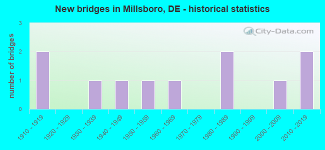
- New bridges - historical statistics
- 21910-1919
- 11930-1939
- 11940-1949
- 11950-1959
- 11960-1969
- 21980-1989
- 12000-2009
- 22010-2019

- Reconstructed bridges - Historical Statistics
- 11960-1969
- 01970-1979
- 11980-1989


- Bridge Condition - Deck
- 25.0%Very good
- 50.0%Good
- 25.0%Satisfactory

- Bridge Condition - Superstructure
- 25.0%Very good
- 25.0%Good
- 50.0%Satisfactory

- Bridge Condition - Substructure
- 25.0%Good
- 75.0%Satisfactory

- Bridge Condition - Channel
- 36.4%Very good
- 36.4%Good
- 18.2%Satisfactory
- 9.1%Fair

- Bridge Condition - Culverts
- 42.9%Good
- 42.9%Satisfactory
- 14.3%Fair
Find on map >> Show street view
Structure Number: 3504 113, Location: NORTH OF DAGSBORO (Lat: 38.562078, Lng: -75.274636), Route carried "on" structure: US 113, Year Built: 1911, Year Reconstructed: 1965, Status: Open, Structure Length: 0.88m (2.89ft), Average Daily Traffic: 21,126 (year 2020), Truck Traffic: 7%, Average Future Daily Traffic: 26,258 (year 2043), Features Intersected: WARTONS BRANCH
Minimum Vertical Clearance: 30.48m (100.00ft), Kilometerpoint: 13.181, Lanes on structure: 4, Base Highway Network: Yes, Owner: State Highway Agency, Approaching Roadway Width: 22.9m (75.1ft), Material/Design: Concrete, Design/Construction: Culvert, Number Of Spans In Main Unit: 2, Length of Maximum Span: 4.0m (13.1ft), Curb-To-Curb Width: 22.8m (74.8ft), Out-to-Out Width: 31.7m (104.0ft)
Condition: Channel: Good, Culverts: Satisfactory, Operating Rating: 31.4 metric tons, Method Used To Determine Operating Rating: Load and Resistance Factor Rating (LRFR) rating reported by rating factor(RF) method using HL-93 loadings, Inventory Rating: 24.0 metric tons, Method Used To Determine Inventory Rating: Load and Resistance Factor Rating (LRFR) rating reported by rating factor(RF) method using HL-93 loadings, Structural Evaluation: Somewhat better than minimum adequacy, Deck Geometry: Superior to present desirable criteria, Waterway Adequacy: Equal to present minimum criteria, Approach Roadway Alignment: Equal to present desirable criteria, Designated Inspection Frequency: Every 24 months, Inspection Date: April 2021, Total Project Cost: $131,000
Find on map >> Show street view
Structure Number: 3508 113, Location: BETTS POND (Lat: 38.595225, Lng: -75.312344), Route carried "on" structure: US 113, Year Built: 1912, Year Reconstructed: 1989, Status: Open, Structure Length: 0.68m (2.23ft), Average Daily Traffic: 21,173 (year 2020), Truck Traffic: 7%, Average Future Daily Traffic: 26,316 (year 2043), Features Intersected: BETTS POND
Minimum Vertical Clearance: 30.48m (100.00ft), Kilometerpoint: 18.314, Lanes on structure: 4, Base Highway Network: Yes, Owner: State Highway Agency, Approaching Roadway Width: 22.6m (74.1ft), Material/Design: Concrete, Design/Construction: Slab, Number Of Spans In Main Unit: 1, Length of Maximum Span: 6.5m (21.3ft), Curb-To-Curb Width: 31.8m (104.3ft), Out-to-Out Width: 31.8m (104.3ft)
Condition: Deck: Satisfactory, Superstructure: Satisfactory, Substructure: Satisfactory, Channel: Very good, Operating Rating: 57.7 metric tons, Method Used To Determine Operating Rating: Load and Resistance Factor Rating (LRFR) rating reported by rating factor(RF) method using HL-93 loadings, Inventory Rating: 44.7 metric tons, Method Used To Determine Inventory Rating: Load and Resistance Factor Rating (LRFR) rating reported by rating factor(RF) method using HL-93 loadings, Structural Evaluation: Equal to present minimum criteria, Deck Geometry: Superior to present desirable criteria, Waterway Adequacy: Equal to present minimum criteria, Approach Roadway Alignment: Equal to present desirable criteria, Designated Inspection Frequency: Every 24 months, Underwater Inspection Frequency: Every 48 months, Inspection Date: September 2021, Underwater Inspection Date: October 2019, Total Project Cost: $114,000, Deck Structure Type: Concrete Cast-file-Place, Wearing Surface/Protective System: Wearing Surface: Bituminous
Find on map >> Show street view
Structure Number: 3514 024, Location: N. MILLSBORO LIMITS (Lat: 38.594486, Lng: -75.290958), Route carried "on" structure: State highway 24, Year Built: 1981, Status: Open, Structure Length: 2.27m (7.45ft), Average Daily Traffic: 16,930 (year 2020), Truck Traffic: 12%, Average Future Daily Traffic: 21,042 (year 2043), Design Load: HS 20, Features Intersected: INDIAN RIVER, Facility Carried by Structure: JOHN J WILLIAMS HY
Minimum Vertical Clearance: 30.48m (100.00ft), Kilometerpoint: 41.763, Lanes on structure: 2, Owner: State Highway Agency, Approaching Roadway Width: 14.0m (45.9ft), Material/Design: Steel, Design/Construction: Stringer/Multi-beam, Number Of Spans In Main Unit: 1, Length of Maximum Span: 21.3m (69.9ft), Curb or Sidewalk Widths: Left: 1.9m (6.2ft), Right: 1.9m (6.2ft), Curb-To-Curb Width: 14.0m (45.9ft), Out-to-Out Width: 18.3m (60.0ft)
Condition: Deck: Good, Superstructure: Satisfactory, Substructure: Satisfactory, Channel: Very good, Operating Rating: 66.1 metric tons, Method Used To Determine Operating Rating: Load and Resistance Factor Rating (LRFR) rating reported by rating factor(RF) method using HL-93 loadings, Inventory Rating: 50.9 metric tons, Method Used To Determine Inventory Rating: Load and Resistance Factor Rating (LRFR) rating reported by rating factor(RF) method using HL-93 loadings, Structural Evaluation: Equal to present minimum criteria, Deck Geometry: Superior to present desirable criteria, Waterway Adequacy: Equal to present minimum criteria, Approach Roadway Alignment: Equal to present desirable criteria, Designated Inspection Frequency: Every 24 months, Inspection Date: July 2021, Deck Structure Type: Concrete Cast-file-Place, Wearing Surface/Protective System: Wearing Surface: Monolithic Concrete, Deck Protection: Epoxy Coated Reinforcing
Find on map >> Show street view
Structure Number: 3523 334, Location: S/E OF MILLSBORO (Lat: 38.564264, Lng: -75.274103), Route carried "on" structure: County highway 334, Year Built: 1940, Status: Open, Structure Length: 0.85m (2.79ft), Average Daily Traffic: 10,577 (year 2019), Truck Traffic: 9%, Average Future Daily Traffic: 13,146 (year 2042), Design Load: H 15, Features Intersected: WHARTON'S BRANCH, Facility Carried by Structure: DAGSBORO RD
Minimum Vertical Clearance: 30.48m (100.00ft), Kilometerpoint: 3.090, Lanes on structure: 2, Base Highway Network: Yes, Owner: State Highway Agency, Approaching Roadway Width: 12.4m (40.7ft), Material/Design: Concrete, Design/Construction: Slab, Number Of Spans In Main Unit: 1, Length of Maximum Span: 7.3m (24.0ft), Curb-To-Curb Width: 11.6m (38.1ft), Out-to-Out Width: 12.5m (41.0ft)
Condition: Deck: Good, Superstructure: Good, Substructure: Good, Channel: Good, Operating Rating: 36.0 metric tons, Method Used To Determine Operating Rating: Load and Resistance Factor Rating (LRFR) rating reported by rating factor(RF) method using HL-93 loadings, Inventory Rating: 27.9 metric tons, Method Used To Determine Inventory Rating: Load and Resistance Factor Rating (LRFR) rating reported by rating factor(RF) method using HL-93 loadings, Structural Evaluation: Better than present minimum criteria, Deck Geometry: Somewhat better than minimum adequacy, Waterway Adequacy: Equal to present minimum criteria, Approach Roadway Alignment: Equal to present desirable criteria, Designated Inspection Frequency: Every 24 months, Inspection Date: September 2020, Bridge Improvement Cost: $800,000, Roadway Improvement Cost: $200,000, Total Project Cost: $1,000,000, Deck Structure Type: Concrete Cast-file-Place, Wearing Surface/Protective System: Wearing Surface: Bituminous
Find on map >> Show street view
Structure Number: 3524 083, Location: MILLSBORO (Lat: 38.579278, Lng: -75.286306), Route carried "on" structure: County highway 83, Year Built: 1980, Status: Open, Structure Length: 0.73m (2.40ft), Average Daily Traffic: 2,257 (year 2019), Truck Traffic: 11%, Average Future Daily Traffic: 2,831 (year 2043), Design Load: HS 20, Features Intersected: IRON BRANCH, Facility Carried by Structure: MITCHELL ST.
Minimum Vertical Clearance: 30.48m (100.00ft), Kilometerpoint: 0.338, Lanes on structure: 2, Owner: State Highway Agency, Approaching Roadway Width: 6.7m (22.0ft), Material/Design: Concrete, Design/Construction: Culvert, Number Of Spans In Main Unit: 3, Length of Maximum Span: 1.8m (5.9ft)
Condition: Channel: Satisfactory, Culverts: Good, Operating Rating: 54.4 metric tons, Method Used To Determine Operating Rating: Field evaluation and documented engineering judgment, Inventory Rating: 32.7 metric tons, Method Used To Determine Inventory Rating: Field evaluation and documented engineering judgment, Structural Evaluation: Better than present minimum criteria, Waterway Adequacy: Better than present minimum criteria, Approach Roadway Alignment: Equal to present desirable criteria, Designated Inspection Frequency: Every 24 months, Inspection Date: April 2021
Find on map >> Show street view
Structure Number: 3527 326, Location: NW OF MILLSBORO (Lat: 38.596189, Lng: -75.304581), Route carried "on" structure: County highway 326, Year Built: 2003, Status: Open, Structure Length: 0.72m (2.36ft), Average Daily Traffic: 3,914 (year 2020), Truck Traffic: 9%, Average Future Daily Traffic: 4,864 (year 2043), Design Load: HS 25 or greater, Features Intersected: BETTS POND, Facility Carried by Structure: THOMPSONVILLE RD.
Minimum Vertical Clearance: 30.48m (100.00ft), Kilometerpoint: 1.255, Lanes on structure: 2, Owner: State Highway Agency, Approaching Roadway Width: 6.7m (22.0ft), Material/Design: Concrete, Design/Construction: Culvert, Number Of Spans In Main Unit: 1, Length of Maximum Span: 7.2m (23.6ft), Curb-To-Curb Width: 8.5m (27.9ft), Out-to-Out Width: 9.1m (29.9ft)
Condition: Channel: Very good, Culverts: Satisfactory, Operating Rating: 53.1 metric tons, Method Used To Determine Operating Rating: Load and Resistance Factor Rating (LRFR) rating reported by rating factor(RF) method using HL-93 loadings, Inventory Rating: 41.1 metric tons, Method Used To Determine Inventory Rating: Load and Resistance Factor Rating (LRFR) rating reported by rating factor(RF) method using HL-93 loadings, Structural Evaluation: Equal to present minimum criteria, Deck Geometry: Meets minimum limits, Waterway Adequacy: Equal to present minimum criteria, Approach Roadway Alignment: Equal to present desirable criteria, Designated Inspection Frequency: Every 24 months, Inspection Date: July 2021, Bridge Improvement Cost: $332,000, Total Project Cost: $332,000, Deck Structure Type: Concrete Precast Panels, Wearing Surface/Protective System: Wearing Surface: Bituminous, Deck Protection: Epoxy Coated Reinforcing
Find on map >> Show street view
Structure Number: 3530 41, Location: WEST OF MILLSBORO (Lat: 38.588222, Lng: -75.326767), Route carried "on" structure: County highway 410, Year Built: 1957, Status: Open, Structure Length: 1.13m (3.71ft), Average Daily Traffic: 432 (year 2020), Truck Traffic: 13%, Average Future Daily Traffic: 536 (year 2043), Design Load: H 15, Features Intersected: INGRAM POND, Facility Carried by Structure: GODWIN SCHOOL RD.
Minimum Vertical Clearance: 30.48m (100.00ft), Kilometerpoint: 7.821, Lanes on structure: 2, Owner: State Highway Agency, Approaching Roadway Width: 6.6m (21.7ft), Material/Design: Concrete, Design/Construction: Culvert, Number Of Spans In Main Unit: 3, Length of Maximum Span: 3.7m (12.1ft), Curb-To-Curb Width: 7.4m (24.3ft), Out-to-Out Width: 7.9m (25.9ft)
Condition: Channel: Very good, Culverts: Fair, Operating Rating: 52.2 metric tons, Method Used To Determine Operating Rating: Load and Resistance Factor Rating (LRFR) rating reported by rating factor(RF) method using HL-93 loadings, Inventory Rating: 37.6 metric tons, Method Used To Determine Inventory Rating: Load and Resistance Factor Rating (LRFR) rating reported by rating factor(RF) method using HL-93 loadings, Structural Evaluation: Somewhat better than minimum adequacy, Deck Geometry: Meets minimum limits, Waterway Adequacy: Better than present minimum criteria, Approach Roadway Alignment: Equal to present desirable criteria, Designated Inspection Frequency: Every 24 months, Inspection Date: June 2021, Deck Structure Type: Concrete Cast-file-Place
Find on map >> Show street view
Structure Number: 3592 412, Location: WEST OF MILLSBORO (Lat: 38.569556, Lng: -75.338722), Route carried "on" structure: County highway 412, Year Built: 1965, Status: Open, Structure Length: 0.64m (2.10ft), Average Daily Traffic: 442 (year 2020), Truck Traffic: 6%, Average Future Daily Traffic: 549 (year 2043), Design Load: HS 20, Features Intersected: PHILLIPS DITCH, Facility Carried by Structure: LAKEVIEW RD.
Minimum Vertical Clearance: 30.48m (100.00ft), Kilometerpoint: 0.113, Lanes on structure: 2, Owner: State Highway Agency, Approaching Roadway Width: 6.2m (20.3ft), Skew: 4 degrees, Material/Design: Concrete, Design/Construction: Culvert, Number Of Spans In Main Unit: 3, Length of Maximum Span: 1.7m (5.6ft)
Condition: Channel: Satisfactory, Culverts: Satisfactory, Operating Rating: 54.4 metric tons, Method Used To Determine Operating Rating: Field evaluation and documented engineering judgment, Inventory Rating: 32.7 metric tons, Method Used To Determine Inventory Rating: Field evaluation and documented engineering judgment, Structural Evaluation: Equal to present minimum criteria, Waterway Adequacy: Better than present minimum criteria, Approach Roadway Alignment: Equal to present desirable criteria, Designated Inspection Frequency: Every 24 months, Underwater Inspection Frequency: Every 48 months, Inspection Date: May 2021, Underwater Inspection Date: May 2021
Find on map >> Show street view
Structure Number: 3593 412, Location: WEST OF MILLSBORO (Lat: 38.577303, Lng: -75.343375), Route carried "on" structure: County highway 412, Year Built: 2011, Status: Open, Structure Length: 0.64m (2.10ft), Average Daily Traffic: 422 (year 2020), Truck Traffic: 8%, Average Future Daily Traffic: 524 (year 2043), Design Load: HS 20, Features Intersected: SHOALS BRANCH, Facility Carried by Structure: LAKEVIEW RD.
Minimum Vertical Clearance: 30.48m (100.00ft), Kilometerpoint: 1.050, Lanes on structure: 2, Owner: State Highway Agency, Approaching Roadway Width: 5.6m (18.4ft), Skew: 2 degrees, Design/Construction: Culvert, Number Of Spans In Main Unit: 3, Length of Maximum Span: 2.0m (6.6ft)
Condition: Channel: Good, Culverts: Good, Operating Rating: 54.4 metric tons, Method Used To Determine Operating Rating: Field evaluation and documented engineering judgment, Inventory Rating: 32.7 metric tons, Method Used To Determine Inventory Rating: Field evaluation and documented engineering judgment, Structural Evaluation: Better than present minimum criteria, Waterway Adequacy: Better than present minimum criteria, Approach Roadway Alignment: Equal to present desirable criteria, Length Of Structure Improvement: 1.09m (3.58ft), Designated Inspection Frequency: Every 24 months, Inspection Date: August 2021, Bridge Improvement Cost: $218,000, Roadway Improvement Cost: $22,000, Total Project Cost: $240,000
Find on map >> Show street view
Structure Number: 3670 432, Location: N.W. OF MILLSBORO (Lat: 38.605664, Lng: -75.357981), Route carried "on" structure: County highway 432, Year Built: 2012, Status: Open, Structure Length: 0.80m (2.62ft), Average Daily Traffic: 1,417 (year 2019), Truck Traffic: 10%, Average Future Daily Traffic: 1,761 (year 2042), Design Load: HS 20, Features Intersected: SHEEP PEN DITCH, Facility Carried by Structure: STOCKLEY RD
Minimum Vertical Clearance: 30.48m (100.00ft), Kilometerpoint: 5.584, Lanes on structure: 2, Owner: State Highway Agency, Approaching Roadway Width: 6.4m (21.0ft), Material/Design: Concrete, Design/Construction: Culvert, Number Of Spans In Main Unit: 3, Length of Maximum Span: 1.8m (5.9ft)
Condition: Channel: Good, Culverts: Good, Operating Rating: 54.4 metric tons, Method Used To Determine Operating Rating: Field evaluation and documented engineering judgment, Inventory Rating: 32.7 metric tons, Method Used To Determine Inventory Rating: Field evaluation and documented engineering judgment, Structural Evaluation: Better than present minimum criteria, Waterway Adequacy: Better than present minimum criteria, Approach Roadway Alignment: Equal to present minimum criteria, Length Of Structure Improvement: 1.17m (3.84ft), Designated Inspection Frequency: Every 24 months, Inspection Date: September 2020, Bridge Improvement Cost: $282,000, Roadway Improvement Cost: $28,000, Total Project Cost: $310,000
Find on map >> Show street view
Structure Number: 3673 048, Location: NORTH OF MILLSBORO (Lat: 38.638583, Lng: -75.316028), Route carried "on" structure: County highway 48, Year Built: 1932, Status: Posted for load, Structure Length: 0.79m (2.59ft), Average Daily Traffic: 6,031 (year 2020), Truck Traffic: 9%, Average Future Daily Traffic: 7,496 (year 2043), Design Load: H 20, Features Intersected: MORRIS MILL POND, Facility Carried by Structure: ZOAR RD.
Minimum Vertical Clearance: 30.48m (100.00ft), Kilometerpoint: 6.808, Lanes on structure: 2, Owner: State Highway Agency, Approaching Roadway Width: 7.3m (24.0ft), Material/Design: Concrete, Design/Construction: Slab, Number Of Spans In Main Unit: 1, Length of Maximum Span: 7.3m (24.0ft), Curb-To-Curb Width: 7.3m (24.0ft), Out-to-Out Width: 8.2m (26.9ft)
Condition: Deck: Very good, Superstructure: Very good, Substructure: Satisfactory, Channel: Fair, Operating Rating: 30.5 metric tons, Method Used To Determine Operating Rating: Load and Resistance Factor Rating (LRFR) rating reported by rating factor(RF) method using HL-93 loadings, Inventory Rating: 23.7 metric tons, Method Used To Determine Inventory Rating: Load and Resistance Factor Rating (LRFR) rating reported by rating factor(RF) method using HL-93 loadings, Structural Evaluation: Somewhat better than minimum adequacy, Deck Geometry: High priority of replacement, Waterway Adequacy: Equal to present minimum criteria, Approach Roadway Alignment: Equal to present desirable criteria, Bridge Posting: Required (Relationship of Operating Rating to Maximum Legal Load: 10.0 - 19.9% below), Length Of Structure Improvement: 0.79m (2.59ft), Designated Inspection Frequency: Every 24 months, Inspection Date: June 2021, Bridge Improvement Cost: $70,000, Roadway Improvement Cost: $7,000, Total Project Cost: $105,000