Bridge Statistics for Milford, Delaware (DE)
Condition, Traffic, Stress, Structural Evaluation, Project Costs
- National Bridge Inventory (NBI) Statistics
- 35Number of bridges
- 295ft / 89.6mTotal length
- $2,306,000Total costs
- 302,078Total average daily traffic
- 30,889Total average daily truck traffic
- National Bridge Inventory (NBI) Registered Bridges for Milford
- No street view available for this location
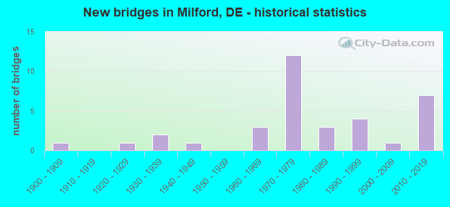
- New bridges - historical statistics
- 11900-1909
- 11920-1929
- 21930-1939
- 11940-1949
- 31960-1969
- 121970-1979
- 31980-1989
- 41990-1999
- 12000-2009
- 72010-2019
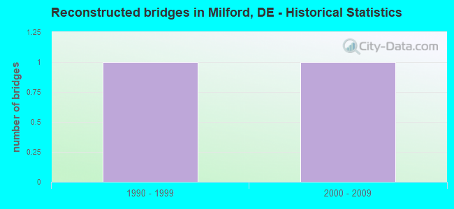
- Reconstructed bridges - Historical Statistics
- 11990-1999
- 12000-2009
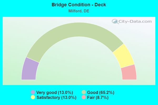
- Bridge Condition - Deck
- 13.0%Very good
- 65.2%Good
- 13.0%Satisfactory
- 8.7%Fair
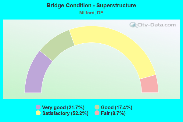
- Bridge Condition - Superstructure
- 21.7%Very good
- 17.4%Good
- 52.2%Satisfactory
- 8.7%Fair
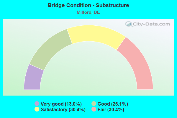
- Bridge Condition - Substructure
- 13.0%Very good
- 26.1%Good
- 30.4%Satisfactory
- 30.4%Fair
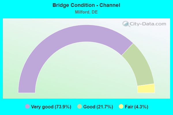
- Bridge Condition - Channel
- 73.9%Very good
- 21.7%Good
- 4.3%Fair
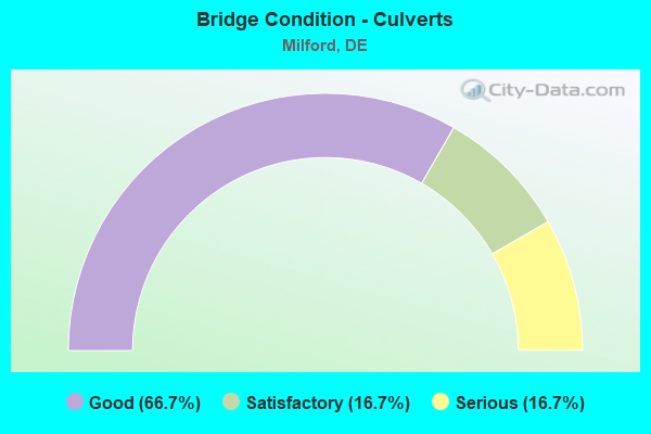
- Bridge Condition - Culverts
- 66.7%Good
- 16.7%Satisfactory
- 16.7%Serious
Find on map >> Show street view
Structure Number: 2008A008, Location: WEST MILFORD (Lat: 38.913142, Lng: -75.443986), Route carried "on" structure: US 113, Year Built: 1963, Status: Open, Structure Length: 1.66m (5.45ft), Average Daily Traffic: 14,969 (year 2019), Truck Traffic: 9%, Average Future Daily Traffic: 18,605 (year 2042), Design Load: HS 20, Features Intersected: HAVEN LAKE
Minimum Vertical Clearance: 30.48m (100.00ft), Kilometerpoint: 50.710, Lanes on structure: 2, Base Highway Network: Yes, Owner: State Highway Agency, Approaching Roadway Width: 11.0m (36.1ft), Material/Design: Steel, Design/Construction: Stringer/Multi-beam, Number Of Spans In Main Unit: 1, Length of Maximum Span: 14.7m (48.2ft), Curb-To-Curb Width: 11.0m (36.1ft), Out-to-Out Width: 13.2m (43.3ft)
Condition: Deck: Good, Superstructure: Satisfactory, Substructure: Good, Channel: Very good, Operating Rating: 72.6 metric tons, Method Used To Determine Operating Rating: Load and Resistance Factor Rating (LRFR) rating reported by rating factor(RF) method using HL-93 loadings, Inventory Rating: 41.1 metric tons, Method Used To Determine Inventory Rating: Load and Resistance Factor Rating (LRFR) rating reported by rating factor(RF) method using HL-93 loadings, Structural Evaluation: Equal to present minimum criteria, Deck Geometry: Equal to present minimum criteria, Waterway Adequacy: Equal to present desirable criteria, Approach Roadway Alignment: Equal to present desirable criteria, Designated Inspection Frequency: Every 24 months, Inspection Date: August 2020, Deck Structure Type: Concrete Cast-file-Place, Wearing Surface/Protective System: Wearing Surface: Latex Concrete
Find on map >> Show street view
Structure Number: 2008B008, Location: WEST MILFORD (Lat: 38.913139, Lng: -75.443717), Route carried "on" structure: US 113, Year Built: 1963, Status: Open, Structure Length: 2.26m (7.41ft), Average Daily Traffic: 14,969 (year 2019), Truck Traffic: 9%, Average Future Daily Traffic: 18,605 (year 2042), Design Load: HS 20, Features Intersected: HAVEN LAKE
Minimum Vertical Clearance: 30.48m (100.00ft), Kilometerpoint: 0.016, Lanes on structure: 2, Base Highway Network: Yes, Owner: State Highway Agency, Approaching Roadway Width: 11.0m (36.1ft), Material/Design: Steel, Design/Construction: Stringer/Multi-beam, Number Of Spans In Main Unit: 1, Length of Maximum Span: 21.6m (70.9ft), Curb-To-Curb Width: 11.0m (36.1ft), Out-to-Out Width: 13.2m (43.3ft)
Condition: Deck: Good, Superstructure: Satisfactory, Substructure: Good, Channel: Very good, Operating Rating: 74.8 metric tons, Method Used To Determine Operating Rating: Load and Resistance Factor Rating (LRFR) rating reported by rating factor(RF) method using HL-93 loadings, Inventory Rating: 57.7 metric tons, Method Used To Determine Inventory Rating: Load and Resistance Factor Rating (LRFR) rating reported by rating factor(RF) method using HL-93 loadings, Structural Evaluation: Equal to present minimum criteria, Deck Geometry: Equal to present minimum criteria, Waterway Adequacy: Equal to present desirable criteria, Approach Roadway Alignment: Equal to present desirable criteria, Designated Inspection Frequency: Every 24 months, Inspection Date: August 2020, Deck Structure Type: Concrete Cast-file-Place, Wearing Surface/Protective System: Wearing Surface: Latex Concrete
Find on map >> Show street view
Structure Number: 2008D008, Location: SOUTH OF MILFORD (Lat: 38.942411, Lng: -75.427222), Route carried "on" structure: US 113, Year Built: 1968, Status: Open, Structure Length: 0.89m (2.92ft), Average Daily Traffic: 16,117 (year 2020), Truck Traffic: 7%, Average Future Daily Traffic: 20,032 (year 2043), Design Load: HS 20, Features Intersected: TUB MILL POND/SWAN CREEK
Minimum Vertical Clearance: 30.48m (100.00ft), Kilometerpoint: 3.750, Lanes on structure: 5, Base Highway Network: Yes, Owner: State Highway Agency, Approaching Roadway Width: 36.0m (118.1ft), Skew: 22 degrees, Material/Design: Concrete, Design/Construction: Culvert, Number Of Spans In Main Unit: 5, Length of Maximum Span: 1.3m (4.3ft)
Condition: Channel: Fair, Culverts: Satisfactory, Operating Rating: 54.4 metric tons, Method Used To Determine Operating Rating: Field evaluation and documented engineering judgment, Inventory Rating: 32.7 metric tons, Method Used To Determine Inventory Rating: Field evaluation and documented engineering judgment, Structural Evaluation: Equal to present minimum criteria, Waterway Adequacy: Equal to present minimum criteria, Approach Roadway Alignment: Equal to present desirable criteria, Designated Inspection Frequency: Every 24 months, Inspection Date: July 2021
Find on map >> Show street view
Structure Number: 2008J008, Location: JUST NORTH OF MILFORD (Lat: 38.937525, Lng: -75.427736), Route carried "on" structure: US 113, Year Built: 1971, Status: Open, Structure Length: 6.71m (22.01ft), Average Daily Traffic: 16,117 (year 2020), Truck Traffic: 7%, Average Future Daily Traffic: 20,032 (year 2043), Design Load: HS 20, Features Intersected: SR 1, MILFORD BYPASS, Facility Carried by Structure: N. DUPONT BLVD
Minimum Vertical Clearance: 30.48m (100.00ft), Kilometerpoint: 3.026, Lanes on structure: 1, Lanes under structure: 4, Base Highway Network: Yes, Owner: State Highway Agency, Approaching Roadway Width: 9.0m (29.5ft), Skew: 4 degrees, Material/Design: Steel continuous, Design/Construction: Stringer/Multi-beam, Number Of Spans In Main Unit: 2, Length of Maximum Span: 32.6m (107.0ft), Curb-To-Curb Width: 8.7m (28.5ft), Out-to-Out Width: 9.8m (32.2ft)
Condition: Deck: Good, Superstructure: Satisfactory, Substructure: Satisfactory, Operating Rating: 45.4 metric tons, Method Used To Determine Operating Rating: Load and Resistance Factor Rating (LRFR) rating reported by rating factor(RF) method using HL-93 loadings, Inventory Rating: 35.0 metric tons, Method Used To Determine Inventory Rating: Load and Resistance Factor Rating (LRFR) rating reported by rating factor(RF) method using HL-93 loadings, Structural Evaluation: Equal to present minimum criteria, Deck Geometry: Meets minimum limits, Underclear: Better than present minimum criteria, Approach Roadway Alignment: Equal to present desirable criteria, Designated Inspection Frequency: Every 24 months, Inspection Date: July 2021, Deck Structure Type: Concrete Cast-file-Place, Wearing Surface/Protective System: Wearing Surface: Monolithic Concrete
Find on map >> Show street view
Structure Number: 2013, Location: N. MILFORD CITY LIMITS (Lat: 38.942500, Lng: -75.426733), Route carried "on" structure: City street , Year Built: 2008, Status: Open, Structure Length: 1.28m (4.20ft), Average Daily Traffic: 557 (year 2019), Truck Traffic: 11%, Average Future Daily Traffic: 692 (year 2042), Design Load: HS 20, Features Intersected: SWAN CREEK, Facility Carried by Structure: BIG STONE BEACH RD
Minimum Vertical Clearance: 30.48m (100.00ft), Kilometerpoint: 0.161, Lanes on structure: 2, Owner: State Highway Agency, Approaching Roadway Width: 9.8m (32.2ft), Material/Design: Concrete, Design/Construction: Culvert, Number Of Spans In Main Unit: 2, Length of Maximum Span: 6.1m (20.0ft), Curb-To-Curb Width: 14.1m (46.3ft), Out-to-Out Width: 14.6m (47.9ft)
Condition: Channel: Very good, Culverts: Good, Operating Rating: 42.1 metric tons, Method Used To Determine Operating Rating: Load and Resistance Factor Rating (LRFR) rating reported by rating factor(RF) method using HL-93 loadings, Inventory Rating: 35.6 metric tons, Method Used To Determine Inventory Rating: Load and Resistance Factor Rating (LRFR) rating reported by rating factor(RF) method using HL-93 loadings, Structural Evaluation: Better than present minimum criteria, Deck Geometry: Superior to present desirable criteria, Waterway Adequacy: Equal to present desirable criteria, Approach Roadway Alignment: Equal to present desirable criteria, Designated Inspection Frequency: Every 24 months, Inspection Date: September 2020
Find on map >> Show street view
Structure Number: 2019A019, Location: NORTH OF MILFORD (Lat: 38.967622, Lng: -75.415544), Route carried "on" structure: County highway 19, Year Built: 1996, Status: Open, Structure Length: 0.98m (3.22ft), Average Daily Traffic: 1,702 (year 2019), Truck Traffic: 10%, Average Future Daily Traffic: 2,115 (year 2042), Design Load: HS 20, Features Intersected: FISHING BRANCH, Facility Carried by Structure: THOMPSONVILLE RD
Minimum Vertical Clearance: 30.48m (100.00ft), Kilometerpoint: 1.610, Lanes on structure: 2, Owner: State Highway Agency, Approaching Roadway Width: 6.2m (20.3ft), Material/Design: Prestressed concrete, Design/Construction: Box Beam or Girders - Multiple, Number Of Spans In Main Unit: 1, Length of Maximum Span: 8.5m (27.9ft), Curb-To-Curb Width: 10.4m (34.1ft), Out-to-Out Width: 11.2m (36.7ft)
Condition: Deck: Very good, Superstructure: Very good, Substructure: Good, Channel: Very good, Operating Rating: 50.9 metric tons, Method Used To Determine Operating Rating: Load and Resistance Factor Rating (LRFR) rating reported by rating factor(RF) method using HL-93 loadings, Inventory Rating: 40.2 metric tons, Method Used To Determine Inventory Rating: Load and Resistance Factor Rating (LRFR) rating reported by rating factor(RF) method using HL-93 loadings, Structural Evaluation: Better than present minimum criteria, Deck Geometry: Equal to present minimum criteria, Waterway Adequacy: Equal to present minimum criteria, Approach Roadway Alignment: Equal to present desirable criteria, Designated Inspection Frequency: Every 24 months, Inspection Date: September 2020, Deck Structure Type: Concrete Cast-file-Place, Wearing Surface/Protective System: Wearing Surface: Monolithic Concrete, Deck Protection: Epoxy Coated Reinforcing
Find on map >> Show street view
Structure Number: 2019B019, Location: NORTH OF MILFORD (Lat: 38.957250, Lng: -75.427889), Route carried "on" structure: State highway 19, Year Built: 2016, Status: Open, Structure Length: 7.02m (23.03ft), Average Daily Traffic: 1,722 (year 2019), Truck Traffic: 8%, Average Future Daily Traffic: 2,014 (year 2038), Design Load: HS 20, Features Intersected: SR1 / BAY RD, Facility Carried by Structure: THOMPSONVILLE RD
Minimum Vertical Clearance: 30.48m (100.00ft), Kilometerpoint: 0.772, Lanes on structure: 2, Lanes under structure: 4, Owner: State Highway Agency, Approaching Roadway Width: 17.1m (56.1ft), Skew: 1 degrees, Material/Design: Steel, Design/Construction: Stringer/Multi-beam, Number Of Spans In Main Unit: 2, Length of Maximum Span: 34.7m (113.8ft), Curb-To-Curb Width: 17.1m (56.1ft), Out-to-Out Width: 17.9m (58.7ft)
Condition: Deck: Good, Superstructure: Very good, Substructure: Very good, Operating Rating: 45.0 metric tons, Method Used To Determine Operating Rating: Load and Resistance Factor Rating (LRFR) rating reported by rating factor(RF) method using HL-93 loadings, Inventory Rating: 34.7 metric tons, Method Used To Determine Inventory Rating: Load and Resistance Factor Rating (LRFR) rating reported by rating factor(RF) method using HL-93 loadings, Structural Evaluation: Equal to present desirable criteria, Deck Geometry: Superior to present desirable criteria, Underclear: Meets minimum limits, Approach Roadway Alignment: Better than present minimum criteria, Designated Inspection Frequency: Every 24 months, Inspection Date: November 2020, Deck Structure Type: Concrete Cast-file-Place, Wearing Surface/Protective System: Wearing Surface: Integral Concrete, Deck Protection: Epoxy Coated Reinforcing
Find on map >> Show street view
Structure Number: 2021A021, Location: MILFORD (Lat: 38.917272, Lng: -75.417636), Route carried "on" structure: Business State highway 1B, Year Built: 1929, Year Reconstructed: 1996, Status: Open, Structure Length: 3.41m (11.19ft), Average Daily Traffic: 7,334 (year 2020), Truck Traffic: 7%, Average Future Daily Traffic: 9,115 (year 2043), Design Load: H 20, Features Intersected: MISPILLION RIVER, Facility Carried by Structure: REHOBOTH BLVD.
Minimum Vertical Clearance: 4.26m (13.98ft), Kilometerpoint: 0.016, Lanes on structure: 2, Owner: State Highway Agency, Approaching Roadway Width: 14.6m (47.9ft), Navigation Control: Yes ( Vertical Clearance: 2.0m (6.6ft), Horizontal Clearance: 14.0m (45.9ft)), Material/Design: Steel, Design/Construction: Movable - Bascule, Number Of Spans In Main Unit: 1, Number Of Approach Spans: 2, Length of Maximum Span: 17.2m (56.4ft), Curb or Sidewalk Widths: Left: 1.5m (4.9ft), Right: 0.0m, Curb-To-Curb Width: 7.3m (24.0ft), Out-to-Out Width: 7.6m (24.9ft)
Condition: Deck: Good, Superstructure: Satisfactory, Substructure: Fair, Channel: Very good, Operating Rating: 28.2 metric tons, Method Used To Determine Operating Rating: Load and Resistance Factor Rating (LRFR) rating reported by rating factor(RF) method using HL-93 loadings, Inventory Rating: 21.7 metric tons, Method Used To Determine Inventory Rating: Load and Resistance Factor Rating (LRFR) rating reported by rating factor(RF) method using HL-93 loadings, Structural Evaluation: Somewhat better than minimum adequacy, Deck Geometry: High priority of replacement, Waterway Adequacy: Better than present minimum criteria, Approach Roadway Alignment: Equal to present desirable criteria, Length Of Structure Improvement: 3.41m (11.19ft), Designated Inspection Frequency: Every 24 months, Critical Feature Inspection Frequency: Every 24 months, Underwater Inspection Frequency: Every 24 months, Inspection Date: November 2021, Critical Feature Inspection Date: November 2021, Underwater Inspection Date: August 2021, Bridge Improvement Cost: $280,000, Roadway Improvement Cost: $28,000, Total Project Cost: $420,000, Deck Structure Type: Open Grating
Find on map >> Show street view
Structure Number: 2124B124, Location: NORTH OF MILFORD (Lat: 38.961258, Lng: -75.410453), Route carried "on" structure: County highway 124, Year Built: 1990, Status: Open, Structure Length: 0.98m (3.22ft), Average Daily Traffic: 496 (year 2019), Truck Traffic: 10%, Average Future Daily Traffic: 616 (year 2042), Design Load: HS 25 or greater, Features Intersected: FISHING BRANCH, Facility Carried by Structure: BIG STONE BEACH RD
Minimum Vertical Clearance: 30.48m (100.00ft), Kilometerpoint: 2.655, Lanes on structure: 2, Owner: State Highway Agency, Approaching Roadway Width: 6.7m (22.0ft), Material/Design: Wood or Timber, Design/Construction: Slab, Number Of Spans In Main Unit: 1, Length of Maximum Span: 8.8m (28.9ft), Curb-To-Curb Width: 10.4m (34.1ft), Out-to-Out Width: 10.8m (35.4ft)
Condition: Deck: Fair, Superstructure: Fair, Substructure: Satisfactory, Channel: Very good, Operating Rating: 66.2 metric tons, Method Used To Determine Operating Rating: Load Factor (LF), Inventory Rating: 47.2 metric tons, Method Used To Determine Inventory Rating: Load Factor (LF), Structural Evaluation: Somewhat better than minimum adequacy, Deck Geometry: Equal to present minimum criteria, Waterway Adequacy: Better than present minimum criteria, Approach Roadway Alignment: Equal to present desirable criteria, Designated Inspection Frequency: Every 24 months, Inspection Date: November 2020, Deck Structure Type: Wood or Timber, Wearing Surface/Protective System: Wearing Surface: Bituminous
Find on map >> Show street view
Structure Number: 2409A409, Location: EAST OF MILFORD (Lat: 38.937461, Lng: -75.403161), Route carried "on" structure: County highway 409, Year Built: 1971, Status: Open, Structure Length: 1.92m (6.30ft), Average Daily Traffic: 157 (year 2020), Truck Traffic: 13%, Average Future Daily Traffic: 195 (year 2043), Design Load: HS 20, Features Intersected: SWAN CREEK, Facility Carried by Structure: NEW WARF RD
Minimum Vertical Clearance: 30.48m (100.00ft), Kilometerpoint: 2.511, Lanes on structure: 2, Owner: State Highway Agency, Approaching Roadway Width: 6.9m (22.6ft), Material/Design: Concrete continuous, Design/Construction: Slab, Number Of Spans In Main Unit: 2, Length of Maximum Span: 9.1m (29.9ft), Curb-To-Curb Width: 11.1m (36.4ft), Out-to-Out Width: 12.1m (39.7ft)
Condition: Deck: Satisfactory, Superstructure: Satisfactory, Substructure: Fair, Channel: Good, Operating Rating: 54.6 metric tons, Method Used To Determine Operating Rating: Load Factor (LF), Inventory Rating: 32.7 metric tons, Method Used To Determine Inventory Rating: Load Factor (LF), Structural Evaluation: Somewhat better than minimum adequacy, Deck Geometry: Superior to present desirable criteria, Waterway Adequacy: Better than present minimum criteria, Approach Roadway Alignment: Equal to present minimum criteria, Length Of Structure Improvement: 1.92m (6.30ft), Designated Inspection Frequency: Every 24 months, Underwater Inspection Frequency: Every 24 months, Inspection Date: July 2021, Underwater Inspection Date: May 2021, Bridge Improvement Cost: $250,000, Roadway Improvement Cost: $25,000, Total Project Cost: $376,000, Deck Structure Type: Concrete Cast-file-Place, Wearing Surface/Protective System: Wearing Surface: Bituminous
Find on map >> Show street view
Structure Number: 2409B409, Location: MILFORD (Lat: 38.925972, Lng: -75.413000), Route carried "on" structure: State highway 14, Year Built: 2019, Status: Open, Structure Length: 7.19m (23.59ft), Average Daily Traffic: 1,722 (year 2020), Truck Traffic: 7%, Average Future Daily Traffic: 3,449 (year 2039), Design Load: HL 93, Features Intersected: SR1 / MILFORD BYPASS
Minimum Vertical Clearance: 30.45m (99.90ft), Kilometerpoint: 4.860, Lanes on structure: 2, Lanes under structure: 4, Owner: State Highway Agency, Approaching Roadway Width: 12.5m (41.0ft), Skew: 1 degrees, Material/Design: Steel continuous, Design/Construction: Stringer/Multi-beam, Number Of Spans In Main Unit: 2, Length of Maximum Span: 35.4m (116.1ft), Curb or Sidewalk Widths: Left: 3.0m (9.8ft), Right: 0.0m, Curb-To-Curb Width: 12.5m (41.0ft), Out-to-Out Width: 16.0m (52.5ft)
Condition: Deck: Very good, Superstructure: Very good, Substructure: Very good, Operating Rating: 42.1 metric tons, Method Used To Determine Operating Rating: Load and Resistance Factor Rating (LRFR) rating reported by rating factor(RF) method using HL-93 loadings, Inventory Rating: 32.7 metric tons, Method Used To Determine Inventory Rating: Load and Resistance Factor Rating (LRFR) rating reported by rating factor(RF) method using HL-93 loadings, Structural Evaluation: Equal to present desirable criteria, Deck Geometry: Better than present minimum criteria, Underclear: Equal to present minimum criteria, Approach Roadway Alignment: Better than present minimum criteria, Designated Inspection Frequency: Every 24 months, Inspection Date: May 2021, Deck Structure Type: Concrete Cast-file-Place, Wearing Surface/Protective System: Wearing Surface: Integral Concrete, Deck Protection: Epoxy Coated Reinforcing
Find on map >> Show street view
Structure Number: 2443B443, Location: WEST OF MILFORD (Lat: 38.913556, Lng: -75.460761), Route carried "on" structure: County highway 443, Year Built: 1979, Status: Open, Structure Length: 0.65m (2.13ft), Average Daily Traffic: 1,782 (year 2020), Truck Traffic: 13%, Average Future Daily Traffic: 2,214 (year 2043), Design Load: HS 20, Features Intersected: TRIB. TO HAVEN LAKE, Facility Carried by Structure: WILLIAMSVILLE RD.
Minimum Vertical Clearance: 30.45m (99.90ft), Kilometerpoint: 4.860, Lanes on structure: 2, Owner: State Highway Agency, Approaching Roadway Width: 7.3m (24.0ft), Material/Design: Aluminum, Iron, Design/Construction: Culvert, Number Of Spans In Main Unit: 3, Length of Maximum Span: 1.8m (5.9ft)
Condition: Channel: Good, Culverts: Good, Operating Rating: 54.4 metric tons, Method Used To Determine Operating Rating: Field evaluation and documented engineering judgment, Inventory Rating: 32.7 metric tons, Method Used To Determine Inventory Rating: Field evaluation and documented engineering judgment, Structural Evaluation: Better than present minimum criteria, Waterway Adequacy: Equal to present minimum criteria, Approach Roadway Alignment: Equal to present minimum criteria, Designated Inspection Frequency: Every 24 months, Underwater Inspection Frequency: Every 48 months, Inspection Date: October 2021, Underwater Inspection Date: October 2019
Find on map >> Show street view
Structure Number: 2501, Location: MILFORD (Lat: 38.913333, Lng: -75.427133), Route carried "on" structure: City street , Year Built: 1933, Year Reconstructed: 2012, Status: Open, Structure Length: 1.34m (4.40ft), Average Daily Traffic: 100 (year 2020), Truck Traffic: 9%, Average Future Daily Traffic: 124 (year 2043), Design Load: HS 25 or greater, Features Intersected: MISPILLION RIVER, Facility Carried by Structure: WASHINGTON ST
Minimum Vertical Clearance: 30.48m (100.00ft), Kilometerpoint: 0.016, Lanes on structure: 2, Owner: City or Municipal Highway Agency, Approaching Roadway Width: 8.8m (28.9ft), Material/Design: Steel, Design/Construction: Stringer/Multi-beam, Number Of Spans In Main Unit: 1, Length of Maximum Span: 12.8m (42.0ft), Curb or Sidewalk Widths: Left: 1.5m (4.9ft), Right: 1.5m (4.9ft), Curb-To-Curb Width: 8.6m (28.2ft), Out-to-Out Width: 12.5m (41.0ft)
Condition: Deck: Good, Superstructure: Very good, Substructure: Satisfactory, Channel: Very good, Operating Rating: 71.3 metric tons, Method Used To Determine Operating Rating: Load and Resistance Factor Rating (LRFR) rating reported by rating factor(RF) method using HL-93 loadings, Inventory Rating: 54.8 metric tons, Method Used To Determine Inventory Rating: Load and Resistance Factor Rating (LRFR) rating reported by rating factor(RF) method using HL-93 loadings, Structural Evaluation: Equal to present minimum criteria, Deck Geometry: Better than present minimum criteria, Waterway Adequacy: Equal to present minimum criteria, Approach Roadway Alignment: Better than present minimum criteria, Length Of Structure Improvement: 1.34m (4.40ft), Designated Inspection Frequency: Every 24 months, Inspection Date: July 2021, Bridge Improvement Cost: $180,000, Roadway Improvement Cost: $18,000, Total Project Cost: $271,000, Deck Structure Type: Concrete Cast-file-Place, Wearing Surface/Protective System: Wearing Surface: Integral Concrete
Find on map >> Show street view
Structure Number: 2502 02, Location: MILFORD (Lat: 38.913308, Lng: -75.428378), Route carried "on" structure: County highway 20, Year Built: 1987, Status: Open, Structure Length: 1.10m (3.61ft), Average Daily Traffic: 4,888 (year 2020), Truck Traffic: 7%, Average Future Daily Traffic: 6,075 (year 2043), Design Load: HS 20+Mod, Features Intersected: MISPILLION RIVER, Facility Carried by Structure: WALNUT ST
Minimum Vertical Clearance: 30.48m (100.00ft), Kilometerpoint: 0.016, Lanes on structure: 2, Owner: State Highway Agency, Approaching Roadway Width: 9.9m (32.5ft), Skew: 1 degrees, Material/Design: Prestressed concrete, Design/Construction: Box Beam or Girders - Multiple, Number Of Spans In Main Unit: 1, Length of Maximum Span: 10.1m (33.1ft), Curb or Sidewalk Widths: Left: 3.0m (9.8ft), Right: 2.6m (8.5ft), Curb-To-Curb Width: 9.8m (32.2ft), Out-to-Out Width: 15.2m (49.9ft)
Condition: Deck: Good, Superstructure: Good, Substructure: Good, Channel: Very good, Operating Rating: 76.8 metric tons, Method Used To Determine Operating Rating: Load and Resistance Factor Rating (LRFR) rating reported by rating factor(RF) method using HL-93 loadings, Inventory Rating: 59.3 metric tons, Method Used To Determine Inventory Rating: Load and Resistance Factor Rating (LRFR) rating reported by rating factor(RF) method using HL-93 loadings, Structural Evaluation: Better than present minimum criteria, Deck Geometry: Meets minimum limits, Waterway Adequacy: Equal to present minimum criteria, Approach Roadway Alignment: Equal to present desirable criteria, Designated Inspection Frequency: Every 24 months, Inspection Date: August 2021, Deck Structure Type: Concrete Cast-file-Place, Wearing Surface/Protective System: Wearing Surface: Monolithic Concrete, Deck Protection: Epoxy Coated Reinforcing
Find on map >> Show street view
Structure Number: 2503, Location: MILFORD (Lat: 38.911450, Lng: -75.432900), Route carried "on" structure: City street , Year Built: 1977, Status: Open, Structure Length: 1.34m (4.40ft), Average Daily Traffic: 99 (year 2020), Truck Traffic: 11%, Average Future Daily Traffic: 123 (year 2042), Design Load: HS 20, Features Intersected: MISPILLION RIVER, Facility Carried by Structure: MAPLE AVE
Minimum Vertical Clearance: 30.48m (100.00ft), Kilometerpoint: 0.016, Lanes on structure: 2, Owner: City or Municipal Highway Agency, Approaching Roadway Width: 8.5m (27.9ft), Material/Design: Steel, Design/Construction: Culvert, Number Of Spans In Main Unit: 3, Length of Maximum Span: 4.0m (13.1ft), Curb-To-Curb Width: 8.5m (27.9ft), Out-to-Out Width: 10.8m (35.4ft)
Condition: Channel: Very good, Culverts: Serious, Operating Rating: 32.7 metric tons, Method Used To Determine Operating Rating: Field evaluation and documented engineering judgment, Inventory Rating: 32.7 metric tons, Method Used To Determine Inventory Rating: Field evaluation and documented engineering judgment, Structural Evaluation: High priority of corrective action, Deck Geometry: Better than present minimum criteria, Waterway Adequacy: Better than present minimum criteria, Approach Roadway Alignment: Equal to present desirable criteria, Designated Inspection Frequency: Every 6 months, Underwater Inspection Frequency: Every 12 months, Inspection Date: September 2021, Underwater Inspection Date: September 2021
Find on map >> Show street view
Structure Number: 2504, Location: MILFORD (Lat: 38.912806, Lng: -75.430292), Route carried "on" structure: City street , Year Built: 1900, Status: Posted for load, Structure Length: 1.07m (3.51ft), Average Daily Traffic: 99 (year 2020), Truck Traffic: 9%, Average Future Daily Traffic: 123 (year 2043), Features Intersected: MISPILLION RIVER, Facility Carried by Structure: S.W. FRONT ST
Minimum Vertical Clearance: 30.48m (100.00ft), Kilometerpoint: 0.000, Lanes on structure: 2, Owner: City or Municipal Highway Agency, Approaching Roadway Width: 9.8m (32.2ft), Material/Design: Concrete continuous, Design/Construction: Slab, Number Of Spans In Main Unit: 2, Length of Maximum Span: 4.6m (15.1ft), Curb or Sidewalk Widths: Left: 1.2m (3.9ft), Right: 1.2m (3.9ft), Curb-To-Curb Width: 9.8m (32.2ft), Out-to-Out Width: 12.8m (42.0ft)
Condition: Deck: Fair, Superstructure: Fair, Substructure: Fair, Channel: Very good, Operating Rating: 11.0 metric tons, Method Used To Determine Operating Rating: Load and Resistance Factor Rating (LRFR) rating reported by rating factor(RF) method using HL-93 loadings, Inventory Rating: 8.4 metric tons, Method Used To Determine Inventory Rating: Load and Resistance Factor Rating (LRFR) rating reported by rating factor(RF) method using HL-93 loadings, Structural Evaluation: High priority of corrective action, Deck Geometry: Equal to present desirable criteria, Waterway Adequacy: Equal to present desirable criteria, Approach Roadway Alignment: Equal to present desirable criteria, Bridge Posting: Required (Relationship of Operating Rating to Maximum Legal Load: > 39.9% below), Length Of Structure Improvement: 1.16m (3.81ft), Designated Inspection Frequency: Every 24 months, Inspection Date: September 2021, Bridge Improvement Cost: $160,000, Roadway Improvement Cost: $16,000, Total Project Cost: $239,000, Deck Structure Type: Concrete Cast-file-Place, Wearing Surface/Protective System: Wearing Surface: Bituminous
Find on map >> Show street view
Structure Number: 2505, Location: MILFORD (Lat: 38.912175, Lng: -75.430806), Route carried "on" structure: City street , Year Built: 1994, Status: Open, Structure Length: 1.28m (4.20ft), Average Daily Traffic: 99 (year 2020), Truck Traffic: 13%, Average Future Daily Traffic: 123 (year 2043), Design Load: HS 20, Features Intersected: MISPILLION RIVER, Facility Carried by Structure: CHURCH ST
Minimum Vertical Clearance: 30.48m (100.00ft), Kilometerpoint: 0.000, Lanes on structure: 2, Owner: City or Municipal Highway Agency, Approaching Roadway Width: 10.7m (35.1ft), Material/Design: Prestressed concrete, Design/Construction: Box Beam or Girders - Multiple, Number Of Spans In Main Unit: 1, Length of Maximum Span: 12.2m (40.0ft), Curb or Sidewalk Widths: Left: 1.2m (3.9ft), Right: 1.2m (3.9ft), Curb-To-Curb Width: 10.9m (35.8ft), Out-to-Out Width: 16.1m (52.8ft)
Condition: Deck: Good, Superstructure: Very good, Substructure: Very good, Channel: Good, Operating Rating: 41.1 metric tons, Method Used To Determine Operating Rating: Load and Resistance Factor Rating (LRFR) rating reported by rating factor(RF) method using HL-93 loadings, Inventory Rating: 31.8 metric tons, Method Used To Determine Inventory Rating: Load and Resistance Factor Rating (LRFR) rating reported by rating factor(RF) method using HL-93 loadings, Structural Evaluation: Better than present minimum criteria, Deck Geometry: Superior to present desirable criteria, Waterway Adequacy: Equal to present desirable criteria, Approach Roadway Alignment: Equal to present desirable criteria, Designated Inspection Frequency: Every 24 months, Inspection Date: October 2021, Deck Structure Type: Concrete Cast-file-Place, Wearing Surface/Protective System: Wearing Surface: Monolithic Concrete, Deck Protection: Epoxy Coated Reinforcing
Find on map >> Show street view
Structure Number: 3001 014, Location: EAST MILFORD (Lat: 38.897608, Lng: -75.396275), Route carried "on" structure: State highway 14, Year Built: 1971, Status: Open, Structure Length: 7.27m (23.85ft), Average Daily Traffic: 8,663 (year 2020), Truck Traffic: 12%, Average Future Daily Traffic: 10,767 (year 2043), Design Load: HS 20, Features Intersected: COASTAL HGWY / SR1
Minimum Vertical Clearance: 30.48m (100.00ft), Kilometerpoint: 37.144, Lanes on structure: 1, Lanes under structure: 4, Owner: State Highway Agency, Approaching Roadway Width: 7.7m (25.3ft), Skew: 4 degrees, Material/Design: Steel continuous, Design/Construction: Stringer/Multi-beam, Number Of Spans In Main Unit: 2, Length of Maximum Span: 35.2m (115.5ft), Curb-To-Curb Width: 8.7m (28.5ft), Out-to-Out Width: 9.7m (31.8ft)
Condition: Deck: Good, Superstructure: Satisfactory, Substructure: Satisfactory, Operating Rating: 74.8 metric tons, Method Used To Determine Operating Rating: Load Factor (LF), Inventory Rating: 34.8 metric tons, Method Used To Determine Inventory Rating: Load Factor (LF), Structural Evaluation: Equal to present minimum criteria, Deck Geometry: Meets minimum limits, Underclear: Better than present minimum criteria, Approach Roadway Alignment: Equal to present desirable criteria, Designated Inspection Frequency: Every 24 months, Inspection Date: June 2021, Deck Structure Type: Concrete Cast-file-Place, Wearing Surface/Protective System: Wearing Surface: Monolithic Concrete
Find on map >> Show street view
Structure Number: 3002 036, Location: EAST OF MILFORD (Lat: 38.914592, Lng: -75.400433), Route carried "on" structure: State highway 36, Year Built: 1971, Status: Open, Structure Length: 6.36m (20.87ft), Average Daily Traffic: 1,998 (year 2020), Truck Traffic: 13%, Average Future Daily Traffic: 2,483 (year 2043), Design Load: HS 20, Features Intersected: COASTAL HGWY / SR1, Facility Carried by Structure: CEDAR BEACH RD
Minimum Vertical Clearance: 30.48m (100.00ft), Kilometerpoint: 20.744, Lanes on structure: 2, Lanes under structure: 4, Base Highway Network: Yes, Owner: State Highway Agency, Approaching Roadway Width: 8.5m (27.9ft), Skew: 1 degrees, Material/Design: Steel, Design/Construction: Stringer/Multi-beam, Number Of Spans In Main Unit: 2, Length of Maximum Span: 30.5m (100.1ft), Curb-To-Curb Width: 13.0m (42.7ft), Out-to-Out Width: 14.0m (45.9ft)
Condition: Deck: Good, Superstructure: Satisfactory, Substructure: Fair, Operating Rating: 35.0 metric tons, Method Used To Determine Operating Rating: Load and Resistance Factor Rating (LRFR) rating reported by rating factor(RF) method using HL-93 loadings, Inventory Rating: 26.9 metric tons, Method Used To Determine Inventory Rating: Load and Resistance Factor Rating (LRFR) rating reported by rating factor(RF) method using HL-93 loadings, Structural Evaluation: Somewhat better than minimum adequacy, Deck Geometry: Better than present minimum criteria, Underclear: Better than present minimum criteria, Approach Roadway Alignment: Equal to present desirable criteria, Designated Inspection Frequency: Every 24 months, Inspection Date: June 2021, Deck Structure Type: Concrete Cast-file-Place, Wearing Surface/Protective System: Wearing Surface: Monolithic Concrete
Find on map >> Show street view
Structure Number: 3003N007, Location: MILFORD (Lat: 38.917478, Lng: -75.402417), Route carried "on" structure: State highway 1, Year Built: 1971, Status: Open, Structure Length: 9.36m (30.71ft), Average Daily Traffic: 10,537 (year 2020), Truck Traffic: 12%, Average Future Daily Traffic: 13,096 (year 2043), Design Load: HS 20, Features Intersected: MISPILLION RIVER
Minimum Vertical Clearance: 30.48m (100.00ft), Kilometerpoint: 2.800, Lanes on structure: 3, Base Highway Network: Yes, Owner: State Highway Agency, Approaching Roadway Width: 11.6m (38.1ft), Navigation Control: Yes ( Vertical Clearance: 7.7m (25.3ft), Horizontal Clearance: 37.8m (124.0ft)), Material/Design: Steel continuous, Design/Construction: Stringer/Multi-beam, Number Of Spans In Main Unit: 3, Length of Maximum Span: 38.7m (127.0ft), Curb-To-Curb Width: 13.2m (43.3ft), Out-to-Out Width: 14.2m (46.6ft)
Condition: Deck: Good, Superstructure: Satisfactory, Substructure: Fair, Channel: Very good, Operating Rating: 36.3 metric tons, Method Used To Determine Operating Rating: Load and Resistance Factor Rating (LRFR) rating reported by rating factor(RF) method using HL-93 loadings, Inventory Rating: 28.2 metric tons, Method Used To Determine Inventory Rating: Load and Resistance Factor Rating (LRFR) rating reported by rating factor(RF) method using HL-93 loadings, Structural Evaluation: Somewhat better than minimum adequacy, Deck Geometry: Somewhat better than minimum adequacy, Waterway Adequacy: Equal to present desirable criteria, Approach Roadway Alignment: Equal to present desirable criteria, Designated Inspection Frequency: Every 24 months, Inspection Date: July 2021, Deck Structure Type: Concrete Cast-file-Place, Wearing Surface/Protective System: Wearing Surface: Latex Concrete
Find on map >> Show street view
Structure Number: 3003S007, Location: MILFORD (Lat: 38.917339, Lng: -75.402683), Route carried "on" structure: State highway 1, Year Built: 1971, Status: Open, Structure Length: 9.53m (31.27ft), Average Daily Traffic: 10,537 (year 2020), Truck Traffic: 12%, Average Future Daily Traffic: 13,096 (year 2043), Design Load: HS 20, Features Intersected: MISPILLION RIVER
Minimum Vertical Clearance: 30.48m (100.00ft), Kilometerpoint: 2.790, Lanes on structure: 2, Base Highway Network: Yes, Owner: State Highway Agency, Approaching Roadway Width: 13.1m (43.0ft), Navigation Control: Yes ( Vertical Clearance: 7.7m (25.3ft), Horizontal Clearance: 37.8m (124.0ft)), Material/Design: Steel continuous, Design/Construction: Stringer/Multi-beam, Number Of Spans In Main Unit: 3, Length of Maximum Span: 38.7m (127.0ft), Curb-To-Curb Width: 13.2m (43.3ft), Out-to-Out Width: 14.2m (46.6ft)
Condition: Deck: Good, Superstructure: Satisfactory, Substructure: Fair, Channel: Very good, Operating Rating: 33.7 metric tons, Method Used To Determine Operating Rating: Load and Resistance Factor Rating (LRFR) rating reported by rating factor(RF) method using HL-93 loadings, Inventory Rating: 25.9 metric tons, Method Used To Determine Inventory Rating: Load and Resistance Factor Rating (LRFR) rating reported by rating factor(RF) method using HL-93 loadings, Structural Evaluation: Somewhat better than minimum adequacy, Deck Geometry: Superior to present desirable criteria, Waterway Adequacy: Equal to present desirable criteria, Approach Roadway Alignment: Equal to present desirable criteria, Designated Inspection Frequency: Every 24 months, Inspection Date: July 2021, Deck Structure Type: Concrete Cast-file-Place, Wearing Surface/Protective System: Wearing Surface: Latex Concrete
Find on map >> Show street view
Structure Number: 3004 206, Location: SOUTH OF MILFORD (Lat: 38.891167, Lng: -75.388250), Route carried "on" structure: State highway 206, Year Built: 2014, Status: Open, Structure Length: 6.48m (21.26ft), Average Daily Traffic: 2,000 (year 2019), Truck Traffic: 8%, Average Future Daily Traffic: 2,485 (year 2042), Design Load: Greater than HL93, Features Intersected: SR 1
Minimum Vertical Clearance: 30.45m (99.90ft), Kilometerpoint: 3.219, Lanes on structure: 2, Lanes under structure: 5, Owner: State Highway Agency, Approaching Roadway Width: 14.0m (45.9ft), Skew: 1 degrees, Material/Design: Prestressed concrete, Design/Construction: Stringer/Multi-beam, Number Of Spans In Main Unit: 2, Length of Maximum Span: 32.0m (105.0ft), Curb-To-Curb Width: 13.4m (44.0ft), Out-to-Out Width: 14.2m (46.6ft)
Condition: Deck: Very good, Superstructure: Good, Substructure: Good, Operating Rating: 60.9 metric tons, Method Used To Determine Operating Rating: Load and Resistance Factor Rating (LRFR) rating reported by rating factor(RF) method using HL-93 loadings, Inventory Rating: 42.8 metric tons, Method Used To Determine Inventory Rating: Load and Resistance Factor Rating (LRFR) rating reported by rating factor(RF) method using HL-93 loadings, Structural Evaluation: Better than present minimum criteria, Deck Geometry: Equal to present desirable criteria, Underclear: Equal to present minimum criteria, Approach Roadway Alignment: Equal to present desirable criteria, Designated Inspection Frequency: Every 24 months, Inspection Date: November 2020, Deck Structure Type: Concrete Cast-file-Place, Wearing Surface/Protective System: Wearing Surface: Integral Concrete, Deck Protection: Epoxy Coated Reinforcing
Find on map >> Show street view
Structure Number: 3908 633, Location: WEST OF MILFORD (Lat: 38.911233, Lng: -75.464778), Route carried "on" structure: County highway 633, Year Built: 1988, Status: Open, Structure Length: 1.68m (5.51ft), Average Daily Traffic: 1,421 (year 2020), Truck Traffic: 13%, Average Future Daily Traffic: 1,766 (year 2043), Design Load: HS 20+Mod, Features Intersected: GRIFFITH LAKE SPILLWAY, Facility Carried by Structure: GRIFFITHS LAKE DR
Minimum Vertical Clearance: 30.48m (100.00ft), Kilometerpoint: 3.120, Lanes on structure: 2, Owner: State Highway Agency, Approaching Roadway Width: 5.5m (18.0ft), Material/Design: Steel, Design/Construction: Stringer/Multi-beam, Number Of Spans In Main Unit: 1, Length of Maximum Span: 15.7m (51.5ft), Curb-To-Curb Width: 9.8m (32.2ft), Out-to-Out Width: 10.6m (34.8ft)
Condition: Deck: Good, Superstructure: Satisfactory, Substructure: Satisfactory, Channel: Very good, Operating Rating: 55.4 metric tons, Method Used To Determine Operating Rating: Load and Resistance Factor Rating (LRFR) rating reported by rating factor(RF) method using HL-93 loadings, Inventory Rating: 42.4 metric tons, Method Used To Determine Inventory Rating: Load and Resistance Factor Rating (LRFR) rating reported by rating factor(RF) method using HL-93 loadings, Structural Evaluation: Equal to present minimum criteria, Deck Geometry: Somewhat better than minimum adequacy, Waterway Adequacy: Better than present minimum criteria, Approach Roadway Alignment: Equal to present desirable criteria, Designated Inspection Frequency: Every 24 months, Inspection Date: June 2021, Deck Structure Type: Concrete Cast-file-Place, Wearing Surface/Protective System: Wearing Surface: Monolithic Concrete, Deck Protection: Epoxy Coated Reinforcing
Find on map >> Show street view
Structure Number: 3911 036, Location: SOUTHWEST OF MILFORD (Lat: 38.872750, Lng: -75.476117), Route carried "on" structure: State highway 36, Year Built: 1947, Status: Open, Structure Length: 0.70m (2.30ft), Average Daily Traffic: 3,196 (year 2020), Truck Traffic: 9%, Average Future Daily Traffic: 3,972 (year 2043), Design Load: HS 20, Features Intersected: JOHNSON BRANCH
Minimum Vertical Clearance: 30.48m (100.00ft), Kilometerpoint: 11.974, Lanes on structure: 2, Owner: State Highway Agency, Approaching Roadway Width: 12.6m (41.3ft), Material/Design: Concrete, Design/Construction: Slab, Number Of Spans In Main Unit: 1, Length of Maximum Span: 6.6m (21.7ft), Curb-To-Curb Width: 11.1m (36.4ft), Out-to-Out Width: 11.6m (38.1ft)
Condition: Deck: Good, Superstructure: Good, Substructure: Satisfactory, Channel: Good, Operating Rating: 66.4 metric tons, Method Used To Determine Operating Rating: Load and Resistance Factor Rating (LRFR) rating reported by rating factor(RF) method using HL-93 loadings, Inventory Rating: 51.2 metric tons, Method Used To Determine Inventory Rating: Load and Resistance Factor Rating (LRFR) rating reported by rating factor(RF) method using HL-93 loadings, Structural Evaluation: Equal to present minimum criteria, Deck Geometry: Somewhat better than minimum adequacy, Waterway Adequacy: Somewhat better than minimum adequacy, Approach Roadway Alignment: Equal to present desirable criteria, Designated Inspection Frequency: Every 24 months, Inspection Date: June 2021, Deck Structure Type: Concrete Cast-file-Place, Wearing Surface/Protective System: Wearing Surface: Bituminous
Find on map >> Show street view
Structure Number: 3920 212, Location: S.E. OF MILFORD (Lat: 38.869111, Lng: -75.377325), Route carried "on" structure: State highway 30, Year Built: 1987, Status: Open, Structure Length: 0.67m (2.20ft), Average Daily Traffic: 5,189 (year 2020), Truck Traffic: 7%, Average Future Daily Traffic: 6,449 (year 2043), Design Load: HS 20+Mod, Features Intersected: CEDAR CREEK/SWIGGETS PON, Facility Carried by Structure: CEDAR CREEK RD/SR3
Minimum Vertical Clearance: 30.48m (100.00ft), Kilometerpoint: 10.879, Lanes on structure: 2, Owner: State Highway Agency, Approaching Roadway Width: 9.9m (32.5ft), Material/Design: Concrete, Design/Construction: Culvert, Number Of Spans In Main Unit: 1, Length of Maximum Span: 6.7m (22.0ft), Curb-To-Curb Width: 14.6m (47.9ft), Out-to-Out Width: 15.4m (50.5ft)
Condition: Channel: Very good, Culverts: Good, Operating Rating: 64.5 metric tons, Method Used To Determine Operating Rating: Load and Resistance Factor Rating (LRFR) rating reported by rating factor(RF) method using HL-93 loadings, Inventory Rating: 49.6 metric tons, Method Used To Determine Inventory Rating: Load and Resistance Factor Rating (LRFR) rating reported by rating factor(RF) method using HL-93 loadings, Structural Evaluation: Better than present minimum criteria, Deck Geometry: Superior to present desirable criteria, Waterway Adequacy: Equal to present minimum criteria, Approach Roadway Alignment: Equal to present desirable criteria, Designated Inspection Frequency: Every 24 months, Inspection Date: July 2021, Deck Structure Type: Concrete Cast-file-Place, Wearing Surface/Protective System: Wearing Surface: Monolithic Concrete, Deck Protection: Epoxy Coated Reinforcing
Find on map >> Show street view
Structure Number: 3930 225, Location: MILFORD (Lat: 38.898569, Lng: -75.422314), Route carried "on" structure: County highway 225, Year Built: 2012, Status: Open, Structure Length: 0.69m (2.26ft), Average Daily Traffic: 2,406 (year 2019), Truck Traffic: 11%, Average Future Daily Traffic: 2,990 (year 2042), Design Load: HS 20+Mod, Features Intersected: HERRING BRANCH, Facility Carried by Structure: MARSHALL STREET
Minimum Vertical Clearance: 30.48m (100.00ft), Kilometerpoint: 6.518, Lanes on structure: 2, Owner: State Highway Agency, Approaching Roadway Width: 11.3m (37.1ft), Material/Design: Concrete, Design/Construction: Culvert, Number Of Spans In Main Unit: 1, Length of Maximum Span: 6.1m (20.0ft)
Condition: Channel: Very good, Culverts: Good, Operating Rating: 49.9 metric tons, Method Used To Determine Operating Rating: Load and Resistance Factor Rating (LRFR) rating reported by rating factor(RF) method using HL-93 loadings, Inventory Rating: 38.6 metric tons, Method Used To Determine Inventory Rating: Load and Resistance Factor Rating (LRFR) rating reported by rating factor(RF) method using HL-93 loadings, Structural Evaluation: Better than present minimum criteria, Waterway Adequacy: Better than present minimum criteria, Approach Roadway Alignment: Equal to present desirable criteria, Designated Inspection Frequency: Every 24 months, Inspection Date: November 2020
Find on map >> Show street view
Structure Number: 3933N014, Location: ARGOS CORNER (Lat: 38.877947, Lng: -75.359344), Route carried "on" structure: State highway 1, Year Built: 1999, Status: Open, Structure Length: 2.56m (8.40ft), Average Daily Traffic: 10,100 (year 2020), Truck Traffic: 12%, Average Future Daily Traffic: 12,553 (year 2043), Design Load: HL 93, Features Intersected: CEDAR CREEK
Minimum Vertical Clearance: 30.48m (100.00ft), Kilometerpoint: 33.170, Lanes on structure: 2, Base Highway Network: Yes, Owner: State Highway Agency, Approaching Roadway Width: 12.2m (40.0ft), Material/Design: Prestressed concrete continuous, Design/Construction: Box Beam or Girders - Multiple, Number Of Spans In Main Unit: 2, Length of Maximum Span: 11.9m (39.0ft), Curb-To-Curb Width: 12.0m (39.4ft), Out-to-Out Width: 12.8m (42.0ft)
Condition: Deck: Good, Superstructure: Good, Substructure: Good, Channel: Good, Operating Rating: 46.7 metric tons, Method Used To Determine Operating Rating: Load and Resistance Factor Rating (LRFR) rating reported by rating factor(RF) method using HL-93 loadings, Inventory Rating: 37.3 metric tons, Method Used To Determine Inventory Rating: Load and Resistance Factor Rating (LRFR) rating reported by rating factor(RF) method using HL-93 loadings, Structural Evaluation: Better than present minimum criteria, Deck Geometry: Better than present minimum criteria, Waterway Adequacy: Equal to present minimum criteria, Approach Roadway Alignment: Equal to present desirable criteria, Designated Inspection Frequency: Every 24 months, Underwater Inspection Frequency: Every 48 months, Inspection Date: July 2021, Underwater Inspection Date: May 2021, Deck Structure Type: Concrete Cast-file-Place, Wearing Surface/Protective System: Wearing Surface: Monolithic Concrete, Deck Protection: Epoxy Coated Reinforcing
Find on map >> Show street view
Structure Number: 3933S014, Location: S/E OF MILFORD (Lat: 38.877706, Lng: -75.359522), Route carried "on" structure: State highway 1, Year Built: 1972, Status: Open, Structure Length: 2.58m (8.46ft), Average Daily Traffic: 10,100 (year 2020), Truck Traffic: 12%, Average Future Daily Traffic: 12,553 (year 2043), Design Load: HS 20, Features Intersected: CEDAR CREEK
Minimum Vertical Clearance: 30.48m (100.00ft), Kilometerpoint: 33.170, Lanes on structure: 2, Base Highway Network: Yes, Owner: State Highway Agency, Approaching Roadway Width: 12.2m (40.0ft), Material/Design: Prestressed concrete, Design/Construction: Box Beam or Girders - Multiple, Number Of Spans In Main Unit: 2, Length of Maximum Span: 12.0m (39.4ft), Curb-To-Curb Width: 12.3m (40.4ft), Out-to-Out Width: 13.3m (43.6ft)
Condition: Deck: Satisfactory, Superstructure: Satisfactory, Substructure: Fair, Channel: Very good, Operating Rating: 73.9 metric tons, Method Used To Determine Operating Rating: Load and Resistance Factor Rating (LRFR) rating reported by rating factor(RF) method using HL-93 loadings, Inventory Rating: 57.0 metric tons, Method Used To Determine Inventory Rating: Load and Resistance Factor Rating (LRFR) rating reported by rating factor(RF) method using HL-93 loadings, Structural Evaluation: Somewhat better than minimum adequacy, Deck Geometry: Better than present minimum criteria, Waterway Adequacy: Equal to present minimum criteria, Approach Roadway Alignment: Equal to present desirable criteria, Designated Inspection Frequency: Every 24 months, Underwater Inspection Frequency: Every 48 months, Inspection Date: July 2021, Underwater Inspection Date: May 2021, Deck Structure Type: Concrete Precast Panels, Wearing Surface/Protective System: Wearing Surface: Bituminous
Find on map >> Show street view
Structure Number: 3940 038, Location: SOUTH OF MILFORD (Lat: 38.857706, Lng: -75.404294), Route carried "on" structure: County highway 38, Year Built: 1932, Status: Open, Structure Length: 0.67m (2.20ft), Average Daily Traffic: 1,554 (year 2019), Truck Traffic: 11%, Average Future Daily Traffic: 1,931 (year 2042), Features Intersected: CLENDANIEL POND, Facility Carried by Structure: CLENDANIEL POND RD
Minimum Vertical Clearance: 30.48m (100.00ft), Kilometerpoint: 0.890, Lanes on structure: 2, Owner: State Highway Agency, Approaching Roadway Width: 8.4m (27.6ft), Material/Design: Concrete, Design/Construction: Slab, Number Of Spans In Main Unit: 1, Length of Maximum Span: 6.7m (22.0ft), Curb-To-Curb Width: 8.5m (27.9ft), Out-to-Out Width: 9.4m (30.8ft)
Condition: Deck: Satisfactory, Superstructure: Satisfactory, Substructure: Satisfactory, Channel: Very good, Operating Rating: 31.8 metric tons, Method Used To Determine Operating Rating: Load and Resistance Factor Rating (LRFR) rating reported by rating factor(RF) method using HL-93 loadings, Inventory Rating: 24.6 metric tons, Method Used To Determine Inventory Rating: Load and Resistance Factor Rating (LRFR) rating reported by rating factor(RF) method using HL-93 loadings, Structural Evaluation: Equal to present minimum criteria, Deck Geometry: Somewhat better than minimum adequacy, Waterway Adequacy: Better than present minimum criteria, Approach Roadway Alignment: Equal to present desirable criteria, Designated Inspection Frequency: Every 24 months, Inspection Date: September 2020, Bridge Improvement Cost: $800,000, Roadway Improvement Cost: $200,000, Total Project Cost: $1,000,000, Deck Structure Type: Concrete Cast-file-Place, Wearing Surface/Protective System: Wearing Surface: Bituminous
Find on map >> Show street view
Structure Number: 2008J008, Location: JUST NORTH OF MILFORD (Lat: 38.937525, Lng: -75.427736), Route carried "under" structure: State highway 1, Year Built: 1971, Structure Length: 0. m, Average Daily Traffic: 21,073 (year 2020), Truck Traffic: 12%, Features Intersected: SR 1, MILFORD BYPASS, Facility Carried by Structure: N. DUPONT BLVD
Minimum Vertical Clearance: 5.26m (17.26ft), Kilometerpoint: 1.970, Lanes on structure: 1, Lanes under structure: 4, Material/Design: Steel continuous, Design/Construction: Stringer/Multi-beam, Length of Maximum Span: 32.6m (107.0ft)
Find on map >> Show street view
Structure Number: 2019B019, Location: NORTH OF MILFORD (Lat: 38.957250, Lng: -75.427889), Route carried "under" structure: State highway 8, Year Built: 2016, Structure Length: 0. m, Average Daily Traffic: 44,511 (year 2019), Truck Traffic: 9%, Features Intersected: SR1 / BAY RD, Facility Carried by Structure: THOMPSONVILLE RD
Minimum Vertical Clearance: 5.49m (18.01ft), Kilometerpoint: 5.343, Lanes on structure: 2, Lanes under structure: 4, Material/Design: Steel, Design/Construction: Stringer/Multi-beam, Length of Maximum Span: 34.7m (113.8ft)
Find on map >> Show street view
Structure Number: 2409B409, Location: MILFORD (Lat: 38.925972, Lng: -75.413000), Route carried "under" structure: State highway 8A, Year Built: 2019, Structure Length: 0. m, Average Daily Traffic: 21,073 (year 2020), Truck Traffic: 12%, Features Intersected: SR1 / MILFORD BYPASS, Facility Carried by Structure: SR14 / NE FRONT ST
Minimum Vertical Clearance: 5.35m (17.55ft), Kilometerpoint: 1.304, Lanes on structure: 2, Lanes under structure: 4, Material/Design: Steel continuous, Design/Construction: Stringer/Multi-beam, Length of Maximum Span: 35.4m (116.1ft)
Find on map >> Show street view
Structure Number: 3001 014, Location: EAST MILFORD (Lat: 38.897608, Lng: -75.396275), Route carried "under" structure: State highway 14, Year Built: 1971, Structure Length: 0. m, Average Daily Traffic: 19,691 (year 2020), Truck Traffic: 12%, Features Intersected: COASTAL HGWY / SR1
Minimum Vertical Clearance: 5.55m (18.21ft), Kilometerpoint: 0.467, Lanes on structure: 1, Lanes under structure: 2, Material/Design: Steel continuous, Design/Construction: Stringer/Multi-beam, Length of Maximum Span: 35.2m (115.5ft)
Find on map >> Show street view
Structure Number: 3002 036, Location: EAST OF MILFORD (Lat: 38.914592, Lng: -75.400433), Route carried "under" structure: State highway 1, Year Built: 1971, Structure Length: 0. m, Average Daily Traffic: 19,691 (year 2020), Truck Traffic: 12%, Features Intersected: COASTAL HGWY / SR1, Facility Carried by Structure: CEDAR BEACH RD
Minimum Vertical Clearance: 5.01m (16.44ft), Kilometerpoint: 2.430, Lanes on structure: 2, Lanes under structure: 2, Material/Design: Steel, Design/Construction: Stringer/Multi-beam, Length of Maximum Span: 30.5m (100.1ft)
Find on map >> Show street view
Structure Number: 3004 206, Location: SOUTH OF MILFORD (Lat: 38.891167, Lng: -75.388250), Route carried "under" structure: State highway 14, Year Built: 2014, Structure Length: 0. m, Average Daily Traffic: 25,409 (year 2019), Truck Traffic: 11%, Features Intersected: SR 1, Facility Carried by Structure: RD 206
Minimum Vertical Clearance: 4.91m (16.11ft), Kilometerpoint: 36.114, Lanes on structure: 2, Lanes under structure: 5, Material/Design: Prestressed concrete, Design/Construction: Stringer/Multi-beam, Length of Maximum Span: 32.0m (105.0ft)