Bridge Statistics for Milam, Texas (TX)
Condition, Traffic, Stress, Structural Evaluation, Project Costs
- National Bridge Inventory (NBI) Statistics
- 20Number of bridges
- 1,893ft / 577mTotal length
- $29,000Total costs
- 25,487Total average daily traffic
- 4,447Total average daily truck traffic
- 23,430Total future (year 2033) average daily traffic
- National Bridge Inventory (NBI) Registered Bridges for Milam
- No street view available for this location
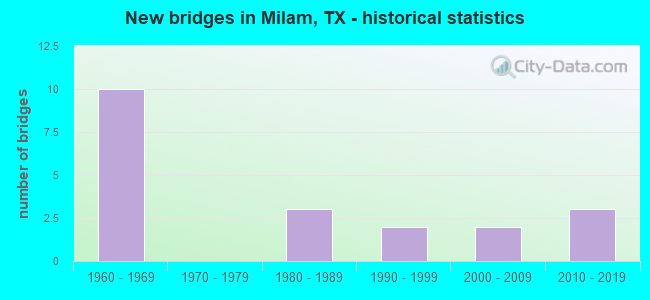
- New bridges - historical statistics
- 101960-1969
- 31980-1989
- 21990-1999
- 22000-2009
- 32010-2019

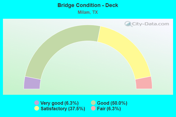
- Bridge Condition - Deck
- 6.3%Very good
- 50.0%Good
- 37.5%Satisfactory
- 6.3%Fair
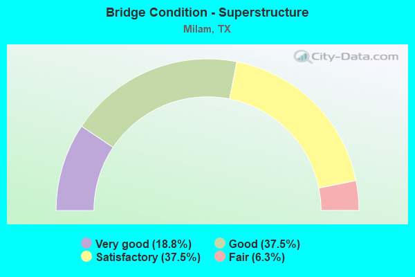
- Bridge Condition - Superstructure
- 18.8%Very good
- 37.5%Good
- 37.5%Satisfactory
- 6.3%Fair
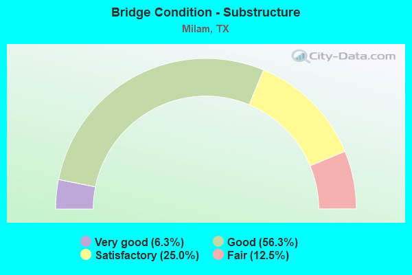
- Bridge Condition - Substructure
- 6.3%Very good
- 56.3%Good
- 25.0%Satisfactory
- 12.5%Fair
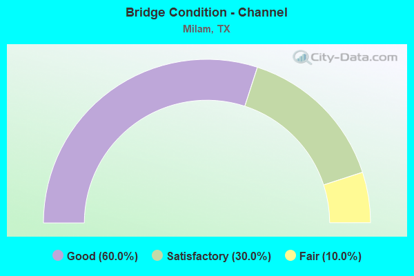
- Bridge Condition - Channel
- 60.0%Good
- 30.0%Satisfactory
- 10.0%Fair
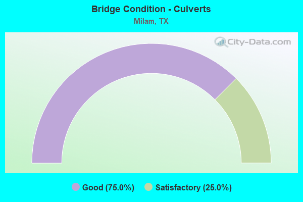
- Bridge Condition - Culverts
- 75.0%Good
- 25.0%Satisfactory
Find on map >> Show street view
Structure Number: 81307000019006, Location: 1.3 MI S OF SH87 (Lat: 31.441483, Lng: -93.768286), Route carried "on" structure: Federal lands road 192, Year Built: 2006, Status: Open, Structure Length: 1.28m (4.20ft), Average Daily Traffic: 50 (year 0000), Average Future Daily Traffic: 75 (year 2042), Design Load: HS 20, Features Intersected: WET LAND
Minimum Vertical Clearance: 30+ m (98+ ft), Kilometerpoint: 0.113, Lanes on structure: 1, Owner: U.S. Forest Service, Approaching Roadway Width: 6.7m (22.0ft), Material/Design: Prestressed concrete, Design/Construction: Frame, Number Of Spans In Main Unit: 1, Length of Maximum Span: 12.2m (40.0ft), Curb-To-Curb Width: 6.7m (22.0ft), Out-to-Out Width: 6.7m (22.0ft)
Condition: Deck: Very good, Superstructure: Very good, Substructure: Very good, Channel: Good, Deck Geometry: Somewhat better than minimum adequacy, Waterway Adequacy: Better than present minimum criteria, Approach Roadway Alignment: Equal to present desirable criteria, Designated Inspection Frequency: Every 24 months, Inspection Date: June 2020, Deck Structure Type: Concrete Precast Panels, Wearing Surface/Protective System: Wearing Surface: Bituminous
Find on map >> Show street view
Structure Number: 112020011903014, Location: 0.65 MI W OF SH 87 (Lat: 31.430611, Lng: -93.857331), Route carried "on" structure: State highway 21, Year Built: 1966, Status: Open, Structure Length: 4.63m (15.19ft), Average Daily Traffic: 1,854 (year 2019), Truck Traffic: 18%, Average Future Daily Traffic: 1,840 (year 2033), Design Load: H 20, Features Intersected: BOREGAS CREEK
Minimum Vertical Clearance: 30+ m (98+ ft), Kilometerpoint: 8.980, Lanes on structure: 2, Owner: State Highway Agency, Approaching Roadway Width: 7.9m (25.9ft), Material/Design: Concrete, Design/Construction: Stringer/Multi-beam, Number Of Spans In Main Unit: 5, Length of Maximum Span: 9.1m (29.9ft), Curb-To-Curb Width: 13.3m (43.6ft), Out-to-Out Width: 14.1m (46.3ft)
Condition: Deck: Good, Superstructure: Good, Substructure: Good, Channel: Good, Operating Rating: 60.8 metric tons, Method Used To Determine Operating Rating: Load Factor (LF), Inventory Rating: 36.3 metric tons, Method Used To Determine Inventory Rating: Load Factor (LF), Structural Evaluation: Better than present minimum criteria, Deck Geometry: Better than present minimum criteria, Waterway Adequacy: Equal to present minimum criteria, Approach Roadway Alignment: Equal to present desirable criteria, Designated Inspection Frequency: Every 24 months, Inspection Date: June 2020, Deck Structure Type: Concrete Cast-file-Place, Wearing Surface/Protective System: Wearing Surface: Bituminous
Find on map >> Show street view
Structure Number: 112020011904015, Location: 0.70 MI E OF SH 87 (Lat: 31.432908, Lng: -93.834469), Route carried "on" structure: State highway 21, Year Built: 1966, Status: Open, Structure Length: 0.67m (2.20ft), Average Daily Traffic: 3,330 (year 2019), Truck Traffic: 29%, Average Future Daily Traffic: 1,680 (year 2033), Design Load: HS 20, Features Intersected: WILSON BRANCH
Minimum Vertical Clearance: 30+ m (98+ ft), Kilometerpoint: 1.162, Lanes on structure: 4, Owner: State Highway Agency, Approaching Roadway Width: 14.3m (46.9ft), Material/Design: Concrete, Design/Construction: Culvert, Number Of Spans In Main Unit: 2, Length of Maximum Span: 3.0m (9.8ft)
Condition: Channel: Good, Culverts: Satisfactory, Operating Rating: 39.9 metric tons, Method Used To Determine Operating Rating: Load Factor (LF), Inventory Rating: 23.6 metric tons, Method Used To Determine Inventory Rating: Load Factor (LF), Structural Evaluation: Equal to present minimum criteria, Waterway Adequacy: Equal to present minimum criteria, Approach Roadway Alignment: Equal to present desirable criteria, Designated Inspection Frequency: Every 24 months, Inspection Date: June 2020
Find on map >> Show street view
Structure Number: 112020011904016, Location: 2.00 MI NE OF FM 3121 (Lat: 31.455858, Lng: -93.761567), Route carried "on" structure: State highway 21, Year Built: 1967, Status: Open, Structure Length: 6.10m (20.01ft), Average Daily Traffic: 2,650 (year 2013), Truck Traffic: 18%, Average Future Daily Traffic: 3,710 (year 2033), Design Load: H 20, Features Intersected: CARRICE CREEK
Minimum Vertical Clearance: 30+ m (98+ ft), Kilometerpoint: 9.339, Lanes on structure: 2, Owner: State Highway Agency, Approaching Roadway Width: 7.3m (24.0ft), Material/Design: Concrete, Design/Construction: Stringer/Multi-beam, Number Of Spans In Main Unit: 5, Length of Maximum Span: 12.2m (40.0ft), Curb-To-Curb Width: 13.4m (44.0ft), Out-to-Out Width: 14.1m (46.3ft)
Condition: Deck: Satisfactory, Superstructure: Satisfactory, Substructure: Fair, Channel: Good, Operating Rating: 57.1 metric tons, Method Used To Determine Operating Rating: Load Factor (LF), Inventory Rating: 34.5 metric tons, Method Used To Determine Inventory Rating: Load Factor (LF), Structural Evaluation: Somewhat better than minimum adequacy, Deck Geometry: Better than present minimum criteria, Waterway Adequacy: Equal to present minimum criteria, Approach Roadway Alignment: Equal to present desirable criteria, Designated Inspection Frequency: Every 24 months, Underwater Inspection Frequency: Every 60 months, Inspection Date: June 2020, Underwater Inspection Date: April 2018, Deck Structure Type: Concrete Cast-file-Place
Find on map >> Show street view
Structure Number: 112020011905017, Location: 0.0 MI W OF LOUISIANA S/L (Lat: 31.465361, Lng: -93.746928), Route carried "on" structure: State highway 21, Year Built: 1967, Status: Open, Structure Length: 402.21m (1319.59ft), Average Daily Traffic: 2,988 (year 2019), Truck Traffic: 17%, Average Future Daily Traffic: 3,220 (year 2035), Design Load: HS 20, Features Intersected: SABINE RIVER
Minimum Vertical Clearance: 30+ m (98+ ft), Kilometerpoint: 0.000, Lanes on structure: 2, Owner: State Highway Agency, Approaching Roadway Width: 12.8m (42.0ft), Material/Design: Steel continuous, Design/Construction: Stringer/Multi-beam, Number Of Spans In Main Unit: 3, Number Of Approach Spans: 181, Length of Maximum Span: 61.0m (200.1ft), Curb-To-Curb Width: 8.5m (27.9ft), Out-to-Out Width: 10.2m (33.5ft)
Condition: Deck: Satisfactory, Superstructure: Satisfactory, Substructure: Satisfactory, Channel: Satisfactory, Operating Rating: 52.6 metric tons, Method Used To Determine Operating Rating: Load Factor (LF), Inventory Rating: 31.7 metric tons, Method Used To Determine Inventory Rating: Load Factor (LF), Structural Evaluation: Equal to present minimum criteria, Deck Geometry: Meets minimum limits, Waterway Adequacy: Superior to present desirable criteria, Approach Roadway Alignment: Equal to present desirable criteria, Designated Inspection Frequency: Every 24 months, Underwater Inspection Frequency: Every 60 months, Inspection Date: June 2020, Underwater Inspection Date: August 2018, Deck Structure Type: Concrete Cast-file-Place
Find on map >> Show street view
Structure Number: 112020030402081, Location: 2.70 MI N OF FM 276 (Lat: 31.541283, Lng: -93.861911), Route carried "on" structure: State highway 87, Year Built: 1988, Status: Open, Structure Length: 2.44m (8.01ft), Average Daily Traffic: 569 (year 2020), Truck Traffic: 22%, Average Future Daily Traffic: 650 (year 2033), Design Load: HS 20, Features Intersected: BOURGHS CREEK
Minimum Vertical Clearance: 30+ m (98+ ft), Kilometerpoint: 9.727, Lanes on structure: 2, Owner: State Highway Agency, Approaching Roadway Width: 7.3m (24.0ft), Material/Design: Concrete, Design/Construction: Stringer/Multi-beam, Number Of Spans In Main Unit: 2, Length of Maximum Span: 12.2m (40.0ft), Curb-To-Curb Width: 10.2m (33.5ft), Out-to-Out Width: 11.1m (36.4ft)
Condition: Deck: Good, Superstructure: Good, Substructure: Good, Channel: Good, Operating Rating: 50.8 metric tons, Method Used To Determine Operating Rating: Load Factor (LF), Inventory Rating: 30.8 metric tons, Method Used To Determine Inventory Rating: Load Factor (LF), Structural Evaluation: Better than present minimum criteria, Deck Geometry: Equal to present minimum criteria, Waterway Adequacy: Equal to present minimum criteria, Approach Roadway Alignment: Equal to present desirable criteria, Designated Inspection Frequency: Every 24 months, Inspection Date: June 2020, Deck Structure Type: Concrete Cast-file-Place
Find on map >> Show street view
Structure Number: 112020030402082, Location: 1.75 MI N OF FM 276 (Lat: 31.528844, Lng: -93.856608), Route carried "on" structure: State highway 87, Year Built: 1988, Status: Open, Structure Length: 2.44m (8.01ft), Average Daily Traffic: 569 (year 2020), Truck Traffic: 22%, Average Future Daily Traffic: 650 (year 2033), Design Load: HS 20, Features Intersected: REEVES CREEK
Minimum Vertical Clearance: 30+ m (98+ ft), Kilometerpoint: 11.224, Lanes on structure: 2, Owner: State Highway Agency, Approaching Roadway Width: 10.2m (33.5ft), Material/Design: Concrete, Design/Construction: Stringer/Multi-beam, Number Of Spans In Main Unit: 2, Length of Maximum Span: 12.2m (40.0ft), Curb-To-Curb Width: 10.2m (33.5ft), Out-to-Out Width: 11.0m (36.1ft)
Condition: Deck: Good, Superstructure: Good, Substructure: Good, Channel: Satisfactory, Operating Rating: 50.8 metric tons, Method Used To Determine Operating Rating: Load Factor (LF), Inventory Rating: 30.8 metric tons, Method Used To Determine Inventory Rating: Load Factor (LF), Structural Evaluation: Better than present minimum criteria, Deck Geometry: Equal to present minimum criteria, Waterway Adequacy: Equal to present minimum criteria, Approach Roadway Alignment: Equal to present desirable criteria, Designated Inspection Frequency: Every 24 months, Inspection Date: June 2020, Deck Structure Type: Concrete Cast-file-Place
Find on map >> Show street view
Structure Number: 11202003040307, Location: 2.90 MI S OF SH 21 (Lat: 31.393958, Lng: -93.835672), Route carried "on" structure: State highway 87, Year Built: 1964, Status: Open, Structure Length: 7.41m (24.31ft), Average Daily Traffic: 3,051 (year 2020), Truck Traffic: 17%, Average Future Daily Traffic: 2,240 (year 2033), Design Load: H 20, Features Intersected: BOREGAS CREEK
Minimum Vertical Clearance: 30+ m (98+ ft), Kilometerpoint: 4.672, Lanes on structure: 2, Owner: State Highway Agency, Approaching Roadway Width: 7.3m (24.0ft), Material/Design: Concrete, Design/Construction: Stringer/Multi-beam, Number Of Spans In Main Unit: 8, Length of Maximum Span: 9.1m (29.9ft), Curb-To-Curb Width: 12.8m (42.0ft), Out-to-Out Width: 13.5m (44.3ft)
Condition: Deck: Satisfactory, Superstructure: Satisfactory, Substructure: Satisfactory, Channel: Good, Operating Rating: 59.0 metric tons, Method Used To Determine Operating Rating: Load Factor (LF), Inventory Rating: 35.4 metric tons, Method Used To Determine Inventory Rating: Load Factor (LF), Structural Evaluation: Equal to present minimum criteria, Deck Geometry: Equal to present minimum criteria, Waterway Adequacy: Equal to present minimum criteria, Approach Roadway Alignment: Equal to present desirable criteria, Designated Inspection Frequency: Every 24 months, Inspection Date: June 2020, Deck Structure Type: Concrete Cast-file-Place
Find on map >> Show street view
Structure Number: 112020030403071, Location: 3.45 MI S OF SH 21 (Lat: 31.385961, Lng: -93.835678), Route carried "on" structure: State highway 87, Year Built: 1964, Status: Open, Structure Length: 16.64m (54.59ft), Average Daily Traffic: 3,051 (year 2020), Truck Traffic: 17%, Average Future Daily Traffic: 2,240 (year 2033), Design Load: H 20, Features Intersected: PALO GAUCHO BAYOU
Minimum Vertical Clearance: 30+ m (98+ ft), Kilometerpoint: 5.533, Lanes on structure: 2, Owner: State Highway Agency, Approaching Roadway Width: 7.3m (24.0ft), Material/Design: Concrete, Design/Construction: Stringer/Multi-beam, Number Of Spans In Main Unit: 18, Length of Maximum Span: 9.1m (29.9ft), Curb-To-Curb Width: 9.0m (29.5ft), Out-to-Out Width: 10.1m (33.1ft)
Condition: Deck: Satisfactory, Superstructure: Satisfactory, Substructure: Fair, Channel: Fair, Operating Rating: 64.4 metric tons, Method Used To Determine Operating Rating: Load Factor (LF), Inventory Rating: 38.1 metric tons, Method Used To Determine Inventory Rating: Load Factor (LF), Structural Evaluation: Somewhat better than minimum adequacy, Deck Geometry: Meets minimum limits, Waterway Adequacy: Equal to present minimum criteria, Approach Roadway Alignment: Equal to present desirable criteria, Designated Inspection Frequency: Every 24 months, Inspection Date: June 2020, Deck Structure Type: Concrete Cast-file-Place
Find on map >> Show street view
Structure Number: 112020030403072, Location: 3.80 MI S OF SH 21 (Lat: 31.381581, Lng: -93.834922), Route carried "on" structure: State highway 87, Year Built: 1964, Status: Open, Structure Length: 0.67m (2.20ft), Average Daily Traffic: 3,051 (year 2020), Truck Traffic: 17%, Average Future Daily Traffic: 2,240 (year 2033), Design Load: HS 20, Features Intersected: CAUSEY CREEK
Minimum Vertical Clearance: 30+ m (98+ ft), Kilometerpoint: 6.146, Lanes on structure: 2, Owner: State Highway Agency, Approaching Roadway Width: 7.3m (24.0ft), Material/Design: Concrete, Design/Construction: Culvert, Number Of Spans In Main Unit: 2, Length of Maximum Span: 3.0m (9.8ft)
Condition: Channel: Good, Culverts: Good, Operating Rating: 39.9 metric tons, Method Used To Determine Operating Rating: Load Factor (LF), Inventory Rating: 23.6 metric tons, Method Used To Determine Inventory Rating: Load Factor (LF), Structural Evaluation: Equal to present minimum criteria, Waterway Adequacy: Equal to present minimum criteria, Approach Roadway Alignment: Equal to present desirable criteria, Designated Inspection Frequency: Every 24 months, Inspection Date: June 2020
Find on map >> Show street view
Structure Number: 112020167801003, Location: 7.05 MI E OF SH 87 (Lat: 31.372442, Lng: -93.726514), Route carried "on" structure: State highway 83, Year Built: 1969, Status: Open, Structure Length: 3.66m (12.01ft), Average Daily Traffic: 660 (year 2020), Truck Traffic: 9%, Average Future Daily Traffic: 970 (year 2033), Design Load: H 15, Features Intersected: COMA CREEK
Minimum Vertical Clearance: 30+ m (98+ ft), Kilometerpoint: 11.372, Lanes on structure: 2, Owner: State Highway Agency, Approaching Roadway Width: 7.9m (25.9ft), Material/Design: Concrete, Design/Construction: Stringer/Multi-beam, Number Of Spans In Main Unit: 3, Length of Maximum Span: 12.2m (40.0ft), Curb-To-Curb Width: 7.9m (25.9ft), Out-to-Out Width: 8.6m (28.2ft)
Condition: Deck: Satisfactory, Superstructure: Satisfactory, Substructure: Good, Channel: Good, Operating Rating: 60.8 metric tons, Method Used To Determine Operating Rating: Load Factor (LF), Inventory Rating: 36.3 metric tons, Method Used To Determine Inventory Rating: Load Factor (LF), Structural Evaluation: Equal to present minimum criteria, Deck Geometry: Somewhat better than minimum adequacy, Waterway Adequacy: Better than present minimum criteria, Approach Roadway Alignment: Equal to present desirable criteria, Designated Inspection Frequency: Every 24 months, Inspection Date: June 2020, Deck Structure Type: Concrete Cast-file-Place
Find on map >> Show street view
Structure Number: 112020167901002, Location: 3.00 MI E OF SH 87 (Lat: 31.522764, Lng: -93.799319), Route carried "on" structure: State highway 276, Year Built: 1967, Status: Open, Structure Length: 64.62m (212.01ft), Average Daily Traffic: 712 (year 2019), Truck Traffic: 9%, Average Future Daily Traffic: 1,090 (year 2033), Design Load: H 15, Features Intersected: PATROON BAYOU
Minimum Vertical Clearance: 30+ m (98+ ft), Kilometerpoint: 4.733, Lanes on structure: 2, Owner: State Highway Agency, Approaching Roadway Width: 7.9m (25.9ft), Material/Design: Concrete, Design/Construction: Stringer/Multi-beam, Number Of Spans In Main Unit: 53, Length of Maximum Span: 12.2m (40.0ft), Curb-To-Curb Width: 7.9m (25.9ft), Out-to-Out Width: 8.6m (28.2ft)
Condition: Deck: Fair, Superstructure: Fair, Substructure: Satisfactory, Channel: Satisfactory, Operating Rating: 39.0 metric tons, Method Used To Determine Operating Rating: Load Factor (LF), Inventory Rating: 23.6 metric tons, Method Used To Determine Inventory Rating: Load Factor (LF), Structural Evaluation: Somewhat better than minimum adequacy, Deck Geometry: Somewhat better than minimum adequacy, Waterway Adequacy: Equal to present minimum criteria, Approach Roadway Alignment: Equal to present desirable criteria, Designated Inspection Frequency: Every 24 months, Underwater Inspection Frequency: Every 60 months, Inspection Date: June 2020, Underwater Inspection Date: August 2019, Deck Structure Type: Concrete Cast-file-Place
Find on map >> Show street view
Structure Number: 112020317001001, Location: 1.60 MI S OF SH 21 (Lat: 31.414083, Lng: -93.781133), Route carried "on" structure: State highway 3121, Year Built: 1968, Status: Open, Structure Length: 43.89m (144.00ft), Average Daily Traffic: 2,382 (year 2019), Truck Traffic: 10%, Average Future Daily Traffic: 2,460 (year 2033), Design Load: H 20, Features Intersected: PALO GAUCHO BAYOU
Minimum Vertical Clearance: 30+ m (98+ ft), Kilometerpoint: 2.456, Lanes on structure: 2, Owner: State Highway Agency, Approaching Roadway Width: 10.3m (33.8ft), Material/Design: Concrete, Design/Construction: Stringer/Multi-beam, Number Of Spans In Main Unit: 36, Length of Maximum Span: 12.2m (40.0ft), Curb-To-Curb Width: 10.3m (33.8ft), Out-to-Out Width: 10.8m (35.4ft)
Condition: Deck: Satisfactory, Superstructure: Satisfactory, Substructure: Satisfactory, Channel: Satisfactory, Operating Rating: 53.5 metric tons, Method Used To Determine Operating Rating: Load Factor (LF), Inventory Rating: 32.7 metric tons, Method Used To Determine Inventory Rating: Load Factor (LF), Structural Evaluation: Equal to present minimum criteria, Deck Geometry: Meets minimum limits, Waterway Adequacy: Equal to present minimum criteria, Approach Roadway Alignment: Equal to present desirable criteria, Designated Inspection Frequency: Every 24 months, Underwater Inspection Frequency: Every 60 months, Inspection Date: June 2020, Underwater Inspection Date: May 2020, Deck Structure Type: Concrete Cast-file-Place
Find on map >> Show street view
Structure Number: 112020AA0101001, Location: 1.0 MI NE OF SH 87 (Lat: 31.538397, Lng: -93.844772), Route carried "on" structure: County highway , Year Built: 2009, Status: Open, Structure Length: 10.36m (33.99ft), Average Daily Traffic: 55 (year 2015), Average Future Daily Traffic: 65 (year 2035), Design Load: HL 93, Features Intersected: PATROON BAYOU, Facility Carried by Structure: REEVES RD
Minimum Vertical Clearance: 30+ m (98+ ft), Kilometerpoint: 1.448, Lanes on structure: 2, Owner: County Highway Agency, Approaching Roadway Width: 5.3m (17.4ft), Material/Design: Prestressed concrete, Design/Construction: Box Beam or Girders - Multiple, Number Of Spans In Main Unit: 4, Length of Maximum Span: 25.9m (85.0ft), Curb-To-Curb Width: 7.4m (24.3ft), Out-to-Out Width: 8.1m (26.6ft)
Condition: Deck: Good, Superstructure: Good, Substructure: Good, Channel: Good, Operating Rating: 54.4 metric tons, Method Used To Determine Operating Rating: Assigned ratings based on Load and Resistance Factor Design (LRFD) reported in metric tons, Inventory Rating: 32.7 metric tons, Method Used To Determine Inventory Rating: Assigned ratings based on Load and Resistance Factor Design (LRFD) reported in metric tons, Structural Evaluation: Better than present minimum criteria, Deck Geometry: Equal to present minimum criteria, Waterway Adequacy: Superior to present desirable criteria, Approach Roadway Alignment: Equal to present desirable criteria, Length Of Structure Improvement: 9.81m (32.19ft), Designated Inspection Frequency: Every 24 months, Underwater Inspection Frequency: Every 60 months, Inspection Date: July 2021, Underwater Inspection Date: Febuary 2021, Bridge Improvement Cost: $23,000, Roadway Improvement Cost: $6,000, Total Project Cost: $29,000, Deck Structure Type: Concrete Cast-file-Place, Wearing Surface/Protective System: Wearing Surface: Bituminous
Find on map >> Show street view
Structure Number: 112020AA0102001, Location: 0.4 MI NW OF FM 276 (Lat: 31.517817, Lng: -93.834958), Route carried "on" structure: County highway , Year Built: 2011, Status: Open, Structure Length: 1.52m (4.99ft), Average Daily Traffic: 100 (year 2018), Average Future Daily Traffic: 50 (year 2035), Design Load: HL 93, Features Intersected: DORSEY BRANCH, Facility Carried by Structure: CHAMBERS RD.
Minimum Vertical Clearance: 30+ m (98+ ft), Kilometerpoint: 0.644, Lanes on structure: 2, Owner: County Highway Agency, Approaching Roadway Width: 5.4m (17.7ft), Material/Design: Prestressed concrete, Design/Construction: Box Beam or Girders - Multiple, Number Of Spans In Main Unit: 1, Length of Maximum Span: 15.2m (49.9ft), Curb-To-Curb Width: 7.2m (23.6ft), Out-to-Out Width: 7.9m (25.9ft)
Condition: Deck: Good, Superstructure: Very good, Substructure: Good, Channel: Good, Operating Rating: 54.4 metric tons, Method Used To Determine Operating Rating: Assigned ratings based on Load and Resistance Factor Design (LRFD) reported in metric tons, Inventory Rating: 32.7 metric tons, Method Used To Determine Inventory Rating: Assigned ratings based on Load and Resistance Factor Design (LRFD) reported in metric tons, Structural Evaluation: Better than present minimum criteria, Deck Geometry: Somewhat better than minimum adequacy, Waterway Adequacy: Better than present minimum criteria, Approach Roadway Alignment: Equal to present desirable criteria, Designated Inspection Frequency: Every 24 months, Inspection Date: July 2021, Deck Structure Type: Concrete Cast-file-Place
Find on map >> Show street view
Structure Number: 112020AA0132001, Location: 3.55 MI E OF SH 87 (Lat: 31.479475, Lng: -93.795164), Route carried "on" structure: County highway , Year Built: 2012, Status: Open, Structure Length: 1.83m (6.00ft), Average Daily Traffic: 55 (year 2015), Average Future Daily Traffic: 40 (year 2035), Design Load: HL 93, Features Intersected: CORSEY CREEK, Facility Carried by Structure: CEDAR GROVE RD
Minimum Vertical Clearance: 30+ m (98+ ft), Kilometerpoint: 3.701, Lanes on structure: 2, Owner: County Highway Agency, Approaching Roadway Width: 6.1m (20.0ft), Material/Design: Prestressed concrete, Design/Construction: Box Beam or Girders - Multiple, Number Of Spans In Main Unit: 1, Length of Maximum Span: 18.3m (60.0ft), Curb-To-Curb Width: 7.3m (24.0ft), Out-to-Out Width: 8.0m (26.2ft)
Condition: Deck: Good, Superstructure: Very good, Substructure: Good, Channel: Good, Operating Rating: 54.4 metric tons, Method Used To Determine Operating Rating: Assigned ratings based on Load and Resistance Factor Design (LRFD) reported in metric tons, Inventory Rating: 32.7 metric tons, Method Used To Determine Inventory Rating: Assigned ratings based on Load and Resistance Factor Design (LRFD) reported in metric tons, Structural Evaluation: Better than present minimum criteria, Deck Geometry: Equal to present minimum criteria, Waterway Adequacy: Superior to present desirable criteria, Approach Roadway Alignment: Equal to present desirable criteria, Designated Inspection Frequency: Every 24 months, Inspection Date: July 2021, Deck Structure Type: Concrete Cast-file-Place
Find on map >> Show street view
Structure Number: 112020AA0211001, Location: 0.90 MI S OF FM 276 (Lat: 31.502764, Lng: -93.829458), Route carried "on" structure: County highway , Year Built: 1989, Status: Open, Structure Length: 0.88m (2.89ft), Average Daily Traffic: 110 (year 2018), Average Future Daily Traffic: 35 (year 2035), Design Load: HS 20, Features Intersected: MASON CREEK, Facility Carried by Structure: TELEPHONE RD
Minimum Vertical Clearance: 30+ m (98+ ft), Kilometerpoint: 1.448, Lanes on structure: 2, Owner: County Highway Agency, Approaching Roadway Width: 6.1m (20.0ft), Skew: 4 degrees, Material/Design: Concrete, Design/Construction: Culvert, Number Of Spans In Main Unit: 2, Length of Maximum Span: 2.7m (8.9ft), Curb-To-Curb Width: 7.2m (23.6ft), Out-to-Out Width: 14.4m (47.2ft)
Condition: Channel: Satisfactory, Culverts: Good, Operating Rating: 39.9 metric tons, Method Used To Determine Operating Rating: Load Factor (LF), Inventory Rating: 23.6 metric tons, Method Used To Determine Inventory Rating: Load Factor (LF), Structural Evaluation: Equal to present minimum criteria, Deck Geometry: Meets minimum limits, Waterway Adequacy: Better than present minimum criteria, Approach Roadway Alignment: Equal to present desirable criteria, Designated Inspection Frequency: Every 24 months, Inspection Date: July 2021, Deck Structure Type: Concrete Cast-file-Place, Wearing Surface/Protective System: Wearing Surface: Gravel
Find on map >> Show street view
Structure Number: 112020AA0221001, Location: 0.75 MI SW OF SH 87 (Lat: 31.419178, Lng: -93.848819), Route carried "on" structure: County highway , Year Built: 1999, Status: Open, Structure Length: 2.41m (7.91ft), Average Daily Traffic: 100 (year 2018), Average Future Daily Traffic: 35 (year 2035), Design Load: HS 20, Features Intersected: BOREGAS CREEK, Facility Carried by Structure: DORSEY RD
Minimum Vertical Clearance: 30+ m (98+ ft), Kilometerpoint: 1.127, Lanes on structure: 2, Owner: County Highway Agency, Approaching Roadway Width: 5.3m (17.4ft), Skew: 3 degrees, Material/Design: Prestressed concrete, Design/Construction: Stringer/Multi-beam, Number Of Spans In Main Unit: 1, Length of Maximum Span: 24.1m (79.1ft), Curb-To-Curb Width: 8.3m (27.2ft), Out-to-Out Width: 9.1m (29.9ft)
Condition: Deck: Good, Superstructure: Good, Substructure: Good, Channel: Satisfactory, Operating Rating: 54.4 metric tons, Method Used To Determine Operating Rating: Assigned rating based on Load Factor Design (LFD) reported in metric tons, Inventory Rating: 32.7 metric tons, Method Used To Determine Inventory Rating: Assigned rating based on Load Factor Design (LFD) reported in metric tons, Structural Evaluation: Better than present minimum criteria, Deck Geometry: Equal to present minimum criteria, Waterway Adequacy: Equal to present minimum criteria, Approach Roadway Alignment: Equal to present minimum criteria, Designated Inspection Frequency: Every 24 months, Inspection Date: July 2021, Deck Structure Type: Concrete Precast Panels
Find on map >> Show street view
Structure Number: 112020AA0221002, Location: 3.1 MI SW OF SH 87 (Lat: 31.393817, Lng: -93.870425), Route carried "on" structure: County highway , Year Built: 1999, Status: Open, Structure Length: 2.41m (7.91ft), Average Daily Traffic: 100 (year 2018), Average Future Daily Traffic: 90 (year 2035), Design Load: HS 20, Features Intersected: PALO GAUCHO BAYOU, Facility Carried by Structure: DORSEY RD
Minimum Vertical Clearance: 30+ m (98+ ft), Kilometerpoint: 4.989, Lanes on structure: 2, Owner: County Highway Agency, Approaching Roadway Width: 4.4m (14.4ft), Material/Design: Prestressed concrete, Design/Construction: Stringer/Multi-beam, Number Of Spans In Main Unit: 1, Length of Maximum Span: 24.1m (79.1ft), Curb-To-Curb Width: 8.3m (27.2ft), Out-to-Out Width: 9.1m (29.9ft)
Condition: Deck: Good, Superstructure: Good, Substructure: Good, Channel: Fair, Operating Rating: 54.4 metric tons, Method Used To Determine Operating Rating: Assigned rating based on Load Factor Design (LFD) reported in metric tons, Inventory Rating: 32.7 metric tons, Method Used To Determine Inventory Rating: Assigned rating based on Load Factor Design (LFD) reported in metric tons, Structural Evaluation: Better than present minimum criteria, Deck Geometry: Equal to present minimum criteria, Waterway Adequacy: Equal to present minimum criteria, Approach Roadway Alignment: Somewhat better than minimum adequacy, Designated Inspection Frequency: Every 24 months, Inspection Date: July 2021, Deck Structure Type: Concrete Precast Panels
Find on map >> Show street view
Structure Number: 112020AA0239001, Location: 0.5 Mi E of SH 87 (Lat: 31.409211, Lng: -93.825964), Route carried "on" structure: County highway , Year Built: 2018, Status: Open, Structure Length: 0.98m (3.22ft), Average Daily Traffic: 50 (year 2017), Average Future Daily Traffic: 50 (year 2037), Design Load: HL 93, Features Intersected: Wilson Branch, Facility Carried by Structure: Davidson Road
Minimum Vertical Clearance: 30+ m (98+ ft), Kilometerpoint: 0.805, Lanes on structure: 2, Owner: County Highway Agency, Approaching Roadway Width: 5.5m (18.0ft), Material/Design: Concrete, Design/Construction: Culvert, Number Of Spans In Main Unit: 3, Length of Maximum Span: 3.0m (9.8ft), Curb-To-Curb Width: 6.8m (22.3ft), Out-to-Out Width: 7.3m (24.0ft)
Condition: Channel: Good, Culverts: Good, Operating Rating: 54.4 metric tons, Method Used To Determine Operating Rating: Assigned ratings based on Load and Resistance Factor Design (LRFD) reported in metric tons, Inventory Rating: 32.7 metric tons, Method Used To Determine Inventory Rating: Assigned ratings based on Load and Resistance Factor Design (LRFD) reported in metric tons, Structural Evaluation: Better than present minimum criteria, Deck Geometry: Somewhat better than minimum adequacy, Waterway Adequacy: Equal to present minimum criteria, Approach Roadway Alignment: Equal to present minimum criteria, Designated Inspection Frequency: Every 24 months, Inspection Date: July 2021, Deck Structure Type: Concrete Cast-file-Place, Wearing Surface/Protective System: Wearing Surface: Monolithic Concrete