Bridge Statistics for Mifflinville, Pennsylvania (PA)
Condition, Traffic, Stress, Structural Evaluation, Project Costs
- National Bridge Inventory (NBI) Statistics
- 13Number of bridges
- 210ft / 63.8mTotal length
- $2,913,000Total costs
- 65,717Total average daily traffic
- 20,957Total average daily truck traffic
- National Bridge Inventory (NBI) Registered Bridges for Mifflinville
- No street view available for this location
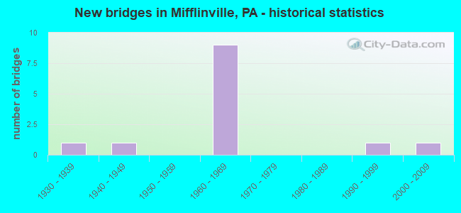
- New bridges - historical statistics
- 11930-1939
- 11940-1949
- 91960-1969
- 11990-1999
- 12000-2009

- Reconstructed bridges - Historical Statistics
- 11970-1979
- 01980-1989
- 01990-1999
- 22000-2009


- Bridge Condition - Deck
- 50.0%Very good
- 16.7%Good
- 33.3%Satisfactory

- Bridge Condition - Superstructure
- 33.3%Very good
- 33.3%Good
- 33.3%Fair

- Bridge Condition - Substructure
- 83.3%Good
- 16.7%Poor

- Bridge Condition - Channel
- 25.0%Very good
- 25.0%Good
- 25.0%Satisfactory
- 25.0%Poor
Find on map >> Show street view
Structure Number: 12518, Location: MIFFLINVILLE (Lat: 41.024239, Lng: -76.318644), Route carried "on" structure: Interstate 80, Year Built: 1964, Status: Open, Structure Length: 3.51m (11.52ft), Average Daily Traffic: 15,527 (year 2021), Truck Traffic: 41%, Average Future Daily Traffic: 23,804 (year 2032), Design Load: HL 93, Features Intersected: OVER S.R. 0339
Minimum Vertical Clearance: 30+ m (98+ ft), Kilometerpoint: 21.678, Lanes on structure: 2, Lanes under structure: 2, Base Highway Network: Yes, Owner: State Highway Agency, Approaching Roadway Width: 12.8m (42.0ft), Skew: 12 degrees, Material/Design: Prestressed concrete, Design/Construction: Box Beam or Girders - Single/Spread, Number Of Spans In Main Unit: 3, Length of Maximum Span: 14.3m (46.9ft), Curb-To-Curb Width: 12.8m (42.0ft), Out-to-Out Width: 13.9m (45.6ft)
Condition: Deck: Very good, Superstructure: Very good, Substructure: Good, Operating Rating: 57.2 metric tons, Method Used To Determine Operating Rating: Load and Resistance Factor (LRFR), Inventory Rating: 31.8 metric tons, Method Used To Determine Inventory Rating: Load and Resistance Factor (LRFR), Structural Evaluation: Better than present minimum criteria, Deck Geometry: Equal to present desirable criteria, Underclear: Better than present minimum criteria, Approach Roadway Alignment: Equal to present desirable criteria, Length Of Structure Improvement: 3.50m (11.48ft), Designated Inspection Frequency: Every 24 months, Inspection Date: Febuary 2021, Bridge Improvement Cost: $11,000, Roadway Improvement Cost: $50,000, Total Project Cost: $143,000, Deck Structure Type: Concrete Cast-file-Place, Wearing Surface/Protective System: Wearing Surface: Epoxy Overlay, Deck Protection: Epoxy Coated Reinforcing
Find on map >> Show street view
Structure Number: 1252, Location: S. OF MIFFLINVILLE (Lat: 41.024592, Lng: -76.318522), Route carried "on" structure: Interstate 80, Year Built: 1964, Year Reconstructed: 2012, Status: Open, Structure Length: 3.51m (11.52ft), Average Daily Traffic: 15,535 (year 2021), Truck Traffic: 42%, Average Future Daily Traffic: 23,552 (year 2032), Design Load: HL 93, Features Intersected: OVER S.R. 0339
Minimum Vertical Clearance: 30+ m (98+ ft), Kilometerpoint: 21.700, Lanes on structure: 2, Lanes under structure: 2, Base Highway Network: Yes, Owner: State Highway Agency, Approaching Roadway Width: 12.8m (42.0ft), Skew: 12 degrees, Material/Design: Prestressed concrete, Design/Construction: Box Beam or Girders - Single/Spread, Number Of Spans In Main Unit: 3, Length of Maximum Span: 14.3m (46.9ft), Curb-To-Curb Width: 15.2m (49.9ft), Out-to-Out Width: 16.3m (53.5ft)
Condition: Deck: Very good, Superstructure: Very good, Substructure: Good, Operating Rating: 58.3 metric tons, Method Used To Determine Operating Rating: Assigned ratings based on Load and Resistance Factor Design (LRFD) reported by rating factor (RF) using HL93 loadings, Inventory Rating: 36.6 metric tons, Method Used To Determine Inventory Rating: Assigned ratings based on Load and Resistance Factor Design (LRFD) reported by rating factor (RF) using HL93 loadings, Structural Evaluation: Better than present minimum criteria, Deck Geometry: Superior to present desirable criteria, Underclear: Equal to present minimum criteria, Approach Roadway Alignment: Equal to present desirable criteria, Length Of Structure Improvement: 3.50m (11.48ft), Designated Inspection Frequency: Every 48 months, Inspection Date: Febuary 2019, Bridge Improvement Cost: $21,000, Roadway Improvement Cost: $61,000, Total Project Cost: $281,000, Deck Structure Type: Concrete Cast-file-Place, Wearing Surface/Protective System: Wearing Surface: Epoxy Overlay, Deck Protection: Epoxy Coated Reinforcing
Find on map >> Show street view
Structure Number: 12521, Location: 1.5 MI S OF MIFFLINVILLE (Lat: 41.014781, Lng: -76.303144), Route carried "on" structure: Interstate 80, Year Built: 1964, Year Reconstructed: 2007, Status: Open, Structure Length: 3.66m (12.01ft), Average Daily Traffic: 15,527 (year 2021), Truck Traffic: 41%, Average Future Daily Traffic: 23,804 (year 2032), Design Load: H 20, Features Intersected: OVER SR 2028
Minimum Vertical Clearance: 30+ m (98+ ft), Kilometerpoint: 23.155, Lanes on structure: 2, Lanes under structure: 2, Base Highway Network: Yes, Owner: State Highway Agency, Approaching Roadway Width: 12.8m (42.0ft), Skew: 12 degrees, Material/Design: Steel continuous, Design/Construction: Stringer/Multi-beam, Number Of Spans In Main Unit: 2, Length of Maximum Span: 21.0m (68.9ft), Curb-To-Curb Width: 12.2m (40.0ft), Out-to-Out Width: 13.2m (43.3ft)
Condition: Deck: Very good, Superstructure: Good, Substructure: Good, Operating Rating: 70.8 metric tons, Method Used To Determine Operating Rating: Load Factor (LF), Inventory Rating: 41.7 metric tons, Method Used To Determine Inventory Rating: Load Factor (LF), Structural Evaluation: Better than present minimum criteria, Deck Geometry: Better than present minimum criteria, Underclear: Equal to present minimum criteria, Approach Roadway Alignment: Equal to present desirable criteria, Length Of Structure Improvement: 3.70m (12.14ft), Designated Inspection Frequency: Every 48 months, Inspection Date: Febuary 2019, Deck Structure Type: Concrete Cast-file-Place, Wearing Surface/Protective System: Wearing Surface: Epoxy Overlay, Deck Protection: Epoxy Coated Reinforcing
Find on map >> Show street view
Structure Number: 12688, Location: VILLAGE OF MIFFLINVILLE (Lat: 41.035761, Lng: -76.311200), Route carried "on" structure: State highway , Year Built: 1994, Status: Open, Structure Length: 50.05m (164.21ft), Average Daily Traffic: 6,303 (year 2022), Truck Traffic: 10%, Average Future Daily Traffic: 8,982 (year 2032), Design Load: HS 25 or greater, Features Intersected: D&H RR,NB SUSQUEHANNA R., Facility Carried by Structure: SR 2028
Minimum Vertical Clearance: 30+ m (98+ ft), Kilometerpoint: 0.132, Lanes on structure: 2, Owner: State Highway Agency, Approaching Roadway Width: 12.2m (40.0ft), Material/Design: Prestressed concrete continuous, Design/Construction: Stringer/Multi-beam, Number Of Spans In Main Unit: 11, Number Of Approach Spans: 1, Length of Maximum Span: 42.7m (140.1ft), Curb or Sidewalk Widths: Left: 0.2m (0.7ft), Right: 1.8m (5.9ft), Curb-To-Curb Width: 12.2m (40.0ft), Out-to-Out Width: 15.1m (49.5ft)
Condition: Deck: Good, Superstructure: Good, Substructure: Good, Channel: Good, Operating Rating: 50.8 metric tons, Method Used To Determine Operating Rating: Load Factor (LF), Inventory Rating: 29.9 metric tons, Method Used To Determine Inventory Rating: Load Factor (LF), Structural Evaluation: Better than present minimum criteria, Deck Geometry: Somewhat better than minimum adequacy, Underclear: High priority of corrective action, Waterway Adequacy: Superior to present desirable criteria, Approach Roadway Alignment: Equal to present desirable criteria, Length Of Structure Improvement: 50.80m (166.67ft), Designated Inspection Frequency: Every 24 months, Underwater Inspection Frequency: Every 24 months, Inspection Date: April 2020, Underwater Inspection Date: July 2021, Bridge Improvement Cost: $169,000, Roadway Improvement Cost: $497,000, Total Project Cost: $2,279,000, Deck Structure Type: Concrete Cast-file-Place, Wearing Surface/Protective System: Wearing Surface: Monolithic Concrete, Deck Protection: Epoxy Coated Reinforcing
Find on map >> Show street view
Structure Number: 12825, Location: 2.1 M.SSW OF MIFFLINVILLE (Lat: 41.001575, Lng: -76.319192), Route carried "on" structure: City street , Year Built: 1940, Year Reconstructed: 1982, Status: Posted for load, Structure Length: 1.31m (4.30ft), Average Daily Traffic: 120 (year 2021), Truck Traffic: 5%, Average Future Daily Traffic: 186 (year 2043), Design Load: HS 20, Features Intersected: TEN MILE RUN, Facility Carried by Structure: T-409 MIFFLIN BR#1
Minimum Vertical Clearance: 30+ m (98+ ft), Kilometerpoint: 0.000, Lanes on structure: 2, Owner: Town or Township Highway Agency, Approaching Roadway Width: 6.1m (20.0ft), Skew: 2 degrees, Material/Design: Steel, Design/Construction: Stringer/Multi-beam, Number Of Spans In Main Unit: 1, Length of Maximum Span: 12.5m (41.0ft), Curb or Sidewalk Widths: Left: 0.1m (0.3ft), Right: 0.1m (0.3ft), Curb-To-Curb Width: 7.3m (24.0ft), Out-to-Out Width: 7.6m (24.9ft)
Condition: Deck: Satisfactory, Superstructure: Fair, Substructure: Good, Channel: Satisfactory, Operating Rating: 34.5 metric tons, Method Used To Determine Operating Rating: Load Factor (LF), Inventory Rating: 20.9 metric tons, Method Used To Determine Inventory Rating: Load Factor (LF), Structural Evaluation: Somewhat better than minimum adequacy, Deck Geometry: Somewhat better than minimum adequacy, Waterway Adequacy: Better than present minimum criteria, Approach Roadway Alignment: Equal to present desirable criteria, Bridge Posting: Required (Relationship of Operating Rating to Maximum Legal Load: 10.0 - 19.9% below), Length Of Structure Improvement: 1.30m (4.27ft), Designated Inspection Frequency: Every 24 months, Other Special Inspection Frequency: Every 12 months, Inspection Date: April 2021, Other Special Inspection Date: April 2021, Bridge Improvement Cost: $8,000, Roadway Improvement Cost: $50,000, Total Project Cost: $102,000, Deck Structure Type: Open Grating
Find on map >> Show street view
Structure Number: 12826, Location: 2.4 MI S. OF MIFFLINVILLE (Lat: 40.998203, Lng: -76.311556), Route carried "on" structure: City street , Year Built: 1936, Status: Open, Structure Length: 0.85m (2.79ft), Average Daily Traffic: 100 (year 2021), Truck Traffic: 2%, Average Future Daily Traffic: 155 (year 2043), Features Intersected: TEN MILE RUN, Facility Carried by Structure: T-409 MIFFLIN BR#2
Minimum Vertical Clearance: 30+ m (98+ ft), Kilometerpoint: 0.000, Lanes on structure: 1, Owner: Town or Township Highway Agency, Approaching Roadway Width: 5.2m (17.1ft), Skew: 3 degrees, Material/Design: Steel, Design/Construction: Stringer/Multi-beam, Number Of Spans In Main Unit: 1, Length of Maximum Span: 7.9m (25.9ft), Curb or Sidewalk Widths: Left: 0.1m (0.3ft), Right: 0.1m (0.3ft), Curb-To-Curb Width: 5.2m (17.1ft), Out-to-Out Width: 6.2m (20.3ft)
Condition: Deck: Satisfactory, Superstructure: Fair, Substructure: Poor, Channel: Poor, Operating Rating: 60.8 metric tons, Method Used To Determine Operating Rating: Field evaluation and documented engineering judgment, Inventory Rating: 32.7 metric tons, Method Used To Determine Inventory Rating: Field evaluation and documented engineering judgment, Structural Evaluation: Meets minimum limits, Deck Geometry: High priority of corrective action, Waterway Adequacy: Better than present minimum criteria, Approach Roadway Alignment: Somewhat better than minimum adequacy, Length Of Structure Improvement: 0.90m (2.95ft), Designated Inspection Frequency: Every 24 months, Inspection Date: April 2021, Bridge Improvement Cost: $8,000, Roadway Improvement Cost: $50,000, Total Project Cost: $108,000, Deck Structure Type: Concrete Cast-file-Place, Wearing Surface/Protective System: Wearing Surface: Bituminous
Find on map >> Show street view
Structure Number: 45515, Location: 1 mi West of Mifflinville (Lat: 41.022231, Lng: -76.319619), Route carried "on" structure: State highway , Year Built: 2009, Status: Open, Structure Length: 0.91m (2.99ft), Average Daily Traffic: 323 (year 2022), Truck Traffic: 8%, Average Future Daily Traffic: 374 (year 2032), Design Load: HS 25 or greater, Features Intersected: over Ten Mile Run, Facility Carried by Structure: SR 2020
Minimum Vertical Clearance: 30+ m (98+ ft), Kilometerpoint: 5.184, Lanes on structure: 2, Owner: State Highway Agency, Approaching Roadway Width: 6.1m (20.0ft), Skew: 2 degrees, Material/Design: Concrete, Design/Construction: Culvert, Number Of Spans In Main Unit: 1, Length of Maximum Span: 8.5m (27.9ft)
Condition: Channel: Very good, Culverts: Good, Operating Rating: 98.9 metric tons, Method Used To Determine Operating Rating: Load Factor (LF), Inventory Rating: 68.0 metric tons, Method Used To Determine Inventory Rating: Load Factor (LF), Structural Evaluation: Better than present minimum criteria, Waterway Adequacy: Superior to present desirable criteria, Approach Roadway Alignment: Equal to present desirable criteria, Designated Inspection Frequency: Every 48 months, Inspection Date: Febuary 2019
Find on map >> Show street view
Structure Number: 12518, Location: MIFFLINVILLE (Lat: 41.024239, Lng: -76.318644), Route carried "under" structure: State highway 339, Year Built: 1964, Structure Length: 0. m, Average Daily Traffic: 4,257 (year 2022), Truck Traffic: 10%, Features Intersected: OVER S.R. 0339, Facility Carried by Structure: SR 0080
Minimum Vertical Clearance: 4.88m (16.01ft), Kilometerpoint: 23.822, Lanes on structure: 2, Lanes under structure: 2, Material/Design: Prestressed concrete, Design/Construction: Box Beam or Girders - Single/Spread, Length of Maximum Span: 14.3m (46.9ft)
Find on map >> Show street view
Structure Number: 1252, Location: S. OF MIFFLINVILLE (Lat: 41.024592, Lng: -76.318522), Route carried "under" structure: State highway 339, Year Built: 1964, Structure Length: 0. m, Average Daily Traffic: 4,257 (year 2022), Truck Traffic: 10%, Features Intersected: OVER S.R. 0339, Facility Carried by Structure: SR 80 WBL
Minimum Vertical Clearance: 4.65m (15.26ft), Kilometerpoint: 23.822, Lanes on structure: 2, Lanes under structure: 2, Material/Design: Prestressed concrete, Design/Construction: Box Beam or Girders - Single/Spread, Length of Maximum Span: 14.3m (46.9ft)
Find on map >> Show street view
Structure Number: 12521, Location: 1.5 MI S OF MIFFLINVILLE (Lat: 41.014781, Lng: -76.303144), Route carried "under" structure: State highway , Year Built: 1964, Structure Length: 0. m, Average Daily Traffic: 942 (year 2022), Truck Traffic: 5%, Features Intersected: OVER SR 2028, Facility Carried by Structure: SR 0080 EBL
Minimum Vertical Clearance: 4.71m (15.45ft), Kilometerpoint: 3.075, Lanes on structure: 2, Lanes under structure: 2, Material/Design: Steel continuous, Design/Construction: Stringer/Multi-beam, Length of Maximum Span: 21.0m (68.9ft)
Find on map >> Show street view
Structure Number: 12522, Location: 1.5 MI E OF MIFFLINVILLE (Lat: 41.015169, Lng: -76.303003), Route carried "under" structure: State highway , Year Built: 1964, Structure Length: 0. m, Average Daily Traffic: 942 (year 2022), Truck Traffic: 5%, Features Intersected: OVER S.R. 2028, Facility Carried by Structure: SR 0080 WBL
Minimum Vertical Clearance: 4.41m (14.47ft), Kilometerpoint: 3.075, Lanes on structure: 2, Lanes under structure: 2, Material/Design: Steel continuous, Design/Construction: Stringer/Multi-beam, Length of Maximum Span: 21.0m (68.9ft)
Find on map >> Show street view
Structure Number: 12523, Location: 2 MI E OF MIFFLINVILLE (Lat: 41.012078, Lng: -76.274497), Route carried "under" structure: State highway , Year Built: 1964, Structure Length: 0. m, Average Daily Traffic: 942 (year 2022), Truck Traffic: 5%, Features Intersected: OVER S.R. 2028, Facility Carried by Structure: SR 0080
Minimum Vertical Clearance: 4.60m (15.09ft), Kilometerpoint: 5.255, Lanes on structure: 2, Lanes under structure: 2, Material/Design: Steel continuous, Design/Construction: Stringer/Multi-beam, Length of Maximum Span: 12.8m (42.0ft)
Find on map >> Show street view
Structure Number: 12524, Location: 2 MI E OF MIFFLINVILLE (Lat: 41.012372, Lng: -76.273964), Route carried "under" structure: State highway , Year Built: 1964, Structure Length: 0. m, Average Daily Traffic: 942 (year 2022), Truck Traffic: 5%, Features Intersected: OVER S.R. 2028, Facility Carried by Structure: SR 0080
Minimum Vertical Clearance: 4.55m (14.93ft), Kilometerpoint: 5.255, Lanes on structure: 2, Lanes under structure: 2, Material/Design: Steel continuous, Design/Construction: Stringer/Multi-beam, Length of Maximum Span: 12.8m (42.0ft)