Bridge Statistics for Midway, Kentucky (KY)
Condition, Traffic, Stress, Structural Evaluation, Project Costs
- National Bridge Inventory (NBI) Statistics
- 25Number of bridges
- 262ft / 80.1mTotal length
- $4,032,000Total costs
- 277,146Total average daily traffic
- 34,188Total average daily truck traffic
- National Bridge Inventory (NBI) Registered Bridges for Midway
- No street view available for this location
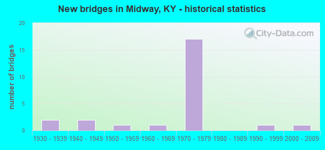
- New bridges - historical statistics
- 21930-1939
- 21940-1949
- 11950-1959
- 11960-1969
- 171970-1979
- 11990-1999
- 12000-2009


- Bridge Condition - Deck
- 57.1%Good
- 35.7%Satisfactory
- 7.1%Fair

- Bridge Condition - Superstructure
- 7.1%Very good
- 21.4%Good
- 50.0%Satisfactory
- 14.3%Fair
- 7.1%Poor

- Bridge Condition - Substructure
- 64.3%Good
- 21.4%Satisfactory
- 14.3%Fair

- Bridge Condition - Channel
- 8.3%Very good
- 33.3%Good
- 50.0%Satisfactory
- 8.3%Fair

- Bridge Condition - Culverts
- 50.0%Good
- 50.0%Satisfactory
Find on map >> Show street view
Structure Number: 105B00020N, Location: 2.1 MI East of KY 341 (Lat: 38.141389, Lng: -84.645000), Route carried "on" structure: US 62, Year Built: 1938, Year Reconstructed: 1988, Status: Open, Structure Length: 6.58m (21.59ft), Average Daily Traffic: 9,289 (year 2019), Truck Traffic: 11%, Average Future Daily Traffic: 7,709 (year 2039), Design Load: HS 20, Features Intersected: S.FK ELKHORN CREEK
Minimum Vertical Clearance: 30+ m (98+ ft), Kilometerpoint: 0.013, Lanes on structure: 2, Base Highway Network: Yes, Owner: State Highway Agency, Approaching Roadway Width: 7.6m (24.9ft), Material/Design: Concrete, Design/Construction: Tee Beam, Number Of Spans In Main Unit: 5, Length of Maximum Span: 12.2m (40.0ft), Curb-To-Curb Width: 7.9m (25.9ft), Out-to-Out Width: 8.8m (28.9ft)
Condition: Deck: Satisfactory, Superstructure: Fair, Substructure: Fair, Channel: Satisfactory, Operating Rating: 61.1 metric tons, Method Used To Determine Operating Rating: Load Factor (LF), Inventory Rating: 36.7 metric tons, Method Used To Determine Inventory Rating: Load Factor (LF), Structural Evaluation: Somewhat better than minimum adequacy, Deck Geometry: High priority of corrective action, Waterway Adequacy: Equal to present desirable criteria, Approach Roadway Alignment: Better than present minimum criteria, Length Of Structure Improvement: 0.66m (2.17ft), Designated Inspection Frequency: Every 24 months, Inspection Date: March 2021, Bridge Improvement Cost: $771,000, Total Project Cost: $771,000, Deck Structure Type: Concrete Cast-file-Place, Wearing Surface/Protective System: Wearing Surface: Latex Concrete
Find on map >> Show street view
Structure Number: 105B00082N, Location: 1.4 MI S OF JCT KY 1973 (Lat: 38.162222, Lng: -84.636944), Route carried "on" structure: County highway 1206, Year Built: 1973, Status: Open, Structure Length: 10.77m (35.33ft), Average Daily Traffic: 176 (year 2012), Average Future Daily Traffic: 153 (year 2032), Design Load: H 20, Features Intersected: I 64, Facility Carried by Structure: CANE RUN RD
Minimum Vertical Clearance: 30+ m (98+ ft), Kilometerpoint: 6.186, Lanes on structure: 2, Lanes under structure: 4, Owner: State Highway Agency, Approaching Roadway Width: 8.5m (27.9ft), Skew: 3 degrees, Material/Design: Steel continuous, Design/Construction: Stringer/Multi-beam, Number Of Spans In Main Unit: 4, Length of Maximum Span: 32.5m (106.6ft), Curb or Sidewalk Widths: Left: 0.2m (0.7ft), Right: 0.2m (0.7ft), Curb-To-Curb Width: 8.5m (27.9ft), Out-to-Out Width: 9.6m (31.5ft)
Condition: Deck: Good, Superstructure: Satisfactory, Substructure: Satisfactory, Operating Rating: 53.2 metric tons, Method Used To Determine Operating Rating: Load Factor (LF), Inventory Rating: 31.9 metric tons, Method Used To Determine Inventory Rating: Load Factor (LF), Structural Evaluation: Equal to present minimum criteria, Deck Geometry: Equal to present minimum criteria, Underclear: Equal to present minimum criteria, Approach Roadway Alignment: Better than present minimum criteria, Designated Inspection Frequency: Every 24 months, Inspection Date: March 2021, Deck Structure Type: Concrete Cast-file-Place, Wearing Surface/Protective System: Wearing Surface: Monolithic Concrete
Find on map >> Show street view
Structure Number: 105C00110N, Location: E OF WOODFORD CO. LINE (Lat: 38.173611, Lng: -84.706389), Route carried "on" structure: County highway 1215, Year Built: 2001, Status: Open, Structure Length: 2.83m (9.28ft), Average Daily Traffic: 110 (year 2006), Average Future Daily Traffic: 2,026 (year 2026), Design Load: HS 25 or greater, Features Intersected: SOUTH ELKHORN CREEK, Facility Carried by Structure: FISHERS MILL RD
Minimum Vertical Clearance: 30+ m (98+ ft), Kilometerpoint: 4.690, Lanes on structure: 2, Owner: County Highway Agency, Approaching Roadway Width: 6.9m (22.6ft), Material/Design: Prestressed concrete, Design/Construction: Box Beam or Girders - Multiple, Number Of Spans In Main Unit: 1, Length of Maximum Span: 27.4m (89.9ft), Curb-To-Curb Width: 6.9m (22.6ft), Out-to-Out Width: 7.4m (24.3ft)
Condition: Deck: Satisfactory, Superstructure: Good, Substructure: Satisfactory, Channel: Satisfactory, Operating Rating: 99.8 metric tons, Method Used To Determine Operating Rating: Load Factor (LF), Inventory Rating: 63.1 metric tons, Method Used To Determine Inventory Rating: Load Factor (LF), Structural Evaluation: Equal to present minimum criteria, Deck Geometry: Meets minimum limits, Waterway Adequacy: Better than present minimum criteria, Approach Roadway Alignment: Somewhat better than minimum adequacy, Designated Inspection Frequency: Every 24 months, Inspection Date: Febuary 2021, Deck Structure Type: Concrete Precast Panels, Wearing Surface/Protective System: Wearing Surface: Monolithic Concrete
Find on map >> Show street view
Structure Number: 120B00001N, Location: .15 MI N OF US 62 (Lat: 38.161944, Lng: -84.686667), Route carried "on" structure: US 421, Year Built: 1948, Status: Open, Structure Length: 0.76m (2.49ft), Average Daily Traffic: 6,527 (year 2019), Truck Traffic: 9%, Average Future Daily Traffic: 5,417 (year 2039), Design Load: H 20, Features Intersected: LEE BRANCH
Minimum Vertical Clearance: 30+ m (98+ ft), Kilometerpoint: 0.520, Lanes on structure: 2, Base Highway Network: Yes, Owner: State Highway Agency, Approaching Roadway Width: 7.8m (25.6ft), Material/Design: Concrete, Design/Construction: Culvert, Number Of Spans In Main Unit: 2, Length of Maximum Span: 3.7m (12.1ft)
Condition: Channel: Good, Culverts: Good, Operating Rating: 68.6 metric tons, Method Used To Determine Operating Rating: Load Factor (LF), Inventory Rating: 41.2 metric tons, Method Used To Determine Inventory Rating: Load Factor (LF), Structural Evaluation: Better than present minimum criteria, Waterway Adequacy: Better than present minimum criteria, Approach Roadway Alignment: Equal to present desirable criteria, Designated Inspection Frequency: Every 24 months, Inspection Date: November 2020
Find on map >> Show street view
Structure Number: 120B00003N, Location: .1 MI N OF JCT US 62-421 (Lat: 38.160000, Lng: -84.677778), Route carried "on" structure: State highway 341, Year Built: 1973, Status: Posted for load, Structure Length: 8.50m (27.89ft), Average Daily Traffic: 2,383 (year 2019), Truck Traffic: 10%, Average Future Daily Traffic: 2,097 (year 2039), Design Load: HS 20, Features Intersected: I 64
Minimum Vertical Clearance: 30+ m (98+ ft), Kilometerpoint: 0.220, Lanes on structure: 2, Lanes under structure: 4, Owner: State Highway Agency, Approaching Roadway Width: 19.6m (64.3ft), Material/Design: Concrete continuous, Design/Construction: Tee Beam, Number Of Spans In Main Unit: 4, Length of Maximum Span: 26.7m (87.6ft), Curb or Sidewalk Widths: Left: 0.2m (0.7ft), Right: 0.2m (0.7ft), Curb-To-Curb Width: 19.6m (64.3ft), Out-to-Out Width: 20.5m (67.3ft)
Condition: Deck: Satisfactory, Superstructure: Satisfactory, Substructure: Good, Operating Rating: 33.1 metric tons, Method Used To Determine Operating Rating: Load Factor (LF), Inventory Rating: 19.9 metric tons, Method Used To Determine Inventory Rating: Load Factor (LF), Structural Evaluation: Somewhat better than minimum adequacy, Deck Geometry: Superior to present desirable criteria, Underclear: Somewhat better than minimum adequacy, Approach Roadway Alignment: Equal to present desirable criteria, Bridge Posting: Required (Relationship of Operating Rating to Maximum Legal Load: > 39.9% below), Designated Inspection Frequency: Every 24 months, Inspection Date: November 2020, Deck Structure Type: Concrete Cast-file-Place, Wearing Surface/Protective System: Wearing Surface: Monolithic Concrete
Find on map >> Show street view
Structure Number: 120B00016N, Location: .30 MI SOU. OF I-64 OP (Lat: 38.159722, Lng: -84.743889), Route carried "on" structure: State highway 1685, Year Built: 1967, Status: Open, Structure Length: 0.91m (2.99ft), Average Daily Traffic: 199 (year 2019), Average Future Daily Traffic: 175 (year 2039), Design Load: H 20, Features Intersected: BR OF BEALS RUN
Minimum Vertical Clearance: 30+ m (98+ ft), Kilometerpoint: 16.682, Lanes on structure: 1, Owner: State Highway Agency, Approaching Roadway Width: 4.6m (15.1ft), Material/Design: Prestressed concrete, Design/Construction: Box Beam or Girders - Multiple, Number Of Spans In Main Unit: 1, Length of Maximum Span: 8.1m (26.6ft), Curb or Sidewalk Widths: Left: 0.3m (1.0ft), Right: 0.3m (1.0ft), Curb-To-Curb Width: 4.1m (13.5ft), Out-to-Out Width: 4.6m (15.1ft)
Condition: Deck: Good, Superstructure: Poor, Substructure: Good, Channel: Fair, Operating Rating: 72.8 metric tons, Method Used To Determine Operating Rating: Load Factor (LF), Inventory Rating: 43.6 metric tons, Method Used To Determine Inventory Rating: Load Factor (LF), Structural Evaluation: Meets minimum limits, Deck Geometry: High priority of replacement, Waterway Adequacy: Better than present minimum criteria, Approach Roadway Alignment: High priority of corrective action, Length Of Structure Improvement: 0.09m (0.30ft), Designated Inspection Frequency: Every 24 months, Inspection Date: November 2020, Bridge Improvement Cost: $57,000, Total Project Cost: $56,000, Deck Structure Type: Concrete Precast Panels, Wearing Surface/Protective System: Wearing Surface: Bituminous, Membrane: Preformed Fabric
Find on map >> Show street view
Structure Number: 120B00017N, Location: .25 MI S OF FRNKLN CO LN (Lat: 38.185278, Lng: -84.737778), Route carried "on" structure: State highway 1685, Year Built: 1972, Status: Posted for load, Structure Length: 3.90m (12.80ft), Average Daily Traffic: 1,228 (year 2017), Average Future Daily Traffic: 1,080 (year 2037), Design Load: HS 20, Features Intersected: SOUTH ELKHORN CREEK
Minimum Vertical Clearance: 30+ m (98+ ft), Kilometerpoint: 19.571, Lanes on structure: 2, Owner: State Highway Agency, Approaching Roadway Width: 7.1m (23.3ft), Material/Design: Prestressed concrete, Design/Construction: Box Beam or Girders - Multiple, Number Of Spans In Main Unit: 2, Length of Maximum Span: 18.3m (60.0ft), Curb-To-Curb Width: 6.9m (22.6ft), Out-to-Out Width: 7.4m (24.3ft)
Condition: Deck: Good, Superstructure: Fair, Substructure: Fair, Channel: Satisfactory, Operating Rating: 41.4 metric tons, Method Used To Determine Operating Rating: Load Factor (LF), Inventory Rating: 24.9 metric tons, Method Used To Determine Inventory Rating: Load Factor (LF), Structural Evaluation: Somewhat better than minimum adequacy, Deck Geometry: High priority of corrective action, Waterway Adequacy: Better than present minimum criteria, Approach Roadway Alignment: Somewhat better than minimum adequacy, Bridge Posting: Required (Relationship of Operating Rating to Maximum Legal Load: 10.0 - 19.9% below), Designated Inspection Frequency: Every 24 months, Inspection Date: November 2020, Deck Structure Type: Concrete Precast Panels, Wearing Surface/Protective System: Wearing Surface: Bituminous, Membrane: Preformed Fabric
Find on map >> Show street view
Structure Number: 120B00021L, Location: WBL 2.3MI E-FRANKLIN C.L. (Lat: 38.164167, Lng: -84.742778), Route carried "on" structure: Interstate 64, Year Built: 1972, Status: Open, Structure Length: 3.72m (12.20ft), Average Daily Traffic: 12,076 (year 2020), Truck Traffic: 31%, Average Future Daily Traffic: 14,733 (year 2040), Design Load: HS 20, Features Intersected: WOODLAKE ROAD
Minimum Vertical Clearance: 30+ m (98+ ft), Kilometerpoint: 99.374, Lanes on structure: 2, Lanes under structure: 2, Base Highway Network: Yes, Owner: State Highway Agency, Approaching Roadway Width: 12.2m (40.0ft), Material/Design: Concrete continuous, Design/Construction: Slab, Number Of Spans In Main Unit: 3, Length of Maximum Span: 14.0m (45.9ft), Curb or Sidewalk Widths: Left: 0.2m (0.7ft), Right: 0.2m (0.7ft), Curb-To-Curb Width: 12.3m (40.4ft), Out-to-Out Width: 13.3m (43.6ft)
Condition: Deck: Good, Superstructure: Satisfactory, Substructure: Good, Operating Rating: 44.6 metric tons, Method Used To Determine Operating Rating: Load Factor (LF), Inventory Rating: 26.8 metric tons, Method Used To Determine Inventory Rating: Load Factor (LF), Structural Evaluation: Equal to present minimum criteria, Deck Geometry: Better than present minimum criteria, Underclear: Superior to present desirable criteria, Approach Roadway Alignment: Equal to present desirable criteria, Length Of Structure Improvement: 0.37m (1.21ft), Designated Inspection Frequency: Every 24 months, Inspection Date: November 2020, Bridge Improvement Cost: $653,000, Total Project Cost: $652,000, Deck Structure Type: Concrete Cast-file-Place, Wearing Surface/Protective System: Wearing Surface: Monolithic Concrete
Find on map >> Show street view
Structure Number: 120B00021R, Location: EBL 2.3MI E-FRANKLIN C.L. (Lat: 38.164167, Lng: -84.742778), Route carried "on" structure: Interstate 64, Year Built: 1972, Status: Open, Structure Length: 3.72m (12.20ft), Average Daily Traffic: 12,076 (year 2020), Truck Traffic: 31%, Average Future Daily Traffic: 14,733 (year 2040), Design Load: HS 20, Features Intersected: WOODLAKE ROAD
Minimum Vertical Clearance: 30+ m (98+ ft), Kilometerpoint: 99.346, Lanes on structure: 2, Lanes under structure: 2, Base Highway Network: Yes, Owner: State Highway Agency, Approaching Roadway Width: 12.2m (40.0ft), Material/Design: Concrete continuous, Design/Construction: Slab, Number Of Spans In Main Unit: 3, Length of Maximum Span: 14.0m (45.9ft), Curb or Sidewalk Widths: Left: 0.2m (0.7ft), Right: 0.2m (0.7ft), Curb-To-Curb Width: 12.3m (40.4ft), Out-to-Out Width: 13.0m (42.7ft)
Condition: Deck: Good, Superstructure: Satisfactory, Substructure: Good, Operating Rating: 44.6 metric tons, Method Used To Determine Operating Rating: Load Factor (LF), Inventory Rating: 26.8 metric tons, Method Used To Determine Inventory Rating: Load Factor (LF), Structural Evaluation: Equal to present minimum criteria, Deck Geometry: Better than present minimum criteria, Underclear: Superior to present desirable criteria, Approach Roadway Alignment: Equal to present desirable criteria, Length Of Structure Improvement: 0.37m (1.21ft), Designated Inspection Frequency: Every 24 months, Inspection Date: November 2020, Bridge Improvement Cost: $653,000, Total Project Cost: $652,000, Deck Structure Type: Concrete Cast-file-Place, Wearing Surface/Protective System: Wearing Surface: Monolithic Concrete
Find on map >> Show street view
Structure Number: 120B00022L, Location: WBL .2M W OF KY 341 NTRCH (Lat: 38.160278, Lng: -84.683611), Route carried "on" structure: Interstate 64, Year Built: 1973, Status: Open, Structure Length: 7.50m (24.61ft), Average Daily Traffic: 12,076 (year 2020), Truck Traffic: 31%, Average Future Daily Traffic: 14,733 (year 2040), Design Load: HS 20, Features Intersected: US 421
Minimum Vertical Clearance: 30+ m (98+ ft), Kilometerpoint: 104.572, Lanes on structure: 2, Lanes under structure: 2, Base Highway Network: Yes, Owner: State Highway Agency, Approaching Roadway Width: 12.2m (40.0ft), Skew: 5 degrees, Material/Design: Steel continuous, Design/Construction: Stringer/Multi-beam, Number Of Spans In Main Unit: 3, Length of Maximum Span: 31.4m (103.0ft), Curb-To-Curb Width: 12.2m (40.0ft), Out-to-Out Width: 13.1m (43.0ft)
Condition: Deck: Good, Superstructure: Satisfactory, Substructure: Good, Operating Rating: 54.8 metric tons, Method Used To Determine Operating Rating: Load Factor (LF), Inventory Rating: 32.8 metric tons, Method Used To Determine Inventory Rating: Load Factor (LF), Structural Evaluation: Equal to present minimum criteria, Deck Geometry: Better than present minimum criteria, Underclear: Somewhat better than minimum adequacy, Approach Roadway Alignment: Equal to present desirable criteria, Length Of Structure Improvement: 0.76m (2.49ft), Designated Inspection Frequency: Every 24 months, Inspection Date: November 2020, Bridge Improvement Cost: $1,341,000, Total Project Cost: $1,341,000, Deck Structure Type: Concrete Cast-file-Place, Wearing Surface/Protective System: Wearing Surface: Monolithic Concrete
Find on map >> Show street view
Structure Number: 120B00022R, Location: EBL .2M W OF KY 341 NTRCH (Lat: 38.160000, Lng: -84.683056), Route carried "on" structure: Interstate 64, Year Built: 1973, Status: Open, Structure Length: 7.50m (24.61ft), Average Daily Traffic: 12,076 (year 2020), Truck Traffic: 31%, Average Future Daily Traffic: 14,733 (year 2040), Design Load: HS 20, Features Intersected: US 421
Minimum Vertical Clearance: 30+ m (98+ ft), Kilometerpoint: 104.609, Lanes on structure: 2, Lanes under structure: 2, Base Highway Network: Yes, Owner: State Highway Agency, Approaching Roadway Width: 12.2m (40.0ft), Skew: 5 degrees, Material/Design: Steel continuous, Design/Construction: Stringer/Multi-beam, Number Of Spans In Main Unit: 3, Length of Maximum Span: 31.4m (103.0ft), Curb-To-Curb Width: 12.2m (40.0ft), Out-to-Out Width: 13.1m (43.0ft)
Condition: Deck: Good, Superstructure: Satisfactory, Substructure: Good, Operating Rating: 54.8 metric tons, Method Used To Determine Operating Rating: Load Factor (LF), Inventory Rating: 32.8 metric tons, Method Used To Determine Inventory Rating: Load Factor (LF), Structural Evaluation: Equal to present minimum criteria, Deck Geometry: Better than present minimum criteria, Underclear: Equal to present minimum criteria, Approach Roadway Alignment: Equal to present desirable criteria, Designated Inspection Frequency: Every 24 months, Inspection Date: November 2020, Deck Structure Type: Concrete Cast-file-Place, Wearing Surface/Protective System: Wearing Surface: Monolithic Concrete
Find on map >> Show street view
Structure Number: 120B00023N, Location: 2.2 MI E OF FRNKLN CO LN (Lat: 38.164167, Lng: -84.743333), Route carried "on" structure: Interstate 64, Year Built: 1972, Status: Open, Structure Length: 0.79m (2.59ft), Average Daily Traffic: 24,152 (year 2020), Truck Traffic: 31%, Average Future Daily Traffic: 29,465 (year 2040), Design Load: HS 20, Features Intersected: BEALS RUN
Minimum Vertical Clearance: 30+ m (98+ ft), Kilometerpoint: 99.298, Lanes on structure: 4, Base Highway Network: Yes, Owner: State Highway Agency, Approaching Roadway Width: 24.7m (81.0ft), Skew: 20 degrees, Material/Design: Concrete, Design/Construction: Culvert, Number Of Spans In Main Unit: 1, Length of Maximum Span: 7.9m (25.9ft)
Condition: Channel: Very good, Culverts: Good, Operating Rating: 99.8 metric tons, Method Used To Determine Operating Rating: Load Factor (LF), Inventory Rating: 99.8 metric tons, Method Used To Determine Inventory Rating: Load Factor (LF), Structural Evaluation: Better than present minimum criteria, Waterway Adequacy: Equal to present desirable criteria, Approach Roadway Alignment: Equal to present desirable criteria, Designated Inspection Frequency: Every 24 months, Inspection Date: November 2020
Find on map >> Show street view
Structure Number: 120B00024L, Location: WBL AT SCOTT-WOODFORD CL (Lat: 38.161111, Lng: -84.644444), Route carried "on" structure: Interstate 64, Year Built: 1973, Status: Open, Structure Length: 5.03m (16.50ft), Average Daily Traffic: 21,528 (year 2019), Average Future Daily Traffic: 26,264 (year 2039), Design Load: HS 20, Features Intersected: SOUTH ELKHORN CREEK
Minimum Vertical Clearance: 30+ m (98+ ft), Kilometerpoint: 107.987, Lanes on structure: 2, Base Highway Network: Yes, Owner: State Highway Agency, Approaching Roadway Width: 12.2m (40.0ft), Material/Design: Steel continuous, Design/Construction: Stringer/Multi-beam, Number Of Spans In Main Unit: 2, Length of Maximum Span: 24.6m (80.7ft), Curb or Sidewalk Widths: Left: 0.2m (0.7ft), Right: 0.2m (0.7ft), Curb-To-Curb Width: 12.0m (39.4ft), Out-to-Out Width: 13.0m (42.7ft)
Condition: Deck: Satisfactory, Superstructure: Good, Substructure: Good, Channel: Good, Operating Rating: 62.1 metric tons, Method Used To Determine Operating Rating: Load Factor (LF), Inventory Rating: 37.2 metric tons, Method Used To Determine Inventory Rating: Load Factor (LF), Structural Evaluation: Better than present minimum criteria, Deck Geometry: Equal to present minimum criteria, Waterway Adequacy: Equal to present desirable criteria, Approach Roadway Alignment: Equal to present desirable criteria, Designated Inspection Frequency: Every 24 months, Inspection Date: November 2020, Deck Structure Type: Concrete Cast-file-Place, Wearing Surface/Protective System: Wearing Surface: Monolithic Concrete
Find on map >> Show street view
Structure Number: 120B00024R, Location: EBL AT SCOTT-WOODFORD CL (Lat: 38.160833, Lng: -84.644444), Route carried "on" structure: Interstate 64, Year Built: 1973, Status: Open, Structure Length: 5.03m (16.50ft), Average Daily Traffic: 21,528 (year 2019), Average Future Daily Traffic: 26,264 (year 2039), Design Load: HS 20, Features Intersected: SOUTH ELKHORN CREEK
Minimum Vertical Clearance: 30+ m (98+ ft), Kilometerpoint: 107.987, Lanes on structure: 2, Base Highway Network: Yes, Owner: State Highway Agency, Approaching Roadway Width: 12.2m (40.0ft), Material/Design: Steel continuous, Design/Construction: Stringer/Multi-beam, Number Of Spans In Main Unit: 2, Length of Maximum Span: 24.6m (80.7ft), Curb or Sidewalk Widths: Left: 0.2m (0.7ft), Right: 0.2m (0.7ft), Curb-To-Curb Width: 12.0m (39.4ft), Out-to-Out Width: 13.0m (42.7ft)
Condition: Deck: Fair, Superstructure: Good, Substructure: Good, Channel: Good, Operating Rating: 62.1 metric tons, Method Used To Determine Operating Rating: Load Factor (LF), Inventory Rating: 37.2 metric tons, Method Used To Determine Inventory Rating: Load Factor (LF), Structural Evaluation: Better than present minimum criteria, Deck Geometry: Equal to present minimum criteria, Waterway Adequacy: Equal to present desirable criteria, Approach Roadway Alignment: Equal to present desirable criteria, Designated Inspection Frequency: Every 24 months, Inspection Date: November 2020, Deck Structure Type: Concrete Cast-file-Place, Wearing Surface/Protective System: Wearing Surface: Monolithic Concrete
Find on map >> Show street view
Structure Number: 120B00025N, Location: .30 MI W OF KY 341 NTRCHG (Lat: 38.160278, Lng: -84.686389), Route carried "on" structure: Interstate 64, Year Built: 1973, Status: Open, Structure Length: 0.76m (2.49ft), Average Daily Traffic: 24,152 (year 2020), Truck Traffic: 31%, Average Future Daily Traffic: 29,465 (year 2040), Design Load: HS 20, Features Intersected: LEE BRANCH
Minimum Vertical Clearance: 30+ m (98+ ft), Kilometerpoint: 104.314, Lanes on structure: 4, Base Highway Network: Yes, Owner: State Highway Agency, Approaching Roadway Width: 24.7m (81.0ft), Skew: 20 degrees, Material/Design: Concrete, Design/Construction: Culvert, Number Of Spans In Main Unit: 2, Length of Maximum Span: 3.7m (12.1ft)
Condition: Channel: Satisfactory, Culverts: Satisfactory, Operating Rating: 85.5 metric tons, Method Used To Determine Operating Rating: Load and Resistance Factor Rating (LRFR) rating reported by rating factor(RF) method using HL-93 loadings, Inventory Rating: 66.1 metric tons, Method Used To Determine Inventory Rating: Load and Resistance Factor Rating (LRFR) rating reported by rating factor(RF) method using HL-93 loadings, Structural Evaluation: Equal to present minimum criteria, Waterway Adequacy: Equal to present desirable criteria, Approach Roadway Alignment: Equal to present desirable criteria, Designated Inspection Frequency: Every 24 months, Inspection Date: November 2020
Find on map >> Show street view
Structure Number: 120B00032N, Location: .50 MI W OF JCT US 421 (Lat: 38.152222, Lng: -84.683333), Route carried "on" structure: US 62, Year Built: 1953, Status: Posted for load, Structure Length: 1.34m (4.40ft), Average Daily Traffic: 5,724 (year 2020), Truck Traffic: 7%, Average Future Daily Traffic: 5,037 (year 2040), Design Load: H 20, Features Intersected: LEE BRANCH
Minimum Vertical Clearance: 30+ m (98+ ft), Kilometerpoint: 21.794, Lanes on structure: 2, Owner: State Highway Agency, Approaching Roadway Width: 7.2m (23.6ft), Material/Design: Concrete, Design/Construction: Culvert, Number Of Spans In Main Unit: 3, Length of Maximum Span: 4.3m (14.1ft)
Condition: Channel: Satisfactory, Culverts: Satisfactory, Operating Rating: 39.0 metric tons, Method Used To Determine Operating Rating: Field evaluation and documented engineering judgment, Inventory Rating: 18.1 metric tons, Method Used To Determine Inventory Rating: Field evaluation and documented engineering judgment, Structural Evaluation: Meets minimum limits, Waterway Adequacy: Better than present minimum criteria, Approach Roadway Alignment: Equal to present minimum criteria, Bridge Posting: Required (Relationship of Operating Rating to Maximum Legal Load: > 39.9% below), Designated Inspection Frequency: Every 24 months, Inspection Date: November 2020
Find on map >> Show street view
Structure Number: 120B00038N, Location: 1.3 MI N. JCT I-64 (Lat: 38.176111, Lng: -84.668889), Route carried "on" structure: State highway 341, Year Built: 1994, Status: Open, Structure Length: 5.58m (18.31ft), Average Daily Traffic: 2,383 (year 2019), Truck Traffic: 10%, Average Future Daily Traffic: 2,097 (year 2039), Design Load: HS 25 or greater, Features Intersected: SOUTH ELKHORN CREEK
Minimum Vertical Clearance: 30+ m (98+ ft), Kilometerpoint: 2.148, Lanes on structure: 2, Owner: State Highway Agency, Approaching Roadway Width: 6.9m (22.6ft), Skew: 1 degrees, Material/Design: Prestressed concrete continuous, Design/Construction: Stringer/Multi-beam, Number Of Spans In Main Unit: 3, Length of Maximum Span: 21.3m (69.9ft), Curb-To-Curb Width: 8.7m (28.5ft), Out-to-Out Width: 9.7m (31.8ft)
Condition: Deck: Good, Superstructure: Very good, Substructure: Good, Channel: Good, Operating Rating: 73.4 metric tons, Method Used To Determine Operating Rating: Load Factor (LF), Inventory Rating: 44.1 metric tons, Method Used To Determine Inventory Rating: Load Factor (LF), Structural Evaluation: Better than present minimum criteria, Deck Geometry: Meets minimum limits, Waterway Adequacy: Equal to present desirable criteria, Approach Roadway Alignment: Better than present minimum criteria, Designated Inspection Frequency: Every 24 months, Inspection Date: November 2020, Deck Structure Type: Concrete Cast-file-Place, Wearing Surface/Protective System: Wearing Surface: Monolithic Concrete, Deck Protection: Epoxy Coated Reinforcing
Find on map >> Show street view
Structure Number: 120C00007N, Location: 1.4 MI.NORTH OF US.RT.421 (Lat: 38.160278, Lng: -84.643889), Route carried "on" structure: County highway 1017, Year Built: 1949, Status: Posted for load, Structure Length: 4.85m (15.91ft), Average Daily Traffic: 161 (year 2012), Average Future Daily Traffic: 140 (year 2032), Features Intersected: SOUTH ELKHORN CREEK, Facility Carried by Structure: MOORES MILL RD
Minimum Vertical Clearance: 30+ m (98+ ft), Kilometerpoint: 2.266, Lanes on structure: 2, Owner: County Highway Agency, Approaching Roadway Width: 5.5m (18.0ft), Material/Design: Concrete, Design/Construction: Tee Beam, Number Of Spans In Main Unit: 3, Length of Maximum Span: 14.9m (48.9ft), Curb or Sidewalk Widths: Left: 0.4m (1.3ft), Right: 0.4m (1.3ft), Curb-To-Curb Width: 7.4m (24.3ft), Out-to-Out Width: 8.6m (28.2ft)
Condition: Deck: Satisfactory, Superstructure: Satisfactory, Substructure: Satisfactory, Channel: Satisfactory, Operating Rating: 16.4 metric tons, Method Used To Determine Operating Rating: Field evaluation and documented engineering judgment, Inventory Rating: 16.4 metric tons, Method Used To Determine Inventory Rating: Field evaluation and documented engineering judgment, Structural Evaluation: Somewhat better than minimum adequacy, Deck Geometry: Somewhat better than minimum adequacy, Waterway Adequacy: Equal to present desirable criteria, Approach Roadway Alignment: High priority of corrective action, Bridge Posting: Required (Relationship of Operating Rating to Maximum Legal Load: > 39.9% below), Length Of Structure Improvement: 0.48m (1.57ft), Designated Inspection Frequency: Every 24 months, Inspection Date: December 2020, Bridge Improvement Cost: $560,000, Total Project Cost: $560,000, Deck Structure Type: Concrete Cast-file-Place, Wearing Surface/Protective System: Wearing Surface: Bituminous, Membrane: Preformed Fabric
Find on map >> Show street view
Structure Number: 105B00082N, Location: 1.4 MI S OF JCT KY 1973 (Lat: 38.162222, Lng: -84.636944), Route carried "under" structure: Interstate 64, Year Built: 1973, Structure Length: 0. m, Average Daily Traffic: 43,055 (year 2019), Features Intersected: I 64, Facility Carried by Structure: CANE RUN RD
Minimum Vertical Clearance: 5.28m (17.32ft), Kilometerpoint: 108.668, Lanes on structure: 2, Lanes under structure: 4, Material/Design: Steel continuous, Design/Construction: Stringer/Multi-beam, Length of Maximum Span: 32.5m (106.6ft)
Find on map >> Show street view
Structure Number: 120B00003N, Location: .1 MI N OF JCT US 62-421 (Lat: 38.160000, Lng: -84.677778), Route carried "under" structure: Interstate 64, Year Built: 1973, Structure Length: 0. m, Average Daily Traffic: 43,055 (year 2019), Features Intersected: I 64, Facility Carried by Structure: KY-341
Minimum Vertical Clearance: 5.16m (16.93ft), Kilometerpoint: 105.069, Lanes on structure: 2, Lanes under structure: 4, Material/Design: Concrete continuous, Design/Construction: Tee Beam, Length of Maximum Span: 26.7m (87.6ft)
Find on map >> Show street view
Structure Number: 120B00021L, Location: WBL 2.3MI E-FRANKLIN C.L. (Lat: 38.164167, Lng: -84.742778), Route carried "under" structure: State highway 1685, Year Built: 1972, Structure Length: 0. m, Average Daily Traffic: 199 (year 2019), Features Intersected: WOODLAKE ROAD, Facility Carried by Structure: I-64
Minimum Vertical Clearance: 30+ m (98+ ft), Kilometerpoint: 17.214, Lanes on structure: 2, Lanes under structure: 2, Material/Design: Concrete continuous, Design/Construction: Slab, Length of Maximum Span: 14.0m (45.9ft)
Find on map >> Show street view
Structure Number: 120B00021R, Location: EBL 2.3MI E-FRANKLIN C.L. (Lat: 38.164167, Lng: -84.742778), Route carried "under" structure: State highway 1685, Year Built: 1972, Structure Length: 0. m, Average Daily Traffic: 199 (year 2019), Features Intersected: WOODLAKE ROAD, Facility Carried by Structure: I-64
Minimum Vertical Clearance: 30+ m (98+ ft), Kilometerpoint: 17.185, Lanes on structure: 2, Lanes under structure: 2, Material/Design: Concrete continuous, Design/Construction: Slab, Length of Maximum Span: 14.0m (45.9ft)
Find on map >> Show street view
Structure Number: 120B00022L, Location: WBL .2M W OF KY 341 NTRCH (Lat: 38.160278, Lng: -84.683611), Route carried "under" structure: US 421, Year Built: 1973, Structure Length: 0. m, Average Daily Traffic: 6,527 (year 2019), Truck Traffic: 9%, Features Intersected: US 421, Facility Carried by Structure: I-64 (WEST)
Minimum Vertical Clearance: 4.62m (15.16ft), Kilometerpoint: 0.195, Lanes on structure: 2, Lanes under structure: 2, Material/Design: Steel continuous, Design/Construction: Stringer/Multi-beam, Length of Maximum Span: 31.4m (103.0ft)
Find on map >> Show street view
Structure Number: 120B00022R, Location: EBL .2M W OF KY 341 NTRCH (Lat: 38.160000, Lng: -84.683056), Route carried "under" structure: US 421, Year Built: 1973, Structure Length: 0. m, Average Daily Traffic: 6,527 (year 2019), Truck Traffic: 9%, Features Intersected: US 421, Facility Carried by Structure: I-64 (EAST)
Minimum Vertical Clearance: 4.62m (15.16ft), Kilometerpoint: 0.145, Lanes on structure: 2, Lanes under structure: 2, Material/Design: Steel continuous, Design/Construction: Stringer/Multi-beam, Length of Maximum Span: 31.4m (103.0ft)
Find on map >> Show street view
Structure Number: 120R00600N, Location: .30 MI W OF SCOTT CO LN (Lat: 38.143889, Lng: -84.649722), Route carried "under" structure: US 62, Year Built: 1930, Structure Length: 0. m, Average Daily Traffic: 9,740 (year 2018), Truck Traffic: 6%, Features Intersected: US 62, Facility Carried by Structure: CSX RR
Minimum Vertical Clearance: 4.42m (14.50ft), Kilometerpoint: 26.005, Lanes under structure: 2, Material/Design: Steel, Design/Construction: Stringer/Multi-beam, Length of Maximum Span: 10.4m (34.1ft)