Bridge Statistics for Midvale, Utah (UT)
Condition, Traffic, Stress, Structural Evaluation, Project Costs
- National Bridge Inventory (NBI) Statistics
- 35Number of bridges
- 364ft / 111mTotal length
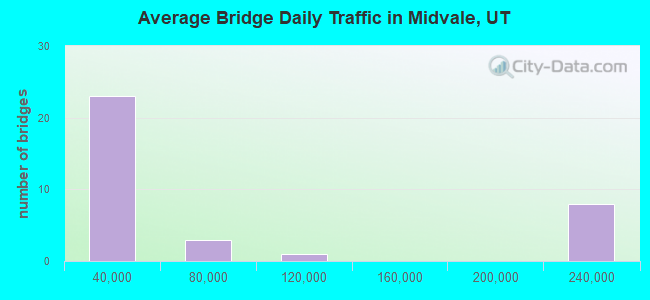
- 2,412,397Total average daily traffic
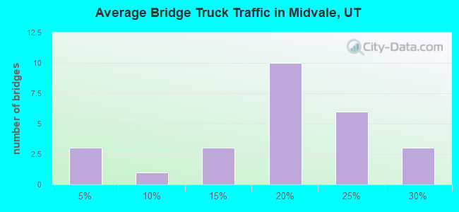
- 471,299Total average daily truck traffic
- National Bridge Inventory (NBI) Registered Bridges for Midvale
- No street view available for this location
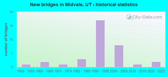
- New bridges - historical statistics
- 11950-1959
- 21960-1969
- 11970-1979
- 31980-1989
- 171990-1999
- 82000-2009
- 12010-2019
- 22020-2022
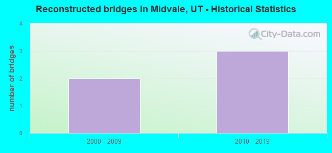
- Reconstructed bridges - Historical Statistics
- 22000-2009
- 32010-2019
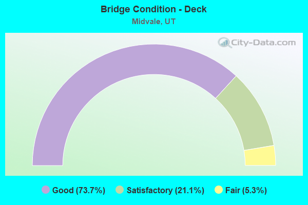
- Bridge Condition - Deck
- 73.7%Good
- 21.1%Satisfactory
- 5.3%Fair
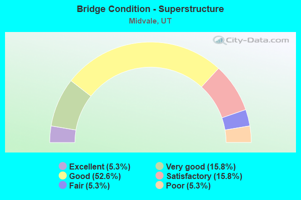
- Bridge Condition - Superstructure
- 5.3%Excellent
- 15.8%Very good
- 52.6%Good
- 15.8%Satisfactory
- 5.3%Fair
- 5.3%Poor
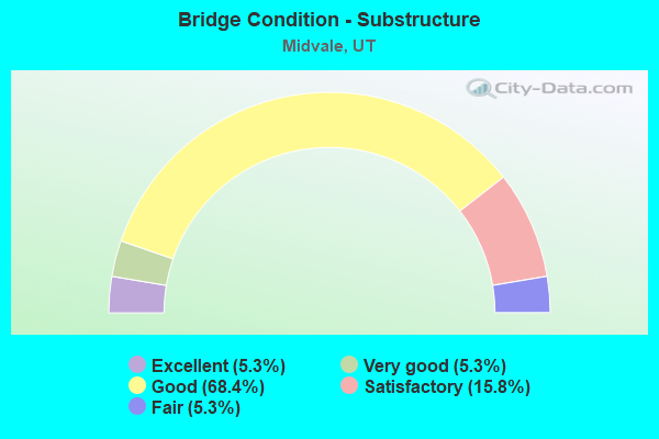
- Bridge Condition - Substructure
- 5.3%Excellent
- 5.3%Very good
- 68.4%Good
- 15.8%Satisfactory
- 5.3%Fair
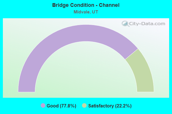
- Bridge Condition - Channel
- 77.8%Good
- 22.2%Satisfactory
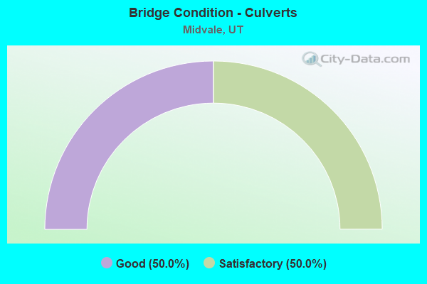
- Bridge Condition - Culverts
- 50.0%Good
- 50.0%Satisfactory
Find on map >> Show street view
Structure Number: 35014F, Location: 690 E. 6755 S., MIDVALE (Lat: 40.628550, Lng: -111.872544), Route carried "on" structure: City street , Year Built: 1982, Year Reconstructed: 2016, Status: Open, Structure Length: 0.73m (2.40ft), Average Daily Traffic: 1,197 (year 2020), Truck Traffic: 1%, Average Future Daily Traffic: 1,454 (year 2040), Design Load: HS 20+Mod, Features Intersected: JORDAN AND SALT LAKE C, Facility Carried by Structure: LARCHWOOD DRIVE
Minimum Vertical Clearance: 30+ m (98+ ft), Kilometerpoint: 0.059, Lanes on structure: 2, Owner: City or Municipal Highway Agency, Approaching Roadway Width: 11.8m (38.7ft), Skew: 3 degrees, Material/Design: Prestressed concrete, Design/Construction: Tee Beam, Number Of Spans In Main Unit: 1, Length of Maximum Span: 7.0m (23.0ft), Curb or Sidewalk Widths: Left: 2.8m (9.2ft), Right: 2.8m (9.2ft), Curb-To-Curb Width: 11.8m (38.7ft), Out-to-Out Width: 18.0m (59.1ft)
Condition: Deck: Good, Superstructure: Very good, Substructure: Good, Channel: Good, Operating Rating: 46.7 metric tons, Method Used To Determine Operating Rating: Load and Resistance Factor Rating (LRFR) rating reported by rating factor(RF) method using HL-93 loadings, Inventory Rating: 27.5 metric tons, Method Used To Determine Inventory Rating: Load and Resistance Factor Rating (LRFR) rating reported by rating factor(RF) method using HL-93 loadings, Structural Evaluation: Equal to present minimum criteria, Deck Geometry: Equal to present minimum criteria, Waterway Adequacy: Meets minimum limits, Approach Roadway Alignment: Equal to present desirable criteria, Designated Inspection Frequency: Every 24 months, Inspection Date: Febuary 2020, Deck Structure Type: Concrete Cast-file-Place, Wearing Surface/Protective System: Wearing Surface: Epoxy Overlay, Deck Protection: Epoxy Coated Reinforcing
Find on map >> Show street view
Structure Number: 35034D, Location: 270 E.7500 S., MIDVALE (Lat: 40.615003, Lng: -111.882014), Route carried "on" structure: City street 2095, Year Built: 2002, Status: Open, Structure Length: 0.94m (3.08ft), Average Daily Traffic: 500 (year 2020), Average Future Daily Traffic: 625 (year 2040), Design Load: HS 20+Mod, Features Intersected: JORDAN AND SALT LAKE C, Facility Carried by Structure: 7500 SOUTH STREET
Minimum Vertical Clearance: 30+ m (98+ ft), Kilometerpoint: 0.735, Lanes on structure: 2, Owner: City or Municipal Highway Agency, Approaching Roadway Width: 15.1m (49.5ft), Skew: 3 degrees, Material/Design: Concrete, Design/Construction: Frame, Number Of Spans In Main Unit: 1, Length of Maximum Span: 8.8m (28.9ft), Curb or Sidewalk Widths: Left: 2.4m (7.9ft), Right: 2.7m (8.9ft), Curb-To-Curb Width: 15.1m (49.5ft), Out-to-Out Width: 20.0m (65.6ft)
Condition: Deck: Good, Superstructure: Good, Substructure: Good, Channel: Good, Operating Rating: 35.3 metric tons, Method Used To Determine Operating Rating: Load and Resistance Factor Rating (LRFR) rating reported by rating factor(RF) method using HL-93 loadings, Inventory Rating: 32.4 metric tons, Method Used To Determine Inventory Rating: Load and Resistance Factor Rating (LRFR) rating reported by rating factor(RF) method using HL-93 loadings, Structural Evaluation: Better than present minimum criteria, Deck Geometry: Superior to present desirable criteria, Waterway Adequacy: Equal to present desirable criteria, Approach Roadway Alignment: Equal to present desirable criteria, Designated Inspection Frequency: Every 24 months, Inspection Date: January 2022, Deck Structure Type: Concrete Precast Panels, Wearing Surface/Protective System: Wearing Surface: Bituminous, Deck Protection: Epoxy Coated Reinforcing
Find on map >> Show street view
Structure Number: 35035F, Location: 150 E.8000 S., MIDVALE (Lat: 40.605800, Lng: -111.889000), Route carried "on" structure: City street 2090, Year Built: 1965, Status: Open, Structure Length: 0.75m (2.46ft), Average Daily Traffic: 500 (year 2020), Average Future Daily Traffic: 625 (year 2040), Design Load: HL 93, Features Intersected: JORDAN AND SALT LAKE C, Facility Carried by Structure: 8000 SOUTH STREET
Minimum Vertical Clearance: 30+ m (98+ ft), Kilometerpoint: 1.803, Lanes on structure: 2, Owner: City or Municipal Highway Agency, Approaching Roadway Width: 13.7m (44.9ft), Skew: 4 degrees, Material/Design: Prestressed concrete, Design/Construction: Tee Beam, Number Of Spans In Main Unit: 1, Length of Maximum Span: 7.2m (23.6ft), Curb or Sidewalk Widths: Left: 1.4m (4.6ft), Right: 1.4m (4.6ft), Curb-To-Curb Width: 13.7m (44.9ft), Out-to-Out Width: 17.2m (56.4ft)
Condition: Deck: Satisfactory, Superstructure: Poor, Substructure: Satisfactory, Channel: Good, Operating Rating: 32.4 metric tons, Method Used To Determine Operating Rating: Load and Resistance Factor Rating (LRFR) rating reported by rating factor(RF) method using HL-93 loadings, Inventory Rating: 19.4 metric tons, Method Used To Determine Inventory Rating: Load Factor (LF) rating reported by rating factor (RF) method using MS18 loading, Structural Evaluation: Meets minimum limits, Deck Geometry: Superior to present desirable criteria, Waterway Adequacy: Better than present minimum criteria, Approach Roadway Alignment: Equal to present desirable criteria, Designated Inspection Frequency: Every 24 months, Inspection Date: December 2021, Deck Structure Type: Concrete Precast Panels, Wearing Surface/Protective System: Wearing Surface: Bituminous
Find on map >> Show street view
Structure Number: 35037D, Location: 150 E. 7800 S., MIDVALE (Lat: 40.609547, Lng: -111.886061), Route carried "on" structure: City street 2092, Year Built: 2000, Status: Open, Structure Length: 0.80m (2.62ft), Average Daily Traffic: 11,804 (year 2020), Average Future Daily Traffic: 14,755 (year 2040), Design Load: HS 20+Mod, Features Intersected: JORDAN AND SALT LAKE C
Minimum Vertical Clearance: 30+ m (98+ ft), Kilometerpoint: 0.399, Lanes on structure: 2, Owner: City or Municipal Highway Agency, Approaching Roadway Width: 14.3m (46.9ft), Skew: 2 degrees, Material/Design: Concrete, Design/Construction: Frame, Number Of Spans In Main Unit: 1, Length of Maximum Span: 7.4m (24.3ft), Curb or Sidewalk Widths: Left: 2.4m (7.9ft), Right: 2.4m (7.9ft), Curb-To-Curb Width: 14.3m (46.9ft), Out-to-Out Width: 22.8m (74.8ft)
Condition: Deck: Satisfactory, Superstructure: Satisfactory, Substructure: Good, Channel: Good, Operating Rating: 32.4 metric tons, Method Used To Determine Operating Rating: Load and Resistance Factor Rating (LRFR) rating reported by rating factor(RF) method using HL-93 loadings, Inventory Rating: 19.8 metric tons, Method Used To Determine Inventory Rating: Load Factor (LF) rating reported by rating factor (RF) method using MS18 loading, Structural Evaluation: Somewhat better than minimum adequacy, Deck Geometry: Superior to present desirable criteria, Waterway Adequacy: Better than present minimum criteria, Approach Roadway Alignment: Equal to present minimum criteria, Designated Inspection Frequency: Every 24 months, Inspection Date: December 2021, Deck Structure Type: Concrete Precast Panels, Wearing Surface/Protective System: Wearing Surface: Bituminous, Deck Protection: Epoxy Coated Reinforcing
Find on map >> Show street view
Structure Number: 35043D, Location: 400 E. 7200 S., MIDVALE (Lat: 40.620742, Lng: -111.877492), Route carried "on" structure: City street 2116, Year Built: 1999, Status: Open, Structure Length: 0.75m (2.46ft), Average Daily Traffic: 21,008 (year 2020), Average Future Daily Traffic: 26,260 (year 2040), Design Load: HS 20+Mod, Features Intersected: JORDAN AND SALT LAKE C, Facility Carried by Structure: 7200 SOUTH STREET
Minimum Vertical Clearance: 30+ m (98+ ft), Kilometerpoint: 1.106, Lanes on structure: 5, Owner: City or Municipal Highway Agency, Approaching Roadway Width: 24.4m (80.1ft), Skew: 1 degrees, Material/Design: Concrete, Design/Construction: Frame, Number Of Spans In Main Unit: 1, Length of Maximum Span: 6.8m (22.3ft), Curb or Sidewalk Widths: Left: 2.1m (6.9ft), Right: 2.1m (6.9ft), Curb-To-Curb Width: 24.4m (80.1ft), Out-to-Out Width: 28.0m (91.9ft)
Condition: Deck: Satisfactory, Superstructure: Satisfactory, Substructure: Good, Channel: Good, Operating Rating: 59.0 metric tons, Method Used To Determine Operating Rating: Load and Resistance Factor Rating (LRFR) rating reported by rating factor(RF) method using HL-93 loadings, Inventory Rating: 32.4 metric tons, Method Used To Determine Inventory Rating: Load Factor (LF) rating reported by rating factor (RF) method using MS18 loading, Structural Evaluation: Equal to present minimum criteria, Deck Geometry: Superior to present desirable criteria, Waterway Adequacy: Better than present minimum criteria, Approach Roadway Alignment: Equal to present desirable criteria, Designated Inspection Frequency: Every 24 months, Inspection Date: January 2022, Deck Structure Type: Concrete Cast-file-Place, Wearing Surface/Protective System: Wearing Surface: Bituminous, Deck Protection: Epoxy Coated Reinforcing
Find on map >> Show street view
Structure Number: 35055D, Location: 740 EAST 7350 S., MIDVALE (Lat: 40.617611, Lng: -111.871481), Route carried "on" structure: City street , Year Built: 1970, Status: Open, Structure Length: 0.73m (2.40ft), Average Daily Traffic: 1,323 (year 2020), Truck Traffic: 1%, Average Future Daily Traffic: 1,607 (year 2040), Design Load: HL 93, Features Intersected: EAST JORDAN CANAL, Facility Carried by Structure: 7350 SOUTH STREET
Minimum Vertical Clearance: 30+ m (98+ ft), Kilometerpoint: 0.058, Lanes on structure: 2, Owner: City or Municipal Highway Agency, Approaching Roadway Width: 12.5m (41.0ft), Material/Design: Concrete, Design/Construction: Slab, Number Of Spans In Main Unit: 1, Length of Maximum Span: 6.7m (22.0ft), Curb or Sidewalk Widths: Left: 2.0m (6.6ft), Right: 0.0m, Curb-To-Curb Width: 12.5m (41.0ft), Out-to-Out Width: 15.2m (49.9ft)
Condition: Deck: Good, Superstructure: Good, Substructure: Good, Channel: Satisfactory, Operating Rating: 32.4 metric tons, Method Used To Determine Operating Rating: Load and Resistance Factor Rating (LRFR) rating reported by rating factor(RF) method using HL-93 loadings, Inventory Rating: 19.4 metric tons, Method Used To Determine Inventory Rating: Load Factor (LF) rating reported by rating factor (RF) method using MS18 loading, Structural Evaluation: Somewhat better than minimum adequacy, Deck Geometry: Better than present minimum criteria, Waterway Adequacy: Meets minimum limits, Approach Roadway Alignment: Equal to present minimum criteria, Designated Inspection Frequency: Every 24 months, Inspection Date: January 2022, Deck Structure Type: Concrete Cast-file-Place, Wearing Surface/Protective System: Wearing Surface: Bituminous
Find on map >> Show street view
Structure Number: 35160D, Location: 1250 E. 7180 S., MIDVALE (Lat: 40.620833, Lng: -111.856833), Route carried "on" structure: City street , Year Built: 1995, Status: Open, Structure Length: 0.98m (3.22ft), Average Daily Traffic: 6,552 (year 2020), Truck Traffic: 5%, Average Future Daily Traffic: 7,961 (year 2040), Design Load: HS 20+Mod, Features Intersected: LITTLE COTTONWOOD CREEK, Facility Carried by Structure: 7180 SOUTH STREET
Minimum Vertical Clearance: 30+ m (98+ ft), Kilometerpoint: 0.000, Lanes on structure: 2, Owner: City or Municipal Highway Agency, Approaching Roadway Width: 14.3m (46.9ft), Skew: 1 degrees, Material/Design: Concrete, Design/Construction: Frame, Number Of Spans In Main Unit: 1, Length of Maximum Span: 9.2m (30.2ft), Curb or Sidewalk Widths: Left: 1.8m (5.9ft), Right: 0.0m, Curb-To-Curb Width: 14.3m (46.9ft), Out-to-Out Width: 18.9m (62.0ft)
Condition: Deck: Fair, Superstructure: Fair, Substructure: Fair, Channel: Good, Operating Rating: 32.4 metric tons, Method Used To Determine Operating Rating: Load and Resistance Factor Rating (LRFR) rating reported by rating factor(RF) method using HL-93 loadings, Inventory Rating: 21.4 metric tons, Method Used To Determine Inventory Rating: Load Factor (LF) rating reported by rating factor (RF) method using MS18 loading, Structural Evaluation: Somewhat better than minimum adequacy, Deck Geometry: Superior to present desirable criteria, Waterway Adequacy: Equal to present desirable criteria, Approach Roadway Alignment: Equal to present desirable criteria, Designated Inspection Frequency: Every 24 months, Inspection Date: January 2022, Deck Structure Type: Concrete Precast Panels, Wearing Surface/Protective System: Wearing Surface: Bituminous
Find on map >> Show street view
Structure Number: 35186D, Location: 50 W. 8600 S., MIDVALE (Lat: 40.595022, Lng: -111.892381), Route carried "on" structure: City street , Year Built: 2003, Status: Open, Structure Length: 0.72m (2.36ft), Average Daily Traffic: 1,890 (year 2020), Truck Traffic: 2%, Average Future Daily Traffic: 2,296 (year 2040), Design Load: HS 20+Mod, Features Intersected: JORDAN AND SALT LAKE C, Facility Carried by Structure: 8600 SOUTH STREET
Minimum Vertical Clearance: 30+ m (98+ ft), Kilometerpoint: 0.040, Lanes on structure: 2, Owner: City or Municipal Highway Agency, Approaching Roadway Width: 8.2m (26.9ft), Material/Design: Concrete, Design/Construction: Culvert, Number Of Spans In Main Unit: 1, Length of Maximum Span: 6.7m (22.0ft), Curb or Sidewalk Widths: Left: 3.5m (11.5ft), Right: 3.5m (11.5ft), Curb-To-Curb Width: 8.2m (26.9ft), Out-to-Out Width: 16.9m (55.4ft)
Condition: Channel: Good, Culverts: Good, Operating Rating: 32.4 metric tons, Method Used To Determine Operating Rating: Load and Resistance Factor Rating (LRFR) rating reported by rating factor(RF) method using HL-93 loadings, Inventory Rating: 19.4 metric tons, Method Used To Determine Inventory Rating: Load Factor (LF) rating reported by rating factor (RF) method using MS18 loading, Structural Evaluation: Somewhat better than minimum adequacy, Deck Geometry: Meets minimum limits, Waterway Adequacy: Equal to present minimum criteria, Approach Roadway Alignment: Equal to present desirable criteria, Designated Inspection Frequency: Every 24 months, Inspection Date: December 2021, Deck Structure Type: Concrete Precast Panels, Wearing Surface/Protective System: Wearing Surface: Bituminous
Find on map >> Show street view
Structure Number: C 726, Location: 6550 SO.900 EAST MURRAY (Lat: 40.629458, Lng: -111.865925), Route carried "on" structure: State highway 71, Year Built: 1984, Status: Open, Structure Length: 11.95m (39.21ft), Average Daily Traffic: 18,677 (year 2020), Truck Traffic: 14%, Average Future Daily Traffic: 23,346 (year 2040), Design Load: HS 20+Mod, Features Intersected: I-215 EB AND WB
Minimum Vertical Clearance: 30+ m (98+ ft), Kilometerpoint: 21.268, Lanes on structure: 4, Lanes under structure: 10, Base Highway Network: Yes, Owner: State Highway Agency, Approaching Roadway Width: 23.8m (78.1ft), Material/Design: Steel continuous, Design/Construction: Stringer/Multi-beam, Number Of Spans In Main Unit: 2, Length of Maximum Span: 68.3m (224.1ft), Curb or Sidewalk Widths: Left: 1.2m (3.9ft), Right: 1.2m (3.9ft), Curb-To-Curb Width: 24.6m (80.7ft), Out-to-Out Width: 31.6m (103.7ft)
Condition: Deck: Satisfactory, Superstructure: Satisfactory, Substructure: Satisfactory, Operating Rating: 41.5 metric tons, Method Used To Determine Operating Rating: Load and Resistance Factor Rating (LRFR) rating reported by rating factor(RF) method using HL-93 loadings, Inventory Rating: 34.3 metric tons, Method Used To Determine Inventory Rating: Load Factor (LF) rating reported by rating factor (RF) method using MS18 loading, Structural Evaluation: Equal to present minimum criteria, Deck Geometry: Superior to present desirable criteria, Underclear: Somewhat better than minimum adequacy, Approach Roadway Alignment: Equal to present desirable criteria, Designated Inspection Frequency: Every 24 months, Inspection Date: September 2020, Deck Structure Type: Concrete Cast-file-Place, Wearing Surface/Protective System: Wearing Surface: Bituminous, Deck Protection: Epoxy Coated Reinforcing
Find on map >> Show street view
Structure Number: E1064, Location: APPROX. 8250 SO.STATE ST. (Lat: 40.601614, Lng: -111.890772), Route carried "on" structure: US 89, Year Built: 1956, Status: Open, Structure Length: 1.04m (3.41ft), Average Daily Traffic: 22,274 (year 2020), Truck Traffic: 10%, Average Future Daily Traffic: 27,843 (year 2040), Design Load: HS 20+Mod, Features Intersected: JORDAN & SALT LAKE CANAL
Minimum Vertical Clearance: 30+ m (98+ ft), Kilometerpoint: 592.617, Lanes on structure: 4, Owner: State Highway Agency, Approaching Roadway Width: 17.1m (56.1ft), Skew: 6 degrees, Material/Design: Concrete, Design/Construction: Culvert, Number Of Spans In Main Unit: 1, Length of Maximum Span: 9.8m (32.2ft), Curb-To-Curb Width: 17.1m (56.1ft), Out-to-Out Width: 17.1m (56.1ft)
Condition: Channel: Satisfactory, Culverts: Satisfactory, Operating Rating: 39.2 metric tons, Method Used To Determine Operating Rating: Load and Resistance Factor Rating (LRFR) rating reported by rating factor(RF) method using HL-93 loadings, Inventory Rating: 17.8 metric tons, Method Used To Determine Inventory Rating: Load Factor (LF) rating reported by rating factor (RF) method using MS18 loading, Structural Evaluation: Meets minimum limits, Deck Geometry: Somewhat better than minimum adequacy, Waterway Adequacy: Equal to present minimum criteria, Approach Roadway Alignment: Equal to present desirable criteria, Designated Inspection Frequency: Every 24 months, Inspection Date: October 2020, Deck Structure Type: Concrete Cast-file-Place, Wearing Surface/Protective System: Wearing Surface: Bituminous
Find on map >> Show street view
Structure Number: 1C 827, Location: 400 W.7200 SO.IN MIDVALE (Lat: 40.619900, Lng: -111.903703), Route carried "on" structure: Ramp Interstate 15, Year Built: 1998, Status: Open, Structure Length: 13.60m (44.62ft), Average Daily Traffic: 23,546 (year 2020), Truck Traffic: 25%, Average Future Daily Traffic: 29,433 (year 2040), Design Load: HS 25 or greater, Features Intersected: SR 48, 7200 SOUTH STREET
Minimum Vertical Clearance: 30+ m (98+ ft), Kilometerpoint: 0.470, Lanes on structure: 2, Lanes under structure: 10, Owner: State Highway Agency, Approaching Roadway Width: 11.8m (38.7ft), Material/Design: Steel continuous, Design/Construction: Stringer/Multi-beam, Number Of Spans In Main Unit: 2, Length of Maximum Span: 68.0m (223.1ft), Curb-To-Curb Width: 12.0m (39.4ft), Out-to-Out Width: 12.6m (41.3ft)
Condition: Deck: Good, Superstructure: Good, Substructure: Good, Operating Rating: 75.5 metric tons, Method Used To Determine Operating Rating: Load and Resistance Factor Rating (LRFR) rating reported by rating factor(RF) method using HL-93 loadings, Inventory Rating: 36.0 metric tons, Method Used To Determine Inventory Rating: Load and Resistance Factor Rating (LRFR) rating reported by rating factor(RF) method using HL-93 loadings, Structural Evaluation: Better than present minimum criteria, Deck Geometry: Superior to present desirable criteria, Underclear: High priority of corrective action, Approach Roadway Alignment: Equal to present desirable criteria, Designated Inspection Frequency: Every 24 months, Inspection Date: October 2020, Deck Structure Type: Concrete Cast-file-Place, Wearing Surface/Protective System: Wearing Surface: Epoxy Overlay, Deck Protection: Epoxy Coated Reinforcing
Find on map >> Show street view
Structure Number: 1F 610N, Location: 7200 SOUTH INTERCHANGE (Lat: 40.620425, Lng: -111.904033), Route carried "on" structure: Interstate 15, Year Built: 2000, Status: Open, Structure Length: 6.85m (22.47ft), Average Daily Traffic: 236,512 (year 2020), Truck Traffic: 19%, Average Future Daily Traffic: 295,640 (year 2040), Design Load: HS 25 or greater, Features Intersected: SR-48,7200 SOUTH STREET
Minimum Vertical Clearance: 30+ m (98+ ft), Kilometerpoint: 479.978, Lanes on structure: 5, Lanes under structure: 6, Base Highway Network: Yes, Owner: State Highway Agency, Approaching Roadway Width: 24.5m (80.4ft), Skew: 1 degrees, Material/Design: Prestressed concrete, Design/Construction: Stringer/Multi-beam, Number Of Spans In Main Unit: 1, Length of Maximum Span: 65.5m (214.9ft), Curb-To-Curb Width: 25.1m (82.3ft), Out-to-Out Width: 25.9m (85.0ft)
Condition: Deck: Good, Superstructure: Good, Substructure: Good, Operating Rating: 58.3 metric tons, Method Used To Determine Operating Rating: Load and Resistance Factor Rating (LRFR) rating reported by rating factor(RF) method using HL-93 loadings, Inventory Rating: 42.1 metric tons, Method Used To Determine Inventory Rating: Load and Resistance Factor Rating (LRFR) rating reported by rating factor(RF) method using HL-93 loadings, Structural Evaluation: Better than present minimum criteria, Deck Geometry: Better than present minimum criteria, Underclear: Somewhat better than minimum adequacy, Approach Roadway Alignment: Equal to present desirable criteria, Designated Inspection Frequency: Every 24 months, Inspection Date: October 2020, Deck Structure Type: Concrete Cast-file-Place, Wearing Surface/Protective System: Deck Protection: Epoxy Coated Reinforcing
Find on map >> Show street view
Structure Number: 1F 611N, Location: 0.1 MI.SO.OF 6400 SO.ST. (Lat: 40.629794, Lng: -111.903806), Route carried "on" structure: Interstate 15, Year Built: 2000, Status: Open, Structure Length: 6.89m (22.60ft), Average Daily Traffic: 236,512 (year 2020), Truck Traffic: 19%, Average Future Daily Traffic: 295,640 (year 2040), Design Load: HS 25 or greater, Features Intersected: UTA,LIGHT RAIL SPUR LINE
Minimum Vertical Clearance: 30.18m (99.02ft), Kilometerpoint: 480.850, Lanes on structure: 5, Base Highway Network: Yes, Owner: State Highway Agency, Approaching Roadway Width: 25.1m (82.3ft), Skew: 2 degrees, Material/Design: Prestressed concrete, Design/Construction: Stringer/Multi-beam, Number Of Spans In Main Unit: 1, Length of Maximum Span: 65.5m (214.9ft), Curb-To-Curb Width: 25.1m (82.3ft), Out-to-Out Width: 25.9m (85.0ft)
Condition: Deck: Good, Superstructure: Good, Substructure: Good, Operating Rating: 32.7 metric tons, Method Used To Determine Operating Rating: Load and Resistance Factor Rating (LRFR) rating reported by rating factor(RF) method using HL-93 loadings, Inventory Rating: 22.4 metric tons, Method Used To Determine Inventory Rating: Load and Resistance Factor Rating (LRFR) rating reported by rating factor(RF) method using HL-93 loadings, Structural Evaluation: Somewhat better than minimum adequacy, Deck Geometry: Better than present minimum criteria, Underclear: Superior to present desirable criteria, Approach Roadway Alignment: Equal to present desirable criteria, Designated Inspection Frequency: Every 24 months, Inspection Date: October 2020, Deck Structure Type: Concrete Cast-file-Place, Wearing Surface/Protective System: Deck Protection: Epoxy Coated Reinforcing
Find on map >> Show street view
Structure Number: 1F 647N, Location: Wasatch Street 400 West (Lat: 40.605694, Lng: -111.904781), Route carried "on" structure: Interstate 15, Year Built: 1999, Status: Open, Structure Length: 3.85m (12.63ft), Average Daily Traffic: 227,001 (year 2020), Truck Traffic: 22%, Average Future Daily Traffic: 283,751 (year 2040), Design Load: HS 25 or greater, Features Intersected: 8000 SOUTH ST., WASATCH
Minimum Vertical Clearance: 30+ m (98+ ft), Kilometerpoint: 478.317, Lanes on structure: 6, Lanes under structure: 2, Base Highway Network: Yes, Owner: State Highway Agency, Approaching Roadway Width: 30.0m (98.4ft), Skew: 30 degrees, Material/Design: Prestressed concrete, Design/Construction: Stringer/Multi-beam, Number Of Spans In Main Unit: 3, Length of Maximum Span: 21.3m (69.9ft), Curb-To-Curb Width: 28.7m (94.2ft), Out-to-Out Width: 29.5m (96.8ft)
Condition: Deck: Good, Superstructure: Very good, Substructure: Good, Operating Rating: 53.5 metric tons, Method Used To Determine Operating Rating: Load and Resistance Factor Rating (LRFR) rating reported by rating factor(RF) method using HL-93 loadings, Inventory Rating: 27.5 metric tons, Method Used To Determine Inventory Rating: Load Factor (LF) rating reported by rating factor (RF) method using MS18 loading, Structural Evaluation: Equal to present minimum criteria, Deck Geometry: Better than present minimum criteria, Underclear: Equal to present minimum criteria, Approach Roadway Alignment: Equal to present desirable criteria, Designated Inspection Frequency: Every 24 months, Inspection Date: October 2020, Deck Structure Type: Concrete Cast-file-Place, Wearing Surface/Protective System: Wearing Surface: Other, Deck Protection: Epoxy Coated Reinforcing
Find on map >> Show street view
Structure Number: 1F 648N, Location: 400 W.CENTER ST.-MIDVALE (Lat: 40.610586, Lng: -111.905747), Route carried "on" structure: Interstate 15, Year Built: 1999, Status: Open, Structure Length: 5.92m (19.42ft), Average Daily Traffic: 227,001 (year 2020), Truck Traffic: 22%, Average Future Daily Traffic: 283,751 (year 2040), Design Load: HS 25 or greater, Features Intersected: 7800 SOUTH ST.,CENTER ST
Minimum Vertical Clearance: 30+ m (98+ ft), Kilometerpoint: 478.866, Lanes on structure: 5, Lanes under structure: 4, Base Highway Network: Yes, Owner: State Highway Agency, Approaching Roadway Width: 28.7m (94.2ft), Skew: 30 degrees, Material/Design: Prestressed concrete continuous, Design/Construction: Stringer/Multi-beam, Number Of Spans In Main Unit: 3, Length of Maximum Span: 29.5m (96.8ft), Curb-To-Curb Width: 28.7m (94.2ft), Out-to-Out Width: 29.5m (96.8ft)
Condition: Deck: Good, Superstructure: Good, Substructure: Good, Operating Rating: 63.2 metric tons, Method Used To Determine Operating Rating: Load and Resistance Factor Rating (LRFR) rating reported by rating factor(RF) method using HL-93 loadings, Inventory Rating: 53.1 metric tons, Method Used To Determine Inventory Rating: Load Factor (LF) rating reported by rating factor (RF) method using MS18 loading, Structural Evaluation: Better than present minimum criteria, Deck Geometry: Superior to present desirable criteria, Underclear: High priority of corrective action, Approach Roadway Alignment: Equal to present desirable criteria, Designated Inspection Frequency: Every 24 months, Inspection Date: October 2020, Deck Structure Type: Concrete Precast Panels, Wearing Surface/Protective System: Wearing Surface: Latex Concrete, Deck Protection: Epoxy Coated Reinforcing
Find on map >> Show street view
Structure Number: 3C 828, Location: 500 W.7200 SO.IN MIDVALE (Lat: 40.621250, Lng: -111.904803), Route carried "on" structure: Ramp Interstate 15, Year Built: 1998, Year Reconstructed: 2011, Status: Open, Structure Length: 13.28m (43.57ft), Average Daily Traffic: 23,546 (year 2020), Truck Traffic: 25%, Average Future Daily Traffic: 29,433 (year 2040), Design Load: HS 25 or greater, Features Intersected: SR-48,7200 SOUTH STREET
Minimum Vertical Clearance: 30+ m (98+ ft), Kilometerpoint: 1.249, Lanes on structure: 2, Lanes under structure: 9, Owner: State Highway Agency, Approaching Roadway Width: 15.7m (51.5ft), Material/Design: Steel continuous, Design/Construction: Stringer/Multi-beam, Number Of Spans In Main Unit: 2, Length of Maximum Span: 65.5m (214.9ft), Curb-To-Curb Width: 15.7m (51.5ft), Out-to-Out Width: 16.8m (55.1ft)
Condition: Deck: Good, Superstructure: Good, Substructure: Good, Operating Rating: 56.7 metric tons, Method Used To Determine Operating Rating: Load and Resistance Factor Rating (LRFR) rating reported by rating factor(RF) method using HL-93 loadings, Inventory Rating: 40.5 metric tons, Method Used To Determine Inventory Rating: Load Factor (LF) rating reported by rating factor (RF) method using MS18 loading, Structural Evaluation: Better than present minimum criteria, Deck Geometry: Superior to present desirable criteria, Underclear: High priority of corrective action, Approach Roadway Alignment: Equal to present desirable criteria, Designated Inspection Frequency: Every 24 months, Inspection Date: October 2020, Deck Structure Type: Concrete Cast-file-Place, Wearing Surface/Protective System: Wearing Surface: Latex Concrete, Deck Protection: Epoxy Coated Reinforcing
Find on map >> Show street view
Structure Number: 3C 83, Location: 0.2 MI.SO.6400 SOUTH ST. (Lat: 40.629414, Lng: -111.903983), Route carried "on" structure: Ramp Interstate 15, Year Built: 1998, Year Reconstructed: 2019, Status: Open, Structure Length: 21.32m (69.95ft), Average Daily Traffic: 23,546 (year 2020), Truck Traffic: 25%, Average Future Daily Traffic: 29,433 (year 2040), Design Load: HS 25 or greater, Features Intersected: UNION PACIFIC RAILROAD
Minimum Vertical Clearance: 30+ m (98+ ft), Kilometerpoint: 0.324, Lanes on structure: 2, Owner: State Highway Agency, Approaching Roadway Width: 12.2m (40.0ft), Skew: 6 degrees, Material/Design: Steel continuous, Design/Construction: Stringer/Multi-beam, Number Of Spans In Main Unit: 3, Length of Maximum Span: 102.4m (336.0ft), Curb-To-Curb Width: 12.2m (40.0ft), Out-to-Out Width: 13.1m (43.0ft)
Condition: Deck: Good, Superstructure: Good, Substructure: Satisfactory, Operating Rating: 53.8 metric tons, Method Used To Determine Operating Rating: Load and Resistance Factor Rating (LRFR) rating reported by rating factor(RF) method using HL-93 loadings, Inventory Rating: 36.9 metric tons, Method Used To Determine Inventory Rating: Load and Resistance Factor Rating (LRFR) rating reported by rating factor(RF) method using HL-93 loadings, Structural Evaluation: Equal to present minimum criteria, Deck Geometry: Superior to present desirable criteria, Underclear: Equal to present desirable criteria, Approach Roadway Alignment: Equal to present desirable criteria, Designated Inspection Frequency: Every 24 months, Inspection Date: October 2020, Deck Structure Type: Concrete Cast-file-Place, Wearing Surface/Protective System: Wearing Surface: Integral Concrete, Deck Protection: Epoxy Coated Reinforcing
Find on map >> Show street view
Structure Number: 3F 610S, Location: 7200 SOUTH INTERCHANGE (Lat: 40.621169, Lng: -111.904078), Route carried "on" structure: Interstate 15, Year Built: 1998, Year Reconstructed: 2019, Status: Open, Structure Length: 6.85m (22.47ft), Average Daily Traffic: 227,001 (year 2020), Truck Traffic: 22%, Average Future Daily Traffic: 283,751 (year 2040), Design Load: HS 25 or greater, Features Intersected: SR-48,7200 SOUTH STREET
Minimum Vertical Clearance: 30+ m (98+ ft), Kilometerpoint: 479.875, Lanes on structure: 5, Lanes under structure: 10, Base Highway Network: Yes, Owner: State Highway Agency, Approaching Roadway Width: 21.5m (70.5ft), Skew: 1 degrees, Material/Design: Prestressed concrete, Design/Construction: Stringer/Multi-beam, Number Of Spans In Main Unit: 1, Length of Maximum Span: 65.5m (214.9ft), Curb-To-Curb Width: 25.2m (82.7ft), Out-to-Out Width: 26.0m (85.3ft)
Condition: Deck: Good, Superstructure: Very good, Substructure: Very good, Operating Rating: 59.6 metric tons, Method Used To Determine Operating Rating: Load and Resistance Factor Rating (LRFR) rating reported by rating factor(RF) method using HL-93 loadings, Inventory Rating: 43.4 metric tons, Method Used To Determine Inventory Rating: Load and Resistance Factor Rating (LRFR) rating reported by rating factor(RF) method using HL-93 loadings, Structural Evaluation: Equal to present desirable criteria, Deck Geometry: Better than present minimum criteria, Underclear: Equal to present minimum criteria, Approach Roadway Alignment: Equal to present desirable criteria, Designated Inspection Frequency: Every 24 months, Inspection Date: October 2020, Deck Structure Type: Concrete Precast Panels, Wearing Surface/Protective System: Deck Protection: Epoxy Coated Reinforcing
Find on map >> Show street view
Structure Number: 3F 647S, Location: 400 W.8000 SO.IN MIDVALE (Lat: 40.606186, Lng: -111.905214), Route carried "on" structure: Interstate 15, Year Built: 1998, Year Reconstructed: 2009, Status: Open, Structure Length: 3.85m (12.63ft), Average Daily Traffic: 227,001 (year 2020), Truck Traffic: 22%, Average Future Daily Traffic: 283,751 (year 2040), Design Load: HS 25 or greater, Features Intersected: 8000 SOUTH ST.(WASATCH)
Minimum Vertical Clearance: 30+ m (98+ ft), Kilometerpoint: 478.183, Lanes on structure: 7, Lanes under structure: 2, Base Highway Network: Yes, Owner: State Highway Agency, Approaching Roadway Width: 31.7m (104.0ft), Skew: 30 degrees, Material/Design: Prestressed concrete continuous, Design/Construction: Stringer/Multi-beam, Number Of Spans In Main Unit: 3, Length of Maximum Span: 21.3m (69.9ft), Curb-To-Curb Width: 32.3m (106.0ft), Out-to-Out Width: 33.2m (108.9ft)
Condition: Deck: Good, Superstructure: Good, Substructure: Good, Operating Rating: 62.5 metric tons, Method Used To Determine Operating Rating: Load and Resistance Factor Rating (LRFR) rating reported by rating factor(RF) method using HL-93 loadings, Inventory Rating: 25.9 metric tons, Method Used To Determine Inventory Rating: Load Factor (LF) rating reported by rating factor (RF) method using MS18 loading, Structural Evaluation: Equal to present minimum criteria, Deck Geometry: Better than present minimum criteria, Underclear: Equal to present minimum criteria, Approach Roadway Alignment: Equal to present desirable criteria, Designated Inspection Frequency: Every 24 months, Inspection Date: October 2020, Deck Structure Type: Concrete Precast Panels, Wearing Surface/Protective System: Wearing Surface: Epoxy Overlay, Deck Protection: Epoxy Coated Reinforcing
Find on map >> Show street view
Structure Number: 3F 648S, Location: 400 W.7800 SO.IN MIDVALE (Lat: 40.611236, Lng: -111.906172), Route carried "on" structure: Interstate 15, Year Built: 1998, Status: Open, Structure Length: 5.92m (19.42ft), Average Daily Traffic: 227,001 (year 2020), Truck Traffic: 22%, Average Future Daily Traffic: 283,751 (year 2040), Design Load: HS 25 or greater, Features Intersected: 7800 SOUTH ST.,CENTER ST
Minimum Vertical Clearance: 30+ m (98+ ft), Kilometerpoint: 478.750, Lanes on structure: 7, Lanes under structure: 4, Base Highway Network: Yes, Owner: State Highway Agency, Approaching Roadway Width: 30.9m (101.4ft), Skew: 30 degrees, Material/Design: Prestressed concrete continuous, Design/Construction: Stringer/Multi-beam, Number Of Spans In Main Unit: 3, Length of Maximum Span: 29.9m (98.1ft), Curb-To-Curb Width: 31.1m (102.0ft), Out-to-Out Width: 31.9m (104.7ft)
Condition: Deck: Good, Superstructure: Good, Substructure: Good, Operating Rating: 45.7 metric tons, Method Used To Determine Operating Rating: Load and Resistance Factor Rating (LRFR) rating reported by rating factor(RF) method using HL-93 loadings, Inventory Rating: 44.7 metric tons, Method Used To Determine Inventory Rating: Load Factor (LF) rating reported by rating factor (RF) method using MS18 loading, Structural Evaluation: Better than present minimum criteria, Deck Geometry: Equal to present minimum criteria, Underclear: Meets minimum limits, Approach Roadway Alignment: Equal to present desirable criteria, Designated Inspection Frequency: Every 24 months, Inspection Date: October 2020, Deck Structure Type: Concrete Precast Panels, Wearing Surface/Protective System: Wearing Surface: Latex Concrete, Deck Protection: Epoxy Coated Reinforcing
Find on map >> Show street view
Structure Number: 1F 92, Location: I-15 NB over 8000 S (Lat: 40.606000, Lng: -111.905000), Route carried "on" structure: Interstate 15, Year Built: 2021, Status: Open, Structure Length: 3.67m (12.04ft), Average Daily Traffic: 227,001 (year 2020), Truck Traffic: 22%, Average Future Daily Traffic: 283,751 (year 2040), Design Load: HL 93, Features Intersected: 8000 S
Minimum Vertical Clearance: 30+ m (98+ ft), Kilometerpoint: 477.814, Lanes on structure: 3, Lanes under structure: 2, Base Highway Network: Yes, Owner: State Highway Agency, Approaching Roadway Width: 18.3m (60.0ft), Material/Design: Prestressed concrete, Design/Construction: Stringer/Multi-beam, Number Of Spans In Main Unit: 3, Length of Maximum Span: 21.0m (68.9ft), Curb-To-Curb Width: 18.3m (60.0ft), Out-to-Out Width: 19.1m (62.7ft)
Condition: Deck: Good, Superstructure: Excellent, Substructure: Excellent, Operating Rating: 61.6 metric tons, Method Used To Determine Operating Rating: Load and Resistance Factor Rating (LRFR) rating reported by rating factor(RF) method using HL-93 loadings, Inventory Rating: 32.4 metric tons, Method Used To Determine Inventory Rating: Load and Resistance Factor Rating (LRFR) rating reported by rating factor(RF) method using HL-93 loadings, Structural Evaluation: Equal to present desirable criteria, Deck Geometry: Better than present minimum criteria, Underclear: Equal to present minimum criteria, Approach Roadway Alignment: Equal to present desirable criteria, Designated Inspection Frequency: Every 24 months, Inspection Date: January 2021, Deck Structure Type: Concrete Cast-file-Place, Wearing Surface/Protective System: Wearing Surface: Other, Deck Protection: Epoxy Coated Reinforcing
Find on map >> Show street view
Structure Number: C 441, Location: 7200 SOUTH WEST OF I-15 (Lat: 40.620842, Lng: -111.905472), Route carried "under" structure: State highway 48, Year Built: 1967, Structure Length: 0. m, Average Daily Traffic: 44,009 (year 2020), Truck Traffic: 15%, Features Intersected: SR-48, Facility Carried by Structure: UNION PACIFIC RR
Minimum Vertical Clearance: 4.60m (15.09ft), Kilometerpoint: 6.176, Material/Design: Steel continuous, Design/Construction: Stringer/Multi-beam, Length of Maximum Span: 12.2m (40.0ft)
Find on map >> Show street view
Structure Number: C 726, Location: 6550 SO.900 EAST MURRAY (Lat: 40.629458, Lng: -111.865925), Route carried "under" structure: Interstate 215, Year Built: 1984, Structure Length: 0. m, Average Daily Traffic: 105,506 (year 2020), Truck Traffic: 15%, Features Intersected: I-215 EB AND WB, Facility Carried by Structure: SR-71 (900E.ST)
Minimum Vertical Clearance: 4.93m (16.17ft), Kilometerpoint: 15.253, Lanes on structure: 4, Lanes under structure: 10, Material/Design: Steel continuous, Design/Construction: Stringer/Multi-beam, Length of Maximum Span: 68.3m (224.1ft)
Find on map >> Show street view
Structure Number: C 942, Location: 7850 So.State St.,Midvale (Lat: 40.608253, Lng: -111.890772), Route carried "under" structure: US 89, Year Built: 2008, Structure Length: 0. m, Average Daily Traffic: 30,743 (year 2020), Truck Traffic: 10%, Features Intersected: US-89 (SR-89),STATE ST., Facility Carried by Structure: UTA, LIGHT RAIL
Minimum Vertical Clearance: 5.03m (16.50ft), Kilometerpoint: 593.354, Lanes under structure: 6, Material/Design: Steel continuous, Design/Construction: Girder and Floorbeam System, Length of Maximum Span: 29.5m (96.8ft)
Find on map >> Show street view
Structure Number: F 779, Location: At 7200 So.,I-15 Intchg. (Lat: 40.620842, Lng: -111.905325), Route carried "under" structure: State highway 48, Year Built: 2011, Structure Length: 0. m, Average Daily Traffic: 44,009 (year 2020), Truck Traffic: 15%, Features Intersected: SR-48, 7200 SOUTH ST., Facility Carried by Structure: UTA, FRONT RUNNER
Minimum Vertical Clearance: 5.28m (17.32ft), Kilometerpoint: 6.188, Lanes under structure: 5, Material/Design: Prestressed concrete, Design/Construction: Box Beam or Girders - Multiple, Length of Maximum Span: 22.1m (72.5ft)
Find on map >> Show street view
Structure Number: F 788, Location: 7200 South 600 West (Lat: 40.620869, Lng: -111.907583), Route carried "under" structure: State highway 48, Year Built: 2009, Structure Length: 0. m, Average Daily Traffic: 44,009 (year 2020), Truck Traffic: 15%, Features Intersected: SR-48,(7200 SOUTH), Facility Carried by Structure: UTA, MID-VALLEY
Minimum Vertical Clearance: 4.92m (16.14ft), Kilometerpoint: 5.997, Material/Design: Prestressed concrete, Design/Construction: Box Beam or Girders - Multiple, Length of Maximum Span: 16.5m (54.1ft)
Find on map >> Show street view
Structure Number: 1C 827, Location: 400 W.7200 SO.IN MIDVALE (Lat: 40.619900, Lng: -111.903703), Route carried "under" structure: State highway 48, Year Built: 1998, Structure Length: 0. m, Average Daily Traffic: 33,663 (year 2020), Truck Traffic: 15%, Features Intersected: SR 48, 7200 SOUTH STREET, Facility Carried by Structure: Rp.I-15NB TO I-215
Minimum Vertical Clearance: 6.31m (20.70ft), Kilometerpoint: 21.350, Lanes on structure: 2, Lanes under structure: 10, Material/Design: Steel continuous, Design/Construction: Stringer/Multi-beam, Length of Maximum Span: 68.0m (223.1ft)
Find on map >> Show street view
Structure Number: 1F 610N, Location: 7200 SOUTH INTERCHANGE (Lat: 40.620425, Lng: -111.904033), Route carried "under" structure: State highway 48, Year Built: 2000, Structure Length: 0. m, Average Daily Traffic: 33,663 (year 2020), Truck Traffic: 15%, Features Intersected: SR-48,7200 SOUTH STREET, Facility Carried by Structure: I-15 (SR-15) NBL
Minimum Vertical Clearance: 5.46m (17.91ft), Kilometerpoint: 19.312, Lanes on structure: 5, Lanes under structure: 6, Material/Design: Prestressed concrete, Design/Construction: Stringer/Multi-beam, Length of Maximum Span: 65.5m (214.9ft)
Find on map >> Show street view
Structure Number: 1F 647N, Location: Wasatch Street 400 West (Lat: 40.605694, Lng: -111.904781), Route carried "under" structure: City street 2090, Year Built: 1999, Structure Length: 0. m, Average Daily Traffic: 500 (year 2020), Features Intersected: 8000 SOUTH ST., WASATCH, Facility Carried by Structure: I-15 (SR-15) NBL
Minimum Vertical Clearance: 5.08m (16.67ft), Kilometerpoint: 0.000, Lanes on structure: 6, Lanes under structure: 2, Material/Design: Prestressed concrete, Design/Construction: Stringer/Multi-beam, Length of Maximum Span: 21.3m (69.9ft)
Find on map >> Show street view
Structure Number: 1F 648N, Location: 400 W.CENTER ST.-MIDVALE (Lat: 40.610586, Lng: -111.905747), Route carried "under" structure: City street 2114, Year Built: 1999, Structure Length: 0. m, Average Daily Traffic: 8,288 (year 2020), Features Intersected: 7800 SOUTH ST.,CENTER ST, Facility Carried by Structure: I-15 (SR-15) NBL
Minimum Vertical Clearance: 4.95m (16.24ft), Kilometerpoint: 0.000, Lanes on structure: 5, Lanes under structure: 4, Material/Design: Prestressed concrete continuous, Design/Construction: Stringer/Multi-beam, Length of Maximum Span: 29.5m (96.8ft)
Find on map >> Show street view
Structure Number: 3C 828, Location: 500 W.7200 SO.IN MIDVALE (Lat: 40.621250, Lng: -111.904803), Route carried "under" structure: State highway 48, Year Built: 1998, Structure Length: 0. m, Average Daily Traffic: 33,663 (year 2020), Truck Traffic: 15%, Features Intersected: SR-48,7200 SOUTH STREET, Facility Carried by Structure: RP.I215EB TO I15SB
Minimum Vertical Clearance: 5.18m (16.99ft), Kilometerpoint: 19.312, Lanes on structure: 2, Lanes under structure: 9, Material/Design: Steel continuous, Design/Construction: Stringer/Multi-beam, Length of Maximum Span: 65.5m (214.9ft)
Find on map >> Show street view
Structure Number: 3F 610S, Location: 7200 SOUTH INTERCHANGE (Lat: 40.621169, Lng: -111.904078), Route carried "under" structure: State highway 48, Year Built: 1998, Structure Length: 0. m, Average Daily Traffic: 33,663 (year 2020), Truck Traffic: 15%, Features Intersected: SR-48,7200 SOUTH STREET, Facility Carried by Structure: I-15 (SR-15) SBL
Minimum Vertical Clearance: 5.72m (18.77ft), Kilometerpoint: 19.293, Lanes on structure: 5, Lanes under structure: 10, Material/Design: Prestressed concrete, Design/Construction: Stringer/Multi-beam, Length of Maximum Span: 65.5m (214.9ft)
Find on map >> Show street view
Structure Number: 3F 647S, Location: 400 W.8000 SO.IN MIDVALE (Lat: 40.606186, Lng: -111.905214), Route carried "under" structure: City street 2090, Year Built: 1998, Structure Length: 0. m, Average Daily Traffic: 500 (year 2020), Features Intersected: 8000 SOUTH ST.(WASATCH), Facility Carried by Structure: I-15 (SR-15) SBL
Minimum Vertical Clearance: 6.20m (20.34ft), Kilometerpoint: 0.000, Lanes on structure: 7, Lanes under structure: 2, Material/Design: Prestressed concrete continuous, Design/Construction: Stringer/Multi-beam, Length of Maximum Span: 21.3m (69.9ft)
Find on map >> Show street view
Structure Number: 3F 648S, Location: 400 W.7800 SO.IN MIDVALE (Lat: 40.611236, Lng: -111.906172), Route carried "under" structure: City street 2114, Year Built: 1998, Structure Length: 0. m, Average Daily Traffic: 8,288 (year 2020), Features Intersected: 7800 SOUTH ST.,CENTER ST, Facility Carried by Structure: I-15 (SR-15) SBL
Minimum Vertical Clearance: 6.20m (20.34ft), Kilometerpoint: 0.000, Lanes on structure: 7, Lanes under structure: 4, Material/Design: Prestressed concrete continuous, Design/Construction: Stringer/Multi-beam, Length of Maximum Span: 29.9m (98.1ft)
Find on map >> Show street view
Structure Number: 1F 92, Location: I-15 NB over 8000 S (Lat: 40.606000, Lng: -111.905000), Route carried "under" structure: City street 2090, Year Built: 2021, Structure Length: 0. m, Average Daily Traffic: 500 (year 2020), Features Intersected: 8000 S, Facility Carried by Structure: I-15 NB to I-215
Minimum Vertical Clearance: 5.13m (16.83ft), Kilometerpoint: 0.000, Lanes on structure: 3, Lanes under structure: 2, Material/Design: Prestressed concrete, Design/Construction: Stringer/Multi-beam, Length of Maximum Span: 21.0m (68.9ft)