Bridge Statistics for Middletown, Virginia (VA)
Condition, Traffic, Stress, Structural Evaluation, Project Costs
- National Bridge Inventory (NBI) Statistics
- 16Number of bridges
- 131ft / 39.5mTotal length
- $561,000Total costs
- 202,089Total average daily traffic
- 20,248Total average daily truck traffic
- National Bridge Inventory (NBI) Registered Bridges for Middletown
- No street view available for this location
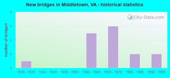
- New bridges - historical statistics
- 11930-1939
- 51960-1969
- 61970-1979
- 21980-1989
- 21990-1999


- Bridge Condition - Deck
- 12.5%Very good
- 37.5%Good
- 25.0%Satisfactory
- 25.0%Fair

- Bridge Condition - Superstructure
- 25.0%Good
- 50.0%Satisfactory
- 25.0%Fair

- Bridge Condition - Substructure
- 12.5%Very good
- 37.5%Good
- 37.5%Satisfactory
- 12.5%Fair

- Bridge Condition - Channel
- 57.1%Very good
- 14.3%Good
- 28.6%Fair

- Bridge Condition - Culverts
- 33.3%Very good
- 33.3%Good
- 33.3%Satisfactory
Find on map >> Show street view
Structure Number: 8109, Location: 0.21 TO 81-0.16 TO WARREN (Lat: 39.009911, Lng: -78.298347), Route carried "on" structure: Ramp Interstate 66, Year Built: 1964, Status: Open, Structure Length: 9.60m (31.50ft), Average Daily Traffic: 10,355 (year 2020), Truck Traffic: 15%, Average Future Daily Traffic: 12,991 (year 2040), Design Load: HS 20+Mod, Features Intersected: I-66 EBL RAMP & I-81 NBL
Minimum Vertical Clearance: 30+ m (98+ ft), Kilometerpoint: 0.338, Lanes on structure: 2, Lanes under structure: 2, Base Highway Network: Yes, Owner: State Highway Agency, Approaching Roadway Width: 13.4m (44.0ft), Skew: 9 degrees, Material/Design: Steel, Design/Construction: Stringer/Multi-beam, Number Of Spans In Main Unit: 3, Length of Maximum Span: 32.0m (105.0ft), Curb-To-Curb Width: 10.4m (34.1ft), Out-to-Out Width: 11.0m (36.1ft)
Condition: Deck: Satisfactory, Superstructure: Satisfactory, Substructure: Fair, Operating Rating: 63.5 metric tons, Method Used To Determine Operating Rating: Load and Resistance Factor (LRFR), Inventory Rating: 49.0 metric tons, Method Used To Determine Inventory Rating: Load and Resistance Factor (LRFR), Structural Evaluation: Somewhat better than minimum adequacy, Deck Geometry: Better than present minimum criteria, Underclear: Somewhat better than minimum adequacy, Approach Roadway Alignment: Equal to present minimum criteria, Length Of Structure Improvement: 9.60m (31.50ft), Designated Inspection Frequency: Every 24 months, Inspection Date: July 2021, Bridge Improvement Cost: $288,000, Roadway Improvement Cost: $31,000, Total Project Cost: $320,000, Deck Structure Type: Concrete Cast-file-Place, Wearing Surface/Protective System: Wearing Surface: Latex Concrete
Find on map >> Show street view
Structure Number: 8219, Location: 0.01 TO END - 0.10 TO 727 (Lat: 39.022517, Lng: -78.306797), Route carried "on" structure: County highway 624, Year Built: 1989, Status: Open, Structure Length: 0.70m (2.30ft), Average Daily Traffic: 182 (year 2014), Average Future Daily Traffic: 277 (year 2040), Design Load: HS 20+Mod, Features Intersected: MEADOW BROOK, Facility Carried by Structure: MEADOW MILLS RD
Minimum Vertical Clearance: 30+ m (98+ ft), Kilometerpoint: 0.161, Lanes on structure: 2, Owner: State Highway Agency, Approaching Roadway Width: 5.5m (18.0ft), Skew: 1 degrees, Material/Design: Concrete, Design/Construction: Slab, Number Of Spans In Main Unit: 1, Length of Maximum Span: 6.2m (20.3ft), Curb-To-Curb Width: 7.3m (24.0ft), Out-to-Out Width: 7.3m (24.0ft)
Condition: Deck: Good, Superstructure: Good, Substructure: Satisfactory, Channel: Fair, Operating Rating: 67.1 metric tons, Method Used To Determine Operating Rating: Load and Resistance Factor (LRFR), Inventory Rating: 51.7 metric tons, Method Used To Determine Inventory Rating: Load and Resistance Factor (LRFR), Structural Evaluation: Equal to present minimum criteria, Deck Geometry: Somewhat better than minimum adequacy, Waterway Adequacy: Meets minimum limits, Approach Roadway Alignment: Equal to present minimum criteria, Designated Inspection Frequency: Every 24 months, Inspection Date: June 2021, Deck Structure Type: Other, Wearing Surface/Protective System: Wearing Surface: Epoxy Overlay
Find on map >> Show street view
Structure Number: 822, Location: 0.50 TO 757 - 0.15 TO 727 (Lat: 39.024072, Lng: -78.302814), Route carried "on" structure: County highway 624, Year Built: 1987, Status: Open, Structure Length: 0.76m (2.49ft), Average Daily Traffic: 182 (year 2014), Average Future Daily Traffic: 277 (year 2040), Design Load: HS 20+Mod, Features Intersected: MEADOW BROOK, Facility Carried by Structure: MEADOW MILLS RD
Minimum Vertical Clearance: 30+ m (98+ ft), Kilometerpoint: 0.563, Lanes on structure: 2, Owner: State Highway Agency, Approaching Roadway Width: 5.5m (18.0ft), Skew: 3 degrees, Material/Design: Concrete, Design/Construction: Slab, Number Of Spans In Main Unit: 1, Length of Maximum Span: 6.0m (19.7ft), Curb-To-Curb Width: 7.5m (24.6ft), Out-to-Out Width: 8.6m (28.2ft)
Condition: Deck: Satisfactory, Superstructure: Satisfactory, Substructure: Good, Channel: Very good, Operating Rating: 89.8 metric tons, Method Used To Determine Operating Rating: Load and Resistance Factor (LRFR), Inventory Rating: 68.0 metric tons, Method Used To Determine Inventory Rating: Load and Resistance Factor (LRFR), Structural Evaluation: Equal to present minimum criteria, Deck Geometry: Somewhat better than minimum adequacy, Waterway Adequacy: Better than present minimum criteria, Approach Roadway Alignment: Equal to present desirable criteria, Designated Inspection Frequency: Every 24 months, Inspection Date: August 2021, Deck Structure Type: Other, Wearing Surface/Protective System: Wearing Surface: Epoxy Overlay
Find on map >> Show street view
Structure Number: 8223, Location: 0.05 TO 842 - 0.41 TO 11 (Lat: 39.027494, Lng: -78.269711), Route carried "on" structure: County highway 627, Year Built: 1965, Status: Open, Structure Length: 7.83m (25.69ft), Average Daily Traffic: 1,969 (year 2020), Truck Traffic: 3%, Average Future Daily Traffic: 2,166 (year 2040), Design Load: HS 20+Mod, Features Intersected: I-81, Facility Carried by Structure: RELIANCE RD
Minimum Vertical Clearance: 30+ m (98+ ft), Kilometerpoint: 2.204, Lanes on structure: 2, Lanes under structure: 4, Owner: State Highway Agency, Approaching Roadway Width: 7.6m (24.9ft), Skew: 1 degrees, Material/Design: Prestressed concrete, Design/Construction: Box Beam or Girders - Multiple, Number Of Spans In Main Unit: 4, Length of Maximum Span: 23.2m (76.1ft), Curb or Sidewalk Widths: Left: 0.5m (1.6ft), Right: 0.5m (1.6ft), Curb-To-Curb Width: 9.1m (29.9ft), Out-to-Out Width: 10.7m (35.1ft)
Condition: Deck: Fair, Superstructure: Satisfactory, Substructure: Satisfactory, Operating Rating: 88.9 metric tons, Method Used To Determine Operating Rating: Load and Resistance Factor (LRFR), Inventory Rating: 60.8 metric tons, Method Used To Determine Inventory Rating: Load and Resistance Factor (LRFR), Structural Evaluation: Equal to present minimum criteria, Deck Geometry: Somewhat better than minimum adequacy, Underclear: Equal to present minimum criteria, Approach Roadway Alignment: Better than present minimum criteria, Length Of Structure Improvement: 7.83m (25.69ft), Designated Inspection Frequency: Every 24 months, Inspection Date: October 2020, Bridge Improvement Cost: $102,000, Roadway Improvement Cost: $20,000, Total Project Cost: $123,000, Deck Structure Type: Concrete Cast-file-Place, Wearing Surface/Protective System: Wearing Surface: Latex Concrete
Find on map >> Show street view
Structure Number: 18709, Location: 1.75 FRED CO- 4.77 TO 340 (Lat: 38.997131, Lng: -78.267622), Route carried "on" structure: Interstate 66, Year Built: 1970, Status: Open, Structure Length: 0.73m (2.40ft), Average Daily Traffic: 30,563 (year 2020), Truck Traffic: 15%, Average Future Daily Traffic: 42,788 (year 2040), Design Load: HS 20, Features Intersected: MOLLY BOOTH RUN
Minimum Vertical Clearance: 30+ m (98+ ft), Kilometerpoint: 3.170, Lanes on structure: 4, Base Highway Network: Yes, Owner: State Highway Agency, Approaching Roadway Width: 26.8m (87.9ft), Skew: 1 degrees, Material/Design: Concrete, Design/Construction: Culvert, Number Of Spans In Main Unit: 3, Length of Maximum Span: 2.1m (6.9ft)
Condition: Channel: Fair, Culverts: Satisfactory, Operating Rating: 89.8 metric tons, Method Used To Determine Operating Rating: Field evaluation and documented engineering judgment, Inventory Rating: 88.9 metric tons, Method Used To Determine Inventory Rating: Field evaluation and documented engineering judgment, Structural Evaluation: Equal to present minimum criteria, Waterway Adequacy: Equal to present minimum criteria, Approach Roadway Alignment: Equal to present desirable criteria, Designated Inspection Frequency: Every 24 months, Inspection Date: March 2021, Bridge Improvement Cost: $15,000, Total Project Cost: $17,000
Find on map >> Show street view
Structure Number: 18774, Location: 1.15 TO 616 - 0.96 TO 626 (Lat: 38.975481, Lng: -78.267975), Route carried "on" structure: County highway 610, Year Built: 1932, Status: Open, Structure Length: 1.49m (4.89ft), Average Daily Traffic: 43 (year 2017), Average Future Daily Traffic: 63 (year 2040), Features Intersected: PASSAGE CREEK, Facility Carried by Structure: BUCKS MILL RD
Minimum Vertical Clearance: 30+ m (98+ ft), Kilometerpoint: 2.172, Lanes on structure: 1, Owner: State Highway Agency, Approaching Roadway Width: 3.0m (9.8ft), Material/Design: Concrete, Design/Construction: Slab, Number Of Spans In Main Unit: 2, Length of Maximum Span: 7.0m (23.0ft), Curb or Sidewalk Widths: Left: 0.3m (1.0ft), Right: 0.3m (1.0ft), Curb-To-Curb Width: 3.3m (10.8ft), Out-to-Out Width: 3.9m (12.8ft)
Condition: Deck: Fair, Superstructure: Fair, Substructure: Satisfactory, Channel: Very good, Operating Rating: 40.8 metric tons, Method Used To Determine Operating Rating: Field evaluation and documented engineering judgment, Inventory Rating: 24.5 metric tons, Method Used To Determine Inventory Rating: Field evaluation and documented engineering judgment, Structural Evaluation: Somewhat better than minimum adequacy, Deck Geometry: High priority of replacement, Waterway Adequacy: High priority of corrective action, Approach Roadway Alignment: Equal to present minimum criteria, Length Of Structure Improvement: 1.49m (4.89ft), Designated Inspection Frequency: Every 24 months, Inspection Date: May 2021, Bridge Improvement Cost: $80,000, Roadway Improvement Cost: $20,000, Total Project Cost: $101,000, Deck Structure Type: Concrete Cast-file-Place, Wearing Surface/Protective System: Wearing Surface: Bituminous
Find on map >> Show street view
Structure Number: 18775, Location: 1.05 TO 637 - 0.25 TO 842 (Lat: 38.994869, Lng: -78.268458), Route carried "on" structure: County highway 611, Year Built: 1976, Status: Open, Structure Length: 1.55m (5.09ft), Average Daily Traffic: 272 (year 2014), Average Future Daily Traffic: 413 (year 2040), Design Load: HS 20+Mod, Features Intersected: MOLLY BOOTH RUN, Facility Carried by Structure: LONG MEADOW RD
Minimum Vertical Clearance: 30+ m (98+ ft), Kilometerpoint: 8.159, Lanes on structure: 2, Owner: State Highway Agency, Approaching Roadway Width: 5.2m (17.1ft), Skew: 1 degrees, Material/Design: Steel, Design/Construction: Stringer/Multi-beam, Number Of Spans In Main Unit: 1, Length of Maximum Span: 14.6m (47.9ft), Curb or Sidewalk Widths: Left: 0.2m (0.7ft), Right: 0.2m (0.7ft), Curb-To-Curb Width: 7.0m (23.0ft), Out-to-Out Width: 7.3m (24.0ft)
Condition: Deck: Good, Superstructure: Fair, Substructure: Good, Channel: Very good, Operating Rating: 46.4 metric tons, Method Used To Determine Operating Rating: Load Factor (LF), Inventory Rating: 27.8 metric tons, Method Used To Determine Inventory Rating: Load Factor (LF), Structural Evaluation: Somewhat better than minimum adequacy, Deck Geometry: Meets minimum limits, Waterway Adequacy: Somewhat better than minimum adequacy, Approach Roadway Alignment: Equal to present minimum criteria, Designated Inspection Frequency: Every 24 months, Inspection Date: March 2021, Deck Structure Type: Wood or Timber, Wearing Surface/Protective System: Wearing Surface: Bituminous
Find on map >> Show street view
Structure Number: 18804, Location: 0.02 TO 611 - 2.95 TO 627 (Lat: 38.992789, Lng: -78.250303), Route carried "on" structure: County highway 637, Year Built: 1971, Status: Open, Structure Length: 7.68m (25.20ft), Average Daily Traffic: 575 (year 2020), Truck Traffic: 3%, Average Future Daily Traffic: 597 (year 2040), Design Load: HS 20+Mod, Features Intersected: I-66, Facility Carried by Structure: NORTH RIVER RD
Minimum Vertical Clearance: 30+ m (98+ ft), Kilometerpoint: 7.503, Lanes on structure: 2, Lanes under structure: 4, Owner: State Highway Agency, Approaching Roadway Width: 5.8m (19.0ft), Material/Design: Steel continuous, Design/Construction: Stringer/Multi-beam, Number Of Spans In Main Unit: 2, Length of Maximum Span: 38.4m (126.0ft), Curb or Sidewalk Widths: Left: 0.2m (0.7ft), Right: 0.2m (0.7ft), Curb-To-Curb Width: 8.7m (28.5ft), Out-to-Out Width: 9.4m (30.8ft)
Condition: Deck: Very good, Superstructure: Good, Substructure: Very good, Operating Rating: 71.7 metric tons, Method Used To Determine Operating Rating: Load and Resistance Factor (LRFR), Inventory Rating: 55.3 metric tons, Method Used To Determine Inventory Rating: Load and Resistance Factor (LRFR), Structural Evaluation: Better than present minimum criteria, Deck Geometry: Somewhat better than minimum adequacy, Underclear: Equal to present minimum criteria, Approach Roadway Alignment: Better than present minimum criteria, Designated Inspection Frequency: Every 24 months, Inspection Date: November 2020, Deck Structure Type: Concrete Cast-file-Place, Wearing Surface/Protective System: Wearing Surface: Epoxy Overlay
Find on map >> Show street view
Structure Number: 18831, Location: 0.11 TO 611-0.95FREDERICK (Lat: 38.998028, Lng: -78.272178), Route carried "on" structure: County highway 842, Year Built: 1971, Status: Open, Structure Length: 7.62m (25.00ft), Average Daily Traffic: 142 (year 2020), Average Future Daily Traffic: 156 (year 2040), Design Load: HS 20+Mod, Features Intersected: I-66, Facility Carried by Structure: SULPHUR SPRINGS RD
Minimum Vertical Clearance: 30+ m (98+ ft), Kilometerpoint: 2.981, Lanes on structure: 2, Lanes under structure: 4, Owner: State Highway Agency, Approaching Roadway Width: 5.5m (18.0ft), Material/Design: Steel continuous, Design/Construction: Stringer/Multi-beam, Number Of Spans In Main Unit: 2, Length of Maximum Span: 38.1m (125.0ft), Curb or Sidewalk Widths: Left: 0.2m (0.7ft), Right: 0.2m (0.7ft), Curb-To-Curb Width: 8.1m (26.6ft), Out-to-Out Width: 9.3m (30.5ft)
Condition: Deck: Good, Superstructure: Satisfactory, Substructure: Good, Operating Rating: 75.3 metric tons, Method Used To Determine Operating Rating: Load and Resistance Factor (LRFR), Inventory Rating: 58.1 metric tons, Method Used To Determine Inventory Rating: Load and Resistance Factor (LRFR), Structural Evaluation: Equal to present minimum criteria, Deck Geometry: Somewhat better than minimum adequacy, Underclear: Equal to present minimum criteria, Approach Roadway Alignment: Equal to present desirable criteria, Designated Inspection Frequency: Every 24 months, Inspection Date: November 2020, Deck Structure Type: Concrete Cast-file-Place, Wearing Surface/Protective System: Wearing Surface: Epoxy Overlay
Find on map >> Show street view
Structure Number: 23554, Location: 0.14 TO 1101-0.08 WCL MID (Lat: 39.032886, Lng: -78.279892), Route carried "on" structure: County highway 627, Year Built: 1992, Status: Open, Structure Length: 0.79m (2.59ft), Average Daily Traffic: 1,217 (year 2020), Truck Traffic: 4%, Average Future Daily Traffic: 1,339 (year 2040), Design Load: HS 20, Features Intersected: MEADOW BROOK @MIDDLETOWN, Facility Carried by Structure: FIRST STREET
Minimum Vertical Clearance: 30+ m (98+ ft), Kilometerpoint: 3.878, Lanes on structure: 2, Owner: State Highway Agency, Approaching Roadway Width: 4.9m (16.1ft), Material/Design: Concrete, Design/Construction: Culvert, Number Of Spans In Main Unit: 2, Length of Maximum Span: 3.7m (12.1ft)
Condition: Channel: Good, Culverts: Good, Operating Rating: 44.5 metric tons, Method Used To Determine Operating Rating: Field evaluation and documented engineering judgment, Inventory Rating: 32.7 metric tons, Method Used To Determine Inventory Rating: Field evaluation and documented engineering judgment, Structural Evaluation: Better than present minimum criteria, Waterway Adequacy: Equal to present minimum criteria, Approach Roadway Alignment: Better than present minimum criteria, Designated Inspection Frequency: Every 24 months, Inspection Date: October 2021
Find on map >> Show street view
Structure Number: 23939, Location: 0.65 TO 11 - 0.87 TO 625 (Lat: 39.052986, Lng: -78.262936), Route carried "on" structure: County highway 633, Year Built: 1994, Status: Open, Structure Length: 0.79m (2.59ft), Average Daily Traffic: 369 (year 2014), Average Future Daily Traffic: 561 (year 2040), Design Load: HS 20+Mod, Features Intersected: MEADOW BROOK, Facility Carried by Structure: KLINES MILL RD
Minimum Vertical Clearance: 30+ m (98+ ft), Kilometerpoint: 1.207, Lanes on structure: 2, Owner: State Highway Agency, Approaching Roadway Width: 6.1m (20.0ft), Material/Design: Concrete, Design/Construction: Culvert, Number Of Spans In Main Unit: 2, Length of Maximum Span: 3.7m (12.1ft)
Condition: Channel: Very good, Culverts: Very good, Operating Rating: 54.4 metric tons, Method Used To Determine Operating Rating: Field evaluation and documented engineering judgment, Inventory Rating: 32.7 metric tons, Method Used To Determine Inventory Rating: Field evaluation and documented engineering judgment, Structural Evaluation: Equal to present desirable criteria, Waterway Adequacy: Equal to present minimum criteria, Approach Roadway Alignment: Equal to present desirable criteria, Designated Inspection Frequency: Every 24 months, Inspection Date: October 2020
Find on map >> Show street view
Structure Number: 8109, Location: 0.21 TO 81-0.16 TO WARREN (Lat: 39.009911, Lng: -78.298347), Route carried "under" structure: Ramp Interstate 66, Year Built: 1964, Structure Length: 0. m, Average Daily Traffic: 10,691 (year 1994), Features Intersected: I-66 EBL RAMP & I-81 NBL
Minimum Vertical Clearance: 5.61m (18.41ft), Kilometerpoint: 0.000, Lanes on structure: 2, Lanes under structure: 2, Material/Design: Steel, Design/Construction: Stringer/Multi-beam, Length of Maximum Span: 32.0m (105.0ft)
Find on map >> Show street view
Structure Number: 8111, Location: 0.18 WARREN CO-0.21 81SBL (Lat: 39.010067, Lng: -78.297831), Route carried "under" structure: Interstate 66, Year Built: 1964, Structure Length: 0. m, Average Daily Traffic: 43,437 (year 2008), Truck Traffic: 10%, Features Intersected: I-81 NBL
Minimum Vertical Clearance: 5.03m (16.50ft), Kilometerpoint: 484.534, Lanes on structure: 2, Lanes under structure: 2, Material/Design: Steel, Design/Construction: Stringer/Multi-beam, Length of Maximum Span: 20.7m (67.9ft)
Find on map >> Show street view
Structure Number: 8223, Location: 0.05 TO 842 - 0.41 TO 11 (Lat: 39.027494, Lng: -78.269711), Route carried "under" structure: Interstate 81, Year Built: 1965, Structure Length: 0. m, Average Daily Traffic: 45,804 (year 2008), Truck Traffic: 10%, Features Intersected: I-81, Facility Carried by Structure: RELIANCE RD
Minimum Vertical Clearance: 5.41m (17.75ft), Kilometerpoint: 487.672, Lanes on structure: 2, Lanes under structure: 4, Material/Design: Prestressed concrete, Design/Construction: Box Beam or Girders - Multiple, Length of Maximum Span: 23.2m (76.1ft)
Find on map >> Show street view
Structure Number: 18804, Location: 0.02 TO 611 - 2.95 TO 627 (Lat: 38.992789, Lng: -78.250303), Route carried "under" structure: Interstate 66, Year Built: 1971, Structure Length: 0. m, Average Daily Traffic: 28,144 (year 2008), Truck Traffic: 9%, Features Intersected: I-66, Facility Carried by Structure: NORTH RIVER RD
Minimum Vertical Clearance: 5.28m (17.32ft), Kilometerpoint: 4.747, Lanes on structure: 2, Lanes under structure: 4, Material/Design: Steel continuous, Design/Construction: Stringer/Multi-beam, Length of Maximum Span: 38.4m (126.0ft)
Find on map >> Show street view
Structure Number: 18831, Location: 0.11 TO 611-0.95FREDERICK (Lat: 38.998028, Lng: -78.272178), Route carried "under" structure: Interstate 66, Year Built: 1971, Structure Length: 0. m, Average Daily Traffic: 28,144 (year 2008), Truck Traffic: 9%, Features Intersected: I-66, Facility Carried by Structure: SULPHUR SPRINGS RD
Minimum Vertical Clearance: 6.48m (21.26ft), Kilometerpoint: 2.751, Lanes on structure: 2, Lanes under structure: 4, Material/Design: Steel continuous, Design/Construction: Stringer/Multi-beam, Length of Maximum Span: 38.1m (125.0ft)