Bridge Statistics for Middleburg Heights, Ohio (OH)
Condition, Traffic, Stress, Structural Evaluation, Project Costs
- National Bridge Inventory (NBI) Statistics
- 28Number of bridges
- 220ft / 67.3mTotal length
- $122,000Total costs
- 877,683Total average daily traffic
- 27,962Total average daily truck traffic
- National Bridge Inventory (NBI) Registered Bridges for Middleburg Heights
- No street view available for this location
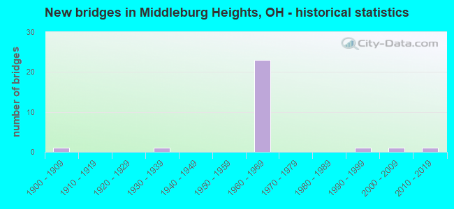
- New bridges - historical statistics
- 11900-1909
- 11930-1939
- 231960-1969
- 11990-1999
- 12000-2009
- 12010-2019
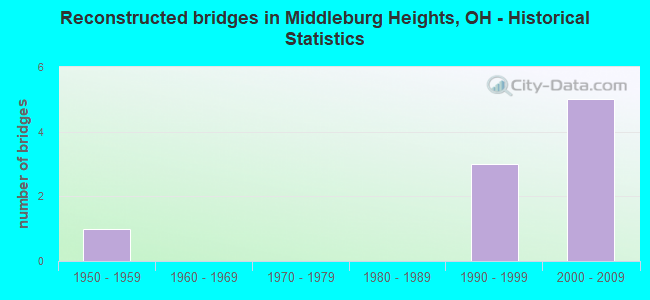
- Reconstructed bridges - Historical Statistics
- 11950-1959
- 01960-1969
- 01970-1979
- 01980-1989
- 31990-1999
- 52000-2009
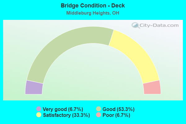
- Bridge Condition - Deck
- 6.7%Very good
- 53.3%Good
- 33.3%Satisfactory
- 6.7%Poor
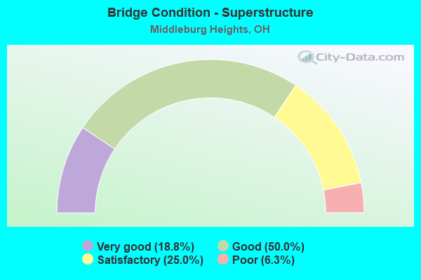
- Bridge Condition - Superstructure
- 18.8%Very good
- 50.0%Good
- 25.0%Satisfactory
- 6.3%Poor
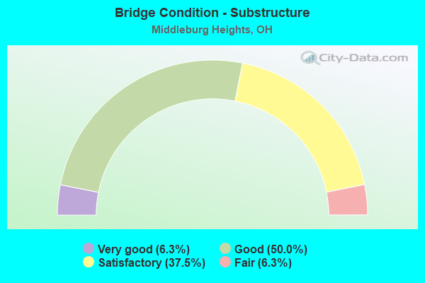
- Bridge Condition - Substructure
- 6.3%Very good
- 50.0%Good
- 37.5%Satisfactory
- 6.3%Fair
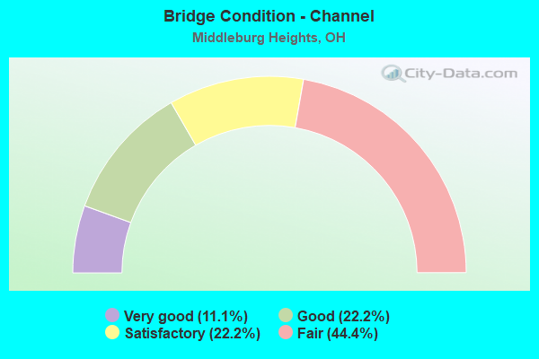
- Bridge Condition - Channel
- 11.1%Very good
- 22.2%Good
- 22.2%Satisfactory
- 44.4%Fair

- Bridge Condition - Culverts
- 33.3%Very good
- 33.3%Good
- 33.3%Fair
Find on map >> Show street view
Structure Number: 1803905, Location: .32 MI. S. OF JCT. US-42 (Lat: 41.350889, Lng: -81.818239), Route carried "on" structure: Interstate 71, Year Built: 1966, Year Reconstructed: 2000, Status: Open, Structure Length: 4.79m (15.72ft), Average Daily Traffic: 46,979 (year 2015), Truck Traffic: 3%, Average Future Daily Traffic: 65,207 (year 2035), Design Load: HS 20+Mod, Features Intersected: CR 67 (SPRAGUE RD)
Minimum Vertical Clearance: 30+ m (98+ ft), Kilometerpoint: 8.385, Lanes on structure: 3, Lanes under structure: 2, Base Highway Network: Yes, Owner: State Highway Agency, Approaching Roadway Width: 18.3m (60.0ft), Material/Design: Steel continuous, Design/Construction: Stringer/Multi-beam, Number Of Spans In Main Unit: 3, Length of Maximum Span: 19.5m (64.0ft), Curb-To-Curb Width: 19.5m (64.0ft), Out-to-Out Width: 20.4m (66.9ft)
Condition: Deck: Satisfactory, Superstructure: Very good, Substructure: Good, Operating Rating: 42.1 metric tons, Method Used To Determine Operating Rating: Allowable Stress (AS) rating reported by rating factor (RF) method using MS18 loading, Inventory Rating: 32.4 metric tons, Method Used To Determine Inventory Rating: Allowable Stress (AS) rating reported by rating factor (RF) method using MS18 loading, Structural Evaluation: Better than present minimum criteria, Deck Geometry: Superior to present desirable criteria, Underclear: Equal to present minimum criteria, Approach Roadway Alignment: Equal to present desirable criteria, Designated Inspection Frequency: Every 12 months, Inspection Date: April 2021, Deck Structure Type: Concrete Cast-file-Place, Wearing Surface/Protective System: Wearing Surface: Monolithic Concrete, Deck Protection: Epoxy Coated Reinforcing
Find on map >> Show street view
Structure Number: 1803964, Location: .32 MI. S. OF JCT. US-42 (Lat: 41.350869, Lng: -81.817811), Route carried "on" structure: Interstate 71, Year Built: 1966, Year Reconstructed: 2000, Status: Open, Structure Length: 4.79m (15.72ft), Average Daily Traffic: 46,979 (year 2015), Truck Traffic: 3%, Average Future Daily Traffic: 65,207 (year 2035), Design Load: HS 20+Mod, Features Intersected: CR 67 (SPRAGUE RD)
Minimum Vertical Clearance: 30+ m (98+ ft), Kilometerpoint: 8.385, Lanes on structure: 3, Lanes under structure: 2, Base Highway Network: Yes, Owner: State Highway Agency, Approaching Roadway Width: 18.3m (60.0ft), Material/Design: Steel continuous, Design/Construction: Stringer/Multi-beam, Number Of Spans In Main Unit: 3, Length of Maximum Span: 19.5m (64.0ft), Curb-To-Curb Width: 19.5m (64.0ft), Out-to-Out Width: 20.4m (66.9ft)
Condition: Deck: Satisfactory, Superstructure: Very good, Substructure: Good, Operating Rating: 42.1 metric tons, Method Used To Determine Operating Rating: Allowable Stress (AS) rating reported by rating factor (RF) method using MS18 loading, Inventory Rating: 32.4 metric tons, Method Used To Determine Inventory Rating: Allowable Stress (AS) rating reported by rating factor (RF) method using MS18 loading, Structural Evaluation: Better than present minimum criteria, Deck Geometry: Superior to present desirable criteria, Underclear: Equal to present minimum criteria, Approach Roadway Alignment: Equal to present desirable criteria, Designated Inspection Frequency: Every 12 months, Inspection Date: April 2021, Deck Structure Type: Concrete Cast-file-Place, Wearing Surface/Protective System: Wearing Surface: Monolithic Concrete, Deck Protection: Epoxy Coated Reinforcing
Find on map >> Show street view
Structure Number: 1803999, Location: .15 MI.S. OF JCT. US-42 (Lat: 41.353350, Lng: -81.818561), Route carried "on" structure: Interstate 71, Year Built: 1966, Status: Open, Structure Length: 1.07m (3.51ft), Average Daily Traffic: 81,678 (year 2015), Truck Traffic: 3%, Average Future Daily Traffic: 113,369 (year 2035), Design Load: H 20, Features Intersected: BALDWIN CREEK
Minimum Vertical Clearance: 30+ m (98+ ft), Kilometerpoint: 8.658, Lanes on structure: 4, Base Highway Network: Yes, Owner: State Highway Agency, Approaching Roadway Width: 46.3m (151.9ft), Skew: 23 degrees, Material/Design: Concrete, Design/Construction: Culvert, Number Of Spans In Main Unit: 2, Length of Maximum Span: 5.2m (17.1ft)
Condition: Channel: Fair, Culverts: Good, Operating Rating: 42.1 metric tons, Method Used To Determine Operating Rating: Load Factor (LF) rating reported by rating factor (RF) method using MS18 loading, Inventory Rating: 32.4 metric tons, Method Used To Determine Inventory Rating: Load Factor (LF) rating reported by rating factor (RF) method using MS18 loading, Structural Evaluation: Better than present minimum criteria, Waterway Adequacy: Equal to present desirable criteria, Approach Roadway Alignment: Equal to present desirable criteria, Designated Inspection Frequency: Every 24 months, Inspection Date: October 2021
Find on map >> Show street view
Structure Number: 1804022, Location: JCT. US-42 AND I-71 (Lat: 41.355239, Lng: -81.819261), Route carried "on" structure: Interstate 71, Year Built: 1966, Year Reconstructed: 2000, Status: Open, Structure Length: 7.47m (24.51ft), Average Daily Traffic: 40,839 (year 2015), Truck Traffic: 3%, Average Future Daily Traffic: 56,685 (year 2035), Design Load: HS 20+Mod, Features Intersected: (42-0577) PEARL ROAD
Minimum Vertical Clearance: 30+ m (98+ ft), Kilometerpoint: 8.900, Lanes on structure: 3, Lanes under structure: 4, Base Highway Network: Yes, Owner: State Highway Agency, Approaching Roadway Width: 18.3m (60.0ft), Skew: 5 degrees, Material/Design: Steel continuous, Design/Construction: Stringer/Multi-beam, Number Of Spans In Main Unit: 4, Length of Maximum Span: 21.3m (69.9ft), Curb-To-Curb Width: 26.6m (87.3ft), Out-to-Out Width: 27.5m (90.2ft)
Condition: Deck: Satisfactory, Superstructure: Good, Substructure: Satisfactory, Operating Rating: 42.1 metric tons, Method Used To Determine Operating Rating: Allowable Stress (AS) rating reported by rating factor (RF) method using MS18 loading, Inventory Rating: 32.4 metric tons, Method Used To Determine Inventory Rating: Allowable Stress (AS) rating reported by rating factor (RF) method using MS18 loading, Structural Evaluation: Equal to present minimum criteria, Deck Geometry: Superior to present desirable criteria, Underclear: Meets minimum limits, Approach Roadway Alignment: Equal to present desirable criteria, Designated Inspection Frequency: Every 12 months, Inspection Date: April 2021, Deck Structure Type: Concrete Cast-file-Place, Wearing Surface/Protective System: Wearing Surface: Monolithic Concrete, Deck Protection: Epoxy Coated Reinforcing
Find on map >> Show street view
Structure Number: 1804057, Location: JCT. US-42 AND I-71 (Lat: 41.355781, Lng: -81.819031), Route carried "on" structure: Interstate 71, Year Built: 1966, Year Reconstructed: 2000, Status: Open, Structure Length: 7.47m (24.51ft), Average Daily Traffic: 52,752 (year 2015), Truck Traffic: 3%, Average Future Daily Traffic: 73,220 (year 2035), Design Load: HS 20+Mod, Features Intersected: (42-0580)PEARL ROAD
Minimum Vertical Clearance: 30+ m (98+ ft), Kilometerpoint: 8.900, Lanes on structure: 3, Lanes under structure: 4, Base Highway Network: Yes, Owner: State Highway Agency, Approaching Roadway Width: 18.3m (60.0ft), Skew: 5 degrees, Material/Design: Steel continuous, Design/Construction: Stringer/Multi-beam, Number Of Spans In Main Unit: 4, Length of Maximum Span: 21.3m (69.9ft), Curb-To-Curb Width: 26.6m (87.3ft), Out-to-Out Width: 29.4m (96.5ft)
Condition: Deck: Satisfactory, Superstructure: Good, Substructure: Satisfactory, Operating Rating: 42.1 metric tons, Method Used To Determine Operating Rating: Allowable Stress (AS) rating reported by rating factor (RF) method using MS18 loading, Inventory Rating: 32.4 metric tons, Method Used To Determine Inventory Rating: Allowable Stress (AS) rating reported by rating factor (RF) method using MS18 loading, Structural Evaluation: Equal to present minimum criteria, Deck Geometry: Superior to present desirable criteria, Underclear: Meets minimum limits, Approach Roadway Alignment: Equal to present desirable criteria, Designated Inspection Frequency: Every 12 months, Inspection Date: April 2021, Deck Structure Type: Concrete Cast-file-Place, Wearing Surface/Protective System: Wearing Surface: Monolithic Concrete, Deck Protection: Epoxy Coated Reinforcing
Find on map >> Show street view
Structure Number: 1804081, Location: .26 MI. N. OF JCT. US-42 (Lat: 41.359231, Lng: -81.820331), Route carried "on" structure: Interstate 71, Year Built: 1966, Status: Open, Structure Length: 4.88m (16.01ft), Average Daily Traffic: 52,752 (year 2015), Truck Traffic: 3%, Average Future Daily Traffic: 73,220 (year 2035), Design Load: HS 20+Mod, Features Intersected: CR 299 (FOWLES RD)
Minimum Vertical Clearance: 30+ m (98+ ft), Kilometerpoint: 9.318, Lanes on structure: 3, Lanes under structure: 2, Base Highway Network: Yes, Owner: State Highway Agency, Approaching Roadway Width: 21.9m (71.9ft), Skew: 1 degrees, Material/Design: Steel continuous, Design/Construction: Stringer/Multi-beam, Number Of Spans In Main Unit: 3, Length of Maximum Span: 19.8m (65.0ft), Curb-To-Curb Width: 21.9m (71.9ft), Out-to-Out Width: 22.9m (75.1ft)
Condition: Deck: Good, Superstructure: Satisfactory, Substructure: Fair, Operating Rating: 42.1 metric tons, Method Used To Determine Operating Rating: Allowable Stress (AS) rating reported by rating factor (RF) method using MS18 loading, Inventory Rating: 32.4 metric tons, Method Used To Determine Inventory Rating: Allowable Stress (AS) rating reported by rating factor (RF) method using MS18 loading, Structural Evaluation: Somewhat better than minimum adequacy, Deck Geometry: Superior to present desirable criteria, Underclear: Meets minimum limits, Approach Roadway Alignment: Equal to present desirable criteria, Designated Inspection Frequency: Every 12 months, Inspection Date: Febuary 2021, Deck Structure Type: Concrete Cast-file-Place, Wearing Surface/Protective System: Wearing Surface: Monolithic Concrete
Find on map >> Show street view
Structure Number: 1804111, Location: .26 MI N. OF JCT. US-42 (Lat: 41.359219, Lng: -81.819961), Route carried "on" structure: Interstate 71, Year Built: 1966, Status: Open, Structure Length: 4.88m (16.01ft), Average Daily Traffic: 52,752 (year 2015), Truck Traffic: 3%, Average Future Daily Traffic: 73,220 (year 2035), Design Load: HS 20+Mod, Features Intersected: CR 299 (FOWLES RD)
Minimum Vertical Clearance: 30+ m (98+ ft), Kilometerpoint: 9.318, Lanes on structure: 3, Lanes under structure: 2, Base Highway Network: Yes, Owner: State Highway Agency, Approaching Roadway Width: 20.1m (65.9ft), Skew: 1 degrees, Material/Design: Steel continuous, Design/Construction: Stringer/Multi-beam, Number Of Spans In Main Unit: 3, Length of Maximum Span: 19.8m (65.0ft), Curb-To-Curb Width: 20.1m (65.9ft), Out-to-Out Width: 21.0m (68.9ft)
Condition: Deck: Good, Superstructure: Good, Substructure: Good, Operating Rating: 42.1 metric tons, Method Used To Determine Operating Rating: Allowable Stress (AS) rating reported by rating factor (RF) method using MS18 loading, Inventory Rating: 32.4 metric tons, Method Used To Determine Inventory Rating: Allowable Stress (AS) rating reported by rating factor (RF) method using MS18 loading, Structural Evaluation: Better than present minimum criteria, Deck Geometry: Superior to present desirable criteria, Underclear: Equal to present minimum criteria, Approach Roadway Alignment: Equal to present desirable criteria, Designated Inspection Frequency: Every 24 months, Inspection Date: Febuary 2021, Deck Structure Type: Concrete Cast-file-Place, Wearing Surface/Protective System: Wearing Surface: Monolithic Concrete
Find on map >> Show street view
Structure Number: 1804146, Location: .49 MI. N. OF JCT. US-42 (Lat: 41.362411, Lng: -81.821200), Route carried "on" structure: Interstate 71, Year Built: 1966, Year Reconstructed: 1998, Status: Open, Structure Length: 4.94m (16.21ft), Average Daily Traffic: 52,752 (year 2015), Truck Traffic: 3%, Average Future Daily Traffic: 73,220 (year 2035), Design Load: HS 20+Mod, Features Intersected: BIG CREEK PKWY
Minimum Vertical Clearance: 30+ m (98+ ft), Kilometerpoint: 9.688, Lanes on structure: 3, Lanes under structure: 4, Base Highway Network: Yes, Owner: State Highway Agency, Approaching Roadway Width: 15.9m (52.2ft), Skew: 2 degrees, Material/Design: Steel continuous, Design/Construction: Stringer/Multi-beam, Number Of Spans In Main Unit: 4, Length of Maximum Span: 13.4m (44.0ft), Curb-To-Curb Width: 15.2m (49.9ft), Out-to-Out Width: 16.5m (54.1ft)
Condition: Deck: Good, Superstructure: Good, Substructure: Good, Operating Rating: 42.1 metric tons, Method Used To Determine Operating Rating: Allowable Stress (AS) rating reported by rating factor (RF) method using MS18 loading, Inventory Rating: 32.4 metric tons, Method Used To Determine Inventory Rating: Allowable Stress (AS) rating reported by rating factor (RF) method using MS18 loading, Structural Evaluation: Better than present minimum criteria, Deck Geometry: Meets minimum limits, Underclear: Meets minimum limits, Approach Roadway Alignment: Equal to present desirable criteria, Designated Inspection Frequency: Every 24 months, Inspection Date: August 2021, Deck Structure Type: Concrete Cast-file-Place, Wearing Surface/Protective System: Wearing Surface: Monolithic Concrete
Find on map >> Show street view
Structure Number: 180417, Location: .49 MI. N. OF JCT. US-42 (Lat: 41.362581, Lng: -81.820831), Route carried "on" structure: Interstate 71, Year Built: 1966, Status: Open, Structure Length: 4.94m (16.21ft), Average Daily Traffic: 52,752 (year 2015), Truck Traffic: 3%, Average Future Daily Traffic: 73,220 (year 2035), Design Load: HS 20+Mod, Features Intersected: BIG CREEK PKWY
Minimum Vertical Clearance: 30+ m (98+ ft), Kilometerpoint: 9.688, Lanes on structure: 3, Lanes under structure: 4, Base Highway Network: Yes, Owner: State Highway Agency, Approaching Roadway Width: 15.2m (49.9ft), Skew: 2 degrees, Material/Design: Steel continuous, Design/Construction: Stringer/Multi-beam, Number Of Spans In Main Unit: 4, Length of Maximum Span: 13.4m (44.0ft), Curb-To-Curb Width: 15.9m (52.2ft), Out-to-Out Width: 16.5m (54.1ft)
Condition: Deck: Very good, Superstructure: Good, Substructure: Good, Operating Rating: 42.1 metric tons, Method Used To Determine Operating Rating: Allowable Stress (AS) rating reported by rating factor (RF) method using MS18 loading, Inventory Rating: 32.4 metric tons, Method Used To Determine Inventory Rating: Allowable Stress (AS) rating reported by rating factor (RF) method using MS18 loading, Structural Evaluation: Better than present minimum criteria, Deck Geometry: Somewhat better than minimum adequacy, Underclear: Meets minimum limits, Approach Roadway Alignment: Equal to present desirable criteria, Designated Inspection Frequency: Every 24 months, Inspection Date: August 2021, Deck Structure Type: Concrete Cast-file-Place, Wearing Surface/Protective System: Wearing Surface: Monolithic Concrete
Find on map >> Show street view
Structure Number: 18042, Location: .84 MI. N. OF JCT. US-42 (Lat: 41.367350, Lng: -81.821619), Route carried "on" structure: Interstate 71, Year Built: 1966, Year Reconstructed: 1999, Status: Open, Structure Length: 7.89m (25.89ft), Average Daily Traffic: 105,503 (year 2015), Truck Traffic: 3%, Average Future Daily Traffic: 146,438 (year 2035), Design Load: HS 20+Mod, Features Intersected: CSX RR
Minimum Vertical Clearance: 30+ m (98+ ft), Kilometerpoint: 10.252, Lanes on structure: 6, Base Highway Network: Yes, Owner: State Highway Agency, Approaching Roadway Width: 40.8m (133.9ft), Skew: 15 degrees, Material/Design: Steel continuous, Design/Construction: Stringer/Multi-beam, Number Of Spans In Main Unit: 3, Length of Maximum Span: 29.3m (96.1ft), Curb-To-Curb Width: 40.2m (131.9ft), Out-to-Out Width: 41.5m (136.2ft)
Condition: Deck: Good, Superstructure: Good, Substructure: Good, Operating Rating: 42.1 metric tons, Method Used To Determine Operating Rating: Allowable Stress (AS) rating reported by rating factor (RF) method using MS18 loading, Inventory Rating: 32.4 metric tons, Method Used To Determine Inventory Rating: Allowable Stress (AS) rating reported by rating factor (RF) method using MS18 loading, Structural Evaluation: Better than present minimum criteria, Deck Geometry: Superior to present desirable criteria, Underclear: Better than present minimum criteria, Approach Roadway Alignment: Equal to present desirable criteria, Designated Inspection Frequency: Every 24 months, Inspection Date: December 2021, Deck Structure Type: Concrete Cast-file-Place, Wearing Surface/Protective System: Wearing Surface: Monolithic Concrete
Find on map >> Show street view
Structure Number: 1804235, Location: 1.15 MI. N. OF JCT. US-42 (Lat: 41.371839, Lng: -81.820950), Route carried "on" structure: Interstate 71, Year Built: 1966, Year Reconstructed: 1999, Status: Open, Structure Length: 4.72m (15.49ft), Average Daily Traffic: 89,876 (year 2015), Truck Traffic: 3%, Average Future Daily Traffic: 124,748 (year 2035), Design Load: HS 20+Mod, Features Intersected: CR 27 (BAGLEY RD)
Minimum Vertical Clearance: 30+ m (98+ ft), Kilometerpoint: 10.750, Lanes on structure: 6, Lanes under structure: 2, Base Highway Network: Yes, Owner: State Highway Agency, Approaching Roadway Width: 32.9m (107.9ft), Skew: 10 degrees, Material/Design: Steel continuous, Design/Construction: Stringer/Multi-beam, Number Of Spans In Main Unit: 4, Length of Maximum Span: 13.4m (44.0ft), Curb-To-Curb Width: 30.5m (100.1ft), Out-to-Out Width: 33.5m (109.9ft)
Condition: Deck: Good, Superstructure: Good, Substructure: Good, Operating Rating: 42.1 metric tons, Method Used To Determine Operating Rating: Allowable Stress (AS) rating reported by rating factor (RF) method using MS18 loading, Inventory Rating: 32.4 metric tons, Method Used To Determine Inventory Rating: Allowable Stress (AS) rating reported by rating factor (RF) method using MS18 loading, Structural Evaluation: Better than present minimum criteria, Deck Geometry: Superior to present desirable criteria, Underclear: Meets minimum limits, Approach Roadway Alignment: Equal to present desirable criteria, Designated Inspection Frequency: Every 24 months, Inspection Date: December 2021, Deck Structure Type: Concrete Cast-file-Place, Wearing Surface/Protective System: Wearing Surface: Monolithic Concrete
Find on map >> Show street view
Structure Number: 1830996, Location: 1955' E OF EASTLAND RD (Lat: 41.389269, Lng: -81.835969), Route carried "on" structure: County highway 131, Year Built: 1934, Status: Open, Structure Length: 0.69m (2.26ft), Average Daily Traffic: 7,898 (year 2015), Truck Traffic: 6%, Average Future Daily Traffic: 10,962 (year 2035), Design Load: H 20, Features Intersected: LAKE ABRAMS DITCH
Minimum Vertical Clearance: 30+ m (98+ ft), Kilometerpoint: 2.591, Lanes on structure: 2, Owner: County Highway Agency, Approaching Roadway Width: 6.1m (20.0ft), Material/Design: Concrete, Design/Construction: Frame, Number Of Spans In Main Unit: 1, Length of Maximum Span: 6.5m (21.3ft), Curb or Sidewalk Widths: Left: 0.3m (1.0ft), Right: 0.0m, Curb-To-Curb Width: 6.4m (21.0ft), Out-to-Out Width: 6.4m (21.0ft)
Condition: Deck: Poor, Superstructure: Poor, Substructure: Satisfactory, Channel: Fair, Operating Rating: 36.6 metric tons, Method Used To Determine Operating Rating: Load Factor (LF) rating reported by rating factor (RF) method using MS18 loading, Inventory Rating: 22.0 metric tons, Method Used To Determine Inventory Rating: Load Factor (LF) rating reported by rating factor (RF) method using MS18 loading, Structural Evaluation: Meets minimum limits, Deck Geometry: High priority of replacement, Waterway Adequacy: Equal to present minimum criteria, Approach Roadway Alignment: Superior to present desirable criteria, Length Of Structure Improvement: 0.91m (2.99ft), Designated Inspection Frequency: Every 12 months, Inspection Date: July 2021, Bridge Improvement Cost: $76,000, Roadway Improvement Cost: $8,000, Total Project Cost: $122,000, Deck Structure Type: Other, Wearing Surface/Protective System: Wearing Surface: Bituminous
Find on map >> Show street view
Structure Number: 1832484, Location: 0.1 MI EAST PEARL ROAD (Lat: 41.365461, Lng: -81.799369), Route carried "on" structure: County highway C0027, Year Built: 2016, Status: Open, Structure Length: 1.37m (4.49ft), Average Daily Traffic: 13,257 (year 2018), Truck Traffic: 7%, Average Future Daily Traffic: 18,401 (year 2038), Design Load: HS 25 or greater, Features Intersected: BALDWIN CREEK, Facility Carried by Structure: BAGLEY ROAD CR 27
Minimum Vertical Clearance: 30+ m (98+ ft), Kilometerpoint: 14.565, Lanes on structure: 5, Base Highway Network: Yes, Owner: County Highway Agency, Approaching Roadway Width: 18.0m (59.1ft), Material/Design: Concrete, Design/Construction: Culvert, Number Of Spans In Main Unit: 1, Length of Maximum Span: 12.9m (42.3ft)
Condition: Channel: Very good, Culverts: Very good, Operating Rating: 87.5 metric tons, Method Used To Determine Operating Rating: Load Factor (LF) rating reported by rating factor (RF) method using MS18 loading, Inventory Rating: 48.6 metric tons, Method Used To Determine Inventory Rating: Load Factor (LF) rating reported by rating factor (RF) method using MS18 loading, Structural Evaluation: Equal to present desirable criteria, Waterway Adequacy: Superior to present desirable criteria, Approach Roadway Alignment: Superior to present desirable criteria, Designated Inspection Frequency: Every 24 months, Inspection Date: May 2021
Find on map >> Show street view
Structure Number: 1833014, Location: SOUTHEAST OF PEARL ROAD (Lat: 41.359900, Lng: -81.810231), Route carried "on" structure: County highway C0192, Year Built: 2005, Status: Open, Structure Length: 1.35m (4.43ft), Average Daily Traffic: 5,900 (year 2005), Truck Traffic: 3%, Average Future Daily Traffic: 8,189 (year 2025), Design Load: HS 25 or greater, Features Intersected: BALDWIN CREEK, Facility Carried by Structure: WEBSTER RD CR 192
Minimum Vertical Clearance: 30+ m (98+ ft), Kilometerpoint: 5.938, Lanes on structure: 2, Owner: County Highway Agency, Approaching Roadway Width: 8.5m (27.9ft), Material/Design: Concrete, Design/Construction: Arch - Deck, Number Of Spans In Main Unit: 1, Length of Maximum Span: 13.2m (43.3ft), Curb or Sidewalk Widths: Left: 0.0m, Right: 2.3m (7.5ft), Curb-To-Curb Width: 8.5m (27.9ft), Out-to-Out Width: 9.8m (32.2ft)
Condition: Superstructure: Very good, Substructure: Very good, Channel: Satisfactory, Operating Rating: 68.4 metric tons, Method Used To Determine Operating Rating: Load Factor (LF) rating reported by rating factor (RF) method using MS18 loading, Inventory Rating: 51.2 metric tons, Method Used To Determine Inventory Rating: Load Factor (LF) rating reported by rating factor (RF) method using MS18 loading, Structural Evaluation: Equal to present desirable criteria, Deck Geometry: High priority of replacement, Waterway Adequacy: Equal to present desirable criteria, Approach Roadway Alignment: Equal to present desirable criteria, Designated Inspection Frequency: Every 24 months, Inspection Date: July 2021, Wearing Surface/Protective System: Wearing Surface: Bituminous
Find on map >> Show street view
Structure Number: 1833472, Location: 431' S OLD PLSNT VAL RD (Lat: 41.364969, Lng: -81.784881), Route carried "on" structure: County highway 48, Year Built: 1961, Status: Open, Structure Length: 1.43m (4.69ft), Average Daily Traffic: 11,288 (year 2015), Truck Traffic: 7%, Average Future Daily Traffic: 15,668 (year 2035), Design Load: HS 20, Features Intersected: BALDWIN CREEK
Minimum Vertical Clearance: 30+ m (98+ ft), Kilometerpoint: 9.833, Lanes on structure: 4, Base Highway Network: Yes, Owner: County Highway Agency, Approaching Roadway Width: 15.9m (52.2ft), Material/Design: Prestressed concrete, Design/Construction: Box Beam or Girders - Multiple, Number Of Spans In Main Unit: 1, Length of Maximum Span: 12.6m (41.3ft), Curb or Sidewalk Widths: Left: 1.2m (3.9ft), Right: 1.2m (3.9ft), Curb-To-Curb Width: 15.9m (52.2ft), Out-to-Out Width: 19.0m (62.3ft)
Condition: Deck: Good, Superstructure: Good, Substructure: Satisfactory, Channel: Good, Operating Rating: 97.2 metric tons, Method Used To Determine Operating Rating: Load Factor (LF) rating reported by rating factor (RF) method using MS18 loading, Inventory Rating: 69.0 metric tons, Method Used To Determine Inventory Rating: Load Factor (LF) rating reported by rating factor (RF) method using MS18 loading, Structural Evaluation: Equal to present minimum criteria, Deck Geometry: Meets minimum limits, Waterway Adequacy: Better than present minimum criteria, Approach Roadway Alignment: Superior to present desirable criteria, Designated Inspection Frequency: Every 12 months, Inspection Date: May 2021, Deck Structure Type: Concrete Cast-file-Place, Wearing Surface/Protective System: Wearing Surface: Bituminous
Find on map >> Show street view
Structure Number: 1834487, Location: 677' N OF MAIN STR (Lat: 41.357531, Lng: -81.843781), Route carried "on" structure: County highway 186, Year Built: 1904, Year Reconstructed: 1964, Status: Open, Structure Length: 1.13m (3.71ft), Average Daily Traffic: 4,175 (year 2015), Truck Traffic: 5%, Average Future Daily Traffic: 5,795 (year 2035), Design Load: HS 20+Mod, Features Intersected: BALDWIN CREEK
Minimum Vertical Clearance: 30+ m (98+ ft), Kilometerpoint: 1.287, Lanes on structure: 2, Owner: County Highway Agency, Approaching Roadway Width: 11.0m (36.1ft), Material/Design: Prestressed concrete, Design/Construction: Box Beam or Girders - Multiple, Number Of Spans In Main Unit: 1, Length of Maximum Span: 10.7m (35.1ft), Curb or Sidewalk Widths: Left: 0.3m (1.0ft), Right: 0.3m (1.0ft), Curb-To-Curb Width: 8.5m (27.9ft), Out-to-Out Width: 9.7m (31.8ft)
Condition: Deck: Good, Superstructure: Satisfactory, Substructure: Good, Channel: Satisfactory, Operating Rating: 3.1 metric tons, Method Used To Determine Operating Rating: Load Factor (LF), Structural Evaluation: High priority of corrective action, Deck Geometry: Meets minimum limits, Waterway Adequacy: Equal to present desirable criteria, Approach Roadway Alignment: Meets minimum limits, Designated Inspection Frequency: Every 12 months, Inspection Date: July 2021, Deck Structure Type: Concrete Cast-file-Place, Wearing Surface/Protective System: Wearing Surface: Monolithic Concrete
Find on map >> Show street view
Structure Number: 1876775, Location: 380 FT SOUTH OF PEARL RD (Lat: 41.356881, Lng: -81.816089), Route carried "on" structure: City street 44, Year Built: 1967, Status: Open, Structure Length: 1.36m (4.46ft), Average Daily Traffic: 6,000 (year 2012), Truck Traffic: 2%, Average Future Daily Traffic: 8,328 (year 2032), Design Load: HS 20, Features Intersected: BALDWIN CREEK, Facility Carried by Structure: LUCERNE DRIVE
Minimum Vertical Clearance: 30+ m (98+ ft), Kilometerpoint: 0.708, Lanes on structure: 2, Owner: City or Municipal Highway Agency, Approaching Roadway Width: 8.2m (26.9ft), Skew: 3 degrees, Material/Design: Steel, Design/Construction: Culvert, Number Of Spans In Main Unit: 2, Length of Maximum Span: 5.0m (16.4ft)
Condition: Channel: Fair, Culverts: Fair, Operating Rating: 97.2 metric tons, Method Used To Determine Operating Rating: Load and Resistance Factor Rating (LRFR) rating reported by rating factor(RF) method using HL-93 loadings, Inventory Rating: 32.4 metric tons, Method Used To Determine Inventory Rating: Load and Resistance Factor Rating (LRFR) rating reported by rating factor(RF) method using HL-93 loadings, Structural Evaluation: Somewhat better than minimum adequacy, Waterway Adequacy: Equal to present desirable criteria, Approach Roadway Alignment: Equal to present desirable criteria, Designated Inspection Frequency: Every 12 months, Inspection Date: July 2021
Find on map >> Show street view
Structure Number: 1890816, Location: CLEVELAND METRO PARK (Lat: 41.368969, Lng: -81.810011), Route carried "on" structure: ServiceOther road CMP, Year Built: 1965, Year Reconstructed: 2007, Status: Open, Structure Length: 0.85m (2.79ft), Average Daily Traffic: 500 (year 2007), Truck Traffic: 5%, Average Future Daily Traffic: 694 (year 2027), Features Intersected: ABRAM CREEK, Facility Carried by Structure: BIG CREEK ELEM DR
Minimum Vertical Clearance: 30+ m (98+ ft), Kilometerpoint: 3.187, Lanes on structure: 2, Owner: Local Park, Forest, or Reservation Agency, Approaching Roadway Width: 7.3m (24.0ft), Material/Design: Concrete, Design/Construction: Tee Beam, Number Of Spans In Main Unit: 1, Length of Maximum Span: 7.6m (24.9ft), Curb or Sidewalk Widths: Left: 1.2m (3.9ft), Right: 1.2m (3.9ft), Curb-To-Curb Width: 7.3m (24.0ft), Out-to-Out Width: 9.4m (30.8ft)
Condition: Deck: Good, Superstructure: Satisfactory, Substructure: Satisfactory, Channel: Good, Operating Rating: 32.7 metric tons, Method Used To Determine Operating Rating: Field evaluation and documented engineering judgment, Inventory Rating: 24.5 metric tons, Method Used To Determine Inventory Rating: Field evaluation and documented engineering judgment, Structural Evaluation: Equal to present minimum criteria, Deck Geometry: Meets minimum limits, Waterway Adequacy: Superior to present desirable criteria, Approach Roadway Alignment: Meets minimum limits, Designated Inspection Frequency: Every 12 months, Inspection Date: July 2021, Deck Structure Type: Concrete Cast-file-Place, Wearing Surface/Protective System: Wearing Surface: Monolithic Concrete, Deck Protection: Epoxy Coated Reinforcing
Find on map >> Show street view
Structure Number: 1891065, Location: 300' N. of Eastland Road (Lat: 41.351461, Lng: -81.845811), Route carried "on" structure: Other road CMP, Year Built: 1998, Status: Open, Structure Length: 1.31m (4.30ft), Average Daily Traffic: 4,200 (year 2000), Truck Traffic: 1%, Average Future Daily Traffic: 5,830 (year 2020), Design Load: HS 20+Mod, Features Intersected: East Branch Rocky River, Facility Carried by Structure: Valley Parkway
Minimum Vertical Clearance: 30+ m (98+ ft), Kilometerpoint: 0.137, Lanes on structure: 2, Owner: Local Park, Forest, or Reservation Agency, Approaching Roadway Width: 7.9m (25.9ft), Material/Design: Concrete, Design/Construction: Frame, Number Of Spans In Main Unit: 1, Length of Maximum Span: 12.2m (40.0ft), Curb or Sidewalk Widths: Left: 0.3m (1.0ft), Right: 0.3m (1.0ft), Curb-To-Curb Width: 7.9m (25.9ft), Out-to-Out Width: 8.5m (27.9ft)
Condition: Deck: Satisfactory, Superstructure: Satisfactory, Substructure: Satisfactory, Channel: Fair, Operating Rating: 97.2 metric tons, Method Used To Determine Operating Rating: Load Factor (LF) rating reported by rating factor (RF) method using MS18 loading, Inventory Rating: 68.0 metric tons, Method Used To Determine Inventory Rating: Load Factor (LF) rating reported by rating factor (RF) method using MS18 loading, Structural Evaluation: Equal to present minimum criteria, Deck Geometry: High priority of corrective action, Waterway Adequacy: Equal to present minimum criteria, Approach Roadway Alignment: Equal to present desirable criteria, Designated Inspection Frequency: Every 12 months, Inspection Date: June 2021, Deck Structure Type: Concrete Cast-file-Place, Wearing Surface/Protective System: Wearing Surface: Monolithic Concrete, Deck Protection: Epoxy Coated Reinforcing
Find on map >> Show street view
Structure Number: 1803905, Location: .32 MI. S. OF JCT. US-42 (Lat: 41.350889, Lng: -81.818239), Route carried "under" structure: County highway 67, Year Built: 1966, Structure Length: 0. m, Average Daily Traffic: 24,170 (year 1970), Features Intersected: I-71 SB, Facility Carried by Structure: IR 71 S.B.
Minimum Vertical Clearance: 4.80m (15.75ft), Kilometerpoint: 8.996, Lanes on structure: 3, Lanes under structure: 2, Material/Design: Steel continuous, Design/Construction: Stringer/Multi-beam, Length of Maximum Span: 19.5m (64.0ft)
Find on map >> Show street view
Structure Number: 1803964, Location: .32 MI. S. OF JCT. US-42 (Lat: 41.350869, Lng: -81.817811), Route carried "under" structure: County highway 67, Year Built: 1966, Structure Length: 0. m, Average Daily Traffic: 24,170 (year 1970), Features Intersected: I-71 NB, Facility Carried by Structure: IR 71 M.B.
Minimum Vertical Clearance: 4.67m (15.32ft), Kilometerpoint: 8.996, Lanes on structure: 3, Lanes under structure: 2, Material/Design: Steel continuous, Design/Construction: Stringer/Multi-beam, Length of Maximum Span: 19.5m (64.0ft)
Find on map >> Show street view
Structure Number: 1804022, Location: JCT. US-42 AND I-71 (Lat: 41.355239, Lng: -81.819261), Route carried "under" structure: US 42, Year Built: 1966, Structure Length: 0. m, Average Daily Traffic: 32,951 (year 2010), Truck Traffic: 4%, Features Intersected: I-71 SB (CUY-71-0553L), Facility Carried by Structure: IR 71 S.B
Minimum Vertical Clearance: 4.67m (15.32ft), Kilometerpoint: 9.286, Lanes on structure: 3, Lanes under structure: 4, Material/Design: Steel continuous, Design/Construction: Stringer/Multi-beam, Length of Maximum Span: 21.3m (69.9ft)
Find on map >> Show street view
Structure Number: 1804057, Location: JCT. US-42 AND I-71 (Lat: 41.355781, Lng: -81.819031), Route carried "under" structure: US 42, Year Built: 1966, Structure Length: 0. m, Average Daily Traffic: 21,260 (year 2010), Truck Traffic: 4%, Features Intersected: I-71 NB (CUY-71-0553R), Facility Carried by Structure: IR 71 N.B.
Minimum Vertical Clearance: 4.55m (14.93ft), Kilometerpoint: 9.334, Lanes on structure: 3, Lanes under structure: 4, Material/Design: Steel continuous, Design/Construction: Stringer/Multi-beam, Length of Maximum Span: 21.3m (69.9ft)
Find on map >> Show street view
Structure Number: 1804081, Location: .26 MI. N. OF JCT. US-42 (Lat: 41.359231, Lng: -81.820331), Route carried "under" structure: County highway 299, Year Built: 1966, Structure Length: 0. m, Average Daily Traffic: 8,703 (year 2015), Truck Traffic: 5%, Features Intersected: I-71 SB, Facility Carried by Structure: IR 71 S.B.
Minimum Vertical Clearance: 4.52m (14.83ft), Kilometerpoint: 2.044, Lanes on structure: 3, Lanes under structure: 2, Material/Design: Steel continuous, Design/Construction: Stringer/Multi-beam, Length of Maximum Span: 19.8m (65.0ft)
Find on map >> Show street view
Structure Number: 1804111, Location: .26 MI N. OF JCT. US-42 (Lat: 41.359219, Lng: -81.819961), Route carried "under" structure: County highway 299, Year Built: 1966, Structure Length: 0. m, Average Daily Traffic: 8,703 (year 2015), Truck Traffic: 5%, Features Intersected: I-71 NB, Facility Carried by Structure: IR 71 N.B.
Minimum Vertical Clearance: 4.57m (14.99ft), Kilometerpoint: 2.044, Lanes on structure: 3, Lanes under structure: 2, Material/Design: Steel continuous, Design/Construction: Stringer/Multi-beam, Length of Maximum Span: 19.8m (65.0ft)
Find on map >> Show street view
Structure Number: 1804146, Location: .49 MI. N. OF JCT. US-42 (Lat: 41.362411, Lng: -81.821200), Route carried "under" structure: City street PKWY, Year Built: 1966, Structure Length: 0. m, Average Daily Traffic: 3,070 (year 2015), Truck Traffic: 5%, Features Intersected: IR 71, Facility Carried by Structure: IR 71 S.B.
Minimum Vertical Clearance: 4.37m (14.34ft), Kilometerpoint: 0.000, Lanes on structure: 3, Lanes under structure: 4, Material/Design: Steel continuous, Design/Construction: Stringer/Multi-beam, Length of Maximum Span: 13.4m (44.0ft)
Find on map >> Show street view
Structure Number: 180417, Location: .49 MI. N. OF JCT. US-42 (Lat: 41.362581, Lng: -81.820831), Route carried "under" structure: City street PKWY, Year Built: 1966, Structure Length: 0. m, Average Daily Traffic: 3,070 (year 2015), Truck Traffic: 5%, Features Intersected: IR 71, Facility Carried by Structure: IR 71 N.B
Minimum Vertical Clearance: 4.37m (14.34ft), Kilometerpoint: 0.000, Lanes on structure: 3, Lanes under structure: 4, Material/Design: Steel continuous, Design/Construction: Stringer/Multi-beam, Length of Maximum Span: 13.4m (44.0ft)
Find on map >> Show street view
Structure Number: 1804235, Location: 1.15 MI. N. OF JCT. US-42 (Lat: 41.371839, Lng: -81.820950), Route carried "under" structure: County highway 27, Year Built: 1966, Structure Length: 0. m, Average Daily Traffic: 22,754 (year 2015), Truck Traffic: 7%, Features Intersected: I-71, Facility Carried by Structure: IR 71
Minimum Vertical Clearance: 4.67m (15.32ft), Kilometerpoint: 1.014, Lanes on structure: 6, Lanes under structure: 2, Material/Design: Steel continuous, Design/Construction: Stringer/Multi-beam, Length of Maximum Span: 13.4m (44.0ft)