Bridge Statistics for Michigan Center, Michigan (MI)
Condition, Traffic, Stress, Structural Evaluation, Project Costs
- National Bridge Inventory (NBI) Statistics
- 15Number of bridges
- 141ft / 43.0mTotal length
- $906,000Total costs
- 307,609Total average daily traffic
- 37,315Total average daily truck traffic
- National Bridge Inventory (NBI) Registered Bridges for Michigan Center
- No street view available for this location
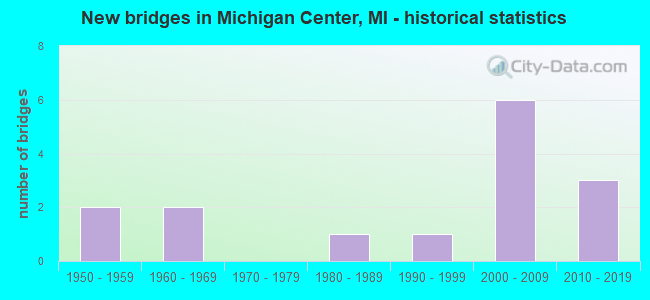
- New bridges - historical statistics
- 21950-1959
- 21960-1969
- 11980-1989
- 11990-1999
- 62000-2009
- 32010-2019

- Reconstructed bridges - Historical Statistics
- 12000-2009
- 12010-2019


- Bridge Condition - Deck
- 62.5%Good
- 37.5%Satisfactory

- Bridge Condition - Superstructure
- 12.5%Good
- 50.0%Satisfactory
- 37.5%Fair

- Bridge Condition - Substructure
- 75.0%Good
- 25.0%Satisfactory

- Bridge Condition - Channel
- 33.3%Very good
- 33.3%Good
- 33.3%Fair
Find on map >> Show street view
Structure Number: 4422, Location: 0.5 MI W OF E JCT I-94 BL (Lat: 42.277283, Lng: -84.335772), Route carried "on" structure: County highway , Year Built: 2009, Status: Open, Structure Length: 7.10m (23.29ft), Average Daily Traffic: 1,230 (year 2009), Truck Traffic: 1%, Average Future Daily Traffic: 2,650 (year 2029), Design Load: Greater than HL93, Features Intersected: I-94, Facility Carried by Structure: HAWKINS RD
Minimum Vertical Clearance: 30.48m (100.00ft), Kilometerpoint: 1.141, Lanes on structure: 2, Lanes under structure: 4, Owner: State Highway Agency, Approaching Roadway Width: 13.4m (44.0ft), Material/Design: Prestressed concrete, Design/Construction: Box Beam or Girders - Single/Spread, Number Of Spans In Main Unit: 2, Length of Maximum Span: 34.8m (114.2ft), Curb-To-Curb Width: 13.4m (44.0ft), Out-to-Out Width: 14.4m (47.2ft)
Condition: Deck: Good, Superstructure: Satisfactory, Substructure: Good, Operating Rating: 93.9 metric tons, Method Used To Determine Operating Rating: Load Factor (LF), Inventory Rating: 43.0 metric tons, Method Used To Determine Inventory Rating: Load Factor (LF), Structural Evaluation: Equal to present minimum criteria, Deck Geometry: Equal to present desirable criteria, Underclear: Equal to present minimum criteria, Approach Roadway Alignment: Equal to present minimum criteria, Designated Inspection Frequency: Every 24 months, Inspection Date: May 2021, Deck Structure Type: Concrete Cast-file-Place, Wearing Surface/Protective System: Wearing Surface: Integral Concrete, Deck Protection: Epoxy Coated Reinforcing
Find on map >> Show street view
Structure Number: 4429, Location: EAST END OF I-94 BL (Lat: 42.279333, Lng: -84.308564), Route carried "on" structure: Business Interstate 94, Year Built: 2011, Status: Open, Structure Length: 8.96m (29.40ft), Average Daily Traffic: 6,725 (year 2010), Truck Traffic: 3%, Average Future Daily Traffic: 7,912 (year 2030), Design Load: HL 93, Features Intersected: I-94
Minimum Vertical Clearance: 30.48m (100.00ft), Kilometerpoint: 0.243, Lanes on structure: 2, Lanes under structure: 4, Owner: State Highway Agency, Approaching Roadway Width: 15.8m (51.8ft), Material/Design: Prestressed concrete, Design/Construction: Box Beam or Girders - Single/Spread, Number Of Spans In Main Unit: 4, Length of Maximum Span: 31.6m (103.7ft), Curb or Sidewalk Widths: Left: 1.5m (4.9ft), Right: 0.0m, Curb-To-Curb Width: 17.1m (56.1ft), Out-to-Out Width: 20.0m (65.6ft)
Condition: Deck: Good, Superstructure: Good, Substructure: Good, Operating Rating: 57.7 metric tons, Method Used To Determine Operating Rating: Load and Resistance Factor Rating (LRFR) rating reported by rating factor(RF) method using HL-93 loadings, Inventory Rating: 43.1 metric tons, Method Used To Determine Inventory Rating: Load and Resistance Factor Rating (LRFR) rating reported by rating factor(RF) method using HL-93 loadings, Structural Evaluation: Better than present minimum criteria, Deck Geometry: Superior to present desirable criteria, Underclear: High priority of corrective action, Approach Roadway Alignment: Equal to present desirable criteria, Designated Inspection Frequency: Every 24 months, Inspection Date: July 2021, Deck Structure Type: Concrete Cast-file-Place, Wearing Surface/Protective System: Wearing Surface: Monolithic Concrete, Deck Protection: Epoxy Coated Reinforcing
Find on map >> Show street view
Structure Number: 443, Location: 1.7 MI E OF E JCT I-94 BL (Lat: 42.284356, Lng: -84.284692), Route carried "on" structure: County highway , Year Built: 1960, Year Reconstructed: 2010, Status: Open, Structure Length: 7.28m (23.88ft), Average Daily Traffic: 38,000 (year 1993), Truck Traffic: 5%, Average Future Daily Traffic: 741 (year 2030), Design Load: H 15, Features Intersected: I-94, Facility Carried by Structure: WHIPPLE RD
Minimum Vertical Clearance: 30.48m (100.00ft), Kilometerpoint: 1.249, Lanes on structure: 2, Lanes under structure: 4, Owner: State Highway Agency, Approaching Roadway Width: 9.8m (32.2ft), Skew: 3 degrees, Material/Design: Steel, Design/Construction: Stringer/Multi-beam, Number Of Spans In Main Unit: 4, Length of Maximum Span: 25.0m (82.0ft), Curb or Sidewalk Widths: Left: 0.7m (2.3ft), Right: 0.7m (2.3ft), Curb-To-Curb Width: 7.3m (24.0ft), Out-to-Out Width: 9.5m (31.2ft)
Condition: Deck: Good, Superstructure: Fair, Substructure: Satisfactory, Operating Rating: 58.8 metric tons, Method Used To Determine Operating Rating: Load Factor (LF), Inventory Rating: 35.3 metric tons, Method Used To Determine Inventory Rating: Load Factor (LF), Structural Evaluation: Somewhat better than minimum adequacy, Deck Geometry: High priority of replacement, Underclear: Meets minimum limits, Approach Roadway Alignment: Equal to present desirable criteria, Designated Inspection Frequency: Every 24 months, Inspection Date: July 2021, Deck Structure Type: Concrete Cast-file-Place, Wearing Surface/Protective System: Wearing Surface: Epoxy Overlay, Deck Protection: Epoxy Coated Reinforcing
Find on map >> Show street view
Structure Number: 4448, Location: 1.4 MI S OF I-94 BL (Lat: 42.239725, Lng: -84.355661), Route carried "on" structure: County highway 2009, Year Built: 1958, Year Reconstructed: 2011, Status: Open, Structure Length: 6.29m (20.64ft), Average Daily Traffic: 20,650 (year 2010), Truck Traffic: 6%, Average Future Daily Traffic: 22,600 (year 2030), Design Load: H 20, Features Intersected: US-127, Facility Carried by Structure: PAGE RD
Minimum Vertical Clearance: 30.48m (100.00ft), Kilometerpoint: 3.417, Lanes on structure: 4, Lanes under structure: 4, Base Highway Network: Yes (Inventory Route: 90, Subroute: 2), Owner: State Highway Agency, Approaching Roadway Width: 15.8m (51.8ft), Material/Design: Steel, Design/Construction: Stringer/Multi-beam, Number Of Spans In Main Unit: 4, Length of Maximum Span: 16.0m (52.5ft), Curb or Sidewalk Widths: Left: 2.4m (7.9ft), Right: 2.4m (7.9ft), Curb-To-Curb Width: 15.8m (51.8ft), Out-to-Out Width: 22.0m (72.2ft)
Condition: Deck: Satisfactory, Superstructure: Fair, Substructure: Satisfactory, Operating Rating: 78.1 metric tons, Method Used To Determine Operating Rating: Load Factor (LF), Inventory Rating: 46.8 metric tons, Method Used To Determine Inventory Rating: Load Factor (LF), Structural Evaluation: Somewhat better than minimum adequacy, Deck Geometry: Meets minimum limits, Underclear: Meets minimum limits, Approach Roadway Alignment: Equal to present desirable criteria, Designated Inspection Frequency: Every 24 months, Inspection Date: June 2021, Deck Structure Type: Concrete Cast-file-Place, Wearing Surface/Protective System: Wearing Surface: Monolithic Concrete, Deck Protection: Epoxy Coated Reinforcing
Find on map >> Show street view
Structure Number: 4449, Location: @ I-94 BL (Lat: 42.257664, Lng: -84.356892), Route carried "on" structure: US 127, Year Built: 2001, Status: Open, Structure Length: 5.11m (16.77ft), Average Daily Traffic: 13,207 (year 2007), Truck Traffic: 18%, Average Future Daily Traffic: 10,108 (year 2018), Design Load: HS 25 or greater, Features Intersected: I-94 BL
Minimum Vertical Clearance: 30.48m (100.00ft), Kilometerpoint: 7.719, Lanes on structure: 2, Lanes under structure: 5, Base Highway Network: Yes (Inventory Route: 89, Subroute: 9), Owner: State Highway Agency, Approaching Roadway Width: 12.0m (39.4ft), Skew: 11 degrees, Material/Design: Prestressed concrete, Design/Construction: Box Beam or Girders - Multiple, Number Of Spans In Main Unit: 3, Length of Maximum Span: 29.5m (96.8ft), Curb-To-Curb Width: 13.2m (43.3ft), Out-to-Out Width: 14.2m (46.6ft)
Condition: Deck: Good, Superstructure: Satisfactory, Substructure: Good, Operating Rating: 82.9 metric tons, Method Used To Determine Operating Rating: Load Factor (LF) rating reported by rating factor (RF) method using MS18 loading, Inventory Rating: 32.4 metric tons, Method Used To Determine Inventory Rating: Load Factor (LF) rating reported by rating factor (RF) method using MS18 loading, Structural Evaluation: Equal to present minimum criteria, Deck Geometry: Superior to present desirable criteria, Underclear: Meets minimum limits, Approach Roadway Alignment: Equal to present desirable criteria, Designated Inspection Frequency: Every 24 months, Inspection Date: June 2021, Deck Structure Type: Concrete Cast-file-Place, Wearing Surface/Protective System: Wearing Surface: Monolithic Concrete, Deck Protection: Epoxy Coated Reinforcing
Find on map >> Show street view
Structure Number: 445, Location: @ I-94 BL (Lat: 42.257611, Lng: -84.357103), Route carried "on" structure: US 127, Year Built: 2001, Status: Open, Structure Length: 5.11m (16.77ft), Average Daily Traffic: 13,207 (year 2007), Truck Traffic: 18%, Average Future Daily Traffic: 10,108 (year 2018), Design Load: HS 25 or greater, Features Intersected: I-94BL
Minimum Vertical Clearance: 30.48m (100.00ft), Kilometerpoint: 7.712, Lanes on structure: 2, Lanes under structure: 5, Base Highway Network: Yes (Inventory Route: 89, Subroute: 10), Owner: State Highway Agency, Approaching Roadway Width: 12.0m (39.4ft), Skew: 11 degrees, Material/Design: Prestressed concrete, Design/Construction: Box Beam or Girders - Multiple, Number Of Spans In Main Unit: 3, Length of Maximum Span: 29.5m (96.8ft), Curb or Sidewalk Widths: Left: 0.4m (1.3ft), Right: 0.4m (1.3ft), Curb-To-Curb Width: 13.2m (43.3ft), Out-to-Out Width: 14.2m (46.6ft)
Condition: Deck: Good, Superstructure: Satisfactory, Substructure: Good, Operating Rating: 82.9 metric tons, Method Used To Determine Operating Rating: Load Factor (LF) rating reported by rating factor (RF) method using MS18 loading, Inventory Rating: 32.4 metric tons, Method Used To Determine Inventory Rating: Load Factor (LF) rating reported by rating factor (RF) method using MS18 loading, Structural Evaluation: Equal to present minimum criteria, Deck Geometry: Superior to present desirable criteria, Underclear: Meets minimum limits, Approach Roadway Alignment: Equal to present desirable criteria, Designated Inspection Frequency: Every 24 months, Inspection Date: June 2021, Deck Structure Type: Concrete Cast-file-Place, Wearing Surface/Protective System: Wearing Surface: Monolithic Concrete, Deck Protection: Epoxy Coated Reinforcing
Find on map >> Show street view
Structure Number: 4474, Location: 1M S 1.5M W MICHIGAN CENT (Lat: 42.217783, Lng: -84.351136), Route carried "on" structure: County highway 2009, Year Built: 1987, Status: Open, Structure Length: 1.28m (4.20ft), Average Daily Traffic: 8,546 (year 2004), Average Future Daily Traffic: 100,000 (year 2020), Design Load: HS 20, Features Intersected: GRAND RIVER, Facility Carried by Structure: SOUTH STREET
Minimum Vertical Clearance: 30.48m (100.00ft), Kilometerpoint: 5.507, Lanes on structure: 2, Owner: County Highway Agency, Approaching Roadway Width: 9.4m (30.8ft), Skew: 3 degrees, Material/Design: Prestressed concrete, Design/Construction: Box Beam or Girders - Multiple, Number Of Spans In Main Unit: 1, Length of Maximum Span: 12.8m (42.0ft), Curb-To-Curb Width: 12.2m (40.0ft), Out-to-Out Width: 13.2m (43.3ft)
Condition: Deck: Satisfactory, Superstructure: Fair, Substructure: Good, Channel: Good, Operating Rating: 61.2 metric tons, Method Used To Determine Operating Rating: Load Factor (LF), Inventory Rating: 36.7 metric tons, Method Used To Determine Inventory Rating: Load Factor (LF), Structural Evaluation: Somewhat better than minimum adequacy, Deck Geometry: Somewhat better than minimum adequacy, Waterway Adequacy: Equal to present desirable criteria, Approach Roadway Alignment: Meets minimum limits, Designated Inspection Frequency: Every 24 months, Inspection Date: May 2021, Deck Structure Type: Concrete Cast-file-Place, Wearing Surface/Protective System: Wearing Surface: Bituminous, Deck Protection: Epoxy Coated Reinforcing
Find on map >> Show street view
Structure Number: 4475, Location: 2 MI E OF MICHIGAN CENTER (Lat: 42.218347, Lng: -84.292281), Route carried "on" structure: County highway 2009, Year Built: 1990, Status: Open, Structure Length: 1.03m (3.38ft), Average Daily Traffic: 1,000 (year 1994), Average Future Daily Traffic: 1,700 (year 2014), Design Load: HS 20, Features Intersected: CREEK, Facility Carried by Structure: LEE ROAD
Minimum Vertical Clearance: 30.48m (100.00ft), Kilometerpoint: 0.311, Lanes on structure: 2, Owner: County Highway Agency, Approaching Roadway Width: 10.4m (34.1ft), Material/Design: Prestressed concrete, Design/Construction: Box Beam or Girders - Multiple, Number Of Spans In Main Unit: 1, Length of Maximum Span: 9.4m (30.8ft), Curb-To-Curb Width: 9.4m (30.8ft), Out-to-Out Width: 10.4m (34.1ft)
Condition: Deck: Satisfactory, Superstructure: Satisfactory, Substructure: Good, Channel: Fair, Operating Rating: 60.6 metric tons, Method Used To Determine Operating Rating: Load Factor (LF), Inventory Rating: 36.3 metric tons, Method Used To Determine Inventory Rating: Load Factor (LF), Structural Evaluation: Equal to present minimum criteria, Deck Geometry: Equal to present minimum criteria, Waterway Adequacy: Equal to present desirable criteria, Approach Roadway Alignment: Equal to present desirable criteria, Designated Inspection Frequency: Every 24 months, Inspection Date: May 2021, Deck Structure Type: Other, Wearing Surface/Protective System: Wearing Surface: Bituminous
Find on map >> Show street view
Structure Number: 4515, Location: 2.5 M N 1.8 M W NAPOLEON (Lat: 42.196775, Lng: -84.280800), Route carried "on" structure: County highway , Year Built: 2019, Status: Open, Structure Length: 0.88m (2.89ft), Average Daily Traffic: 1,050 (year 2018), Truck Traffic: 1%, Average Future Daily Traffic: 1,281 (year 2038), Design Load: Greater than HL93, Features Intersected: DOLLAR LAKE CHANNEL, Facility Carried by Structure: MOON LAKE ROAD
Minimum Vertical Clearance: 30.48m (100.00ft), Kilometerpoint: 3.064, Lanes on structure: 2, Owner: County Highway Agency, Approaching Roadway Width: 9.8m (32.2ft), Material/Design: Concrete, Design/Construction: Culvert, Number Of Spans In Main Unit: 1, Length of Maximum Span: 8.8m (28.9ft), Curb-To-Curb Width: 9.9m (32.5ft), Out-to-Out Width: 10.7m (35.1ft)
Condition: Channel: Very good, Culverts: Very good, Operating Rating: 74.5 metric tons, Method Used To Determine Operating Rating: Load and Resistance Factor Rating (LRFR) rating reported by rating factor(RF) method using HL-93 loadings, Inventory Rating: 61.6 metric tons, Method Used To Determine Inventory Rating: Load and Resistance Factor Rating (LRFR) rating reported by rating factor(RF) method using HL-93 loadings, Structural Evaluation: Equal to present desirable criteria, Deck Geometry: Somewhat better than minimum adequacy, Waterway Adequacy: Better than present minimum criteria, Approach Roadway Alignment: Somewhat better than minimum adequacy, Length Of Structure Improvement: 5.00m (16.40ft), Designated Inspection Frequency: Every 24 months, Inspection Date: July 2021, Bridge Improvement Cost: $556,000, Roadway Improvement Cost: $350,000, Total Project Cost: $906,000 ( Estimate for 2016), Wearing Surface/Protective System: Wearing Surface: Bituminous
Find on map >> Show street view
Structure Number: 4422, Location: 0.5 MI W OF E JCT I-94 BL (Lat: 42.277283, Lng: -84.335772), Route carried "under" structure: Interstate 94, Year Built: 2009, Structure Length: 0. m, Average Daily Traffic: 45,500 (year 2007), Truck Traffic: 17%, Features Intersected: I-94, Facility Carried by Structure: HAWKINS RD
Minimum Vertical Clearance: 5.51m (18.08ft), Kilometerpoint: 31.760, Lanes on structure: 2, Lanes under structure: 4, Material/Design: Prestressed concrete, Design/Construction: Box Beam or Girders - Single/Spread, Length of Maximum Span: 34.8m (114.2ft)
Find on map >> Show street view
Structure Number: 4429, Location: EAST END OF I-94 BL (Lat: 42.279333, Lng: -84.308564), Route carried "under" structure: Interstate 94, Year Built: 2011, Structure Length: 0. m, Average Daily Traffic: 48,800 (year 2007), Truck Traffic: 17%, Features Intersected: I-94
Minimum Vertical Clearance: 5.69m (18.67ft), Kilometerpoint: 34.094, Lanes on structure: 2, Lanes under structure: 4, Material/Design: Prestressed concrete, Design/Construction: Box Beam or Girders - Single/Spread, Length of Maximum Span: 31.6m (103.7ft)
Find on map >> Show street view
Structure Number: 443, Location: 1.7 MI E OF E JCT I-94 BL (Lat: 42.284356, Lng: -84.284692), Route carried "under" structure: Interstate 94, Year Built: 1960, Structure Length: 0. m, Average Daily Traffic: 46,034 (year 2007), Truck Traffic: 17%, Features Intersected: I-94, Facility Carried by Structure: WHIPPLE RD
Minimum Vertical Clearance: 5.00m (16.40ft), Kilometerpoint: 36.136, Lanes on structure: 2, Lanes under structure: 4, Material/Design: Steel, Design/Construction: Stringer/Multi-beam, Length of Maximum Span: 25.0m (82.0ft)
Find on map >> Show street view
Structure Number: 4448, Location: 1.4 MI S OF I-94 BL (Lat: 42.239725, Lng: -84.355661), Route carried "under" structure: US 127, Year Built: 1958, Structure Length: 0. m, Average Daily Traffic: 26,800 (year 2010), Truck Traffic: 11%, Features Intersected: US-127, Facility Carried by Structure: PAGE RD
Minimum Vertical Clearance: 4.95m (16.24ft), Kilometerpoint: 5.723, Lanes on structure: 4, Lanes under structure: 4, Material/Design: Steel, Design/Construction: Stringer/Multi-beam, Length of Maximum Span: 16.0m (52.5ft)
Find on map >> Show street view
Structure Number: 4449, Location: @ I-94 BL (Lat: 42.257664, Lng: -84.356892), Route carried "under" structure: Business Interstate 94, Year Built: 2001, Structure Length: 0. m, Average Daily Traffic: 18,430 (year 2007), Truck Traffic: 10%, Features Intersected: I-94 BL, Facility Carried by Structure: US-127 NB
Minimum Vertical Clearance: 5.26m (17.26ft), Kilometerpoint: 0.018, Lanes on structure: 2, Lanes under structure: 5, Material/Design: Prestressed concrete, Design/Construction: Box Beam or Girders - Multiple, Length of Maximum Span: 29.5m (96.8ft)
Find on map >> Show street view
Structure Number: 445, Location: @ I-94 BL (Lat: 42.257611, Lng: -84.357103), Route carried "under" structure: Business Interstate 94, Year Built: 2001, Structure Length: 0. m, Average Daily Traffic: 18,430 (year 2007), Truck Traffic: 3%, Features Intersected: I-94BL, Facility Carried by Structure: US-127 SB
Minimum Vertical Clearance: 5.16m (16.93ft), Kilometerpoint: 0.000, Lanes on structure: 2, Lanes under structure: 5, Material/Design: Prestressed concrete, Design/Construction: Box Beam or Girders - Multiple, Length of Maximum Span: 29.5m (96.8ft)