Bridge Statistics for Mexico, Pennsylvania (PA)
Condition, Traffic, Stress, Structural Evaluation, Project Costs
- National Bridge Inventory (NBI) Statistics
- 17Number of bridges
- 105ft / 32.1mTotal length
- $3,585,000Total costs
- 63,669Total average daily traffic
- 13,188Total average daily truck traffic
- National Bridge Inventory (NBI) Registered Bridges for Mexico
- No street view available for this location
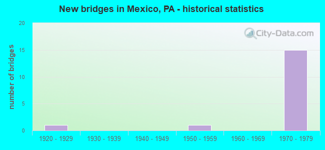
- New bridges - historical statistics
- 11920-1929
- 11950-1959
- 151970-1979

- Reconstructed bridges - Historical Statistics
- 61990-1999
- 12000-2009


- Bridge Condition - Deck
- 12.5%Good
- 37.5%Satisfactory
- 25.0%Fair
- 25.0%Poor

- Bridge Condition - Superstructure
- 11.1%Very good
- 44.4%Satisfactory
- 44.4%Fair

- Bridge Condition - Substructure
- 33.3%Satisfactory
- 66.7%Fair

- Bridge Condition - Channel
- 20.0%Good
- 40.0%Satisfactory
- 40.0%Fair
Find on map >> Show street view
Structure Number: 19927, Location: 1 MI E MIFFLINTOWN (Lat: 40.574389, Lng: -77.368836), Route carried "on" structure: US 22, Year Built: 1974, Year Reconstructed: 2001, Status: Open, Structure Length: 4.02m (13.19ft), Average Daily Traffic: 6,671 (year 2021), Truck Traffic: 25%, Average Future Daily Traffic: 9,979 (year 2041), Design Load: HS 20, Features Intersected: SR 2006
Minimum Vertical Clearance: 30+ m (98+ ft), Kilometerpoint: 13.189, Lanes on structure: 2, Lanes under structure: 2, Base Highway Network: Yes, Owner: State Highway Agency, Approaching Roadway Width: 11.6m (38.1ft), Material/Design: Prestressed concrete, Design/Construction: Stringer/Multi-beam, Number Of Spans In Main Unit: 3, Length of Maximum Span: 17.1m (56.1ft), Curb or Sidewalk Widths: Left: 0.2m (0.7ft), Right: 0.2m (0.7ft), Curb-To-Curb Width: 12.0m (39.4ft), Out-to-Out Width: 13.2m (43.3ft)
Condition: Deck: Satisfactory, Superstructure: Fair, Substructure: Fair, Operating Rating: 77.1 metric tons, Method Used To Determine Operating Rating: Load Factor (LF), Inventory Rating: 33.6 metric tons, Method Used To Determine Inventory Rating: Load Factor (LF), Structural Evaluation: Somewhat better than minimum adequacy, Deck Geometry: Better than present minimum criteria, Underclear: Better than present minimum criteria, Approach Roadway Alignment: Equal to present desirable criteria, Length Of Structure Improvement: 4.00m (13.12ft), Designated Inspection Frequency: Every 24 months, Inspection Date: August 2021, Bridge Improvement Cost: $34,000, Roadway Improvement Cost: $250,000, Total Project Cost: $458,000, Deck Structure Type: Concrete Cast-file-Place, Wearing Surface/Protective System: Wearing Surface: Epoxy Overlay
Find on map >> Show street view
Structure Number: 19928, Location: 1 MI E MIFFLINTOWN (Lat: 40.574522, Lng: -77.368478), Route carried "on" structure: US 22, Year Built: 1974, Year Reconstructed: 2001, Status: Open, Structure Length: 3.90m (12.80ft), Average Daily Traffic: 7,021 (year 2021), Truck Traffic: 22%, Average Future Daily Traffic: 10,502 (year 2041), Design Load: HS 20, Features Intersected: SR 2006
Minimum Vertical Clearance: 30+ m (98+ ft), Kilometerpoint: 13.163, Lanes on structure: 2, Lanes under structure: 2, Base Highway Network: Yes, Owner: State Highway Agency, Approaching Roadway Width: 11.6m (38.1ft), Material/Design: Prestressed concrete, Design/Construction: Stringer/Multi-beam, Number Of Spans In Main Unit: 3, Length of Maximum Span: 17.1m (56.1ft), Curb or Sidewalk Widths: Left: 0.2m (0.7ft), Right: 0.2m (0.7ft), Curb-To-Curb Width: 12.0m (39.4ft), Out-to-Out Width: 13.2m (43.3ft)
Condition: Deck: Satisfactory, Superstructure: Satisfactory, Substructure: Fair, Operating Rating: 78.0 metric tons, Method Used To Determine Operating Rating: Load Factor (LF), Inventory Rating: 33.6 metric tons, Method Used To Determine Inventory Rating: Load Factor (LF), Structural Evaluation: Somewhat better than minimum adequacy, Deck Geometry: Better than present minimum criteria, Underclear: Better than present minimum criteria, Approach Roadway Alignment: Equal to present desirable criteria, Length Of Structure Improvement: 3.90m (12.80ft), Designated Inspection Frequency: Every 24 months, Inspection Date: August 2021, Bridge Improvement Cost: $34,000, Roadway Improvement Cost: $250,000, Total Project Cost: $453,000, Deck Structure Type: Concrete Cast-file-Place, Wearing Surface/Protective System: Wearing Surface: Monolithic Concrete
Find on map >> Show street view
Structure Number: 19931, Location: MEXICO (Lat: 40.544278, Lng: -77.350147), Route carried "on" structure: US 22, Year Built: 1972, Year Reconstructed: 2001, Status: Open, Structure Length: 7.59m (24.90ft), Average Daily Traffic: 6,671 (year 2021), Truck Traffic: 25%, Average Future Daily Traffic: 9,979 (year 2041), Design Load: HS 20, Features Intersected: SR 2003 AND DOE RUN
Minimum Vertical Clearance: 30+ m (98+ ft), Kilometerpoint: 17.012, Lanes on structure: 2, Lanes under structure: 2, Base Highway Network: Yes, Owner: State Highway Agency, Approaching Roadway Width: 12.2m (40.0ft), Skew: 3 degrees, Material/Design: Prestressed concrete, Design/Construction: Stringer/Multi-beam, Number Of Spans In Main Unit: 3, Length of Maximum Span: 29.6m (97.1ft), Curb or Sidewalk Widths: Left: 0.2m (0.7ft), Right: 0.2m (0.7ft), Curb-To-Curb Width: 12.0m (39.4ft), Out-to-Out Width: 13.2m (43.3ft)
Condition: Deck: Poor, Superstructure: Fair, Substructure: Satisfactory, Channel: Good, Operating Rating: 68.9 metric tons, Method Used To Determine Operating Rating: Load Factor (LF), Inventory Rating: 37.2 metric tons, Method Used To Determine Inventory Rating: Load Factor (LF), Structural Evaluation: Somewhat better than minimum adequacy, Deck Geometry: Better than present minimum criteria, Underclear: Better than present minimum criteria, Waterway Adequacy: Superior to present desirable criteria, Approach Roadway Alignment: Equal to present desirable criteria, Length Of Structure Improvement: 7.50m (24.61ft), Designated Inspection Frequency: Every 24 months, Inspection Date: August 2021, Deck Structure Type: Concrete Cast-file-Place, Wearing Surface/Protective System: Wearing Surface: Epoxy Overlay
Find on map >> Show street view
Structure Number: 19933, Location: MEXICO (Lat: 40.544472, Lng: -77.350058), Route carried "on" structure: US 22, Year Built: 1972, Year Reconstructed: 2001, Status: Open, Structure Length: 7.50m (24.61ft), Average Daily Traffic: 7,021 (year 2021), Truck Traffic: 22%, Average Future Daily Traffic: 10,502 (year 2041), Design Load: HS 20, Features Intersected: SR 2003 AND DOE RUN
Minimum Vertical Clearance: 30+ m (98+ ft), Kilometerpoint: 17.028, Lanes on structure: 2, Lanes under structure: 2, Base Highway Network: Yes, Owner: State Highway Agency, Approaching Roadway Width: 11.6m (38.1ft), Skew: 3 degrees, Material/Design: Prestressed concrete, Design/Construction: Stringer/Multi-beam, Number Of Spans In Main Unit: 3, Length of Maximum Span: 29.6m (97.1ft), Curb or Sidewalk Widths: Left: 0.2m (0.7ft), Right: 0.2m (0.7ft), Curb-To-Curb Width: 12.0m (39.4ft), Out-to-Out Width: 13.2m (43.3ft)
Condition: Deck: Poor, Superstructure: Satisfactory, Substructure: Satisfactory, Channel: Satisfactory, Operating Rating: 79.8 metric tons, Method Used To Determine Operating Rating: Load Factor (LF), Inventory Rating: 34.5 metric tons, Method Used To Determine Inventory Rating: Load Factor (LF), Structural Evaluation: Equal to present minimum criteria, Deck Geometry: Better than present minimum criteria, Underclear: Somewhat better than minimum adequacy, Waterway Adequacy: Superior to present desirable criteria, Approach Roadway Alignment: Equal to present desirable criteria, Length Of Structure Improvement: 7.50m (24.61ft), Designated Inspection Frequency: Every 24 months, Inspection Date: August 2021, Bridge Improvement Cost: $58,000, Roadway Improvement Cost: $250,000, Total Project Cost: $783,000, Deck Structure Type: Concrete Cast-file-Place, Wearing Surface/Protective System: Wearing Surface: Epoxy Overlay
Find on map >> Show street view
Structure Number: 19936, Location: 4 MI W THOMPSONTOWN (Lat: 40.547778, Lng: -77.313292), Route carried "on" structure: US 22, Year Built: 1972, Year Reconstructed: 2001, Status: Open, Structure Length: 3.11m (10.20ft), Average Daily Traffic: 6,671 (year 2021), Truck Traffic: 25%, Average Future Daily Traffic: 9,979 (year 2041), Design Load: HS 20+Mod, Features Intersected: SR 2005
Minimum Vertical Clearance: 30+ m (98+ ft), Kilometerpoint: 20.936, Lanes on structure: 2, Lanes under structure: 2, Base Highway Network: Yes, Owner: State Highway Agency, Approaching Roadway Width: 11.6m (38.1ft), Skew: 1 degrees, Material/Design: Prestressed concrete, Design/Construction: Stringer/Multi-beam, Number Of Spans In Main Unit: 1, Length of Maximum Span: 30.2m (99.1ft), Curb or Sidewalk Widths: Left: 0.2m (0.7ft), Right: 0.2m (0.7ft), Curb-To-Curb Width: 12.0m (39.4ft), Out-to-Out Width: 13.3m (43.6ft)
Condition: Deck: Fair, Superstructure: Fair, Substructure: Fair, Operating Rating: 98.9 metric tons, Method Used To Determine Operating Rating: Load Factor (LF), Inventory Rating: 33.6 metric tons, Method Used To Determine Inventory Rating: Load Factor (LF), Structural Evaluation: Somewhat better than minimum adequacy, Deck Geometry: Better than present minimum criteria, Underclear: Meets minimum limits, Approach Roadway Alignment: Equal to present desirable criteria, Length Of Structure Improvement: 3.10m (10.17ft), Designated Inspection Frequency: Every 24 months, Inspection Date: August 2021, Bridge Improvement Cost: $32,000, Roadway Improvement Cost: $250,000, Total Project Cost: $431,000, Deck Structure Type: Concrete Cast-file-Place, Wearing Surface/Protective System: Wearing Surface: Latex Concrete
Find on map >> Show street view
Structure Number: 19937, Location: 4 MI W THOMPSONTOWN (Lat: 40.547969, Lng: -77.313606), Route carried "on" structure: US 22, Year Built: 1972, Year Reconstructed: 2001, Status: Open, Structure Length: 3.11m (10.20ft), Average Daily Traffic: 7,021 (year 2021), Truck Traffic: 22%, Average Future Daily Traffic: 10,502 (year 2041), Design Load: HS 20+Mod, Features Intersected: SR 2005
Minimum Vertical Clearance: 30+ m (98+ ft), Kilometerpoint: 20.849, Lanes on structure: 2, Lanes under structure: 2, Base Highway Network: Yes, Owner: State Highway Agency, Approaching Roadway Width: 11.6m (38.1ft), Skew: 1 degrees, Material/Design: Prestressed concrete, Design/Construction: Stringer/Multi-beam, Number Of Spans In Main Unit: 1, Length of Maximum Span: 29.6m (97.1ft), Curb or Sidewalk Widths: Left: 0.2m (0.7ft), Right: 0.2m (0.7ft), Curb-To-Curb Width: 12.0m (39.4ft), Out-to-Out Width: 13.3m (43.6ft)
Condition: Deck: Fair, Superstructure: Fair, Substructure: Fair, Inventory Rating: 35.4 metric tons, Method Used To Determine Inventory Rating: Load Factor (LF), Structural Evaluation: Somewhat better than minimum adequacy, Deck Geometry: Better than present minimum criteria, Underclear: Meets minimum limits, Approach Roadway Alignment: Equal to present desirable criteria, Length Of Structure Improvement: 3.10m (10.17ft), Designated Inspection Frequency: Every 24 months, Inspection Date: August 2021, Bridge Improvement Cost: $32,000, Roadway Improvement Cost: $250,000, Total Project Cost: $431,000, Deck Structure Type: Concrete Cast-file-Place, Wearing Surface/Protective System: Wearing Surface: Epoxy Overlay
Find on map >> Show street view
Structure Number: 2022, Location: MEXICO (Lat: 40.536103, Lng: -77.351517), Route carried "on" structure: State highway , Year Built: 1928, Status: Open, Structure Length: 0.88m (2.89ft), Average Daily Traffic: 3,047 (year 2022), Truck Traffic: 4%, Average Future Daily Traffic: 3,508 (year 2041), Design Load: H 15, Features Intersected: DOE RUN, Facility Carried by Structure: SR 3002
Minimum Vertical Clearance: 30+ m (98+ ft), Kilometerpoint: 9.114, Lanes on structure: 2, Owner: State Highway Agency, Approaching Roadway Width: 7.6m (24.9ft), Material/Design: Concrete, Design/Construction: Arch - Deck, Number Of Spans In Main Unit: 1, Length of Maximum Span: 8.8m (28.9ft), Curb or Sidewalk Widths: Left: 0.1m (0.3ft), Right: 0.1m (0.3ft), Curb-To-Curb Width: 11.9m (39.0ft), Out-to-Out Width: 12.3m (40.4ft)
Condition: Superstructure: Satisfactory, Substructure: Fair, Channel: Fair, Operating Rating: 35.4 metric tons, Method Used To Determine Operating Rating: Field evaluation and documented engineering judgment, Inventory Rating: 32.7 metric tons, Method Used To Determine Inventory Rating: Field evaluation and documented engineering judgment, Structural Evaluation: Somewhat better than minimum adequacy, Deck Geometry: Somewhat better than minimum adequacy, Waterway Adequacy: Better than present minimum criteria, Approach Roadway Alignment: Equal to present desirable criteria, Length Of Structure Improvement: 0.90m (2.95ft), Designated Inspection Frequency: Every 24 months, Inspection Date: October 2021, Bridge Improvement Cost: $27,000, Roadway Improvement Cost: $250,000, Total Project Cost: $363,000
Find on map >> Show street view
Structure Number: 20354, Location: 1 MILE N.OF MEXICO (Lat: 40.551681, Lng: -77.356719), Route carried "on" structure: ServiceCity street , Year Built: 1973, Status: Open, Structure Length: 0.91m (2.99ft), Average Daily Traffic: 500 (year 2011), Truck Traffic: 3%, Average Future Daily Traffic: 700 (year 2031), Design Load: HS 20, Features Intersected: CEDAR SPRING RUN, Facility Carried by Structure: T-351 DEERVILLE RD
Minimum Vertical Clearance: 30+ m (98+ ft), Kilometerpoint: 0.000, Lanes on structure: 2, Owner: Town or Township Highway Agency, Approaching Roadway Width: 11.0m (36.1ft), Skew: 2 degrees, Material/Design: Concrete, Design/Construction: Slab, Number Of Spans In Main Unit: 1, Length of Maximum Span: 8.5m (27.9ft), Curb-To-Curb Width: 10.9m (35.8ft), Out-to-Out Width: 12.7m (41.7ft)
Condition: Deck: Satisfactory, Superstructure: Satisfactory, Substructure: Fair, Channel: Satisfactory, Operating Rating: 73.5 metric tons, Method Used To Determine Operating Rating: Field evaluation and documented engineering judgment, Inventory Rating: 44.5 metric tons, Method Used To Determine Inventory Rating: Field evaluation and documented engineering judgment, Structural Evaluation: Somewhat better than minimum adequacy, Deck Geometry: Equal to present minimum criteria, Waterway Adequacy: Equal to present desirable criteria, Approach Roadway Alignment: Equal to present minimum criteria, Length Of Structure Improvement: 1.60m (5.25ft), Designated Inspection Frequency: Every 24 months, Inspection Date: October 2021, Deck Structure Type: Concrete Cast-file-Place, Wearing Surface/Protective System: Wearing Surface: Bituminous
Find on map >> Show street view
Structure Number: 20355, Location: 600 FT NORTH OF SR 2005 (Lat: 40.567917, Lng: -77.308550), Route carried "on" structure: City street , Year Built: 1955, Year Reconstructed: 2013, Status: Open, Structure Length: 1.10m (3.61ft), Average Daily Traffic: 50 (year 2014), Truck Traffic: 5%, Average Future Daily Traffic: 63 (year 2034), Design Load: HL 93, Features Intersected: DOE RUN, Facility Carried by Structure: T-455 RED ROCK RD
Minimum Vertical Clearance: 30+ m (98+ ft), Kilometerpoint: 0.000, Lanes on structure: 2, Owner: Town or Township Highway Agency, Approaching Roadway Width: 5.5m (18.0ft), Skew: 5 degrees, Material/Design: Steel continuous, Design/Construction: Stringer/Multi-beam, Number Of Spans In Main Unit: 2, Length of Maximum Span: 5.8m (19.0ft), Curb-To-Curb Width: 5.7m (18.7ft), Out-to-Out Width: 6.7m (22.0ft)
Condition: Deck: Good, Superstructure: Very good, Substructure: Satisfactory, Channel: Fair, Operating Rating: 73.2 metric tons, Method Used To Determine Operating Rating: Assigned ratings based on Load and Resistance Factor Design (LRFD) reported by rating factor (RF) using HL93 loadings, Inventory Rating: 46.0 metric tons, Method Used To Determine Inventory Rating: Assigned ratings based on Load and Resistance Factor Design (LRFD) reported by rating factor (RF) using HL93 loadings, Structural Evaluation: Equal to present minimum criteria, Deck Geometry: Meets minimum limits, Waterway Adequacy: Equal to present minimum criteria, Approach Roadway Alignment: Equal to present desirable criteria, Length Of Structure Improvement: 1.30m (4.27ft), Designated Inspection Frequency: Every 24 months, Inspection Date: October 2021, Bridge Improvement Cost: $49,000, Roadway Improvement Cost: $264,000, Total Project Cost: $666,000, Deck Structure Type: Concrete Cast-file-Place, Wearing Surface/Protective System: Wearing Surface: Monolithic Concrete, Deck Protection: Epoxy Coated Reinforcing
Find on map >> Show street view
Structure Number: 19927, Location: 1 MI E MIFFLINTOWN (Lat: 40.574389, Lng: -77.368836), Route carried "under" structure: State highway , Year Built: 1974, Structure Length: 0. m, Average Daily Traffic: 1,873 (year 2021), Truck Traffic: 2%, Features Intersected: SR 2006, Facility Carried by Structure: SR 22-US 22
Minimum Vertical Clearance: 4.78m (15.68ft), Kilometerpoint: 2.272, Lanes on structure: 2, Lanes under structure: 2, Material/Design: Prestressed concrete, Design/Construction: Stringer/Multi-beam, Length of Maximum Span: 17.1m (56.1ft)
Find on map >> Show street view
Structure Number: 19928, Location: 1 MI E MIFFLINTOWN (Lat: 40.574522, Lng: -77.368478), Route carried "under" structure: State highway , Year Built: 1974, Structure Length: 0. m, Average Daily Traffic: 1,873 (year 2021), Truck Traffic: 2%, Features Intersected: SR 2006, Facility Carried by Structure: SR 22-US 22
Minimum Vertical Clearance: 4.86m (15.94ft), Kilometerpoint: 2.272, Lanes on structure: 2, Lanes under structure: 2, Material/Design: Prestressed concrete, Design/Construction: Stringer/Multi-beam, Length of Maximum Span: 17.1m (56.1ft)
Find on map >> Show street view
Structure Number: 19931, Location: MEXICO (Lat: 40.544278, Lng: -77.350147), Route carried "under" structure: State highway , Year Built: 1972, Structure Length: 0. m, Average Daily Traffic: 189 (year 2019), Truck Traffic: 7%, Features Intersected: SR 2003 AND DOE RUN, Facility Carried by Structure: SR 22-US 22
Minimum Vertical Clearance: 4.74m (15.55ft), Kilometerpoint: 0.766, Lanes on structure: 2, Lanes under structure: 2, Material/Design: Prestressed concrete, Design/Construction: Stringer/Multi-beam, Length of Maximum Span: 29.6m (97.1ft)
Find on map >> Show street view
Structure Number: 19933, Location: MEXICO (Lat: 40.544472, Lng: -77.350058), Route carried "under" structure: State highway , Year Built: 1972, Structure Length: 0. m, Average Daily Traffic: 189 (year 2019), Truck Traffic: 7%, Features Intersected: SR 2003 AND DOE RUN, Facility Carried by Structure: SR 22-US 22
Minimum Vertical Clearance: 4.37m (14.34ft), Kilometerpoint: 0.766, Lanes on structure: 2, Lanes under structure: 2, Material/Design: Prestressed concrete, Design/Construction: Stringer/Multi-beam, Length of Maximum Span: 29.6m (97.1ft)
Find on map >> Show street view
Structure Number: 19936, Location: 4 MI W THOMPSONTOWN (Lat: 40.547778, Lng: -77.313292), Route carried "under" structure: State highway , Year Built: 1972, Structure Length: 0. m, Average Daily Traffic: 590 (year 2022), Truck Traffic: 9%, Features Intersected: SR 2005, Facility Carried by Structure: SR 22-US 22
Minimum Vertical Clearance: 4.28m (14.04ft), Kilometerpoint: 0.000, Lanes on structure: 2, Lanes under structure: 2, Material/Design: Prestressed concrete, Design/Construction: Stringer/Multi-beam, Length of Maximum Span: 30.2m (99.1ft)
Find on map >> Show street view
Structure Number: 19937, Location: 4 MI W THOMPSONTOWN (Lat: 40.547969, Lng: -77.313606), Route carried "under" structure: State highway , Year Built: 1972, Structure Length: 0. m, Average Daily Traffic: 590 (year 2022), Truck Traffic: 9%, Features Intersected: SR 2005, Facility Carried by Structure: SR 22-US 22
Minimum Vertical Clearance: 4.27m (14.01ft), Kilometerpoint: 0.000, Lanes on structure: 2, Lanes under structure: 2, Material/Design: Prestressed concrete, Design/Construction: Stringer/Multi-beam, Length of Maximum Span: 29.6m (97.1ft)
Find on map >> Show street view
Structure Number: 2004, Location: 2 MI NE PORT ROYAL (Lat: 40.555344, Lng: -77.361647), Route carried "under" structure: US 22, Year Built: 1972, Structure Length: 0. m, Average Daily Traffic: 7,021 (year 2021), Truck Traffic: 22%, Features Intersected: SR 22-US 22, Facility Carried by Structure: SR 75-PA 75
Minimum Vertical Clearance: 4.51m (14.80ft), Kilometerpoint: 15.504, Lanes on structure: 3, Lanes under structure: 4, Material/Design: Steel continuous, Design/Construction: Frame, Length of Maximum Span: 37.8m (124.0ft)
Find on map >> Show street view
Structure Number: 2004, Location: 2 MI NE PORT ROYAL (Lat: 40.555344, Lng: -77.361647), Route carried "under" structure: US 22, Year Built: 1972, Structure Length: 0. m, Average Daily Traffic: 6,671 (year 2021), Truck Traffic: 25%, Features Intersected: SR 22-US 22, Facility Carried by Structure: SR 75-PA 75
Minimum Vertical Clearance: 4.47m (14.67ft), Kilometerpoint: 15.479, Lanes on structure: 3, Lanes under structure: 4, Material/Design: Steel continuous, Design/Construction: Frame, Length of Maximum Span: 37.8m (124.0ft)