Bridge Statistics for Metcalfe, Mississippi (MS)
Condition, Traffic, Stress, Structural Evaluation, Project Costs
- National Bridge Inventory (NBI) Statistics
- 11Number of bridges
- 102ft / 31.5mTotal length
- $1,769,000Total costs
- 7,515Total average daily traffic
- 593Total average daily truck traffic
- 10,475Total future (year 2020) average daily traffic
- National Bridge Inventory (NBI) Registered Bridges for Metcalfe
- No street view available for this location
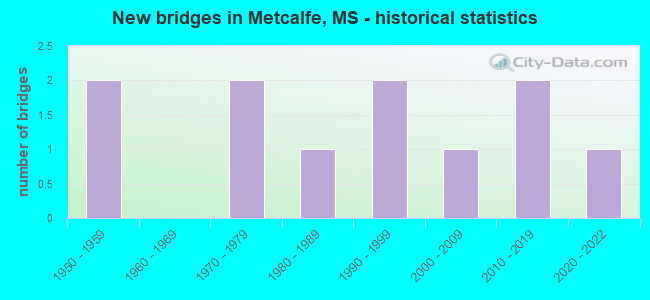
- New bridges - historical statistics
- 21950-1959
- 21970-1979
- 11980-1989
- 21990-1999
- 12000-2009
- 22010-2019
- 12020-2022

- Bridge Condition - Deck
- 50.0%Very good
- 30.0%Satisfactory
- 20.0%Fair

- Bridge Condition - Superstructure
- 50.0%Very good
- 30.0%Good
- 20.0%Satisfactory

- Bridge Condition - Substructure
- 40.0%Very good
- 40.0%Good
- 10.0%Satisfactory
- 10.0%Critical

- Bridge Condition - Channel
- 27.3%Excellent
- 36.4%Very good
- 36.4%Good
Find on map >> Show street view
Structure Number: SA7600000000286, Location: SEC 19 T19N R 7W B (Lat: 33.473147, Lng: -90.971511), Route carried "on" structure: County highway 618, Year Built: 1957, Status: Open, Structure Length: 1.83m (6.00ft), Average Daily Traffic: 250 (year 2020), Truck Traffic: 8%, Average Future Daily Traffic: 375 (year 2040), Design Load: H 15, Features Intersected: CANAL
Minimum Vertical Clearance: 30+ m (98+ ft), Kilometerpoint: 6.598, Lanes on structure: 2, Owner: County Highway Agency, Approaching Roadway Width: 10.4m (34.1ft), Skew: 3 degrees, Material/Design: Concrete, Design/Construction: Slab, Number Of Spans In Main Unit: 3, Length of Maximum Span: 6.1m (20.0ft), Curb-To-Curb Width: 8.6m (28.2ft), Out-to-Out Width: 10.0m (32.8ft)
Condition: Deck: Satisfactory, Superstructure: Good, Substructure: Good, Channel: Very good, Operating Rating: 27.2 metric tons, Method Used To Determine Operating Rating: Load Factor (LF), Inventory Rating: 16.3 metric tons, Method Used To Determine Inventory Rating: Load Factor (LF), Structural Evaluation: Somewhat better than minimum adequacy, Deck Geometry: Equal to present minimum criteria, Waterway Adequacy: Better than present minimum criteria, Approach Roadway Alignment: Equal to present minimum criteria, Bridge Posting: Required (Relationship of Operating Rating to Maximum Legal Load: 30.0 - 39.9% below), Length Of Structure Improvement: 1.83m (6.00ft), Designated Inspection Frequency: Every 24 months, Inspection Date: Febuary 2020, Bridge Improvement Cost: $69,000, Roadway Improvement Cost: $130,000, Total Project Cost: $203,000, Deck Structure Type: Concrete Precast Panels, Wearing Surface/Protective System: Wearing Surface: Bituminous
Find on map >> Show street view
Structure Number: SA7600000000287, Location: SEC 19 T19N R 7W B (Lat: 33.473175, Lng: -90.954253), Route carried "on" structure: County highway 618, Year Built: 1957, Status: Posted for load, Structure Length: 1.83m (6.00ft), Average Daily Traffic: 250 (year 2020), Truck Traffic: 8%, Average Future Daily Traffic: 375 (year 2040), Design Load: H 15, Features Intersected: CANAL
Minimum Vertical Clearance: 30+ m (98+ ft), Kilometerpoint: 8.368, Lanes on structure: 2, Owner: County Highway Agency, Approaching Roadway Width: 10.4m (34.1ft), Material/Design: Concrete, Design/Construction: Slab, Number Of Spans In Main Unit: 3, Length of Maximum Span: 6.1m (20.0ft), Curb-To-Curb Width: 7.4m (24.3ft), Out-to-Out Width: 8.7m (28.5ft)
Condition: Deck: Fair, Superstructure: Good, Substructure: Good, Channel: Good, Operating Rating: 30.2 metric tons, Method Used To Determine Operating Rating: Load Factor (LF), Inventory Rating: 18.1 metric tons, Method Used To Determine Inventory Rating: Load Factor (LF), Structural Evaluation: Somewhat better than minimum adequacy, Deck Geometry: Somewhat better than minimum adequacy, Waterway Adequacy: Better than present minimum criteria, Approach Roadway Alignment: Equal to present desirable criteria, Bridge Posting: Required (Relationship of Operating Rating to Maximum Legal Load: 10.0 - 19.9% below), Length Of Structure Improvement: 1.83m (6.00ft), Designated Inspection Frequency: Every 24 months, Inspection Date: March 2020, Bridge Improvement Cost: $257,000, Roadway Improvement Cost: $130,000, Total Project Cost: $387,000 ( Estimate for 2021), Deck Structure Type: Concrete Cast-file-Place, Wearing Surface/Protective System: Wearing Surface: Bituminous
Find on map >> Show street view
Structure Number: SA7600000000292, Location: SEC 30 T19N R 7W (Lat: 33.473022, Lng: -90.954433), Route carried "on" structure: County highway 544, Year Built: 1995, Status: Open, Structure Length: 1.46m (4.79ft), Average Daily Traffic: 50 (year 2019), Truck Traffic: 8%, Average Future Daily Traffic: 75 (year 2039), Features Intersected: BAYOU, Facility Carried by Structure: PETES DUMP ROAD
Minimum Vertical Clearance: 30+ m (98+ ft), Kilometerpoint: 11.426, Lanes on structure: 1, Owner: County Highway Agency, Approaching Roadway Width: 6.4m (21.0ft), Material/Design: Steel, Number Of Spans In Main Unit: 1, Length of Maximum Span: 14.6m (47.9ft), Curb-To-Curb Width: 7.5m (24.6ft), Out-to-Out Width: 7.7m (25.3ft)
Condition: Deck: Fair, Superstructure: Satisfactory, Substructure: Satisfactory, Channel: Good, Operating Rating: 37.3 metric tons, Method Used To Determine Operating Rating: Load Factor (LF) rating reported by rating factor (RF) method using MS18 loading, Inventory Rating: 22.4 metric tons, Method Used To Determine Inventory Rating: Load Factor (LF) rating reported by rating factor (RF) method using MS18 loading, Structural Evaluation: Equal to present minimum criteria, Deck Geometry: Equal to present minimum criteria, Waterway Adequacy: Equal to present minimum criteria, Approach Roadway Alignment: High priority of corrective action, Length Of Structure Improvement: 2.47m (8.10ft), Designated Inspection Frequency: Every 24 months, Inspection Date: December 2020, Bridge Improvement Cost: $80,000, Roadway Improvement Cost: $130,000, Total Project Cost: $247,000, Deck Structure Type: Other, Wearing Surface/Protective System: Wearing Surface: Other
Find on map >> Show street view
Structure Number: SA7600000000293, Location: SEC 31 T19N R 7W (Lat: 33.458753, Lng: -90.956469), Route carried "on" structure: County highway 544, Year Built: 1972, Status: Closed, Structure Length: 1.74m (5.71ft), Average Daily Traffic: 50 (year 2013), Average Future Daily Traffic: 75 (year 2033), Design Load: HS 20, Features Intersected: CLARK BAYOU, Facility Carried by Structure: PETES DUMP ROAD
Minimum Vertical Clearance: 30+ m (98+ ft), Kilometerpoint: 9.656, Lanes on structure: 2, Owner: County Highway Agency, Approaching Roadway Width: 7.3m (24.0ft), Material/Design: Concrete, Design/Construction: Channel Beam, Number Of Spans In Main Unit: 3, Length of Maximum Span: 5.8m (19.0ft), Curb-To-Curb Width: 7.3m (24.0ft), Out-to-Out Width: 7.6m (24.9ft)
Condition: Deck: Satisfactory, Superstructure: Satisfactory, Substructure: Critical, Channel: Good, Operating Rating: 13.3 metric tons, Method Used To Determine Operating Rating: Load Factor (LF) rating reported by rating factor (RF) method using MS18 loading, Inventory Rating: 7.1 metric tons, Method Used To Determine Inventory Rating: Load Factor (LF) rating reported by rating factor (RF) method using MS18 loading, Deck Geometry: Equal to present minimum criteria, Waterway Adequacy: Equal to present minimum criteria, Approach Roadway Alignment: High priority of corrective action, Bridge Posting: Required (Relationship of Operating Rating to Maximum Legal Load: > 39.9% below), Length Of Structure Improvement: 1.74m (5.71ft), Designated Inspection Frequency: Every 12 months, Inspection Date: October 2021, Bridge Improvement Cost: $50,000, Roadway Improvement Cost: $130,000, Total Project Cost: $212,000, Deck Structure Type: Concrete Precast Panels
Find on map >> Show street view
Structure Number: SA7600000000307, Location: SEC 14 T19N R 8W B (Lat: 33.501706, Lng: -90.995894), Route carried "on" structure: County highway 2005, Year Built: 1997, Status: Open, Structure Length: 5.14m (16.86ft), Average Daily Traffic: 740 (year 2020), Truck Traffic: 8%, Average Future Daily Traffic: 1,110 (year 2040), Design Load: HS 20, Features Intersected: DEER CREEK, Facility Carried by Structure: PRISCILLA ROAD
Minimum Vertical Clearance: 30+ m (98+ ft), Kilometerpoint: 10.138, Lanes on structure: 2, Owner: County Highway Agency, Approaching Roadway Width: 6.7m (22.0ft), Material/Design: Prestressed concrete, Design/Construction: Stringer/Multi-beam, Number Of Spans In Main Unit: 7, Length of Maximum Span: 9.4m (30.8ft), Curb-To-Curb Width: 8.5m (27.9ft), Out-to-Out Width: 9.4m (30.8ft)
Condition: Deck: Very good, Superstructure: Very good, Substructure: Very good, Channel: Excellent, Operating Rating: 78.7 metric tons, Method Used To Determine Operating Rating: Load Factor (LF) rating reported by rating factor (RF) method using MS18 loading, Inventory Rating: 30.1 metric tons, Method Used To Determine Inventory Rating: Load Factor (LF) rating reported by rating factor (RF) method using MS18 loading, Structural Evaluation: Better than present minimum criteria, Deck Geometry: Somewhat better than minimum adequacy, Waterway Adequacy: Equal to present desirable criteria, Approach Roadway Alignment: High priority of corrective action, Designated Inspection Frequency: Every 24 months, Inspection Date: April 2020, Deck Structure Type: Concrete Cast-file-Place
Find on map >> Show street view
Structure Number: SA7600000000311, Location: SEC 23 T19N R 8W (Lat: 33.478364, Lng: -91.003572), Route carried "on" structure: County highway 599, Year Built: 1983, Status: Open, Structure Length: 3.47m (11.38ft), Average Daily Traffic: 2,000 (year 2020), Truck Traffic: 8%, Average Future Daily Traffic: 3,000 (year 2020), Design Load: H 15, Features Intersected: DEER CREEK, Facility Carried by Structure: AIRPORT-GATE NO 2
Minimum Vertical Clearance: 30+ m (98+ ft), Kilometerpoint: 0.160, Lanes on structure: 2, Owner: County Highway Agency, Approaching Roadway Width: 9.1m (29.9ft), Material/Design: Concrete, Design/Construction: Channel Beam, Number Of Spans In Main Unit: 6, Length of Maximum Span: 5.8m (19.0ft), Curb-To-Curb Width: 8.1m (26.6ft), Out-to-Out Width: 8.5m (27.9ft)
Condition: Deck: Very good, Superstructure: Very good, Substructure: Good, Channel: Very good, Operating Rating: 40.6 metric tons, Method Used To Determine Operating Rating: Load Factor (LF), Inventory Rating: 24.3 metric tons, Method Used To Determine Inventory Rating: Load Factor (LF), Structural Evaluation: Equal to present minimum criteria, Deck Geometry: Meets minimum limits, Waterway Adequacy: Better than present minimum criteria, Approach Roadway Alignment: Equal to present minimum criteria, Length Of Structure Improvement: 3.47m (11.38ft), Designated Inspection Frequency: Every 24 months, Inspection Date: July 2020, Bridge Improvement Cost: $112,000, Roadway Improvement Cost: $200,000, Total Project Cost: $370,000 ( Estimate for 2020), Deck Structure Type: Concrete Precast Panels, Wearing Surface/Protective System: Wearing Surface: Bituminous
Find on map >> Show street view
Structure Number: SA7600000000312, Location: SEC 26 T19N R 8W B (Lat: 33.458797, Lng: -91.004789), Route carried "on" structure: City street 618, Year Built: 1979, Status: Open, Structure Length: 6.10m (20.01ft), Average Daily Traffic: 250 (year 2021), Truck Traffic: 8%, Average Future Daily Traffic: 375 (year 2041), Design Load: HS 20, Features Intersected: DEER CREEK
Minimum Vertical Clearance: 30+ m (98+ ft), Kilometerpoint: 3.057, Lanes on structure: 2, Owner: County Highway Agency, Approaching Roadway Width: 6.7m (22.0ft), Material/Design: Prestressed concrete, Design/Construction: Stringer/Multi-beam, Number Of Spans In Main Unit: 5, Length of Maximum Span: 12.2m (40.0ft), Curb-To-Curb Width: 8.5m (27.9ft), Out-to-Out Width: 8.8m (28.9ft)
Condition: Deck: Satisfactory, Superstructure: Good, Substructure: Good, Channel: Good, Operating Rating: 74.5 metric tons, Method Used To Determine Operating Rating: Load Factor (LF) rating reported by rating factor (RF) method using MS18 loading, Inventory Rating: 34.0 metric tons, Method Used To Determine Inventory Rating: Load Factor (LF) rating reported by rating factor (RF) method using MS18 loading, Structural Evaluation: Better than present minimum criteria, Deck Geometry: Equal to present minimum criteria, Waterway Adequacy: Equal to present desirable criteria, Approach Roadway Alignment: Somewhat better than minimum adequacy, Designated Inspection Frequency: Every 24 months, Inspection Date: August 2020, Deck Structure Type: Concrete Precast Panels, Wearing Surface/Protective System: Wearing Surface: Monolithic Concrete
Find on map >> Show street view
Structure Number: SA7600000000317, Location: SEC 34 T19N R 8W B (Lat: 33.454919, Lng: -91.010419), Route carried "on" structure: City street 618, Year Built: 2003, Status: Open, Structure Length: 0.97m (3.18ft), Average Daily Traffic: 1,950 (year 2020), Truck Traffic: 8%, Average Future Daily Traffic: 2,940 (year 2041), Design Load: HS 20, Features Intersected: HORSESHOE BAYOU
Minimum Vertical Clearance: 30+ m (98+ ft), Kilometerpoint: 2.253, Lanes on structure: 2, Owner: County Highway Agency, Approaching Roadway Width: 9.1m (29.9ft), Skew: 4 degrees, Material/Design: Concrete, Design/Construction: Culvert, Number Of Spans In Main Unit: 1, Length of Maximum Span: 6.1m (20.0ft), Curb-To-Curb Width: 9.1m (29.9ft), Out-to-Out Width: 9.1m (29.9ft)
Condition: Channel: Excellent, Culverts: Fair, Structural Evaluation: Somewhat better than minimum adequacy, Deck Geometry: Somewhat better than minimum adequacy, Waterway Adequacy: Superior to present desirable criteria, Approach Roadway Alignment: Equal to present desirable criteria, Designated Inspection Frequency: Every 12 months, Inspection Date: May 2021, Deck Structure Type: Concrete Cast-file-Place, Wearing Surface/Protective System: Wearing Surface: Bituminous
Find on map >> Show street view
Structure Number: SA760000000A244, Location: SEC 7 T18N R 8W (Lat: 33.443894, Lng: -90.982925), Route carried "on" structure: County highway 544, Year Built: 2020, Status: Open, Structure Length: 3.41m (11.19ft), Average Daily Traffic: 50 (year 2020), Truck Traffic: 8%, Average Future Daily Traffic: 75 (year 2040), Design Load: HL 93, Features Intersected: DEER CREEK, Facility Carried by Structure: PETES DUMP ROAD
Minimum Vertical Clearance: 30+ m (98+ ft), Kilometerpoint: 6.759, Lanes on structure: 2, Owner: County Highway Agency, Approaching Roadway Width: 8.5m (27.9ft), Material/Design: Concrete, Design/Construction: Channel Beam, Number Of Spans In Main Unit: 4, Length of Maximum Span: 9.4m (30.8ft), Curb-To-Curb Width: 9.1m (29.9ft), Out-to-Out Width: 10.0m (32.8ft)
Condition: Deck: Very good, Superstructure: Very good, Substructure: Very good, Channel: Very good, Operating Rating: 43.7 metric tons, Method Used To Determine Operating Rating: Load and Resistance Factor Rating (LRFR) rating reported by rating factor(RF) method using HL-93 loadings, Inventory Rating: 33.7 metric tons, Method Used To Determine Inventory Rating: Load and Resistance Factor Rating (LRFR) rating reported by rating factor(RF) method using HL-93 loadings, Structural Evaluation: Equal to present desirable criteria, Deck Geometry: Better than present minimum criteria, Waterway Adequacy: Superior to present desirable criteria, Approach Roadway Alignment: Equal to present minimum criteria, Designated Inspection Frequency: Every 24 months, Inspection Date: July 2020, Deck Structure Type: Concrete Precast Panels, Wearing Surface/Protective System: Wearing Surface: Monolithic Concrete
Find on map >> Show street view
Structure Number: SA760000000A245, Location: SEC 8 T18N R 8W (Lat: 33.443597, Lng: -91.002083), Route carried "on" structure: City street 544, Year Built: 2016, Status: Open, Structure Length: 3.41m (11.19ft), Average Daily Traffic: 1,875 (year 2020), Truck Traffic: 8%, Average Future Daily Traffic: 2,000 (year 2040), Design Load: HL 93, Features Intersected: HORSESHOE BAYOU, Facility Carried by Structure: ABIDE ROAD
Minimum Vertical Clearance: 30+ m (98+ ft), Kilometerpoint: 4988.000, Lanes on structure: 2, Owner: County Highway Agency, Approaching Roadway Width: 7.3m (24.0ft), Material/Design: Concrete, Design/Construction: Channel Beam, Number Of Spans In Main Unit: 4, Length of Maximum Span: 9.4m (30.8ft), Curb-To-Curb Width: 9.1m (29.9ft), Out-to-Out Width: 9.4m (30.8ft)
Condition: Deck: Very good, Superstructure: Very good, Substructure: Very good, Channel: Very good, Operating Rating: 43.7 metric tons, Method Used To Determine Operating Rating: Load and Resistance Factor Rating (LRFR) rating reported by rating factor(RF) method using HL-93 loadings, Inventory Rating: 33.7 metric tons, Method Used To Determine Inventory Rating: Load and Resistance Factor Rating (LRFR) rating reported by rating factor(RF) method using HL-93 loadings, Structural Evaluation: Equal to present desirable criteria, Deck Geometry: Somewhat better than minimum adequacy, Waterway Adequacy: Equal to present desirable criteria, Approach Roadway Alignment: Equal to present desirable criteria, Designated Inspection Frequency: Every 24 months, Inspection Date: November 2020, Deck Structure Type: Concrete Precast Panels, Wearing Surface/Protective System: Wearing Surface: Monolithic Concrete
Find on map >> Show street view
Structure Number: SA760000000A308, Location: SEC 15 T19N R 8W (Lat: 33.487561, Lng: -91.023992), Route carried "on" structure: County highway 596, Year Built: 2013, Status: Open, Structure Length: 2.10m (6.89ft), Average Daily Traffic: 50 (year 2018), Average Future Daily Traffic: 75 (year 2038), Design Load: HL 93, Features Intersected: CANAL, Facility Carried by Structure: IRELAND ROAD
Minimum Vertical Clearance: 30+ m (98+ ft), Kilometerpoint: 2.735, Lanes on structure: 2, Owner: County Highway Agency, Approaching Roadway Width: 6.1m (20.0ft), Material/Design: Concrete, Design/Construction: Channel Beam, Number Of Spans In Main Unit: 3, Length of Maximum Span: 9.4m (30.8ft), Curb-To-Curb Width: 9.1m (29.9ft), Out-to-Out Width: 9.9m (32.5ft)
Condition: Deck: Very good, Superstructure: Very good, Substructure: Very good, Channel: Excellent, Operating Rating: 43.7 metric tons, Method Used To Determine Operating Rating: Load and Resistance Factor Rating (LRFR) rating reported by rating factor(RF) method using HL-93 loadings, Inventory Rating: 33.7 metric tons, Method Used To Determine Inventory Rating: Load and Resistance Factor Rating (LRFR) rating reported by rating factor(RF) method using HL-93 loadings, Structural Evaluation: Equal to present desirable criteria, Deck Geometry: Better than present minimum criteria, Waterway Adequacy: Superior to present desirable criteria, Approach Roadway Alignment: Equal to present desirable criteria, Designated Inspection Frequency: Every 24 months, Inspection Date: April 2020, Bridge Improvement Cost: $250,000, Roadway Improvement Cost: $100,000, Total Project Cost: $350,000, Deck Structure Type: Concrete Precast Panels, Wearing Surface/Protective System: Wearing Surface: Monolithic Concrete