Bridge Statistics for Merritt Island, Florida (FL)
Condition, Traffic, Stress, Structural Evaluation, Project Costs
- National Bridge Inventory (NBI) Statistics
- 38Number of bridges
- 1,834ft / 559mTotal length
- $27,362,000Total costs
- 628,776Total average daily traffic
- 57,452Total average daily truck traffic
- National Bridge Inventory (NBI) Registered Bridges for Merritt Island
- No street view available for this location
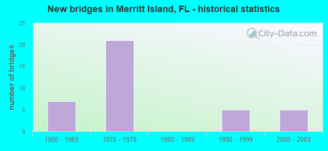
- New bridges - historical statistics
- 71960-1969
- 211970-1979
- 51990-1999
- 52000-2009
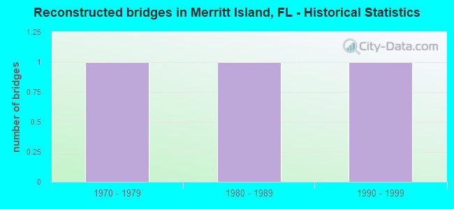
- Reconstructed bridges - Historical Statistics
- 11970-1979
- 11980-1989
- 11990-1999
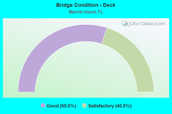
- Bridge Condition - Deck
- 60.0%Good
- 40.0%Satisfactory
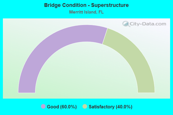
- Bridge Condition - Superstructure
- 60.0%Good
- 40.0%Satisfactory
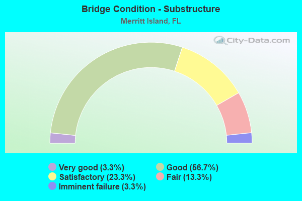
- Bridge Condition - Substructure
- 3.3%Very good
- 56.7%Good
- 23.3%Satisfactory
- 13.3%Fair
- 3.3%Imminent failure
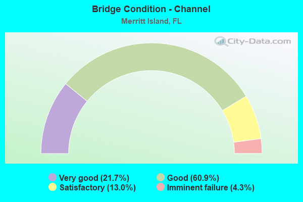
- Bridge Condition - Channel
- 21.7%Very good
- 60.9%Good
- 13.0%Satisfactory
- 4.3%Imminent failure
Find on map >> Show street view
Structure Number: 70011, Location: 0.1 MILE W OF CR-78A (Lat: 26.747222, Lng: -81.513019), Route carried "on" structure: County highway 78, Year Built: 1961, Status: Posted for load, Structure Length: 4.05m (13.29ft), Average Daily Traffic: 2,580 (year 2021), Truck Traffic: 10%, Average Future Daily Traffic: 3,096 (year 2041), Design Load: H 15, Features Intersected: JACKS BRANCH
Minimum Vertical Clearance: 30+ m (98+ ft), Kilometerpoint: 7.406, Lanes on structure: 2, Owner: County Highway Agency, Approaching Roadway Width: 6.2m (20.3ft), Skew: 3 degrees, Material/Design: Concrete, Design/Construction: Slab, Number Of Spans In Main Unit: 5, Length of Maximum Span: 8.2m (26.9ft), Curb or Sidewalk Widths: Left: 0.6m (2.0ft), Right: 0.6m (2.0ft), Curb-To-Curb Width: 7.3m (24.0ft), Out-to-Out Width: 9.2m (30.2ft)
Condition: Deck: Satisfactory, Superstructure: Satisfactory, Substructure: Satisfactory, Channel: Good, Operating Rating: 37.6 metric tons, Method Used To Determine Operating Rating: Load Factor (LF), Inventory Rating: 22.6 metric tons, Method Used To Determine Inventory Rating: Load Factor (LF), Structural Evaluation: Equal to present minimum criteria, Deck Geometry: High priority of replacement, Waterway Adequacy: Equal to present minimum criteria, Approach Roadway Alignment: Equal to present desirable criteria, Bridge Posting: Required (Relationship of Operating Rating to Maximum Legal Load: 10.0 - 19.9% below), Designated Inspection Frequency: Every 24 months, Underwater Inspection Frequency: Every 24 months, Other Special Inspection Frequency: Every 12 months, Inspection Date: June 2021, Underwater Inspection Date: May 2021, Other Special Inspection Date: June 2021, Deck Structure Type: Concrete Cast-file-Place
Find on map >> Show street view
Structure Number: 700017, Location: SR-528 WB over SR-3 (Lat: 28.405369, Lng: -80.705781), Route carried "on" structure: State highway 528, Year Built: 1971, Status: Open, Structure Length: 5.33m (17.49ft), Average Daily Traffic: 15,250 (year 2020), Truck Traffic: 5%, Average Future Daily Traffic: 26,459 (year 2042), Design Load: HS 20, Features Intersected: SR-3
Minimum Vertical Clearance: 30+ m (98+ ft), Kilometerpoint: 13.364, Lanes on structure: 2, Lanes under structure: 7, Base Highway Network: Yes, Owner: State Highway Agency, Approaching Roadway Width: 11.6m (38.1ft), Material/Design: Prestressed concrete, Design/Construction: Stringer/Multi-beam, Number Of Spans In Main Unit: 3, Length of Maximum Span: 30.2m (99.1ft), Curb-To-Curb Width: 9.8m (32.2ft), Out-to-Out Width: 10.7m (35.1ft)
Condition: Deck: Good, Superstructure: Good, Substructure: Good, Operating Rating: 58.1 metric tons, Method Used To Determine Operating Rating: Load Factor (LF), Inventory Rating: 34.5 metric tons, Method Used To Determine Inventory Rating: Load Factor (LF), Structural Evaluation: Better than present minimum criteria, Deck Geometry: High priority of replacement, Underclear: High priority of corrective action, Approach Roadway Alignment: Equal to present desirable criteria, Designated Inspection Frequency: Every 24 months, Inspection Date: March 2020, Deck Structure Type: Concrete Cast-file-Place
Find on map >> Show street view
Structure Number: 700026, Location: 2.55 Miles East of SR-3 (Lat: 28.405214, Lng: -80.663622), Route carried "on" structure: State highway 528, Year Built: 1963, Status: Open, Structure Length: 2.71m (8.89ft), Average Daily Traffic: 13,000 (year 2020), Truck Traffic: 5%, Average Future Daily Traffic: 22,555 (year 2042), Design Load: HS 20+Mod, Features Intersected: Banana River Drive
Minimum Vertical Clearance: 30+ m (98+ ft), Kilometerpoint: 17.497, Lanes on structure: 2, Lanes under structure: 2, Base Highway Network: Yes, Owner: State Highway Agency, Approaching Roadway Width: 11.2m (36.7ft), Material/Design: Prestressed concrete, Design/Construction: Stringer/Multi-beam, Number Of Spans In Main Unit: 1, Length of Maximum Span: 26.5m (86.9ft), Curb-To-Curb Width: 8.6m (28.2ft), Out-to-Out Width: 10.4m (34.1ft)
Condition: Deck: Good, Superstructure: Good, Substructure: Good, Operating Rating: 74.4 metric tons, Method Used To Determine Operating Rating: Load Factor (LF), Inventory Rating: 45.8 metric tons, Method Used To Determine Inventory Rating: Load Factor (LF), Structural Evaluation: Better than present minimum criteria, Deck Geometry: High priority of replacement, Underclear: Meets minimum limits, Approach Roadway Alignment: Equal to present desirable criteria, Length Of Structure Improvement: 3.00m (9.84ft), Designated Inspection Frequency: Every 24 months, Inspection Date: January 2022, Bridge Improvement Cost: $33,000, Total Project Cost: $203,000, Deck Structure Type: Concrete Cast-file-Place
Find on map >> Show street view
Structure Number: 700027, Location: 2.85 Miles East of SR-3 (Lat: 28.405222, Lng: -80.658469), Route carried "on" structure: State highway 528, Year Built: 1963, Status: Open, Structure Length: 8.53m (27.99ft), Average Daily Traffic: 13,000 (year 2020), Truck Traffic: 5%, Average Future Daily Traffic: 22,555 (year 2042), Design Load: HS 20+Mod, Features Intersected: Banana River Relief
Minimum Vertical Clearance: 30+ m (98+ ft), Kilometerpoint: 17.984, Lanes on structure: 2, Base Highway Network: Yes, Owner: State Highway Agency, Approaching Roadway Width: 9.4m (30.8ft), Material/Design: Prestressed concrete, Design/Construction: Stringer/Multi-beam, Number Of Spans In Main Unit: 7, Length of Maximum Span: 12.2m (40.0ft), Curb-To-Curb Width: 9.4m (30.8ft), Out-to-Out Width: 10.3m (33.8ft)
Condition: Deck: Satisfactory, Superstructure: Good, Substructure: Fair, Channel: Good, Operating Rating: 75.3 metric tons, Method Used To Determine Operating Rating: Load Factor (LF), Inventory Rating: 47.6 metric tons, Method Used To Determine Inventory Rating: Load Factor (LF), Structural Evaluation: Somewhat better than minimum adequacy, Deck Geometry: Meets minimum limits, Waterway Adequacy: Equal to present desirable criteria, Approach Roadway Alignment: Equal to present desirable criteria, Length Of Structure Improvement: 8.53m (27.99ft), Designated Inspection Frequency: Every 24 months, Underwater Inspection Frequency: Every 24 months, Inspection Date: January 2022, Underwater Inspection Date: January 2021, Bridge Improvement Cost: $60,000, Total Project Cost: $752,000, Deck Structure Type: Concrete Cast-file-Place
Find on map >> Show street view
Structure Number: 700028, Location: 0.7MI W OF SR-401 (Lat: 28.405256, Lng: -80.646183), Route carried "on" structure: State highway 528, Year Built: 1963, Status: Open, Structure Length: 33.98m (111.48ft), Average Daily Traffic: 13,000 (year 2020), Truck Traffic: 5%, Average Future Daily Traffic: 22,555 (year 2042), Design Load: HS 20+Mod, Features Intersected: Banana River
Minimum Vertical Clearance: 30+ m (98+ ft), Kilometerpoint: 19.058, Lanes on structure: 2, Base Highway Network: Yes, Owner: State Highway Agency, Approaching Roadway Width: 13.4m (44.0ft), Navigation Control: Yes ( Vertical Clearance: 11.1m (36.4ft), Horizontal Clearance: 18.2m (59.7ft)), Material/Design: Prestressed concrete, Design/Construction: Stringer/Multi-beam, Number Of Spans In Main Unit: 19, Length of Maximum Span: 26.5m (86.9ft), Curb-To-Curb Width: 8.6m (28.2ft), Out-to-Out Width: 10.5m (34.4ft)
Condition: Deck: Satisfactory, Superstructure: Satisfactory, Substructure: Fair, Channel: Good, Operating Rating: 65.1 metric tons, Method Used To Determine Operating Rating: Load Factor (LF), Inventory Rating: 39.1 metric tons, Method Used To Determine Inventory Rating: Load Factor (LF), Structural Evaluation: Somewhat better than minimum adequacy, Deck Geometry: High priority of corrective action, Waterway Adequacy: Superior to present desirable criteria, Approach Roadway Alignment: Equal to present desirable criteria, Length Of Structure Improvement: 33.92m (111.29ft), Designated Inspection Frequency: Every 24 months, Underwater Inspection Frequency: Every 24 months, Inspection Date: July 2020, Underwater Inspection Date: July 2020, Bridge Improvement Cost: $239,000, Total Project Cost: $752,000, Deck Structure Type: Concrete Cast-file-Place
Find on map >> Show street view
Structure Number: 700072, Location: SR-3 SB over Barge Canal (Lat: 28.407714, Lng: -80.705983), Route carried "on" structure: State highway 3, Year Built: 1961, Year Reconstructed: 1998, Status: Open, Structure Length: 9.08m (29.79ft), Average Daily Traffic: 14,000 (year 2021), Truck Traffic: 3%, Average Future Daily Traffic: 24,290 (year 2042), Design Load: H 20, Features Intersected: Barge Canal
Minimum Vertical Clearance: 5.64m (18.50ft), Kilometerpoint: 5.626, Lanes on structure: 2, Owner: State Highway Agency, Approaching Roadway Width: 7.4m (24.3ft), Navigation Control: Yes ( Vertical Clearance: 6.5m (21.3ft), Horizontal Clearance: 27.4m (89.9ft)), Material/Design: Steel, Design/Construction: Movable - Bascule, Number Of Spans In Main Unit: 1, Number Of Approach Spans: 4, Length of Maximum Span: 42.7m (140.1ft), Curb or Sidewalk Widths: Left: 1.5m (4.9ft), Right: 0.0m, Curb-To-Curb Width: 8.7m (28.5ft), Out-to-Out Width: 11.3m (37.1ft)
Condition: Deck: Satisfactory, Superstructure: Satisfactory, Substructure: Good, Channel: Good, Operating Rating: 39.6 metric tons, Method Used To Determine Operating Rating: Load Factor (LF), Inventory Rating: 23.7 metric tons, Method Used To Determine Inventory Rating: Load Factor (LF), Structural Evaluation: Somewhat better than minimum adequacy, Deck Geometry: High priority of corrective action, Waterway Adequacy: Equal to present desirable criteria, Approach Roadway Alignment: Equal to present desirable criteria, Length Of Structure Improvement: 9.08m (29.79ft), Designated Inspection Frequency: Every 24 months, Critical Feature Inspection Frequency: Every 24 months, Underwater Inspection Frequency: Every 24 months, Other Special Inspection Frequency: Every 12 months, Inspection Date: June 2020, Critical Feature Inspection Date: June 2020, Underwater Inspection Date: June 2020, Other Special Inspection Date: June 2021, Bridge Improvement Cost: $605,000, Total Project Cost: $740,000, Deck Structure Type: Open Grating
Find on map >> Show street view
Structure Number: 700077, Location: SR-404 WB - Indian River (Lat: 28.206442, Lng: -80.650197), Route carried "on" structure: State highway 404, Year Built: 1971, Status: Open, Structure Length: 69.56m (228.22ft), Average Daily Traffic: 26,250 (year 2020), Truck Traffic: 18%, Average Future Daily Traffic: 45,544 (year 2042), Design Load: HS 20, Features Intersected: Indian River
Minimum Vertical Clearance: 30+ m (98+ ft), Kilometerpoint: 1.833, Lanes on structure: 2, Base Highway Network: Yes, Owner: State Highway Agency, Approaching Roadway Width: 10.8m (35.4ft), Navigation Control: Yes ( Vertical Clearance: 19.5m (64.0ft), Horizontal Clearance: 27.4m (89.9ft)), Material/Design: Prestressed concrete, Design/Construction: Stringer/Multi-beam, Number Of Spans In Main Unit: 29, Length of Maximum Span: 35.4m (116.1ft), Curb-To-Curb Width: 10.2m (33.5ft), Out-to-Out Width: 10.7m (35.1ft)
Condition: Deck: Satisfactory, Superstructure: Satisfactory, Substructure: Satisfactory, Channel: Good, Operating Rating: 54.0 metric tons, Method Used To Determine Operating Rating: Load Factor (LF), Inventory Rating: 32.4 metric tons, Method Used To Determine Inventory Rating: Load Factor (LF), Structural Evaluation: Equal to present minimum criteria, Deck Geometry: Somewhat better than minimum adequacy, Waterway Adequacy: Equal to present desirable criteria, Approach Roadway Alignment: Equal to present desirable criteria, Length Of Structure Improvement: 64.99m (213.22ft), Designated Inspection Frequency: Every 24 months, Underwater Inspection Frequency: Every 24 months, Inspection Date: April 2020, Underwater Inspection Date: May 2020, Bridge Improvement Cost: $568,000, Total Project Cost: $2,725,000, Deck Structure Type: Concrete Cast-file-Place, Wearing Surface/Protective System: Wearing Surface: Monolithic Concrete
Find on map >> Show street view
Structure Number: 700078, Location: SR-404 WB-Indian River (Lat: 28.207350, Lng: -80.643836), Route carried "on" structure: State highway 404, Year Built: 1971, Status: Open, Structure Length: 5.30m (17.39ft), Average Daily Traffic: 26,250 (year 2020), Truck Traffic: 18%, Average Future Daily Traffic: 45,544 (year 2042), Design Load: HS 20, Features Intersected: Indian River Relief East
Minimum Vertical Clearance: 30+ m (98+ ft), Kilometerpoint: 2.786, Lanes on structure: 2, Owner: State Highway Agency, Approaching Roadway Width: 10.5m (34.4ft), Material/Design: Prestressed concrete, Design/Construction: Stringer/Multi-beam, Number Of Spans In Main Unit: 4, Length of Maximum Span: 13.1m (43.0ft), Curb-To-Curb Width: 12.2m (40.0ft), Out-to-Out Width: 12.8m (42.0ft)
Condition: Deck: Good, Superstructure: Good, Substructure: Satisfactory, Channel: Very good, Operating Rating: 55.2 metric tons, Method Used To Determine Operating Rating: Load Factor (LF), Inventory Rating: 33.9 metric tons, Method Used To Determine Inventory Rating: Load Factor (LF), Structural Evaluation: Equal to present minimum criteria, Deck Geometry: Better than present minimum criteria, Waterway Adequacy: Equal to present desirable criteria, Approach Roadway Alignment: Equal to present desirable criteria, Length Of Structure Improvement: 5.24m (17.19ft), Designated Inspection Frequency: Every 24 months, Underwater Inspection Frequency: Every 24 months, Inspection Date: November 2021, Underwater Inspection Date: November 2021, Bridge Improvement Cost: $43,000, Total Project Cost: $2,725,000, Deck Structure Type: Concrete Cast-file-Place, Wearing Surface/Protective System: Wearing Surface: Monolithic Concrete
Find on map >> Show street view
Structure Number: 700079, Location: SR-404 WB over CR-3 (Lat: 28.208211, Lng: -80.638258), Route carried "on" structure: State highway 404, Year Built: 1971, Status: Open, Structure Length: 5.64m (18.50ft), Average Daily Traffic: 26,250 (year 2020), Truck Traffic: 18%, Average Future Daily Traffic: 45,544 (year 2042), Design Load: HS 20, Features Intersected: CR-3
Minimum Vertical Clearance: 30+ m (98+ ft), Kilometerpoint: 3.344, Lanes on structure: 2, Lanes under structure: 4, Owner: State Highway Agency, Approaching Roadway Width: 11.0m (36.1ft), Skew: 1 degrees, Material/Design: Prestressed concrete, Design/Construction: Stringer/Multi-beam, Number Of Spans In Main Unit: 3, Length of Maximum Span: 31.4m (103.0ft), Curb-To-Curb Width: 12.2m (40.0ft), Out-to-Out Width: 12.9m (42.3ft)
Condition: Deck: Good, Superstructure: Good, Substructure: Good, Operating Rating: 51.6 metric tons, Method Used To Determine Operating Rating: Load Factor (LF), Inventory Rating: 32.4 metric tons, Method Used To Determine Inventory Rating: Load Factor (LF), Structural Evaluation: Better than present minimum criteria, Deck Geometry: Better than present minimum criteria, Underclear: Better than present minimum criteria, Approach Roadway Alignment: Equal to present desirable criteria, Length Of Structure Improvement: 5.58m (18.31ft), Designated Inspection Frequency: Every 24 months, Inspection Date: September 2021, Bridge Improvement Cost: $45,000, Total Project Cost: $2,725,000, Deck Structure Type: Concrete Cast-file-Place, Wearing Surface/Protective System: Wearing Surface: Monolithic Concrete
Find on map >> Show street view
Structure Number: 70008, Location: SR-404 WB-Banana River (Lat: 28.209136, Lng: -80.633981), Route carried "on" structure: State highway 404, Year Built: 1971, Status: Open, Structure Length: 9.23m (30.28ft), Average Daily Traffic: 26,500 (year 2020), Truck Traffic: 12%, Average Future Daily Traffic: 45,978 (year 2042), Design Load: HS 20, Features Intersected: Banana River Relief West
Minimum Vertical Clearance: 30+ m (98+ ft), Kilometerpoint: 3.759, Lanes on structure: 2, Owner: State Highway Agency, Approaching Roadway Width: 10.9m (35.8ft), Material/Design: Prestressed concrete, Design/Construction: Stringer/Multi-beam, Number Of Spans In Main Unit: 7, Length of Maximum Span: 13.1m (43.0ft), Curb-To-Curb Width: 12.2m (40.0ft), Out-to-Out Width: 12.8m (42.0ft)
Condition: Deck: Good, Superstructure: Good, Substructure: Satisfactory, Channel: Very good, Operating Rating: 55.3 metric tons, Method Used To Determine Operating Rating: Load Factor (LF), Inventory Rating: 34.0 metric tons, Method Used To Determine Inventory Rating: Load Factor (LF), Structural Evaluation: Equal to present minimum criteria, Deck Geometry: Better than present minimum criteria, Waterway Adequacy: Better than present minimum criteria, Approach Roadway Alignment: Equal to present desirable criteria, Length Of Structure Improvement: 9.17m (30.09ft), Designated Inspection Frequency: Every 24 months, Underwater Inspection Frequency: Every 24 months, Inspection Date: November 2021, Underwater Inspection Date: November 2021, Bridge Improvement Cost: $75,000, Total Project Cost: $2,725,000, Deck Structure Type: Concrete Cast-file-Place, Wearing Surface/Protective System: Wearing Surface: Monolithic Concrete
Find on map >> Show street view
Structure Number: 70011, Location: SR-528 WB - Indian River (Lat: 28.402222, Lng: -80.738056), Route carried "on" structure: State highway 528, Year Built: 1970, Status: Open, Structure Length: 70.20m (230.31ft), Average Daily Traffic: 21,579 (year 2020), Truck Traffic: 8%, Average Future Daily Traffic: 37,439 (year 2042), Design Load: HS 20, Features Intersected: Indian River
Minimum Vertical Clearance: 30+ m (98+ ft), Kilometerpoint: 10.179, Lanes on structure: 2, Base Highway Network: Yes, Owner: State Highway Agency, Approaching Roadway Width: 10.6m (34.8ft), Navigation Control: Yes ( Vertical Clearance: 19.8m (65.0ft), Horizontal Clearance: 27.4m (89.9ft)), Material/Design: Steel continuous, Design/Construction: Stringer/Multi-beam, Number Of Spans In Main Unit: 3, Number Of Approach Spans: 22, Length of Maximum Span: 42.7m (140.1ft), Curb-To-Curb Width: 9.6m (31.5ft), Out-to-Out Width: 10.7m (35.1ft)
Condition: Deck: Satisfactory, Superstructure: Satisfactory, Substructure: Fair, Channel: Good, Operating Rating: 50.7 metric tons, Method Used To Determine Operating Rating: Load Factor (LF), Inventory Rating: 30.4 metric tons, Method Used To Determine Inventory Rating: Load Factor (LF), Structural Evaluation: Somewhat better than minimum adequacy, Deck Geometry: Meets minimum limits, Waterway Adequacy: Equal to present desirable criteria, Approach Roadway Alignment: Equal to present desirable criteria, Designated Inspection Frequency: Every 24 months, Underwater Inspection Frequency: Every 24 months, Inspection Date: May 2020, Underwater Inspection Date: May 2020, Deck Structure Type: Concrete Cast-file-Place
Find on map >> Show street view
Structure Number: 700111, Location: SR-528 EB over SR-3 (Lat: 28.405194, Lng: -80.705764), Route carried "on" structure: State highway 528, Year Built: 1970, Status: Open, Structure Length: 5.33m (17.49ft), Average Daily Traffic: 15,250 (year 2020), Truck Traffic: 5%, Average Future Daily Traffic: 26,459 (year 2042), Design Load: HS 20, Features Intersected: SR-3
Minimum Vertical Clearance: 30+ m (98+ ft), Kilometerpoint: 13.364, Lanes on structure: 2, Lanes under structure: 7, Base Highway Network: Yes, Owner: State Highway Agency, Approaching Roadway Width: 11.6m (38.1ft), Material/Design: Prestressed concrete, Design/Construction: Stringer/Multi-beam, Number Of Spans In Main Unit: 3, Length of Maximum Span: 30.2m (99.1ft), Curb-To-Curb Width: 10.1m (33.1ft), Out-to-Out Width: 10.7m (35.1ft)
Condition: Deck: Good, Superstructure: Good, Substructure: Good, Operating Rating: 58.1 metric tons, Method Used To Determine Operating Rating: Load Factor (LF), Inventory Rating: 34.5 metric tons, Method Used To Determine Inventory Rating: Load Factor (LF), Structural Evaluation: Better than present minimum criteria, Deck Geometry: High priority of corrective action, Underclear: High priority of corrective action, Approach Roadway Alignment: Equal to present desirable criteria, Designated Inspection Frequency: Every 24 months, Inspection Date: March 2020, Deck Structure Type: Concrete Cast-file-Place
Find on map >> Show street view
Structure Number: 700113, Location: 2.55 Miles East of SR-3 (Lat: 28.405036, Lng: -80.663636), Route carried "on" structure: State highway 528, Year Built: 1970, Status: Open, Structure Length: 2.71m (8.89ft), Average Daily Traffic: 13,000 (year 2020), Truck Traffic: 5%, Average Future Daily Traffic: 22,555 (year 2042), Design Load: HS 20, Features Intersected: Banana River Drive
Minimum Vertical Clearance: 30+ m (98+ ft), Kilometerpoint: 17.497, Lanes on structure: 2, Lanes under structure: 2, Base Highway Network: Yes, Owner: State Highway Agency, Approaching Roadway Width: 11.0m (36.1ft), Skew: 1 degrees, Material/Design: Prestressed concrete, Design/Construction: Stringer/Multi-beam, Number Of Spans In Main Unit: 1, Length of Maximum Span: 26.5m (86.9ft), Curb-To-Curb Width: 10.1m (33.1ft), Out-to-Out Width: 10.7m (35.1ft)
Condition: Deck: Good, Superstructure: Satisfactory, Substructure: Good, Operating Rating: 73.1 metric tons, Method Used To Determine Operating Rating: Load Factor (LF), Inventory Rating: 45.0 metric tons, Method Used To Determine Inventory Rating: Load Factor (LF), Structural Evaluation: Equal to present minimum criteria, Deck Geometry: High priority of corrective action, Underclear: Meets minimum limits, Approach Roadway Alignment: Equal to present desirable criteria, Designated Inspection Frequency: Every 24 months, Inspection Date: January 2022, Deck Structure Type: Concrete Cast-file-Place
Find on map >> Show street view
Structure Number: 700114, Location: 2.85 Miles East of SR-3 (Lat: 28.405061, Lng: -80.658453), Route carried "on" structure: State highway 528, Year Built: 1970, Status: Open, Structure Length: 8.61m (28.25ft), Average Daily Traffic: 13,000 (year 2020), Truck Traffic: 5%, Average Future Daily Traffic: 22,555 (year 2042), Design Load: HS 20+Mod, Features Intersected: Banana River Relief
Minimum Vertical Clearance: 30+ m (98+ ft), Kilometerpoint: 17.984, Lanes on structure: 2, Base Highway Network: Yes, Owner: State Highway Agency, Approaching Roadway Width: 9.7m (31.8ft), Material/Design: Prestressed concrete, Design/Construction: Stringer/Multi-beam, Number Of Spans In Main Unit: 7, Length of Maximum Span: 12.2m (40.0ft), Curb-To-Curb Width: 10.0m (32.8ft), Out-to-Out Width: 10.8m (35.4ft)
Condition: Deck: Good, Superstructure: Good, Substructure: Satisfactory, Channel: Good, Operating Rating: 54.8 metric tons, Method Used To Determine Operating Rating: Load Factor (LF), Inventory Rating: 34.4 metric tons, Method Used To Determine Inventory Rating: Load Factor (LF), Structural Evaluation: Equal to present minimum criteria, Deck Geometry: Meets minimum limits, Waterway Adequacy: Equal to present desirable criteria, Approach Roadway Alignment: Equal to present desirable criteria, Length Of Structure Improvement: 8.53m (27.99ft), Designated Inspection Frequency: Every 24 months, Underwater Inspection Frequency: Every 24 months, Inspection Date: January 2022, Underwater Inspection Date: January 2022, Bridge Improvement Cost: $60,000, Total Project Cost: $752,000, Deck Structure Type: Concrete Cast-file-Place
Find on map >> Show street view
Structure Number: 700115, Location: 1.0MI E OF BANANA RIV DR (Lat: 28.405078, Lng: -80.646181), Route carried "on" structure: State highway 528, Year Built: 1971, Status: Open, Structure Length: 34.08m (111.81ft), Average Daily Traffic: 13,000 (year 2020), Truck Traffic: 5%, Average Future Daily Traffic: 22,555 (year 2042), Design Load: HS 20, Features Intersected: Banana River
Minimum Vertical Clearance: 30+ m (98+ ft), Kilometerpoint: 19.058, Lanes on structure: 2, Base Highway Network: Yes, Owner: State Highway Agency, Approaching Roadway Width: 11.8m (38.7ft), Navigation Control: Yes ( Vertical Clearance: 10.9m (35.8ft), Horizontal Clearance: 18.2m (59.7ft)), Material/Design: Prestressed concrete, Design/Construction: Stringer/Multi-beam, Number Of Spans In Main Unit: 19, Length of Maximum Span: 26.4m (86.6ft), Curb-To-Curb Width: 10.0m (32.8ft), Out-to-Out Width: 10.7m (35.1ft)
Condition: Deck: Satisfactory, Superstructure: Satisfactory, Substructure: Fair, Channel: Good, Operating Rating: 65.3 metric tons, Method Used To Determine Operating Rating: Load Factor (LF), Inventory Rating: 39.5 metric tons, Method Used To Determine Inventory Rating: Load Factor (LF), Structural Evaluation: Somewhat better than minimum adequacy, Deck Geometry: Meets minimum limits, Waterway Adequacy: Equal to present desirable criteria, Approach Roadway Alignment: Equal to present desirable criteria, Length Of Structure Improvement: 34.08m (111.81ft), Designated Inspection Frequency: Every 24 months, Underwater Inspection Frequency: Every 24 months, Inspection Date: July 2020, Underwater Inspection Date: July 2020, Bridge Improvement Cost: $240,000, Total Project Cost: $752,000, Deck Structure Type: Concrete Cast-file-Place
Find on map >> Show street view
Structure Number: 700143, Location: SR-404 EB - Indian River (Lat: 28.206267, Lng: -80.650108), Route carried "on" structure: State highway 404, Year Built: 1971, Status: Open, Structure Length: 69.56m (228.22ft), Average Daily Traffic: 26,250 (year 2020), Truck Traffic: 18%, Average Future Daily Traffic: 45,544 (year 2042), Design Load: HS 20, Features Intersected: Indian River
Minimum Vertical Clearance: 30+ m (98+ ft), Kilometerpoint: 1.833, Lanes on structure: 2, Base Highway Network: Yes, Owner: State Highway Agency, Approaching Roadway Width: 10.7m (35.1ft), Navigation Control: Yes ( Vertical Clearance: 19.5m (64.0ft), Horizontal Clearance: 27.4m (89.9ft)), Material/Design: Prestressed concrete, Design/Construction: Stringer/Multi-beam, Number Of Spans In Main Unit: 29, Length of Maximum Span: 35.4m (116.1ft), Curb-To-Curb Width: 10.1m (33.1ft), Out-to-Out Width: 10.7m (35.1ft)
Condition: Deck: Satisfactory, Superstructure: Satisfactory, Substructure: Satisfactory, Channel: Good, Operating Rating: 54.0 metric tons, Method Used To Determine Operating Rating: Load Factor (LF), Inventory Rating: 32.4 metric tons, Method Used To Determine Inventory Rating: Load Factor (LF), Structural Evaluation: Equal to present minimum criteria, Deck Geometry: Somewhat better than minimum adequacy, Waterway Adequacy: Equal to present desirable criteria, Approach Roadway Alignment: Equal to present desirable criteria, Length Of Structure Improvement: 64.98m (213.19ft), Designated Inspection Frequency: Every 24 months, Underwater Inspection Frequency: Every 24 months, Inspection Date: April 2020, Underwater Inspection Date: May 2020, Bridge Improvement Cost: $568,000, Total Project Cost: $2,725,000, Deck Structure Type: Concrete Cast-file-Place, Wearing Surface/Protective System: Wearing Surface: Monolithic Concrete
Find on map >> Show street view
Structure Number: 700144, Location: SR-404 EB -Indian Riv Rel (Lat: 28.207167, Lng: -80.643786), Route carried "on" structure: State highway 404, Year Built: 1971, Status: Open, Structure Length: 5.30m (17.39ft), Average Daily Traffic: 26,250 (year 2020), Truck Traffic: 18%, Average Future Daily Traffic: 45,544 (year 2042), Design Load: HS 20, Features Intersected: Indian River Relief East
Minimum Vertical Clearance: 30+ m (98+ ft), Kilometerpoint: 2.786, Lanes on structure: 2, Owner: State Highway Agency, Approaching Roadway Width: 11.1m (36.4ft), Material/Design: Prestressed concrete, Design/Construction: Stringer/Multi-beam, Number Of Spans In Main Unit: 4, Length of Maximum Span: 13.1m (43.0ft), Curb-To-Curb Width: 12.2m (40.0ft), Out-to-Out Width: 12.8m (42.0ft)
Condition: Deck: Good, Superstructure: Good, Substructure: Good, Channel: Very good, Operating Rating: 55.2 metric tons, Method Used To Determine Operating Rating: Load Factor (LF), Inventory Rating: 33.9 metric tons, Method Used To Determine Inventory Rating: Load Factor (LF), Structural Evaluation: Better than present minimum criteria, Deck Geometry: Better than present minimum criteria, Waterway Adequacy: Equal to present desirable criteria, Approach Roadway Alignment: Equal to present desirable criteria, Length Of Structure Improvement: 5.24m (17.19ft), Designated Inspection Frequency: Every 24 months, Underwater Inspection Frequency: Every 24 months, Inspection Date: November 2021, Underwater Inspection Date: November 2021, Bridge Improvement Cost: $43,000, Total Project Cost: $2,725,000, Deck Structure Type: Concrete Cast-file-Place, Wearing Surface/Protective System: Wearing Surface: Monolithic Concrete
Find on map >> Show street view
Structure Number: 700145, Location: SR-404 EB over CR-3 (Lat: 28.208042, Lng: -80.638144), Route carried "on" structure: State highway 404, Year Built: 1971, Status: Open, Structure Length: 5.70m (18.70ft), Average Daily Traffic: 26,250 (year 2020), Truck Traffic: 18%, Average Future Daily Traffic: 45,544 (year 2042), Design Load: HS 20, Features Intersected: CR-3
Minimum Vertical Clearance: 30+ m (98+ ft), Kilometerpoint: 3.344, Lanes on structure: 2, Lanes under structure: 4, Owner: State Highway Agency, Approaching Roadway Width: 11.2m (36.7ft), Skew: 1 degrees, Material/Design: Prestressed concrete, Design/Construction: Stringer/Multi-beam, Number Of Spans In Main Unit: 3, Length of Maximum Span: 31.4m (103.0ft), Curb-To-Curb Width: 12.3m (40.4ft), Out-to-Out Width: 12.8m (42.0ft)
Condition: Deck: Good, Superstructure: Good, Substructure: Good, Operating Rating: 51.6 metric tons, Method Used To Determine Operating Rating: Load Factor (LF), Inventory Rating: 32.4 metric tons, Method Used To Determine Inventory Rating: Load Factor (LF), Structural Evaluation: Better than present minimum criteria, Deck Geometry: Better than present minimum criteria, Underclear: Equal to present minimum criteria, Approach Roadway Alignment: Equal to present desirable criteria, Length Of Structure Improvement: 5.58m (18.31ft), Designated Inspection Frequency: Every 24 months, Inspection Date: September 2021, Bridge Improvement Cost: $45,000, Total Project Cost: $2,725,000, Deck Structure Type: Concrete Cast-file-Place, Wearing Surface/Protective System: Wearing Surface: Monolithic Concrete
Find on map >> Show street view
Structure Number: 700146, Location: SR-404 EB-Banana Riv Rel (Lat: 28.208956, Lng: -80.633892), Route carried "on" structure: State highway 404, Year Built: 1971, Status: Open, Structure Length: 9.24m (30.31ft), Average Daily Traffic: 26,500 (year 2020), Truck Traffic: 12%, Average Future Daily Traffic: 45,978 (year 2042), Design Load: HS 20, Features Intersected: Banana River Relief West
Minimum Vertical Clearance: 30+ m (98+ ft), Kilometerpoint: 3.759, Lanes on structure: 2, Base Highway Network: Yes, Owner: State Highway Agency, Approaching Roadway Width: 11.0m (36.1ft), Material/Design: Prestressed concrete, Design/Construction: Stringer/Multi-beam, Number Of Spans In Main Unit: 7, Length of Maximum Span: 13.1m (43.0ft), Curb-To-Curb Width: 12.2m (40.0ft), Out-to-Out Width: 12.8m (42.0ft)
Condition: Deck: Good, Superstructure: Good, Substructure: Good, Channel: Good, Operating Rating: 55.2 metric tons, Method Used To Determine Operating Rating: Load Factor (LF), Inventory Rating: 33.9 metric tons, Method Used To Determine Inventory Rating: Load Factor (LF), Structural Evaluation: Better than present minimum criteria, Deck Geometry: Better than present minimum criteria, Waterway Adequacy: Equal to present desirable criteria, Approach Roadway Alignment: Equal to present desirable criteria, Length Of Structure Improvement: 9.17m (30.09ft), Designated Inspection Frequency: Every 24 months, Underwater Inspection Frequency: Every 24 months, Inspection Date: November 2021, Underwater Inspection Date: November 2021, Bridge Improvement Cost: $75,000, Total Project Cost: $2,725,000, Deck Structure Type: Concrete Cast-file-Place, Wearing Surface/Protective System: Wearing Surface: Monolithic Concrete
Find on map >> Show street view
Structure Number: 700192, Location: SR-520 - Banana River (Lat: 28.357858, Lng: -80.615106), Route carried "on" structure: State highway 520, Year Built: 1994, Status: Open, Structure Length: 6.24m (20.47ft), Average Daily Traffic: 22,000 (year 2020), Truck Traffic: 5%, Average Future Daily Traffic: 38,170 (year 2042), Design Load: HS 20+Mod, Features Intersected: Banana River Relief
Minimum Vertical Clearance: 30+ m (98+ ft), Kilometerpoint: 25.532, Lanes on structure: 4, Base Highway Network: Yes, Owner: State Highway Agency, Approaching Roadway Width: 25.9m (85.0ft), Skew: 20 degrees, Material/Design: Concrete continuous, Design/Construction: Slab, Number Of Spans In Main Unit: 7, Length of Maximum Span: 9.4m (30.8ft), Curb or Sidewalk Widths: Left: 1.6m (5.2ft), Right: 1.6m (5.2ft), Curb-To-Curb Width: 25.9m (85.0ft), Out-to-Out Width: 37.1m (121.7ft)
Condition: Deck: Satisfactory, Superstructure: Good, Substructure: Good, Channel: Satisfactory, Operating Rating: 54.8 metric tons, Method Used To Determine Operating Rating: Load Factor (LF), Inventory Rating: 32.8 metric tons, Method Used To Determine Inventory Rating: Load Factor (LF), Structural Evaluation: Better than present minimum criteria, Deck Geometry: Superior to present desirable criteria, Waterway Adequacy: Equal to present desirable criteria, Approach Roadway Alignment: Equal to present desirable criteria, Designated Inspection Frequency: Every 24 months, Underwater Inspection Frequency: Every 24 months, Inspection Date: December 2021, Underwater Inspection Date: December 2021, Deck Structure Type: Concrete Cast-file-Place, Wearing Surface/Protective System: Wearing Surface: Monolithic Concrete
Find on map >> Show street view
Structure Number: 700193, Location: SR-520 - Sykes Creek (Lat: 28.357231, Lng: -80.679728), Route carried "on" structure: State highway 520, Year Built: 1995, Status: Open, Structure Length: 12.18m (39.96ft), Average Daily Traffic: 24,000 (year 2020), Truck Traffic: 5%, Average Future Daily Traffic: 41,640 (year 2042), Design Load: HS 20+Mod, Features Intersected: Sykes Creek
Minimum Vertical Clearance: 30+ m (98+ ft), Kilometerpoint: 19.171, Lanes on structure: 6, Base Highway Network: Yes, Owner: State Highway Agency, Approaching Roadway Width: 28.3m (92.8ft), Skew: 20 degrees, Material/Design: Prestressed concrete, Design/Construction: Stringer/Multi-beam, Number Of Spans In Main Unit: 6, Length of Maximum Span: 20.4m (66.9ft), Curb or Sidewalk Widths: Left: 1.5m (4.9ft), Right: 1.5m (4.9ft), Curb-To-Curb Width: 29.1m (95.5ft), Out-to-Out Width: 39.0m (128.0ft)
Condition: Deck: Good, Superstructure: Good, Substructure: Good, Channel: Very good, Operating Rating: 85.5 metric tons, Method Used To Determine Operating Rating: Load Factor (LF), Inventory Rating: 51.3 metric tons, Method Used To Determine Inventory Rating: Load Factor (LF), Structural Evaluation: Better than present minimum criteria, Deck Geometry: Superior to present desirable criteria, Waterway Adequacy: Superior to present desirable criteria, Approach Roadway Alignment: Equal to present desirable criteria, Designated Inspection Frequency: Every 24 months, Underwater Inspection Frequency: Every 24 months, Inspection Date: December 2021, Underwater Inspection Date: December 2021, Deck Structure Type: Concrete Cast-file-Place, Wearing Surface/Protective System: Wearing Surface: Monolithic Concrete
Find on map >> Show street view
Structure Number: 700196, Location: SR-520 - Indian R. Rel. (Lat: 28.356617, Lng: -80.709600), Route carried "on" structure: State highway 520, Year Built: 1993, Status: Open, Structure Length: 7.28m (23.88ft), Average Daily Traffic: 42,000 (year 2020), Truck Traffic: 4%, Average Future Daily Traffic: 72,870 (year 2042), Design Load: HS 20, Features Intersected: Indian River Relief East
Minimum Vertical Clearance: 30+ m (98+ ft), Kilometerpoint: 16.266, Lanes on structure: 4, Base Highway Network: Yes, Owner: State Highway Agency, Approaching Roadway Width: 15.5m (50.9ft), Skew: 10 degrees, Material/Design: Prestressed concrete, Design/Construction: Stringer/Multi-beam, Number Of Spans In Main Unit: 4, Length of Maximum Span: 18.0m (59.1ft), Curb or Sidewalk Widths: Left: 1.5m (4.9ft), Right: 1.5m (4.9ft), Curb-To-Curb Width: 15.5m (50.9ft), Out-to-Out Width: 36.2m (118.8ft)
Condition: Deck: Good, Superstructure: Good, Substructure: Good, Channel: Satisfactory, Inventory Rating: 61.9 metric tons, Method Used To Determine Inventory Rating: Load Factor (LF), Structural Evaluation: Better than present minimum criteria, Deck Geometry: Meets minimum limits, Waterway Adequacy: Equal to present desirable criteria, Approach Roadway Alignment: Equal to present desirable criteria, Length Of Structure Improvement: 7.22m (23.69ft), Designated Inspection Frequency: Every 24 months, Underwater Inspection Frequency: Every 24 months, Inspection Date: December 2021, Underwater Inspection Date: December 2021, Bridge Improvement Cost: $118,000, Total Project Cost: $1,611,000, Deck Structure Type: Concrete Cast-file-Place, Wearing Surface/Protective System: Wearing Surface: Monolithic Concrete
Find on map >> Show street view
Structure Number: 700201, Location: SR-3 NB over Barge Canal (Lat: 28.407728, Lng: -80.705800), Route carried "on" structure: State highway 3, Year Built: 1997, Status: Open, Structure Length: 9.08m (29.79ft), Average Daily Traffic: 14,000 (year 2021), Truck Traffic: 3%, Average Future Daily Traffic: 24,290 (year 2042), Design Load: HS 20, Features Intersected: Barge Canal
Minimum Vertical Clearance: 5.94m (19.49ft), Kilometerpoint: 5.626, Lanes on structure: 2, Owner: State Highway Agency, Approaching Roadway Width: 7.6m (24.9ft), Navigation Control: Yes ( Vertical Clearance: 6.5m (21.3ft), Horizontal Clearance: 27.3m (89.6ft)), Material/Design: Steel, Design/Construction: Movable - Bascule, Number Of Spans In Main Unit: 1, Number Of Approach Spans: 2, Length of Maximum Span: 39.9m (130.9ft), Curb or Sidewalk Widths: Left: 0.0m, Right: 1.5m (4.9ft), Curb-To-Curb Width: 9.4m (30.8ft), Out-to-Out Width: 12.2m (40.0ft)
Condition: Deck: Satisfactory, Superstructure: Satisfactory, Substructure: Good, Channel: Good, Operating Rating: 50.3 metric tons, Method Used To Determine Operating Rating: Load Factor (LF), Inventory Rating: 30.2 metric tons, Method Used To Determine Inventory Rating: Load Factor (LF), Structural Evaluation: Equal to present minimum criteria, Deck Geometry: Meets minimum limits, Waterway Adequacy: Equal to present desirable criteria, Approach Roadway Alignment: Equal to present desirable criteria, Designated Inspection Frequency: Every 24 months, Critical Feature Inspection Frequency: Every 24 months, Underwater Inspection Frequency: Every 24 months, Other Special Inspection Frequency: Every 12 months, Inspection Date: June 2020, Critical Feature Inspection Date: June 2020, Underwater Inspection Date: June 2020, Other Special Inspection Date: June 2021, Deck Structure Type: Open Grating
Find on map >> Show street view
Structure Number: 700208, Location: SR-520 - Banana River (Lat: 28.357444, Lng: -80.660150), Route carried "on" structure: State highway 520, Year Built: 2003, Status: Open, Structure Length: 6.47m (21.23ft), Average Daily Traffic: 24,000 (year 2020), Truck Traffic: 5%, Average Future Daily Traffic: 41,640 (year 2042), Design Load: HS 25 or greater, Features Intersected: Banana River
Minimum Vertical Clearance: 30+ m (98+ ft), Kilometerpoint: 21.111, Lanes on structure: 4, Base Highway Network: Yes, Owner: State Highway Agency, Approaching Roadway Width: 23.5m (77.1ft), Skew: 30 degrees, Material/Design: Concrete continuous, Design/Construction: Slab, Number Of Spans In Main Unit: 7, Length of Maximum Span: 9.4m (30.8ft), Curb or Sidewalk Widths: Left: 1.5m (4.9ft), Right: 1.5m (4.9ft), Curb-To-Curb Width: 23.2m (76.1ft), Out-to-Out Width: 29.4m (96.5ft)
Condition: Deck: Satisfactory, Superstructure: Satisfactory, Substructure: Good, Channel: Very good, Operating Rating: 85.8 metric tons, Method Used To Determine Operating Rating: Load Factor (LF), Inventory Rating: 51.5 metric tons, Method Used To Determine Inventory Rating: Load Factor (LF), Structural Evaluation: Equal to present minimum criteria, Deck Geometry: Superior to present desirable criteria, Waterway Adequacy: Equal to present desirable criteria, Approach Roadway Alignment: Equal to present desirable criteria, Designated Inspection Frequency: Every 24 months, Underwater Inspection Frequency: Every 24 months, Inspection Date: March 2021, Underwater Inspection Date: March 2021, Deck Structure Type: Concrete Cast-file-Place, Wearing Surface/Protective System: Wearing Surface: Monolithic Concrete
Find on map >> Show street view
Structure Number: 700218, Location: 0.7 Mile N of SR-528 (Lat: 28.416667, Lng: -80.632219), Route carried "on" structure: Ramp Other road , Year Built: 2002, Status: Open, Structure Length: 19.20m (62.99ft), Average Daily Traffic: 6,892 (year 2013), Truck Traffic: 8%, Average Future Daily Traffic: 11,958 (year 2035), Design Load: HS 20, Features Intersected: SR-401, Facility Carried by Structure: Overpass Ramp
Minimum Vertical Clearance: 30+ m (98+ ft), Kilometerpoint: 0.000, Lanes on structure: 1, Lanes under structure: 5, Owner: State Agenciy, Approaching Roadway Width: 8.5m (27.9ft), Material/Design: Steel continuous, Design/Construction: Stringer/Multi-beam, Number Of Spans In Main Unit: 4, Length of Maximum Span: 62.5m (205.1ft), Curb-To-Curb Width: 8.5m (27.9ft), Out-to-Out Width: 9.5m (31.2ft)
Condition: Deck: Good, Superstructure: Good, Substructure: Very good, Operating Rating: 59.1 metric tons, Method Used To Determine Operating Rating: Load Factor (LF), Inventory Rating: 35.6 metric tons, Method Used To Determine Inventory Rating: Load Factor (LF), Structural Evaluation: Better than present minimum criteria, Deck Geometry: Superior to present desirable criteria, Underclear: High priority of corrective action, Approach Roadway Alignment: Equal to present minimum criteria, Designated Inspection Frequency: Every 24 months, Inspection Date: May 2021, Deck Structure Type: Concrete Cast-file-Place
Find on map >> Show street view
Structure Number: 700221, Location: SR-528 EB - Indian River (Lat: 28.402556, Lng: -80.734722), Route carried "on" structure: State highway 528, Year Built: 2006, Status: Open, Structure Length: 116.89m (383.50ft), Average Daily Traffic: 21,579 (year 2020), Truck Traffic: 8%, Average Future Daily Traffic: 37,439 (year 2042), Design Load: HS 20, Features Intersected: Indian River
Minimum Vertical Clearance: 30+ m (98+ ft), Kilometerpoint: 9.897, Lanes on structure: 2, Base Highway Network: Yes, Owner: State Highway Agency, Approaching Roadway Width: 17.1m (56.1ft), Navigation Control: Yes ( Vertical Clearance: 19.8m (65.0ft), Horizontal Clearance: 27.4m (89.9ft)), Material/Design: Prestressed concrete, Design/Construction: Stringer/Multi-beam, Number Of Spans In Main Unit: 25, Length of Maximum Span: 49.1m (161.1ft), Curb-To-Curb Width: 17.1m (56.1ft), Out-to-Out Width: 18.0m (59.1ft)
Condition: Deck: Satisfactory, Superstructure: Satisfactory, Substructure: Good, Channel: Good, Operating Rating: 87.0 metric tons, Method Used To Determine Operating Rating: Load Factor (LF), Inventory Rating: 54.0 metric tons, Method Used To Determine Inventory Rating: Load Factor (LF), Structural Evaluation: Equal to present minimum criteria, Deck Geometry: Superior to present desirable criteria, Waterway Adequacy: Equal to present desirable criteria, Approach Roadway Alignment: Equal to present desirable criteria, Designated Inspection Frequency: Every 24 months, Underwater Inspection Frequency: Every 24 months, Inspection Date: October 2020, Underwater Inspection Date: October 2020, Deck Structure Type: Concrete Cast-file-Place
Find on map >> Show street view
Structure Number: 704011, Location: .8 Mile North of SR-520 (Lat: 28.368378, Lng: -80.682086), Route carried "on" structure: County highway , Year Built: 1970, Status: Open, Structure Length: 9.17m (30.09ft), Average Daily Traffic: 11,200 (year 2020), Truck Traffic: 5%, Average Future Daily Traffic: 19,432 (year 2042), Design Load: HS 20, Features Intersected: Sykes Creek, Facility Carried by Structure: Sykes Creek Pkwy
Minimum Vertical Clearance: 30+ m (98+ ft), Kilometerpoint: 1.299, Lanes on structure: 2, Owner: County Highway Agency, Approaching Roadway Width: 13.4m (44.0ft), Navigation Control: Yes ( Vertical Clearance: 4.7m (15.4ft), Horizontal Clearance: 13.1m (43.0ft)), Material/Design: Prestressed concrete, Design/Construction: Stringer/Multi-beam, Number Of Spans In Main Unit: 7, Length of Maximum Span: 13.1m (43.0ft), Curb-To-Curb Width: 13.4m (44.0ft), Out-to-Out Width: 14.1m (46.3ft)
Condition: Deck: Good, Superstructure: Good, Substructure: Good, Channel: Satisfactory, Operating Rating: 47.0 metric tons, Method Used To Determine Operating Rating: Allowable Stress (AS), Inventory Rating: 32.8 metric tons, Method Used To Determine Inventory Rating: Allowable Stress (AS), Structural Evaluation: Better than present minimum criteria, Deck Geometry: Equal to present minimum criteria, Waterway Adequacy: Equal to present desirable criteria, Approach Roadway Alignment: Equal to present desirable criteria, Designated Inspection Frequency: Every 24 months, Underwater Inspection Frequency: Every 24 months, Inspection Date: Febuary 2022, Underwater Inspection Date: Febuary 2022, Deck Structure Type: Concrete Cast-file-Place, Wearing Surface/Protective System: Wearing Surface: Monolithic Concrete
Find on map >> Show street view
Structure Number: 704013, Location: 0.4 mile East of SR-3 (Lat: 28.369144, Lng: -80.693078), Route carried "on" structure: County highway , Year Built: 1975, Year Reconstructed: 1983, Status: Open, Structure Length: 0.98m (3.22ft), Average Daily Traffic: 1,227 (year 2020), Truck Traffic: 5%, Average Future Daily Traffic: 1,419 (year 2042), Design Load: H 20, Features Intersected: Sykes Creek, Facility Carried by Structure: Richland Ave
Minimum Vertical Clearance: 30+ m (98+ ft), Kilometerpoint: 0.000, Lanes on structure: 2, Owner: County Highway Agency, Approaching Roadway Width: 7.4m (24.3ft), Material/Design: Prestressed concrete, Design/Construction: Slab, Number Of Spans In Main Unit: 1, Length of Maximum Span: 9.8m (32.2ft), Curb or Sidewalk Widths: Left: 1.3m (4.3ft), Right: 0.5m (1.6ft), Curb-To-Curb Width: 7.4m (24.3ft), Out-to-Out Width: 9.8m (32.2ft)
Condition: Deck: Good, Superstructure: Good, Substructure: Good, Channel: Good, Operating Rating: 50.4 metric tons, Method Used To Determine Operating Rating: Load Factor (LF), Inventory Rating: 30.2 metric tons, Method Used To Determine Inventory Rating: Load Factor (LF), Structural Evaluation: Better than present minimum criteria, Deck Geometry: Meets minimum limits, Waterway Adequacy: Equal to present desirable criteria, Approach Roadway Alignment: Better than present minimum criteria, Designated Inspection Frequency: Every 24 months, Inspection Date: Febuary 2022, Deck Structure Type: Concrete Precast Panels, Wearing Surface/Protective System: Wearing Surface: Bituminous
Find on map >> Show street view
Structure Number: 704016, Location: 0.1 mi W of Banana Rvr Dr (Lat: 28.393906, Lng: -80.670053), Route carried "on" structure: County highway , Year Built: 1962, Year Reconstructed: 1980, Status: Posted for load, Structure Length: 1.02m (3.35ft), Average Daily Traffic: 607 (year 2020), Truck Traffic: 10%, Average Future Daily Traffic: 704 (year 2042), Design Load: HS 15, Features Intersected: Nav. Banana River Canal, Facility Carried by Structure: Girard Blvd.
Minimum Vertical Clearance: 30+ m (98+ ft), Kilometerpoint: 0.000, Lanes on structure: 2, Owner: County Highway Agency, Approaching Roadway Width: 7.6m (24.9ft), Material/Design: Prestressed concrete, Design/Construction: Channel Beam, Number Of Spans In Main Unit: 1, Length of Maximum Span: 10.2m (33.5ft), Curb or Sidewalk Widths: Left: 0.9m (3.0ft), Right: 0.9m (3.0ft), Curb-To-Curb Width: 7.6m (24.9ft), Out-to-Out Width: 10.0m (32.8ft)
Condition: Deck: Good, Superstructure: Satisfactory, Substructure: Satisfactory, Channel: Good, Operating Rating: 21.5 metric tons, Method Used To Determine Operating Rating: Allowable Stress (AS), Inventory Rating: 16.3 metric tons, Method Used To Determine Inventory Rating: Allowable Stress (AS), Structural Evaluation: Meets minimum limits, Deck Geometry: Meets minimum limits, Waterway Adequacy: Better than present minimum criteria, Approach Roadway Alignment: Equal to present minimum criteria, Bridge Posting: Required (Relationship of Operating Rating to Maximum Legal Load: > 39.9% below), Designated Inspection Frequency: Every 24 months, Other Special Inspection Frequency: Every 12 months, Inspection Date: Febuary 2022, Other Special Inspection Date: Febuary 2022, Deck Structure Type: Concrete Cast-file-Place, Wearing Surface/Protective System: Wearing Surface: Bituminous
Find on map >> Show street view
Structure Number: 704144, Location: 1.9mi W of N Banana Ri Dr (Lat: 28.405744, Lng: -80.694219), Route carried "on" structure: County highway , Year Built: 1991, Status: Closed, Structure Length: 6.14m (20.14ft), Average Daily Traffic: 1,202 (year 2014), Truck Traffic: 5%, Average Future Daily Traffic: 1,390 (year 2034), Design Load: HS 20, Features Intersected: Sykes Creek, Facility Carried by Structure: Sea Ray Drive
Minimum Vertical Clearance: 30+ m (98+ ft), Kilometerpoint: 0.016, Lanes on structure: 2, Owner: County Highway Agency, Approaching Roadway Width: 13.0m (42.7ft), Material/Design: Prestressed concrete, Design/Construction: Channel Beam, Number Of Spans In Main Unit: 5, Length of Maximum Span: 12.3m (40.4ft), Curb-To-Curb Width: 13.0m (42.7ft), Out-to-Out Width: 13.9m (45.6ft)
Condition: Deck: Good, Superstructure: Good, Substructure: Imminent failure, Channel: Imminent failure, Operating Rating: 59.2 metric tons, Method Used To Determine Operating Rating: Load Factor (LF), Inventory Rating: 35.6 metric tons, Method Used To Determine Inventory Rating: Load Factor (LF), Deck Geometry: Better than present minimum criteria, Waterway Adequacy: Superior to present desirable criteria, Approach Roadway Alignment: Equal to present desirable criteria, Designated Inspection Frequency: Every 24 months, Underwater Inspection Frequency: Every 5 months, Inspection Date: Febuary 2016, Underwater Inspection Date: September 2017, Deck Structure Type: Concrete Cast-file-Place
Find on map >> Show street view
Structure Number: 700017, Location: SR-528 WB over SR-3 (Lat: 28.405369, Lng: -80.705781), Route carried "under" structure: State highway 3, Year Built: 1971, Structure Length: 0. m, Average Daily Traffic: 34,000 (year 2020), Truck Traffic: 5%, Features Intersected: SR-3, Facility Carried by Structure: SR-528
Minimum Vertical Clearance: 5.09m (16.70ft), Kilometerpoint: 5.383, Lanes on structure: 2, Lanes under structure: 7, Material/Design: Prestressed concrete, Design/Construction: Stringer/Multi-beam, Length of Maximum Span: 30.2m (99.1ft)
Find on map >> Show street view
Structure Number: 700026, Location: 2.55 Miles East of SR-3 (Lat: 28.405214, Lng: -80.663622), Route carried "under" structure: City street , Year Built: 1963, Structure Length: 0. m, Average Daily Traffic: 9,800 (year 2020), Truck Traffic: 5%, Features Intersected: Banana River Drive, Facility Carried by Structure: SR-528 WB
Minimum Vertical Clearance: 4.54m (14.90ft), Kilometerpoint: 0.000, Lanes on structure: 2, Lanes under structure: 2, Material/Design: Prestressed concrete, Design/Construction: Stringer/Multi-beam, Length of Maximum Span: 26.5m (86.9ft)
Find on map >> Show street view
Structure Number: 700079, Location: SR-404 WB over CR-3 (Lat: 28.208211, Lng: -80.638258), Route carried "under" structure: County highway , Year Built: 1971, Structure Length: 0. m, Average Daily Traffic: 1,900 (year 2020), Truck Traffic: 2%, Features Intersected: CR-3, Facility Carried by Structure: SR-404 WB
Minimum Vertical Clearance: 4.79m (15.72ft), Kilometerpoint: 9.484, Lanes on structure: 2, Lanes under structure: 4, Material/Design: Prestressed concrete, Design/Construction: Stringer/Multi-beam, Length of Maximum Span: 31.4m (103.0ft)
Find on map >> Show street view
Structure Number: 700111, Location: SR-528 EB over SR-3 (Lat: 28.405194, Lng: -80.705764), Route carried "under" structure: State highway 3, Year Built: 1970, Structure Length: 0. m, Average Daily Traffic: 34,000 (year 2020), Truck Traffic: 5%, Features Intersected: SR-3, Facility Carried by Structure: SR-528 EB
Minimum Vertical Clearance: 4.69m (15.39ft), Kilometerpoint: 5.403, Lanes on structure: 2, Lanes under structure: 7, Material/Design: Prestressed concrete, Design/Construction: Stringer/Multi-beam, Length of Maximum Span: 30.2m (99.1ft)
Find on map >> Show street view
Structure Number: 700113, Location: 2.55 Miles East of SR-3 (Lat: 28.405036, Lng: -80.663636), Route carried "under" structure: City street , Year Built: 1970, Structure Length: 0. m, Average Daily Traffic: 9,800 (year 2020), Truck Traffic: 5%, Features Intersected: Banana River Drive, Facility Carried by Structure: SR-528
Minimum Vertical Clearance: 4.57m (14.99ft), Kilometerpoint: 0.000, Lanes on structure: 2, Lanes under structure: 2, Material/Design: Prestressed concrete, Design/Construction: Stringer/Multi-beam, Length of Maximum Span: 26.5m (86.9ft)
Find on map >> Show street view
Structure Number: 700145, Location: SR-404 EB over CR-3 (Lat: 28.208042, Lng: -80.638144), Route carried "under" structure: County highway , Year Built: 1971, Structure Length: 0. m, Average Daily Traffic: 1,900 (year 2020), Truck Traffic: 2%, Features Intersected: CR-3, Facility Carried by Structure: SR-404 EB
Minimum Vertical Clearance: 4.72m (15.49ft), Kilometerpoint: 9.505, Lanes on structure: 2, Lanes under structure: 4, Material/Design: Prestressed concrete, Design/Construction: Stringer/Multi-beam, Length of Maximum Span: 31.4m (103.0ft)
Find on map >> Show street view
Structure Number: 700218, Location: 0.7 Mile N of SR-528 (Lat: 28.416667, Lng: -80.632219), Route carried "under" structure: State highway , Year Built: 2002, Structure Length: 0. m, Average Daily Traffic: 11,500 (year 2020), Truck Traffic: 16%, Features Intersected: SR-401, Facility Carried by Structure: Overpass Ramp
Minimum Vertical Clearance: 5.21m (17.09ft), Kilometerpoint: 8.016, Lanes on structure: 1, Lanes under structure: 4, Material/Design: Steel continuous, Design/Construction: Stringer/Multi-beam, Length of Maximum Span: 62.5m (205.1ft)
Find on map >> Show street view
Structure Number: 700218, Location: 0.7 Mile N of SR-528 (Lat: 28.416667, Lng: -80.632219), Route carried "under" structure: ServiceOther road , Year Built: 2002, Structure Length: 0. m, Average Daily Traffic: 10 (year 2021), Features Intersected: SR-401, Facility Carried by Structure: Overpass Ramp
Minimum Vertical Clearance: 4.36m (14.30ft), Kilometerpoint: 0.000, Lanes on structure: 1, Lanes under structure: 1, Material/Design: Steel continuous, Design/Construction: Stringer/Multi-beam, Length of Maximum Span: 62.5m (205.1ft)