Bridge Statistics for Merrill, Michigan (MI)
Condition, Traffic, Stress, Structural Evaluation, Project Costs
- National Bridge Inventory (NBI) Statistics
- 11Number of bridges
- 62ft / 19.0mTotal length
- $670,000Total costs
- 16,209Total average daily traffic
- 962Total average daily truck traffic
- 17,909Total future (year 2012) average daily traffic
- National Bridge Inventory (NBI) Registered Bridges for Merrill
- No street view available for this location
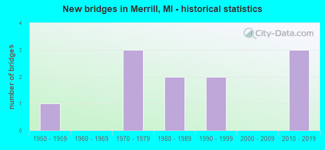
- New bridges - historical statistics
- 11950-1959
- 31970-1979
- 21980-1989
- 21990-1999
- 32010-2019


- Bridge Condition - Deck
- 50.0%Good
- 33.3%Satisfactory
- 16.7%Fair

- Bridge Condition - Superstructure
- 16.7%Very good
- 16.7%Good
- 50.0%Satisfactory
- 16.7%Fair

- Bridge Condition - Substructure
- 33.3%Very good
- 16.7%Good
- 50.0%Satisfactory

- Bridge Condition - Channel
- 9.1%Very good
- 27.3%Good
- 54.5%Satisfactory
- 9.1%Fair

- Bridge Condition - Culverts
- 60.0%Very good
- 20.0%Satisfactory
- 20.0%Fair
Find on map >> Show street view
Structure Number: 3179, Location: SEC 35-36 WHEELER TWP (Lat: 43.388231, Lng: -84.389575), Route carried "on" structure: County highway , Year Built: 1983, Status: Open, Structure Length: 1.95m (6.40ft), Average Daily Traffic: 95 (year 2003), Average Future Daily Traffic: 125 (year 2023), Design Load: HS 20+Mod, Features Intersected: BEAVER CREEK, Facility Carried by Structure: MASON ROAD
Minimum Vertical Clearance: 30.48m (100.00ft), Kilometerpoint: 1.017, Lanes on structure: 2, Owner: County Highway Agency, Approaching Roadway Width: 7.0m (23.0ft), Material/Design: Prestressed concrete, Design/Construction: Box Beam or Girders - Multiple, Number Of Spans In Main Unit: 1, Length of Maximum Span: 19.2m (63.0ft), Curb-To-Curb Width: 11.0m (36.1ft), Out-to-Out Width: 11.4m (37.4ft)
Condition: Deck: Good, Superstructure: Very good, Substructure: Very good, Channel: Good, Operating Rating: 57.6 metric tons, Method Used To Determine Operating Rating: Load Factor (LF), Inventory Rating: 34.5 metric tons, Method Used To Determine Inventory Rating: Load Factor (LF), Structural Evaluation: Equal to present desirable criteria, Deck Geometry: Superior to present desirable criteria, Waterway Adequacy: Equal to present desirable criteria, Approach Roadway Alignment: Equal to present desirable criteria, Designated Inspection Frequency: Every 24 months, Inspection Date: June 2021, Deck Structure Type: Concrete Precast Panels, Wearing Surface/Protective System: Wearing Surface: Bituminous, Membrane: Built-up
Find on map >> Show street view
Structure Number: 9088, Location: 1.5 MI EAST OF MERRILL (Lat: 43.411275, Lng: -84.302047), Route carried "on" structure: State highway 46, Year Built: 2018, Status: Open, Structure Length: 0.78m (2.56ft), Average Daily Traffic: 6,100 (year 2018), Truck Traffic: 6%, Average Future Daily Traffic: 6,750 (year 2038), Design Load: Greater than HL93, Features Intersected: PLANK ROAD #16 DRAIN
Minimum Vertical Clearance: 30.48m (100.00ft), Kilometerpoint: 5.506, Lanes on structure: 2, Base Highway Network: Yes (Inventory Route: 46, Subroute: 4), Owner: State Highway Agency, Approaching Roadway Width: 12.2m (40.0ft), Skew: 4 degrees, Material/Design: Concrete, Design/Construction: Culvert, Number Of Spans In Main Unit: 1, Length of Maximum Span: 7.8m (25.6ft), Curb-To-Curb Width: 12.2m (40.0ft), Out-to-Out Width: 19.7m (64.6ft)
Condition: Channel: Satisfactory, Culverts: Very good, Operating Rating: 79.1 metric tons, Method Used To Determine Operating Rating: Load and Resistance Factor Rating (LRFR) rating reported by rating factor(RF) method using HL-93 loadings, Inventory Rating: 61.2 metric tons, Method Used To Determine Inventory Rating: Load and Resistance Factor Rating (LRFR) rating reported by rating factor(RF) method using HL-93 loadings, Structural Evaluation: Equal to present desirable criteria, Deck Geometry: Somewhat better than minimum adequacy, Waterway Adequacy: Equal to present minimum criteria, Approach Roadway Alignment: Equal to present minimum criteria, Designated Inspection Frequency: Every 24 months, Inspection Date: November 2021, Wearing Surface/Protective System: Wearing Surface: Bituminous
Find on map >> Show street view
Structure Number: 9089, Location: 2.3 MI EAST OF MERRILL (Lat: 43.412003, Lng: -84.288289), Route carried "on" structure: State highway 46, Year Built: 2018, Status: Open, Structure Length: 0.67m (2.20ft), Average Daily Traffic: 6,100 (year 2017), Truck Traffic: 6%, Average Future Daily Traffic: 6,750 (year 2038), Design Load: Greater than HL93, Features Intersected: WHITMORE DRAIN
Minimum Vertical Clearance: 30.48m (100.00ft), Kilometerpoint: 6.626, Lanes on structure: 2, Base Highway Network: Yes (Inventory Route: 46, Subroute: 4), Owner: State Highway Agency, Approaching Roadway Width: 12.2m (40.0ft), Material/Design: Concrete, Design/Construction: Culvert, Number Of Spans In Main Unit: 1, Length of Maximum Span: 6.7m (22.0ft), Curb-To-Curb Width: 12.2m (40.0ft), Out-to-Out Width: 13.4m (44.0ft)
Condition: Channel: Satisfactory, Culverts: Very good, Operating Rating: 73.5 metric tons, Method Used To Determine Operating Rating: Load and Resistance Factor Rating (LRFR) rating reported by rating factor(RF) method using HL-93 loadings, Inventory Rating: 56.7 metric tons, Method Used To Determine Inventory Rating: Load and Resistance Factor Rating (LRFR) rating reported by rating factor(RF) method using HL-93 loadings, Structural Evaluation: Equal to present desirable criteria, Deck Geometry: Somewhat better than minimum adequacy, Waterway Adequacy: Equal to present minimum criteria, Approach Roadway Alignment: Equal to present minimum criteria, Designated Inspection Frequency: Every 24 months, Inspection Date: November 2021, Wearing Surface/Protective System: Wearing Surface: Bituminous
Find on map >> Show street view
Structure Number: 9235, Location: 0.7 MI N OF NELSON ROAD (Lat: 43.342258, Lng: -84.330253), Route carried "on" structure: County highway 7307, Year Built: 1959, Year Reconstructed: 1963, Status: Open, Structure Length: 2.95m (9.68ft), Average Daily Traffic: 1,886 (year 2010), Truck Traffic: 7%, Average Future Daily Traffic: 1,980 (year 2020), Design Load: H 20, Features Intersected: BEAVER CREEK, Facility Carried by Structure: MERRILL ROAD
Minimum Vertical Clearance: 30.48m (100.00ft), Kilometerpoint: 23.710, Lanes on structure: 2, Owner: County Highway Agency, Approaching Roadway Width: 11.0m (36.1ft), Material/Design: Prestressed concrete, Design/Construction: Box Beam or Girders - Multiple, Number Of Spans In Main Unit: 2, Length of Maximum Span: 14.6m (47.9ft), Curb-To-Curb Width: 7.0m (23.0ft), Out-to-Out Width: 8.3m (27.2ft)
Condition: Deck: Good, Superstructure: Good, Substructure: Satisfactory, Channel: Good, Operating Rating: 53.2 metric tons, Method Used To Determine Operating Rating: Field evaluation and documented engineering judgment, Inventory Rating: 31.9 metric tons, Method Used To Determine Inventory Rating: Field evaluation and documented engineering judgment, Structural Evaluation: Equal to present minimum criteria, Deck Geometry: High priority of corrective action, Waterway Adequacy: Equal to present desirable criteria, Approach Roadway Alignment: Better than present minimum criteria, Designated Inspection Frequency: Every 24 months, Inspection Date: September 2021, Deck Structure Type: Concrete Precast Panels, Wearing Surface/Protective System: Wearing Surface: Bituminous
Find on map >> Show street view
Structure Number: 9236, Location: 0.8 MI N OF O'HARA ROAD (Lat: 43.444964, Lng: -84.330533), Route carried "on" structure: ServiceCounty highway , Year Built: 1993, Status: Open, Structure Length: 0.73m (2.40ft), Average Daily Traffic: 1,202 (year 2010), Truck Traffic: 5%, Average Future Daily Traffic: 1,262 (year 2020), Design Load: HS 20+Mod, Features Intersected: WEEKS DRAIN, Facility Carried by Structure: MERRILL ROAD
Minimum Vertical Clearance: 30.48m (100.00ft), Kilometerpoint: 35.115, Lanes on structure: 2, Owner: County Highway Agency, Approaching Roadway Width: 10.1m (33.1ft), Material/Design: Concrete, Design/Construction: Culvert, Number Of Spans In Main Unit: 1, Length of Maximum Span: 7.3m (24.0ft), Curb-To-Curb Width: 10.1m (33.1ft), Out-to-Out Width: 13.4m (44.0ft)
Condition: Channel: Fair, Culverts: Satisfactory, Operating Rating: 71.0 metric tons, Method Used To Determine Operating Rating: Load Factor (LF) rating reported by rating factor (RF) method using MS18 loading, Inventory Rating: 42.4 metric tons, Method Used To Determine Inventory Rating: Load Factor (LF) rating reported by rating factor (RF) method using MS18 loading, Structural Evaluation: Equal to present minimum criteria, Deck Geometry: Somewhat better than minimum adequacy, Waterway Adequacy: Better than present minimum criteria, Approach Roadway Alignment: Equal to present desirable criteria, Designated Inspection Frequency: Every 24 months, Inspection Date: August 2021, Deck Structure Type: Concrete Precast Panels, Wearing Surface/Protective System: Wearing Surface: Monolithic Concrete, Deck Protection: Epoxy Coated Reinforcing
Find on map >> Show street view
Structure Number: 9349, Location: 0.4 MI E OF FENMORE ROAD (Lat: 43.433519, Lng: -84.342497), Route carried "on" structure: ServiceCounty highway , Year Built: 1973, Status: Open, Structure Length: 0.85m (2.79ft), Average Daily Traffic: 70 (year 2010), Truck Traffic: 5%, Average Future Daily Traffic: 74 (year 2020), Design Load: H 20, Features Intersected: WEEKS DRAIN, Facility Carried by Structure: O'HARA ROAD
Minimum Vertical Clearance: 30.48m (100.00ft), Kilometerpoint: 2.224, Lanes on structure: 2, Owner: County Highway Agency, Approaching Roadway Width: 10.1m (33.1ft), Skew: 3 degrees, Material/Design: Steel, Design/Construction: Culvert, Number Of Spans In Main Unit: 1, Length of Maximum Span: 6.4m (21.0ft), Curb-To-Curb Width: 9.1m (29.9ft), Out-to-Out Width: 14.0m (45.9ft)
Condition: Channel: Satisfactory, Culverts: Fair, Operating Rating: 36.9 metric tons, Method Used To Determine Operating Rating: Load Factor (LF) rating reported by rating factor (RF) method using MS18 loading, Inventory Rating: 22.0 metric tons, Method Used To Determine Inventory Rating: Load Factor (LF) rating reported by rating factor (RF) method using MS18 loading, Structural Evaluation: Somewhat better than minimum adequacy, Deck Geometry: Better than present minimum criteria, Waterway Adequacy: Equal to present desirable criteria, Approach Roadway Alignment: Equal to present desirable criteria, Designated Inspection Frequency: Every 24 months, Inspection Date: August 2021, Wearing Surface/Protective System: Wearing Surface: Bituminous
Find on map >> Show street view
Structure Number: 935, Location: 0.9 MI N OF O'HARA ROAD (Lat: 43.445786, Lng: -84.310581), Route carried "on" structure: ServiceCounty highway , Year Built: 2019, Status: Open, Structure Length: 0.76m (2.49ft), Average Daily Traffic: 145 (year 2008), Truck Traffic: 5%, Average Future Daily Traffic: 152 (year 2018), Design Load: Greater than HL93, Features Intersected: WEEKS DRAIN, Facility Carried by Structure: CHAPIN ROAD
Minimum Vertical Clearance: 30.48m (100.00ft), Kilometerpoint: 35.964, Lanes on structure: 2, Owner: County Highway Agency, Approaching Roadway Width: 9.1m (29.9ft), Material/Design: Aluminum, Iron, Design/Construction: Culvert, Number Of Spans In Main Unit: 1, Length of Maximum Span: 7.6m (24.9ft), Curb-To-Curb Width: 8.5m (27.9ft), Out-to-Out Width: 12.8m (42.0ft)
Condition: Channel: Very good, Culverts: Very good, Operating Rating: 70.6 metric tons, Method Used To Determine Operating Rating: Load and Resistance Factor Rating (LRFR) rating reported by rating factor(RF) method using HL-93 loadings, Inventory Rating: 54.4 metric tons, Method Used To Determine Inventory Rating: Load and Resistance Factor Rating (LRFR) rating reported by rating factor(RF) method using HL-93 loadings, Structural Evaluation: Equal to present desirable criteria, Deck Geometry: Equal to present minimum criteria, Waterway Adequacy: Equal to present desirable criteria, Approach Roadway Alignment: Equal to present desirable criteria, Length Of Structure Improvement: 1.46m (4.79ft), Designated Inspection Frequency: Every 24 months, Inspection Date: August 2021, Bridge Improvement Cost: $390,000, Roadway Improvement Cost: $170,000, Total Project Cost: $670,000, Deck Structure Type: Concrete Cast-file-Place, Wearing Surface/Protective System: Wearing Surface: Bituminous
Find on map >> Show street view
Structure Number: 9352, Location: 0.2 MI E OF FENMORE ROAD (Lat: 43.346378, Lng: -84.345989), Route carried "on" structure: ServiceCounty highway , Year Built: 1985, Status: Open, Structure Length: 3.41m (11.19ft), Average Daily Traffic: 236 (year 2010), Truck Traffic: 5%, Average Future Daily Traffic: 248 (year 2020), Design Load: HS 20+Mod, Features Intersected: BEAVER CREEK, Facility Carried by Structure: LAKEFIELD ROAD
Minimum Vertical Clearance: 30.48m (100.00ft), Kilometerpoint: 1.920, Lanes on structure: 2, Owner: County Highway Agency, Approaching Roadway Width: 10.4m (34.1ft), Skew: 4 degrees, Material/Design: Prestressed concrete, Design/Construction: Box Beam or Girders - Multiple, Number Of Spans In Main Unit: 2, Length of Maximum Span: 16.4m (53.8ft), Curb-To-Curb Width: 9.4m (30.8ft), Out-to-Out Width: 10.4m (34.1ft)
Condition: Deck: Satisfactory, Superstructure: Satisfactory, Substructure: Good, Channel: Good, Inventory Rating: 51.8 metric tons, Method Used To Determine Inventory Rating: Allowable Stress (AS), Structural Evaluation: Equal to present minimum criteria, Deck Geometry: Equal to present minimum criteria, Waterway Adequacy: Equal to present desirable criteria, Approach Roadway Alignment: Equal to present desirable criteria, Designated Inspection Frequency: Every 24 months, Inspection Date: September 2021, Deck Structure Type: Concrete Precast Panels, Wearing Surface/Protective System: Wearing Surface: Bituminous, Membrane: Built-up, Deck Protection: Epoxy Coated Reinforcing
Find on map >> Show street view
Structure Number: 9353, Location: 0.7 MI E OF MERIDIAN ROAD (Lat: 43.360964, Lng: -84.355717), Route carried "on" structure: ServiceCounty highway , Year Built: 1974, Status: Open, Structure Length: 2.37m (7.78ft), Average Daily Traffic: 51 (year 2010), Truck Traffic: 5%, Average Future Daily Traffic: 54 (year 2020), Design Load: HS 15, Features Intersected: BEAVER CREEK, Facility Carried by Structure: ROOSEVELT ROAD
Minimum Vertical Clearance: 30.48m (100.00ft), Kilometerpoint: 1.136, Lanes on structure: 2, Owner: County Highway Agency, Approaching Roadway Width: 8.0m (26.2ft), Material/Design: Wood or Timber, Design/Construction: Slab, Number Of Spans In Main Unit: 3, Length of Maximum Span: 7.9m (25.9ft), Curb-To-Curb Width: 8.0m (26.2ft), Out-to-Out Width: 8.2m (26.9ft)
Condition: Deck: Satisfactory, Superstructure: Satisfactory, Substructure: Satisfactory, Channel: Satisfactory, Operating Rating: 63.5 metric tons, Method Used To Determine Operating Rating: Allowable Stress (AS) rating reported by rating factor (RF) method using MS18 loading, Inventory Rating: 46.0 metric tons, Method Used To Determine Inventory Rating: Allowable Stress (AS) rating reported by rating factor (RF) method using MS18 loading, Structural Evaluation: Equal to present minimum criteria, Deck Geometry: Equal to present minimum criteria, Waterway Adequacy: Equal to present minimum criteria, Approach Roadway Alignment: Equal to present minimum criteria, Designated Inspection Frequency: Every 24 months, Inspection Date: September 2021, Deck Structure Type: Wood or Timber, Wearing Surface/Protective System: Wearing Surface: Bituminous
Find on map >> Show street view
Structure Number: 9355, Location: 0.2 MI N OF LAKEFIELD RD (Lat: 43.349392, Lng: -84.350336), Route carried "on" structure: ServiceCounty highway , Year Built: 1973, Status: Open, Structure Length: 2.37m (7.78ft), Average Daily Traffic: 168 (year 2010), Truck Traffic: 5%, Average Future Daily Traffic: 176 (year 2020), Design Load: H 20, Features Intersected: BEAVER CREEK, Facility Carried by Structure: FENMORE ROAD
Minimum Vertical Clearance: 30.48m (100.00ft), Kilometerpoint: 24.619, Lanes on structure: 2, Owner: County Highway Agency, Approaching Roadway Width: 9.0m (29.5ft), Material/Design: Wood or Timber, Design/Construction: Slab, Number Of Spans In Main Unit: 3, Length of Maximum Span: 7.9m (25.9ft), Curb-To-Curb Width: 8.0m (26.2ft), Out-to-Out Width: 8.2m (26.9ft)
Condition: Deck: Fair, Superstructure: Fair, Substructure: Satisfactory, Channel: Satisfactory, Operating Rating: 50.0 metric tons, Method Used To Determine Operating Rating: Allowable Stress (AS), Inventory Rating: 35.0 metric tons, Method Used To Determine Inventory Rating: Allowable Stress (AS), Structural Evaluation: Somewhat better than minimum adequacy, Deck Geometry: Somewhat better than minimum adequacy, Waterway Adequacy: Somewhat better than minimum adequacy, Approach Roadway Alignment: Equal to present minimum criteria, Designated Inspection Frequency: Every 24 months, Inspection Date: September 2021, Deck Structure Type: Wood or Timber, Wearing Surface/Protective System: Wearing Surface: Wood or Timber
Find on map >> Show street view
Structure Number: 9357, Location: 0.9MINOFROOSEVELTRD (Lat: 43.377992, Lng: -84.369822), Route carried "on" structure: ServiceCounty highway , Year Built: 1994, Status: Open, Structure Length: 2.13m (6.99ft), Average Daily Traffic: 156 (year 2002), Truck Traffic: 5%, Average Future Daily Traffic: 338 (year 2012), Design Load: HS 20, Features Intersected: BEAVER CREEK, Facility Carried by Structure: MERIDIAN ROAD
Minimum Vertical Clearance: 30.48m (100.00ft), Kilometerpoint: 9.896, Lanes on structure: 2, Owner: County Highway Agency, Approaching Roadway Width: 8.5m (27.9ft), Skew: 2 degrees, Material/Design: Prestressed concrete, Design/Construction: Box Beam or Girders - Multiple, Number Of Spans In Main Unit: 1, Length of Maximum Span: 20.1m (65.9ft), Curb-To-Curb Width: 8.8m (28.9ft), Out-to-Out Width: 9.4m (30.8ft)
Condition: Deck: Good, Superstructure: Satisfactory, Substructure: Very good, Channel: Satisfactory, Operating Rating: 57.0 metric tons, Method Used To Determine Operating Rating: Load Factor (LF) rating reported by rating factor (RF) method using MS18 loading, Inventory Rating: 34.0 metric tons, Method Used To Determine Inventory Rating: Load Factor (LF) rating reported by rating factor (RF) method using MS18 loading, Structural Evaluation: Equal to present minimum criteria, Waterway Adequacy: Meets minimum limits, Approach Roadway Alignment: Equal to present desirable criteria, Designated Inspection Frequency: Every 24 months, Inspection Date: September 2021, Deck Structure Type: Concrete Cast-file-Place, Wearing Surface/Protective System: Wearing Surface: Monolithic Concrete, Deck Protection: Epoxy Coated Reinforcing