Bridge Statistics for Mercer, Pennsylvania (PA)
Condition, Traffic, Stress, Structural Evaluation, Project Costs
- National Bridge Inventory (NBI) Statistics
- 41Number of bridges
- 358ft / 109mTotal length
- $6,708,000Total costs
- 197,763Total average daily traffic
- 64,572Total average daily truck traffic
- National Bridge Inventory (NBI) Registered Bridges for Mercer
- No street view available for this location
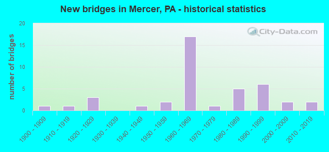
- New bridges - historical statistics
- 11900-1909
- 11910-1919
- 31920-1929
- 11940-1949
- 21950-1959
- 171960-1969
- 11970-1979
- 51980-1989
- 61990-1999
- 22000-2009
- 22010-2019

- Reconstructed bridges - Historical Statistics
- 21970-1979
- 31980-1989
- 21990-1999
- 22000-2009


- Bridge Condition - Deck
- 3.4%Excellent
- 24.1%Very good
- 34.5%Good
- 13.8%Satisfactory
- 20.7%Fair
- 3.4%Poor

- Bridge Condition - Superstructure
- 6.9%Excellent
- 27.6%Very good
- 20.7%Good
- 10.3%Satisfactory
- 20.7%Fair
- 13.8%Poor

- Bridge Condition - Substructure
- 3.4%Excellent
- 20.7%Very good
- 41.4%Good
- 13.8%Satisfactory
- 3.4%Fair
- 13.8%Poor
- 3.4%Serious

- Bridge Condition - Channel
- 8.3%Excellent
- 25.0%Very good
- 33.3%Good
- 16.7%Satisfactory
- 8.3%Fair
- 8.3%Poor

- Bridge Condition - Culverts
- 50.0%Very good
- 50.0%Good
Find on map >> Show street view
Structure Number: 25675, Location: COOLSPRING TOWNSHIP (Lat: 41.238028, Lng: -80.243256), Route carried "on" structure: State highway 58, Year Built: 1959, Status: Open, Structure Length: 0.88m (2.89ft), Average Daily Traffic: 3,582 (year 2020), Truck Traffic: 10%, Average Future Daily Traffic: 4,918 (year 2032), Design Load: HS 20, Features Intersected: OVER MUNNEL RUN
Minimum Vertical Clearance: 30+ m (98+ ft), Kilometerpoint: 39.398, Lanes on structure: 2, Base Highway Network: Yes, Owner: State Highway Agency, Approaching Roadway Width: 8.5m (27.9ft), Skew: 1 degrees, Material/Design: Concrete, Design/Construction: Tee Beam, Number Of Spans In Main Unit: 1, Length of Maximum Span: 8.2m (26.9ft), Curb-To-Curb Width: 11.6m (38.1ft), Out-to-Out Width: 13.3m (43.6ft)
Condition: Deck: Good, Superstructure: Very good, Substructure: Good, Channel: Fair, Operating Rating: 72.6 metric tons, Method Used To Determine Operating Rating: Load Factor (LF), Inventory Rating: 42.6 metric tons, Method Used To Determine Inventory Rating: Load Factor (LF), Structural Evaluation: Better than present minimum criteria, Deck Geometry: Somewhat better than minimum adequacy, Waterway Adequacy: Equal to present minimum criteria, Approach Roadway Alignment: Equal to present desirable criteria, Length Of Structure Improvement: 1.60m (5.25ft), Designated Inspection Frequency: Every 23 months, Inspection Date: April 2020, Bridge Improvement Cost: $2,000, Roadway Improvement Cost: $7,000, Total Project Cost: $30,000, Wearing Surface/Protective System: Wearing Surface: Bituminous
Find on map >> Show street view
Structure Number: 25676, Location: MERCER BOROUGH (Lat: 41.224039, Lng: -80.226581), Route carried "on" structure: State highway 58, Year Built: 1986, Status: Open, Structure Length: 3.72m (12.20ft), Average Daily Traffic: 4,641 (year 2022), Truck Traffic: 6%, Average Future Daily Traffic: 6,119 (year 2032), Design Load: HS 20, Features Intersected: OVER NESHANNOCK CREEK
Minimum Vertical Clearance: 30+ m (98+ ft), Kilometerpoint: 41.312, Lanes on structure: 2, Base Highway Network: Yes, Owner: State Highway Agency, Approaching Roadway Width: 7.3m (24.0ft), Material/Design: Prestressed concrete continuous, Design/Construction: Box Beam or Girders - Multiple, Number Of Spans In Main Unit: 2, Length of Maximum Span: 18.3m (60.0ft), Curb or Sidewalk Widths: Left: 0.2m (0.7ft), Right: 0.2m (0.7ft), Curb-To-Curb Width: 11.3m (37.1ft), Out-to-Out Width: 12.4m (40.7ft)
Condition: Deck: Good, Superstructure: Very good, Substructure: Good, Channel: Satisfactory, Operating Rating: 41.7 metric tons, Method Used To Determine Operating Rating: Load and Resistance Factor (LRFR), Inventory Rating: 29.9 metric tons, Method Used To Determine Inventory Rating: Load and Resistance Factor (LRFR), Structural Evaluation: Better than present minimum criteria, Deck Geometry: Somewhat better than minimum adequacy, Waterway Adequacy: Equal to present minimum criteria, Approach Roadway Alignment: Equal to present desirable criteria, Length Of Structure Improvement: 4.70m (15.42ft), Designated Inspection Frequency: Every 24 months, Inspection Date: October 2020, Deck Structure Type: Concrete Cast-file-Place, Wearing Surface/Protective System: Wearing Surface: Monolithic Concrete, Deck Protection: Epoxy Coated Reinforcing
Find on map >> Show street view
Structure Number: 25677, Location: FINDLEY TOWNSHIP (Lat: 41.200000, Lng: -80.175000), Route carried "on" structure: State highway 58, Year Built: 1965, Status: Open, Structure Length: 11.52m (37.80ft), Average Daily Traffic: 5,352 (year 2022), Truck Traffic: 5%, Average Future Daily Traffic: 6,120 (year 2032), Design Load: HS 20, Features Intersected: OVER SR 80 EB/WB,ZH CON
Minimum Vertical Clearance: 30+ m (98+ ft), Kilometerpoint: 47.321, Lanes on structure: 4, Lanes under structure: 12, Base Highway Network: Yes, Owner: State Highway Agency, Approaching Roadway Width: 17.1m (56.1ft), Skew: 24 degrees, Material/Design: Prestressed concrete, Design/Construction: Box Beam or Girders - Single/Spread, Number Of Spans In Main Unit: 5, Length of Maximum Span: 28.7m (94.2ft), Curb or Sidewalk Widths: Left: 0.5m (1.6ft), Right: 0.5m (1.6ft), Curb-To-Curb Width: 18.4m (60.4ft), Out-to-Out Width: 20.1m (65.9ft)
Condition: Deck: Satisfactory, Superstructure: Good, Substructure: Good, Operating Rating: 66.2 metric tons, Method Used To Determine Operating Rating: Load Factor (LF), Inventory Rating: 31.8 metric tons, Method Used To Determine Inventory Rating: Load Factor (LF), Structural Evaluation: Better than present minimum criteria, Deck Geometry: Somewhat better than minimum adequacy, Underclear: Superior to present desirable criteria, Approach Roadway Alignment: Better than present minimum criteria, Length Of Structure Improvement: 11.50m (37.73ft), Designated Inspection Frequency: Every 24 months, Inspection Date: August 2021, Bridge Improvement Cost: $178,000, Roadway Improvement Cost: $525,000, Total Project Cost: $2,405,000, Deck Structure Type: Concrete Cast-file-Place, Wearing Surface/Protective System: Wearing Surface: Bituminous, Membrane: Preformed Fabric
Find on map >> Show street view
Structure Number: 25791, Location: EAST LACKAWANNOCK TWP. (Lat: 41.192742, Lng: -80.240878), Route carried "on" structure: Interstate 80, Year Built: 1965, Year Reconstructed: 1993, Status: Open, Structure Length: 4.39m (14.40ft), Average Daily Traffic: 14,257 (year 2021), Truck Traffic: 44%, Average Future Daily Traffic: 17,657 (year 2032), Design Load: HS 20, Features Intersected: OVER SR 19 NB/SB,PERRY
Minimum Vertical Clearance: 30+ m (98+ ft), Kilometerpoint: 23.286, Lanes on structure: 2, Lanes under structure: 8, Base Highway Network: Yes, Owner: State Highway Agency, Approaching Roadway Width: 11.6m (38.1ft), Skew: 11 degrees, Material/Design: Prestressed concrete continuous, Design/Construction: Box Beam or Girders - Single/Spread, Number Of Spans In Main Unit: 3, Length of Maximum Span: 21.9m (71.9ft), Curb or Sidewalk Widths: Left: 0.2m (0.7ft), Right: 0.2m (0.7ft), Curb-To-Curb Width: 12.8m (42.0ft), Out-to-Out Width: 13.9m (45.6ft)
Condition: Deck: Good, Superstructure: Good, Substructure: Good, Operating Rating: 92.5 metric tons, Method Used To Determine Operating Rating: Load Factor (LF), Inventory Rating: 38.1 metric tons, Method Used To Determine Inventory Rating: Load Factor (LF), Structural Evaluation: Better than present minimum criteria, Deck Geometry: Equal to present desirable criteria, Underclear: Better than present minimum criteria, Approach Roadway Alignment: Equal to present desirable criteria, Length Of Structure Improvement: 4.40m (14.44ft), Designated Inspection Frequency: Every 48 months, Inspection Date: July 2019, Deck Structure Type: Concrete Cast-file-Place, Wearing Surface/Protective System: Wearing Surface: Bituminous, Membrane: Preformed Fabric, Deck Protection: Epoxy Coated Reinforcing
Find on map >> Show street view
Structure Number: 25792, Location: EAST LACKAWANNOCK TWP. (Lat: 41.193053, Lng: -80.240875), Route carried "on" structure: Interstate 80, Year Built: 1965, Year Reconstructed: 1993, Status: Open, Structure Length: 4.42m (14.50ft), Average Daily Traffic: 14,215 (year 2021), Truck Traffic: 44%, Average Future Daily Traffic: 16,802 (year 2032), Design Load: HS 20, Features Intersected: OVER SR 19 NB/SB,PERRY
Minimum Vertical Clearance: 30+ m (98+ ft), Kilometerpoint: 23.323, Lanes on structure: 2, Lanes under structure: 8, Base Highway Network: Yes, Owner: State Highway Agency, Approaching Roadway Width: 11.6m (38.1ft), Skew: 11 degrees, Material/Design: Prestressed concrete continuous, Design/Construction: Box Beam or Girders - Single/Spread, Number Of Spans In Main Unit: 3, Length of Maximum Span: 21.9m (71.9ft), Curb or Sidewalk Widths: Left: 0.2m (0.7ft), Right: 0.2m (0.7ft), Curb-To-Curb Width: 12.8m (42.0ft), Out-to-Out Width: 13.9m (45.6ft)
Condition: Deck: Satisfactory, Superstructure: Good, Substructure: Good, Operating Rating: 87.1 metric tons, Method Used To Determine Operating Rating: Load Factor (LF), Inventory Rating: 40.8 metric tons, Method Used To Determine Inventory Rating: Load Factor (LF), Structural Evaluation: Better than present minimum criteria, Deck Geometry: Equal to present desirable criteria, Underclear: Superior to present desirable criteria, Approach Roadway Alignment: Equal to present desirable criteria, Length Of Structure Improvement: 5.30m (17.39ft), Designated Inspection Frequency: Every 48 months, Inspection Date: June 2019, Deck Structure Type: Concrete Cast-file-Place, Wearing Surface/Protective System: Wearing Surface: Bituminous, Membrane: Preformed Fabric, Deck Protection: Epoxy Coated Reinforcing
Find on map >> Show street view
Structure Number: 25794, Location: FINDLEY TOWNSHIP (Lat: 41.194122, Lng: -80.222531), Route carried "on" structure: Interstate 80, Year Built: 1999, Status: Open, Structure Length: 12.19m (39.99ft), Average Daily Traffic: 14,215 (year 2021), Truck Traffic: 44%, Average Future Daily Traffic: 16,802 (year 2032), Design Load: HS 25 or greater, Features Intersected: OVER ABND'N.RR/NESHNK.CK
Minimum Vertical Clearance: 30+ m (98+ ft), Kilometerpoint: 24.964, Lanes on structure: 2, Base Highway Network: Yes, Owner: State Highway Agency, Approaching Roadway Width: 10.4m (34.1ft), Skew: 10 degrees, Material/Design: Steel continuous, Design/Construction: Stringer/Multi-beam, Number Of Spans In Main Unit: 4, Length of Maximum Span: 34.7m (113.8ft), Curb or Sidewalk Widths: Left: 0.2m (0.7ft), Right: 0.2m (0.7ft), Curb-To-Curb Width: 10.4m (34.1ft), Out-to-Out Width: 11.5m (37.7ft)
Condition: Deck: Good, Superstructure: Good, Substructure: Good, Channel: Very good, Operating Rating: 79.8 metric tons, Method Used To Determine Operating Rating: Load Factor (LF), Inventory Rating: 48.1 metric tons, Method Used To Determine Inventory Rating: Load Factor (LF), Structural Evaluation: Better than present minimum criteria, Deck Geometry: Meets minimum limits, Underclear: High priority of corrective action, Waterway Adequacy: Superior to present desirable criteria, Approach Roadway Alignment: Equal to present desirable criteria, Length Of Structure Improvement: 13.20m (43.31ft), Designated Inspection Frequency: Every 48 months, Inspection Date: June 2019, Deck Structure Type: Concrete Cast-file-Place, Wearing Surface/Protective System: Wearing Surface: Bituminous, Membrane: Preformed Fabric, Deck Protection: Epoxy Coated Reinforcing
Find on map >> Show street view
Structure Number: 25796, Location: FINDLEY TOWNSHIP (Lat: 41.194061, Lng: -80.203567), Route carried "on" structure: Interstate 80, Year Built: 1965, Year Reconstructed: 1998, Status: Open, Structure Length: 4.27m (14.01ft), Average Daily Traffic: 14,257 (year 2021), Truck Traffic: 44%, Average Future Daily Traffic: 17,657 (year 2032), Design Load: HS 25 or greater, Features Intersected: OVER SR 258,BUTLER PIKE
Minimum Vertical Clearance: 30+ m (98+ ft), Kilometerpoint: 26.528, Lanes on structure: 2, Lanes under structure: 2, Base Highway Network: Yes, Owner: State Highway Agency, Approaching Roadway Width: 11.6m (38.1ft), Skew: 14 degrees, Material/Design: Prestressed concrete continuous, Design/Construction: Box Beam or Girders - Single/Spread, Number Of Spans In Main Unit: 3, Length of Maximum Span: 16.8m (55.1ft), Curb or Sidewalk Widths: Left: 0.2m (0.7ft), Right: 0.2m (0.7ft), Curb-To-Curb Width: 12.8m (42.0ft), Out-to-Out Width: 13.9m (45.6ft)
Condition: Deck: Fair, Superstructure: Satisfactory, Substructure: Satisfactory, Operating Rating: 81.6 metric tons, Method Used To Determine Operating Rating: Load Factor (LF), Inventory Rating: 43.5 metric tons, Method Used To Determine Inventory Rating: Load Factor (LF), Structural Evaluation: Equal to present minimum criteria, Deck Geometry: Equal to present desirable criteria, Underclear: Somewhat better than minimum adequacy, Approach Roadway Alignment: Equal to present desirable criteria, Length Of Structure Improvement: 5.20m (17.06ft), Designated Inspection Frequency: Every 24 months, Inspection Date: June 2021, Deck Structure Type: Concrete Cast-file-Place, Wearing Surface/Protective System: Wearing Surface: Bituminous, Membrane: Preformed Fabric, Deck Protection: Epoxy Coated Reinforcing
Find on map >> Show street view
Structure Number: 25797, Location: FINDLEY TOWNSHIP (Lat: 41.194392, Lng: -80.203964), Route carried "on" structure: Interstate 80, Year Built: 1966, Year Reconstructed: 1999, Status: Open, Structure Length: 4.27m (14.01ft), Average Daily Traffic: 14,215 (year 2021), Truck Traffic: 44%, Average Future Daily Traffic: 16,802 (year 2032), Design Load: HS 25 or greater, Features Intersected: OVER SR 258,BUTLER PIKE
Minimum Vertical Clearance: 30+ m (98+ ft), Kilometerpoint: 26.572, Lanes on structure: 2, Lanes under structure: 2, Base Highway Network: Yes, Owner: State Highway Agency, Approaching Roadway Width: 11.6m (38.1ft), Skew: 14 degrees, Material/Design: Prestressed concrete, Design/Construction: Box Beam or Girders - Single/Spread, Number Of Spans In Main Unit: 3, Length of Maximum Span: 16.8m (55.1ft), Curb or Sidewalk Widths: Left: 0.2m (0.7ft), Right: 0.2m (0.7ft), Curb-To-Curb Width: 12.8m (42.0ft), Out-to-Out Width: 13.9m (45.6ft)
Condition: Deck: Fair, Superstructure: Good, Substructure: Good, Operating Rating: 81.6 metric tons, Method Used To Determine Operating Rating: Load Factor (LF), Inventory Rating: 43.5 metric tons, Method Used To Determine Inventory Rating: Load Factor (LF), Structural Evaluation: Better than present minimum criteria, Deck Geometry: Equal to present desirable criteria, Underclear: Somewhat better than minimum adequacy, Approach Roadway Alignment: Equal to present desirable criteria, Length Of Structure Improvement: 5.20m (17.06ft), Designated Inspection Frequency: Every 24 months, Inspection Date: June 2021, Bridge Improvement Cost: $11,000, Roadway Improvement Cost: $33,000, Total Project Cost: $151,000, Deck Structure Type: Concrete Cast-file-Place, Wearing Surface/Protective System: Wearing Surface: Bituminous, Membrane: Preformed Fabric, Deck Protection: Epoxy Coated Reinforcing
Find on map >> Show street view
Structure Number: 25821, Location: EAST LACKAWANNOCK TWP. (Lat: 41.185600, Lng: -80.267458), Route carried "on" structure: State highway 158, Year Built: 1965, Year Reconstructed: 2007, Status: Open, Structure Length: 11.03m (36.19ft), Average Daily Traffic: 1,684 (year 2022), Truck Traffic: 7%, Average Future Daily Traffic: 1,888 (year 2032), Design Load: HS 20, Features Intersected: OVER SR 80,EB/WB
Minimum Vertical Clearance: 30+ m (98+ ft), Kilometerpoint: 8.164, Lanes on structure: 2, Lanes under structure: 8, Owner: State Highway Agency, Approaching Roadway Width: 7.9m (25.9ft), Skew: 4 degrees, Material/Design: Steel, Design/Construction: Stringer/Multi-beam, Number Of Spans In Main Unit: 3, Number Of Approach Spans: 2, Length of Maximum Span: 25.9m (85.0ft), Curb or Sidewalk Widths: Left: 0.5m (1.6ft), Right: 0.5m (1.6ft), Curb-To-Curb Width: 9.1m (29.9ft), Out-to-Out Width: 10.9m (35.8ft)
Condition: Deck: Fair, Superstructure: Fair, Substructure: Satisfactory, Operating Rating: 58.1 metric tons, Method Used To Determine Operating Rating: Load Factor (LF), Inventory Rating: 34.5 metric tons, Method Used To Determine Inventory Rating: Load Factor (LF), Structural Evaluation: Somewhat better than minimum adequacy, Deck Geometry: Somewhat better than minimum adequacy, Underclear: Somewhat better than minimum adequacy, Approach Roadway Alignment: Equal to present desirable criteria, Length Of Structure Improvement: 11.00m (36.09ft), Designated Inspection Frequency: Every 24 months, Inspection Date: November 2021, Bridge Improvement Cost: $60,000, Roadway Improvement Cost: $175,000, Total Project Cost: $804,000, Deck Structure Type: Concrete Cast-file-Place, Wearing Surface/Protective System: Wearing Surface: Bituminous, Membrane: Preformed Fabric
Find on map >> Show street view
Structure Number: 25947, Location: SPRINGFIELD TOWNSHIP (Lat: 41.167167, Lng: -80.214656), Route carried "on" structure: State highway , Year Built: 1904, Year Reconstructed: 2014, Status: Open, Structure Length: 1.49m (4.89ft), Average Daily Traffic: 223 (year 2020), Truck Traffic: 6%, Average Future Daily Traffic: 271 (year 2032), Design Load: HS 20, Features Intersected: OVER MILL RUN, Facility Carried by Structure: SR 2004,MILBURN RD
Minimum Vertical Clearance: 30+ m (98+ ft), Kilometerpoint: 0.991, Lanes on structure: 2, Owner: State Highway Agency, Approaching Roadway Width: 4.0m (13.1ft), Skew: 1 degrees, Material/Design: Prestressed concrete, Design/Construction: Box Beam or Girders - Multiple, Number Of Spans In Main Unit: 1, Length of Maximum Span: 14.0m (45.9ft), Curb-To-Curb Width: 4.5m (14.8ft), Out-to-Out Width: 5.0m (16.4ft)
Condition: Deck: Very good, Superstructure: Fair, Substructure: Good, Channel: Satisfactory, Operating Rating: 47.2 metric tons, Method Used To Determine Operating Rating: Load Factor (LF), Inventory Rating: 6.4 metric tons, Method Used To Determine Inventory Rating: Load Factor (LF), Structural Evaluation: High priority of corrective action, Deck Geometry: High priority of replacement, Waterway Adequacy: Better than present minimum criteria, Approach Roadway Alignment: Equal to present desirable criteria, Length Of Structure Improvement: 2.20m (7.22ft), Designated Inspection Frequency: Every 24 months, Inspection Date: October 2021, Bridge Improvement Cost: $2,000, Roadway Improvement Cost: $5,000, Total Project Cost: $24,000, Wearing Surface/Protective System: Wearing Surface: Bituminous
Find on map >> Show street view
Structure Number: 25957, Location: MERCER BOROUGH (Lat: 41.229333, Lng: -80.229072), Route carried "on" structure: State highway , Year Built: 1910, Year Reconstructed: 1979, Status: Open, Structure Length: 1.01m (3.31ft), Average Daily Traffic: 793 (year 2020), Truck Traffic: 7%, Average Future Daily Traffic: 1,187 (year 2032), Design Load: HS 20+Mod, Features Intersected: OVER MUNNEL RUN, Facility Carried by Structure: SR 2013,HOME ST
Minimum Vertical Clearance: 30+ m (98+ ft), Kilometerpoint: 0.000, Lanes on structure: 2, Owner: State Highway Agency, Approaching Roadway Width: 5.5m (18.0ft), Material/Design: Steel, Design/Construction: Stringer/Multi-beam, Number Of Spans In Main Unit: 1, Length of Maximum Span: 9.1m (29.9ft), Curb or Sidewalk Widths: Left: 0.1m (0.3ft), Right: 0.1m (0.3ft), Curb-To-Curb Width: 6.6m (21.7ft), Out-to-Out Width: 7.2m (23.6ft)
Condition: Deck: Poor, Superstructure: Poor, Substructure: Poor, Channel: Poor, Operating Rating: 89.8 metric tons, Method Used To Determine Operating Rating: Load Factor (LF), Inventory Rating: 83.5 metric tons, Method Used To Determine Inventory Rating: Load Factor (LF), Structural Evaluation: Meets minimum limits, Deck Geometry: High priority of corrective action, Waterway Adequacy: Equal to present desirable criteria, Approach Roadway Alignment: Meets minimum limits, Length Of Structure Improvement: 1.60m (5.25ft), Designated Inspection Frequency: Every 24 months, Inspection Date: April 2021, Bridge Improvement Cost: $2,000, Roadway Improvement Cost: $6,000, Total Project Cost: $26,000, Deck Structure Type: Corrugated Steel, Wearing Surface/Protective System: Wearing Surface: Bituminous
Find on map >> Show street view
Structure Number: 25958, Location: MERCER BOROUGH (Lat: 41.225878, Lng: -80.224658), Route carried "on" structure: State highway , Year Built: 1941, Year Reconstructed: 1981, Status: Open, Structure Length: 2.96m (9.71ft), Average Daily Traffic: 1,520 (year 2022), Truck Traffic: 6%, Average Future Daily Traffic: 1,668 (year 2032), Design Load: HS 20, Features Intersected: OVER OTTER CREEK, Facility Carried by Structure: SR 2014,SCRUBGRASS
Minimum Vertical Clearance: 30+ m (98+ ft), Kilometerpoint: 0.291, Lanes on structure: 2, Owner: State Highway Agency, Approaching Roadway Width: 6.1m (20.0ft), Material/Design: Steel, Design/Construction: Girder and Floorbeam System, Number Of Spans In Main Unit: 1, Length of Maximum Span: 28.3m (92.8ft), Curb or Sidewalk Widths: Left: 1.5m (4.9ft), Right: 0.0m, Curb-To-Curb Width: 7.0m (23.0ft), Out-to-Out Width: 8.7m (28.5ft)
Condition: Deck: Satisfactory, Superstructure: Fair, Substructure: Satisfactory, Channel: Poor, Operating Rating: 59.0 metric tons, Method Used To Determine Operating Rating: Load Factor (LF), Inventory Rating: 35.4 metric tons, Method Used To Determine Inventory Rating: Load Factor (LF), Structural Evaluation: Somewhat better than minimum adequacy, Deck Geometry: High priority of corrective action, Waterway Adequacy: Equal to present desirable criteria, Approach Roadway Alignment: Equal to present desirable criteria, Length Of Structure Improvement: 3.70m (12.14ft), Designated Inspection Frequency: Every 24 months, Critical Feature Inspection Frequency: Every 24 months, Other Special Inspection Frequency: Every 6 months, Inspection Date: October 2021, Critical Feature Inspection Date: October 2021, Other Special Inspection Date: October 2021, Bridge Improvement Cost: $10,000, Roadway Improvement Cost: $30,000, Total Project Cost: $137,000, Deck Structure Type: Concrete Cast-file-Place, Wearing Surface/Protective System: Wearing Surface: Monolithic Concrete, Deck Protection: Epoxy Coated Reinforcing
Find on map >> Show street view
Structure Number: 25959, Location: FINDLEY TOWNSHIP (Lat: 41.225275, Lng: -80.216864), Route carried "on" structure: State highway , Year Built: 1954, Status: Open, Structure Length: 3.84m (12.60ft), Average Daily Traffic: 1,520 (year 2022), Truck Traffic: 6%, Average Future Daily Traffic: 1,668 (year 2032), Design Load: HS 20, Features Intersected: OVER COOL SPRING, Facility Carried by Structure: SR 2014,SCRUBGRASS
Minimum Vertical Clearance: 30+ m (98+ ft), Kilometerpoint: 0.856, Lanes on structure: 2, Owner: State Highway Agency, Approaching Roadway Width: 5.5m (18.0ft), Skew: 4 degrees, Material/Design: Steel, Design/Construction: Stringer/Multi-beam, Number Of Spans In Main Unit: 2, Length of Maximum Span: 18.3m (60.0ft), Curb or Sidewalk Widths: Left: 0.2m (0.7ft), Right: 1.2m (3.9ft), Curb-To-Curb Width: 7.3m (24.0ft), Out-to-Out Width: 8.2m (26.9ft)
Condition: Deck: Fair, Superstructure: Poor, Substructure: Poor, Channel: Fair, Operating Rating: 39.0 metric tons, Method Used To Determine Operating Rating: Load Factor (LF), Inventory Rating: 23.6 metric tons, Method Used To Determine Inventory Rating: Load Factor (LF), Structural Evaluation: Meets minimum limits, Deck Geometry: Meets minimum limits, Waterway Adequacy: Equal to present desirable criteria, Approach Roadway Alignment: Equal to present desirable criteria, Length Of Structure Improvement: 3.80m (12.47ft), Designated Inspection Frequency: Every 24 months, Inspection Date: April 2021, Bridge Improvement Cost: $29,000, Roadway Improvement Cost: $85,000, Total Project Cost: $389,000, Deck Structure Type: Closed Grating
Find on map >> Show street view
Structure Number: 26076, Location: ORR ROAD,COOLSPRINGS TWP. (Lat: 41.238494, Lng: -80.201819), Route carried "on" structure: City street T499, Year Built: 1928, Year Reconstructed: 1991, Status: Posted for load, Structure Length: 3.90m (12.80ft), Average Daily Traffic: 117 (year 2019), Truck Traffic: 4%, Average Future Daily Traffic: 160 (year 2039), Design Load: H 10, Features Intersected: OVER B.&L.E. RAILROAD
Minimum Vertical Clearance: 30+ m (98+ ft), Kilometerpoint: 0.000, Lanes on structure: 2, Owner: County Highway Agency, Maintenance Responsibility: Town or Township Highway Agency, Approaching Roadway Width: 6.7m (22.0ft), Skew: 4 degrees, Material/Design: Steel, Design/Construction: Girder and Floorbeam System, Number Of Spans In Main Unit: 3, Length of Maximum Span: 18.0m (59.1ft), Curb or Sidewalk Widths: Left: 0.2m (0.7ft), Right: 0.2m (0.7ft), Curb-To-Curb Width: 7.3m (24.0ft), Out-to-Out Width: 7.6m (24.9ft)
Condition: Deck: Very good, Superstructure: Fair, Substructure: Serious, Operating Rating: 42.6 metric tons, Method Used To Determine Operating Rating: Load Factor (LF), Inventory Rating: 25.4 metric tons, Method Used To Determine Inventory Rating: Load Factor (LF), Structural Evaluation: High priority of corrective action, Deck Geometry: Somewhat better than minimum adequacy, Underclear: High priority of corrective action, Approach Roadway Alignment: Meets minimum limits, Bridge Posting: Required (Relationship of Operating Rating to Maximum Legal Load: 0.1 - 9.9% below), Length Of Structure Improvement: 3.90m (12.80ft), Designated Inspection Frequency: Every 24 months, Critical Feature Inspection Frequency: Every 12 months, Other Special Inspection Frequency: Every 12 months, Inspection Date: September 2020, Critical Feature Inspection Date: September 2021, Other Special Inspection Date: September 2021, Total Project Cost: $2,739,000 ( Estimate for 2014), Deck Structure Type: Open Grating
Find on map >> Show street view
Structure Number: 26077, Location: E CORNELL RD COOLSPRINGS (Lat: 41.259086, Lng: -80.225508), Route carried "on" structure: City street 7201, Year Built: 1985, Status: Open, Structure Length: 2.83m (9.28ft), Average Daily Traffic: 632 (year 2018), Truck Traffic: 4%, Average Future Daily Traffic: 880 (year 2038), Design Load: HS 25 or greater, Features Intersected: OVER OTTER CREEK, Facility Carried by Structure: BRIDGE 2010,T-539
Minimum Vertical Clearance: 30+ m (98+ ft), Kilometerpoint: 0.000, Lanes on structure: 2, Owner: County Highway Agency, Approaching Roadway Width: 7.3m (24.0ft), Material/Design: Prestressed concrete, Design/Construction: Box Beam or Girders - Multiple, Number Of Spans In Main Unit: 1, Length of Maximum Span: 27.7m (90.9ft), Curb-To-Curb Width: 7.6m (24.9ft), Out-to-Out Width: 8.6m (28.2ft)
Condition: Deck: Good, Superstructure: Very good, Substructure: Very good, Channel: Excellent, Operating Rating: 89.8 metric tons, Method Used To Determine Operating Rating: Load Factor (LF), Inventory Rating: 45.4 metric tons, Method Used To Determine Inventory Rating: Load Factor (LF), Structural Evaluation: Equal to present desirable criteria, Deck Geometry: Meets minimum limits, Waterway Adequacy: Equal to present desirable criteria, Approach Roadway Alignment: Equal to present desirable criteria, Length Of Structure Improvement: 2.80m (9.19ft), Designated Inspection Frequency: Every 24 months, Inspection Date: July 2020, Deck Structure Type: Other, Wearing Surface/Protective System: Wearing Surface: Bituminous, Membrane: Preformed Fabric
Find on map >> Show street view
Structure Number: 26096, Location: OLD MERCER RD E.LACK TWP (Lat: 41.189358, Lng: -80.228489), Route carried "on" structure: City street 7204, Year Built: 1922, Status: Posted for load, Structure Length: 3.17m (10.40ft), Average Daily Traffic: 341 (year 2019), Truck Traffic: 4%, Average Future Daily Traffic: 480 (year 2039), Design Load: H 15, Features Intersected: OVER NESHANNOCK CREEK, Facility Carried by Structure: BRIDGE 2606,T-401
Minimum Vertical Clearance: 4.40m (14.44ft), Kilometerpoint: 0.000, Lanes on structure: 1, Owner: County Highway Agency, Approaching Roadway Width: 3.7m (12.1ft), Material/Design: Steel, Design/Construction: Truss - Thru, Number Of Spans In Main Unit: 1, Length of Maximum Span: 31.1m (102.0ft), Curb or Sidewalk Widths: Left: 0.2m (0.7ft), Right: 0.2m (0.7ft), Curb-To-Curb Width: 5.2m (17.1ft), Out-to-Out Width: 5.7m (18.7ft)
Condition: Deck: Good, Superstructure: Poor, Substructure: Fair, Channel: Good, Operating Rating: 13.6 metric tons, Method Used To Determine Operating Rating: Load Factor (LF), Inventory Rating: 8.2 metric tons, Method Used To Determine Inventory Rating: Load Factor (LF), Structural Evaluation: High priority of replacement, Deck Geometry: High priority of replacement, Waterway Adequacy: Equal to present desirable criteria, Approach Roadway Alignment: Meets minimum limits, Bridge Posting: Required (Relationship of Operating Rating to Maximum Legal Load: > 39.9% below), Length Of Structure Improvement: 3.20m (10.50ft), Designated Inspection Frequency: Every 24 months, Critical Feature Inspection Frequency: Every 12 months, Other Special Inspection Frequency: Every 12 months, Inspection Date: September 2020, Critical Feature Inspection Date: September 2021, Other Special Inspection Date: September 2021, Bridge Improvement Cost: $91,000, Roadway Improvement Cost: $265,000, Total Project Cost: $1,000, Deck Structure Type: Concrete Cast-file-Place, Wearing Surface/Protective System: Wearing Surface: Monolithic Concrete, Deck Protection: Epoxy Coated Reinforcing
Find on map >> Show street view
Structure Number: 26112, Location: OAKLAND RD.,FINDLEY TWP. (Lat: 41.234086, Lng: -80.218756), Route carried "on" structure: City street 7206, Year Built: 1965, Status: Open, Structure Length: 2.83m (9.28ft), Average Daily Traffic: 594 (year 2018), Truck Traffic: 4%, Average Future Daily Traffic: 830 (year 2038), Design Load: HS 20, Features Intersected: OVER OTTER CREEK, Facility Carried by Structure: BRIDGE 2603,T-682
Minimum Vertical Clearance: 30+ m (98+ ft), Kilometerpoint: 0.000, Lanes on structure: 2, Owner: County Highway Agency, Approaching Roadway Width: 7.0m (23.0ft), Skew: 3 degrees, Material/Design: Steel, Design/Construction: Stringer/Multi-beam, Number Of Spans In Main Unit: 1, Length of Maximum Span: 27.4m (89.9ft), Curb-To-Curb Width: 8.5m (27.9ft), Out-to-Out Width: 9.1m (29.9ft)
Condition: Deck: Fair, Superstructure: Fair, Substructure: Satisfactory, Channel: Good, Operating Rating: 57.2 metric tons, Method Used To Determine Operating Rating: Load Factor (LF), Inventory Rating: 34.5 metric tons, Method Used To Determine Inventory Rating: Load Factor (LF), Structural Evaluation: Somewhat better than minimum adequacy, Deck Geometry: Somewhat better than minimum adequacy, Waterway Adequacy: Equal to present desirable criteria, Approach Roadway Alignment: Better than present minimum criteria, Length Of Structure Improvement: 2.80m (9.19ft), Designated Inspection Frequency: Every 24 months, Inspection Date: July 2020, Deck Structure Type: Open Grating
Find on map >> Show street view
Structure Number: 26113, Location: WOODLAND RD.,FINDLEY TWP. (Lat: 41.188203, Lng: -80.202708), Route carried "on" structure: City street 7206, Year Built: 1986, Status: Open, Structure Length: 1.28m (4.20ft), Average Daily Traffic: 79 (year 2018), Truck Traffic: 4%, Average Future Daily Traffic: 110 (year 2038), Design Load: HS 25 or greater, Features Intersected: OVER PINE RUN, Facility Carried by Structure: BRIDGE 2633,T-698
Minimum Vertical Clearance: 30+ m (98+ ft), Kilometerpoint: 0.000, Lanes on structure: 2, Owner: County Highway Agency, Approaching Roadway Width: 7.3m (24.0ft), Skew: 2 degrees, Material/Design: Prestressed concrete, Design/Construction: Box Beam or Girders - Multiple, Number Of Spans In Main Unit: 1, Length of Maximum Span: 12.2m (40.0ft), Curb-To-Curb Width: 7.5m (24.6ft), Out-to-Out Width: 8.6m (28.2ft)
Condition: Deck: Very good, Superstructure: Very good, Substructure: Very good, Channel: Good, Operating Rating: 68.0 metric tons, Method Used To Determine Operating Rating: Load Factor (LF), Inventory Rating: 39.9 metric tons, Method Used To Determine Inventory Rating: Load Factor (LF), Structural Evaluation: Equal to present desirable criteria, Deck Geometry: Equal to present minimum criteria, Waterway Adequacy: Equal to present desirable criteria, Approach Roadway Alignment: Equal to present desirable criteria, Length Of Structure Improvement: 1.30m (4.27ft), Designated Inspection Frequency: Every 24 months, Inspection Date: August 2020, Deck Structure Type: Other, Wearing Surface/Protective System: Wearing Surface: Bituminous, Membrane: Preformed Fabric
Find on map >> Show street view
Structure Number: 26114, Location: CRIBBS ROAD, FINDLEY TWP (Lat: 41.191617, Lng: -80.187447), Route carried "on" structure: City street 7206, Year Built: 1994, Status: Open, Structure Length: 0.79m (2.59ft), Average Daily Traffic: 48 (year 2019), Truck Traffic: 4%, Average Future Daily Traffic: 70 (year 2039), Design Load: HS 25 or greater, Features Intersected: OVER PINE RUN, Facility Carried by Structure: BRIDGE 2631,T-724
Minimum Vertical Clearance: 30+ m (98+ ft), Kilometerpoint: 0.000, Lanes on structure: 2, Owner: County Highway Agency, Approaching Roadway Width: 7.3m (24.0ft), Skew: 2 degrees, Material/Design: Prestressed concrete, Design/Construction: Slab, Number Of Spans In Main Unit: 1, Length of Maximum Span: 7.6m (24.9ft), Curb-To-Curb Width: 7.3m (24.0ft), Out-to-Out Width: 8.6m (28.2ft)
Condition: Deck: Very good, Superstructure: Very good, Substructure: Very good, Channel: Very good, Operating Rating: 83.5 metric tons, Method Used To Determine Operating Rating: Load Factor (LF), Inventory Rating: 49.9 metric tons, Method Used To Determine Inventory Rating: Load Factor (LF), Structural Evaluation: Equal to present desirable criteria, Deck Geometry: Equal to present minimum criteria, Waterway Adequacy: Equal to present desirable criteria, Approach Roadway Alignment: Equal to present desirable criteria, Length Of Structure Improvement: 0.80m (2.62ft), Designated Inspection Frequency: Every 24 months, Inspection Date: July 2021, Wearing Surface/Protective System: Wearing Surface: Bituminous, Membrane: Preformed Fabric
Find on map >> Show street view
Structure Number: 26272, Location: MILL RUN RD, SPRINGFIELD (Lat: 41.168833, Lng: -80.208861), Route carried "on" structure: City street 7226, Year Built: 1987, Status: Open, Structure Length: 0.67m (2.20ft), Average Daily Traffic: 71 (year 2018), Truck Traffic: 4%, Average Future Daily Traffic: 100 (year 2038), Design Load: HS 25 or greater, Features Intersected: OVER MILL CREEK, Facility Carried by Structure: BRIDGE 3004,T-696
Minimum Vertical Clearance: 30+ m (98+ ft), Kilometerpoint: 0.000, Lanes on structure: 2, Owner: County Highway Agency, Approaching Roadway Width: 7.3m (24.0ft), Material/Design: Concrete, Design/Construction: Culvert, Number Of Spans In Main Unit: 1, Length of Maximum Span: 6.1m (20.0ft), Curb-To-Curb Width: 7.5m (24.6ft), Out-to-Out Width: 8.2m (26.9ft)
Condition: Channel: Good, Culverts: Good, Operating Rating: 39.0 metric tons, Method Used To Determine Operating Rating: Load Factor (LF), Inventory Rating: 23.6 metric tons, Method Used To Determine Inventory Rating: Load Factor (LF), Structural Evaluation: Equal to present minimum criteria, Deck Geometry: Equal to present minimum criteria, Waterway Adequacy: Equal to present desirable criteria, Approach Roadway Alignment: Equal to present desirable criteria, Length Of Structure Improvement: 0.70m (2.30ft), Designated Inspection Frequency: Every 24 months, Inspection Date: August 2020, Wearing Surface/Protective System: Wearing Surface: Bituminous, Deck Protection: Epoxy Coated Reinforcing
Find on map >> Show street view
Structure Number: 26273, Location: N.SPRING RD.SPRINGFIELD (Lat: 41.167450, Lng: -80.194367), Route carried "on" structure: City street 7226, Year Built: 1922, Status: Posted for load, Structure Length: 0.82m (2.69ft), Average Daily Traffic: 111 (year 2019), Truck Traffic: 4%, Average Future Daily Traffic: 160 (year 2039), Design Load: H 20, Features Intersected: OVER MILL RUN, Facility Carried by Structure: BRIDGE 3011,T-722
Minimum Vertical Clearance: 30+ m (98+ ft), Kilometerpoint: 0.000, Lanes on structure: 2, Owner: County Highway Agency, Approaching Roadway Width: 4.3m (14.1ft), Material/Design: Concrete, Design/Construction: Tee Beam, Number Of Spans In Main Unit: 1, Length of Maximum Span: 7.6m (24.9ft), Curb-To-Curb Width: 5.5m (18.0ft), Out-to-Out Width: 5.9m (19.4ft)
Condition: Deck: Satisfactory, Superstructure: Fair, Substructure: Poor, Channel: Satisfactory, Operating Rating: 38.1 metric tons, Method Used To Determine Operating Rating: Load Factor (LF), Inventory Rating: 22.7 metric tons, Method Used To Determine Inventory Rating: Load Factor (LF), Structural Evaluation: Meets minimum limits, Deck Geometry: High priority of corrective action, Waterway Adequacy: Equal to present desirable criteria, Approach Roadway Alignment: Equal to present desirable criteria, Bridge Posting: Required (Relationship of Operating Rating to Maximum Legal Load: 20.0 - 29.9% below), Length Of Structure Improvement: 0.80m (2.62ft), Designated Inspection Frequency: Every 24 months, Other Special Inspection Frequency: Every 12 months, Inspection Date: August 2021, Other Special Inspection Date: August 2021, Bridge Improvement Cost: $24,000, Roadway Improvement Cost: $69,000, Total Project Cost: $1,000, Deck Structure Type: Concrete Cast-file-Place, Wearing Surface/Protective System: Wearing Surface: Bituminous
Find on map >> Show street view
Structure Number: 26275, Location: OLD MERCER,SPRINGFIELD (Lat: 41.180175, Lng: -80.219558), Route carried "on" structure: City street 7226, Year Built: 1988, Status: Open, Structure Length: 1.43m (4.69ft), Average Daily Traffic: 100 (year 2018), Truck Traffic: 4%, Average Future Daily Traffic: 140 (year 2038), Design Load: HS 25 or greater, Features Intersected: OVER PINE RUN, Facility Carried by Structure: BRIDGE 3001,T-674
Minimum Vertical Clearance: 30+ m (98+ ft), Kilometerpoint: 0.000, Lanes on structure: 2, Owner: County Highway Agency, Approaching Roadway Width: 7.6m (24.9ft), Skew: 2 degrees, Material/Design: Prestressed concrete, Design/Construction: Box Beam or Girders - Multiple, Number Of Spans In Main Unit: 1, Length of Maximum Span: 13.7m (44.9ft), Curb-To-Curb Width: 7.9m (25.9ft), Out-to-Out Width: 8.6m (28.2ft)
Condition: Deck: Good, Superstructure: Satisfactory, Substructure: Very good, Channel: Good, Operating Rating: 80.7 metric tons, Method Used To Determine Operating Rating: Load Factor (LF), Inventory Rating: 43.5 metric tons, Method Used To Determine Inventory Rating: Load Factor (LF), Structural Evaluation: Equal to present minimum criteria, Deck Geometry: Equal to present minimum criteria, Waterway Adequacy: Equal to present desirable criteria, Approach Roadway Alignment: Equal to present desirable criteria, Length Of Structure Improvement: 1.40m (4.59ft), Designated Inspection Frequency: Every 24 months, Inspection Date: August 2020, Deck Structure Type: Other, Wearing Surface/Protective System: Wearing Surface: Bituminous, Membrane: Preformed Fabric
Find on map >> Show street view
Structure Number: 26341, Location: MCKINLEY AVE.MERCER BORO. (Lat: 41.226706, Lng: -80.226064), Route carried "on" structure: City street , Year Built: 1976, Status: Open, Structure Length: 0.94m (3.08ft), Average Daily Traffic: 298 (year 2018), Truck Traffic: 4%, Average Future Daily Traffic: 420 (year 2038), Design Load: H 20, Features Intersected: OVER MUNNELL RUN, Facility Carried by Structure: MCKINLEY AVENUE
Minimum Vertical Clearance: 30+ m (98+ ft), Kilometerpoint: 0.000, Lanes on structure: 2, Owner: Town or Township Highway Agency, Approaching Roadway Width: 5.8m (19.0ft), Material/Design: Steel, Design/Construction: Stringer/Multi-beam, Number Of Spans In Main Unit: 1, Length of Maximum Span: 8.8m (28.9ft), Curb-To-Curb Width: 7.0m (23.0ft), Out-to-Out Width: 7.6m (24.9ft)
Condition: Deck: Fair, Superstructure: Poor, Substructure: Poor, Channel: Very good, Operating Rating: 59.9 metric tons, Method Used To Determine Operating Rating: Load Factor (LF), Inventory Rating: 35.4 metric tons, Method Used To Determine Inventory Rating: Load Factor (LF), Structural Evaluation: Meets minimum limits, Deck Geometry: Meets minimum limits, Waterway Adequacy: Equal to present desirable criteria, Approach Roadway Alignment: Better than present minimum criteria, Length Of Structure Improvement: 0.90m (2.95ft), Designated Inspection Frequency: Every 24 months, Inspection Date: October 2020, Bridge Improvement Cost: $4,000, Roadway Improvement Cost: $26,000, Total Project Cost: $1,000, Deck Structure Type: Concrete Cast-file-Place, Wearing Surface/Protective System: Wearing Surface: Bituminous
Find on map >> Show street view
Structure Number: 39593, Location: COOLSPRINGS TOWNSHIP (Lat: 41.246492, Lng: -80.220150), Route carried "on" structure: US 62, Year Built: 1997, Status: Open, Structure Length: 1.83m (6.00ft), Average Daily Traffic: 3,975 (year 2022), Truck Traffic: 4%, Average Future Daily Traffic: 4,649 (year 2032), Design Load: HS 25 or greater, Features Intersected: OVER OTTER CREEK
Minimum Vertical Clearance: 30+ m (98+ ft), Kilometerpoint: 27.230, Lanes on structure: 2, Base Highway Network: Yes, Owner: State Highway Agency, Approaching Roadway Width: 12.2m (40.0ft), Material/Design: Prestressed concrete, Design/Construction: Box Beam or Girders - Multiple, Number Of Spans In Main Unit: 1, Length of Maximum Span: 17.7m (58.1ft), Curb or Sidewalk Widths: Left: 0.2m (0.7ft), Right: 0.2m (0.7ft), Curb-To-Curb Width: 12.2m (40.0ft), Out-to-Out Width: 13.6m (44.6ft)
Condition: Deck: Good, Superstructure: Very good, Substructure: Good, Channel: Good, Inventory Rating: 42.6 metric tons, Method Used To Determine Inventory Rating: Load Factor (LF), Structural Evaluation: Better than present minimum criteria, Deck Geometry: Equal to present minimum criteria, Waterway Adequacy: Equal to present minimum criteria, Approach Roadway Alignment: Somewhat better than minimum adequacy, Length Of Structure Improvement: 2.50m (8.20ft), Designated Inspection Frequency: Every 48 months, Inspection Date: November 2019, Deck Structure Type: Concrete Cast-file-Place, Wearing Surface/Protective System: Wearing Surface: Monolithic Concrete, Deck Protection: Epoxy Coated Reinforcing
Find on map >> Show street view
Structure Number: 40148, Location: FULLINGMILL RD.,JEFFERSON (Lat: 41.250800, Lng: -80.303628), Route carried "on" structure: City street 7211, Year Built: 1998, Status: Open, Structure Length: 0.91m (2.99ft), Average Daily Traffic: 585 (year 2018), Truck Traffic: 4%, Average Future Daily Traffic: 820 (year 2038), Design Load: HS 25 or greater, Features Intersected: OVER LACKAWANNOCK CREEK, Facility Carried by Structure: BRIDGE 1904,T-555
Minimum Vertical Clearance: 30+ m (98+ ft), Kilometerpoint: 0.000, Lanes on structure: 2, Owner: County Highway Agency, Approaching Roadway Width: 7.3m (24.0ft), Skew: 2 degrees, Material/Design: Prestressed concrete, Design/Construction: Box Beam or Girders - Multiple, Number Of Spans In Main Unit: 1, Length of Maximum Span: 8.5m (27.9ft), Curb-To-Curb Width: 7.6m (24.9ft), Out-to-Out Width: 8.6m (28.2ft)
Condition: Deck: Very good, Superstructure: Satisfactory, Substructure: Very good, Channel: Satisfactory, Operating Rating: 78.9 metric tons, Method Used To Determine Operating Rating: Load Factor (LF), Inventory Rating: 46.3 metric tons, Method Used To Determine Inventory Rating: Load Factor (LF), Structural Evaluation: Equal to present minimum criteria, Deck Geometry: Meets minimum limits, Waterway Adequacy: Equal to present desirable criteria, Approach Roadway Alignment: Equal to present desirable criteria, Length Of Structure Improvement: 0.90m (2.95ft), Designated Inspection Frequency: Every 24 months, Inspection Date: September 2020, Deck Structure Type: Other, Wearing Surface/Protective System: Wearing Surface: Bituminous, Membrane: Preformed Fabric
Find on map >> Show street view
Structure Number: 4016, Location: FINDLEY TOWNSHIP (Lat: 41.211233, Lng: -80.227761), Route carried "on" structure: State highway 258, Year Built: 1998, Status: Open, Structure Length: 3.29m (10.79ft), Average Daily Traffic: 2,635 (year 2020), Truck Traffic: 5%, Average Future Daily Traffic: 3,158 (year 2032), Design Load: HS 25 or greater, Features Intersected: OVER NESHANNOCK CREEK
Minimum Vertical Clearance: 30+ m (98+ ft), Kilometerpoint: 18.580, Lanes on structure: 2, Owner: State Highway Agency, Approaching Roadway Width: 12.8m (42.0ft), Material/Design: Prestressed concrete, Design/Construction: Box Beam or Girders - Multiple, Number Of Spans In Main Unit: 1, Length of Maximum Span: 32.3m (106.0ft), Curb or Sidewalk Widths: Left: 0.2m (0.7ft), Right: 0.2m (0.7ft), Curb-To-Curb Width: 12.8m (42.0ft), Out-to-Out Width: 13.7m (44.9ft)
Condition: Deck: Good, Superstructure: Very good, Substructure: Good, Channel: Very good, Inventory Rating: 37.2 metric tons, Method Used To Determine Inventory Rating: Load Factor (LF), Structural Evaluation: Better than present minimum criteria, Deck Geometry: Equal to present minimum criteria, Waterway Adequacy: Superior to present desirable criteria, Approach Roadway Alignment: Equal to present desirable criteria, Length Of Structure Improvement: 4.10m (13.45ft), Designated Inspection Frequency: Every 24 months, Inspection Date: September 2020, Deck Structure Type: Concrete Cast-file-Place, Wearing Surface/Protective System: Wearing Surface: Bituminous, Membrane: Preformed Fabric, Deck Protection: Epoxy Coated Reinforcing
Find on map >> Show street view
Structure Number: 40216, Location: FINDLEY TOWNSHIP (Lat: 41.193831, Lng: -80.222647), Route carried "on" structure: Interstate 80, Year Built: 1998, Status: Open, Structure Length: 11.61m (38.09ft), Average Daily Traffic: 14,257 (year 2021), Truck Traffic: 44%, Average Future Daily Traffic: 17,657 (year 2032), Design Load: HS 25 or greater, Features Intersected: OVER ABND'N.RR/NESHNK.CK
Minimum Vertical Clearance: 30+ m (98+ ft), Kilometerpoint: 24.958, Lanes on structure: 2, Base Highway Network: Yes, Owner: State Highway Agency, Approaching Roadway Width: 11.6m (38.1ft), Skew: 10 degrees, Material/Design: Steel continuous, Design/Construction: Stringer/Multi-beam, Number Of Spans In Main Unit: 4, Length of Maximum Span: 34.7m (113.8ft), Curb or Sidewalk Widths: Left: 0.2m (0.7ft), Right: 0.2m (0.7ft), Curb-To-Curb Width: 10.4m (34.1ft), Out-to-Out Width: 11.5m (37.7ft)
Condition: Deck: Good, Superstructure: Good, Substructure: Good, Channel: Very good, Operating Rating: 78.9 metric tons, Method Used To Determine Operating Rating: Load Factor (LF), Inventory Rating: 48.1 metric tons, Method Used To Determine Inventory Rating: Load Factor (LF), Structural Evaluation: Better than present minimum criteria, Deck Geometry: Meets minimum limits, Waterway Adequacy: Superior to present desirable criteria, Approach Roadway Alignment: Equal to present desirable criteria, Length Of Structure Improvement: 12.50m (41.01ft), Designated Inspection Frequency: Every 48 months, Inspection Date: June 2019, Deck Structure Type: Concrete Cast-file-Place, Wearing Surface/Protective System: Wearing Surface: Bituminous, Membrane: Preformed Fabric, Deck Protection: Epoxy Coated Reinforcing
Find on map >> Show street view
Structure Number: 4428, Location: SPRINGFIELD TOWNSHIP (Lat: 41.168458, Lng: -80.226044), Route carried "on" structure: State highway , Year Built: 2007, Status: Open, Structure Length: 2.59m (8.50ft), Average Daily Traffic: 223 (year 2020), Truck Traffic: 6%, Average Future Daily Traffic: 271 (year 2032), Design Load: HL 93, Features Intersected: NESHANNOCK CK, Facility Carried by Structure: SR 2004,MILBURN RD
Minimum Vertical Clearance: 30+ m (98+ ft), Kilometerpoint: 0.000, Lanes on structure: 2, Owner: State Highway Agency, Approaching Roadway Width: 5.5m (18.0ft), Skew: 1 degrees, Material/Design: Prestressed concrete, Design/Construction: Box Beam or Girders - Single/Spread, Number Of Spans In Main Unit: 1, Length of Maximum Span: 25.0m (82.0ft), Curb or Sidewalk Widths: Left: 0.2m (0.7ft), Right: 0.2m (0.7ft), Curb-To-Curb Width: 7.9m (25.9ft), Out-to-Out Width: 7.9m (25.9ft)
Condition: Deck: Very good, Superstructure: Excellent, Substructure: Good, Channel: Good, Operating Rating: 62.6 metric tons, Method Used To Determine Operating Rating: Load and Resistance Factor (LRFR), Inventory Rating: 48.1 metric tons, Method Used To Determine Inventory Rating: Load and Resistance Factor (LRFR), Structural Evaluation: Better than present minimum criteria, Deck Geometry: Somewhat better than minimum adequacy, Waterway Adequacy: Equal to present desirable criteria, Approach Roadway Alignment: Better than present minimum criteria, Designated Inspection Frequency: Every 48 months, Inspection Date: October 2019, Deck Structure Type: Concrete Cast-file-Place, Wearing Surface/Protective System: Wearing Surface: Monolithic Concrete, Deck Protection: Epoxy Coated Reinforcing
Find on map >> Show street view
Structure Number: 45672, Location: FINDLEY TOWNSHIP (Lat: 41.190158, Lng: -80.198150), Route carried "on" structure: State highway 258, Year Built: 2009, Status: Open, Structure Length: 2.23m (7.32ft), Average Daily Traffic: 2,635 (year 2020), Truck Traffic: 5%, Average Future Daily Traffic: 3,158 (year 2032), Design Load: HL 93, Features Intersected: PINE RUN, Facility Carried by Structure: BUTLER PIKE
Minimum Vertical Clearance: 30+ m (98+ ft), Kilometerpoint: 15.131, Lanes on structure: 2, Owner: State Highway Agency, Approaching Roadway Width: 7.6m (24.9ft), Material/Design: Prestressed concrete, Design/Construction: Box Beam or Girders - Single/Spread, Number Of Spans In Main Unit: 1, Length of Maximum Span: 21.3m (69.9ft), Curb-To-Curb Width: 9.1m (29.9ft), Out-to-Out Width: 10.2m (33.5ft)
Condition: Deck: Very good, Superstructure: Very good, Substructure: Very good, Channel: Very good, Operating Rating: 82.6 metric tons, Method Used To Determine Operating Rating: Load and Resistance Factor (LRFR), Inventory Rating: 40.8 metric tons, Method Used To Determine Inventory Rating: Load and Resistance Factor (LRFR), Structural Evaluation: Equal to present desirable criteria, Deck Geometry: Meets minimum limits, Waterway Adequacy: Superior to present desirable criteria, Approach Roadway Alignment: Equal to present desirable criteria, Designated Inspection Frequency: Every 48 months, Inspection Date: May 2019, Deck Structure Type: Concrete Cast-file-Place, Wearing Surface/Protective System: Wearing Surface: Monolithic Concrete, Deck Protection: Epoxy Coated Reinforcing
Find on map >> Show street view
Structure Number: 53936, Location: JEFFERSON TOWNSHIP (Lat: 41.245956, Lng: -80.301503), Route carried "on" structure: State highway , Year Built: 2017, Status: Open, Structure Length: 0.70m (2.30ft), Average Daily Traffic: 801 (year 2022), Truck Traffic: 4%, Average Future Daily Traffic: 476 (year 2037), Design Load: HL 93, Features Intersected: LACKAWANNOCK CREEK, Facility Carried by Structure: LAMOR ROAD
Minimum Vertical Clearance: 30+ m (98+ ft), Kilometerpoint: 13.002, Lanes on structure: 2, Owner: State Highway Agency, Maintenance Responsibility: Private, Approaching Roadway Width: 6.1m (20.0ft), Material/Design: Concrete, Design/Construction: Culvert, Number Of Spans In Main Unit: 1, Length of Maximum Span: 6.4m (21.0ft), Curb-To-Curb Width: 7.3m (24.0ft), Out-to-Out Width: 8.5m (27.9ft)
Condition: Channel: Good, Culverts: Very good, Operating Rating: 54.1 metric tons, Method Used To Determine Operating Rating: Assigned ratings based on Load and Resistance Factor Design (LRFD) reported by rating factor (RF) using HL93 loadings, Inventory Rating: 34.0 metric tons, Method Used To Determine Inventory Rating: Assigned ratings based on Load and Resistance Factor Design (LRFD) reported by rating factor (RF) using HL93 loadings, Structural Evaluation: Equal to present desirable criteria, Deck Geometry: Meets minimum limits, Waterway Adequacy: Superior to present desirable criteria, Approach Roadway Alignment: Equal to present desirable criteria, Designated Inspection Frequency: Every 24 months, Inspection Date: April 2021, Wearing Surface/Protective System: Wearing Surface: Bituminous, Membrane: Preformed Fabric, Deck Protection: Epoxy Coated Reinforcing
Find on map >> Show street view
Structure Number: 55939, Location: COOLSPRING TOWNSHIP (Lat: 41.234567, Lng: -80.238125), Route carried "on" structure: US 19, Year Built: 2018, Status: Open, Structure Length: 1.40m (4.59ft), Average Daily Traffic: 5,859 (year 2020), Truck Traffic: 8%, Average Future Daily Traffic: 8,929 (year 2032), Design Load: HL 93, Features Intersected: OVER MUNNEL RUN
Minimum Vertical Clearance: 30+ m (98+ ft), Kilometerpoint: 13.090, Lanes on structure: 2, Base Highway Network: Yes, Owner: State Highway Agency, Approaching Roadway Width: 5.2m (17.1ft), Skew: 21 degrees, Material/Design: Prestressed concrete, Design/Construction: Box Beam or Girders - Single/Spread, Number Of Spans In Main Unit: 1, Length of Maximum Span: 12.8m (42.0ft), Curb or Sidewalk Widths: Left: 0.1m (0.3ft), Right: 0.1m (0.3ft), Curb-To-Curb Width: 16.6m (54.5ft), Out-to-Out Width: 16.7m (54.8ft)
Condition: Deck: Excellent, Superstructure: Excellent, Substructure: Excellent, Channel: Excellent, Operating Rating: 42.4 metric tons, Method Used To Determine Operating Rating: Assigned ratings based on Load and Resistance Factor Design (LRFD) reported by rating factor (RF) using HL93 loadings, Inventory Rating: 32.7 metric tons, Method Used To Determine Inventory Rating: Assigned ratings based on Load and Resistance Factor Design (LRFD) reported by rating factor (RF) using HL93 loadings, Structural Evaluation: Superior to present desirable criteria, Deck Geometry: Superior to present desirable criteria, Waterway Adequacy: Superior to present desirable criteria, Approach Roadway Alignment: Equal to present desirable criteria, Designated Inspection Frequency: Every 48 months, Inspection Date: October 2020, Deck Structure Type: Concrete Cast-file-Place, Wearing Surface/Protective System: Wearing Surface: Monolithic Concrete, Membrane: Epoxy, Deck Protection: Epoxy Coated Reinforcing
Find on map >> Show street view
Structure Number: 25677, Location: FINDLEY TOWNSHIP (Lat: 41.200000, Lng: -80.175000), Route carried "under" structure: Interstate 80, Year Built: 1965, Structure Length: 0. m, Average Daily Traffic: 14,257 (year 2021), Truck Traffic: 44%, Features Intersected: OVER SR 80 EB/WB,ZH CON, Facility Carried by Structure: SR 58,GROVE CITY
Minimum Vertical Clearance: 6.50m (21.33ft), Kilometerpoint: 29.810, Lanes on structure: 4, Lanes under structure: 6, Material/Design: Prestressed concrete, Design/Construction: Box Beam or Girders - Single/Spread, Length of Maximum Span: 28.7m (94.2ft)
Find on map >> Show street view
Structure Number: 25677, Location: FINDLEY TOWNSHIP (Lat: 41.200000, Lng: -80.175000), Route carried "under" structure: Interstate 80, Year Built: 1965, Structure Length: 0. m, Average Daily Traffic: 14,215 (year 2021), Truck Traffic: 44%, Features Intersected: OVER SR 80 EB/WB,ZH CON, Facility Carried by Structure: SR 58,GROVE CITY
Minimum Vertical Clearance: 5.36m (17.59ft), Kilometerpoint: 29.755, Lanes on structure: 4, Lanes under structure: 6, Material/Design: Prestressed concrete, Design/Construction: Box Beam or Girders - Single/Spread, Length of Maximum Span: 28.7m (94.2ft)
Find on map >> Show street view
Structure Number: 25791, Location: EAST LACKAWANNOCK TWP. (Lat: 41.192742, Lng: -80.240878), Route carried "under" structure: US 19, Year Built: 1965, Structure Length: 0. m, Average Daily Traffic: 2,189 (year 2022), Truck Traffic: 12%, Features Intersected: OVER SR 19 NB/SB,PERRY, Facility Carried by Structure: SR 80,EB
Minimum Vertical Clearance: 5.13m (16.83ft), Kilometerpoint: 8.750, Lanes on structure: 2, Lanes under structure: 4, Material/Design: Prestressed concrete continuous, Design/Construction: Box Beam or Girders - Single/Spread, Length of Maximum Span: 21.9m (71.9ft)
Find on map >> Show street view
Structure Number: 25792, Location: EAST LACKAWANNOCK TWP. (Lat: 41.193053, Lng: -80.240875), Route carried "under" structure: US 19, Year Built: 1965, Structure Length: 0. m, Average Daily Traffic: 2,189 (year 2022), Truck Traffic: 12%, Features Intersected: OVER SR 19 NB/SB,PERRY, Facility Carried by Structure: SR 80,WB
Minimum Vertical Clearance: 5.11m (16.77ft), Kilometerpoint: 8.750, Lanes on structure: 2, Lanes under structure: 4, Material/Design: Prestressed concrete continuous, Design/Construction: Box Beam or Girders - Single/Spread, Length of Maximum Span: 21.9m (71.9ft)
Find on map >> Show street view
Structure Number: 25796, Location: FINDLEY TOWNSHIP (Lat: 41.194061, Lng: -80.203567), Route carried "under" structure: State highway 258, Year Built: 1965, Structure Length: 0. m, Average Daily Traffic: 2,635 (year 2020), Truck Traffic: 5%, Features Intersected: OVER SR 258,BUTLER PIKE, Facility Carried by Structure: SR 80,EB
Minimum Vertical Clearance: 4.40m (14.44ft), Kilometerpoint: 15.778, Lanes on structure: 2, Lanes under structure: 2, Material/Design: Prestressed concrete continuous, Design/Construction: Box Beam or Girders - Single/Spread, Length of Maximum Span: 16.8m (55.1ft)
Find on map >> Show street view
Structure Number: 25797, Location: FINDLEY TOWNSHIP (Lat: 41.194392, Lng: -80.203964), Route carried "under" structure: State highway 258, Year Built: 1966, Structure Length: 0. m, Average Daily Traffic: 2,635 (year 2020), Truck Traffic: 5%, Features Intersected: OVER SR 258,BUTLER PIKE, Facility Carried by Structure: SR 80,WB
Minimum Vertical Clearance: 4.44m (14.57ft), Kilometerpoint: 15.778, Lanes on structure: 2, Lanes under structure: 2, Material/Design: Prestressed concrete, Design/Construction: Box Beam or Girders - Single/Spread, Length of Maximum Span: 16.8m (55.1ft)
Find on map >> Show street view
Structure Number: 25821, Location: EAST LACKAWANNOCK TWP. (Lat: 41.185600, Lng: -80.267458), Route carried "under" structure: Interstate 80, Year Built: 1965, Structure Length: 0. m, Average Daily Traffic: 15,835 (year 2021), Truck Traffic: 32%, Features Intersected: OVER SR 80,EB/WB, Facility Carried by Structure: SR 158,MERCER ROAD
Minimum Vertical Clearance: 5.01m (16.44ft), Kilometerpoint: 20.920, Lanes on structure: 2, Lanes under structure: 4, Material/Design: Steel, Design/Construction: Stringer/Multi-beam, Length of Maximum Span: 25.9m (85.0ft)
Find on map >> Show street view
Structure Number: 25821, Location: EAST LACKAWANNOCK TWP. (Lat: 41.185600, Lng: -80.267458), Route carried "under" structure: Interstate 80, Year Built: 1965, Structure Length: 0. m, Average Daily Traffic: 15,595 (year 2021), Truck Traffic: 37%, Features Intersected: OVER SR 80,EB/WB, Facility Carried by Structure: SR 158,MERCER ROAD
Minimum Vertical Clearance: 6.53m (21.42ft), Kilometerpoint: 20.918, Lanes on structure: 2, Lanes under structure: 4, Material/Design: Steel, Design/Construction: Stringer/Multi-beam, Length of Maximum Span: 25.9m (85.0ft)