Bridge Statistics for Menominee, Illinois (IL)
Condition, Traffic, Stress, Structural Evaluation, Project Costs
- National Bridge Inventory (NBI) Statistics
- 11Number of bridges
- 135ft / 41.3mTotal length
- $2,511,000Total costs
- 54,400Total average daily traffic
- 6,754Total average daily truck traffic
- National Bridge Inventory (NBI) Registered Bridges for Menominee
- No street view available for this location
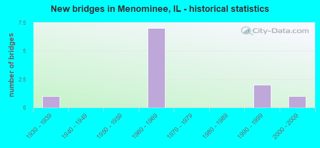
- New bridges - historical statistics
- 11930-1939
- 71960-1969
- 21990-1999
- 12000-2009


- Bridge Condition - Deck
- 44.4%Good
- 44.4%Satisfactory
- 11.1%Fair

- Bridge Condition - Superstructure
- 33.3%Good
- 55.6%Satisfactory
- 11.1%Fair

- Bridge Condition - Substructure
- 11.1%Very good
- 66.7%Good
- 11.1%Satisfactory
- 11.1%Fair

- Bridge Condition - Channel
- 11.1%Excellent
- 33.3%Very good
- 11.1%Good
- 33.3%Satisfactory
- 11.1%Fair
Find on map >> Show street view
Structure Number: 430004, Location: 4.8 MI W JCT ILL84 (Lat: 42.461767, Lng: -90.548842), Route carried "on" structure: US 20, Year Built: 1965, Year Reconstructed: 2012, Status: Open, Structure Length: 6.02m (19.75ft), Average Daily Traffic: 10,900 (year 2021), Truck Traffic: 12%, Average Future Daily Traffic: 6,600 (year 2040), Design Load: HS 20+Mod, Features Intersected: LITTLE MENOMINEE RIV
Minimum Vertical Clearance: 30+ m (98+ ft), Kilometerpoint: 10.171, Lanes on structure: 2, Base Highway Network: Yes, Owner: State Highway Agency, Approaching Roadway Width: 10.4m (34.1ft), Material/Design: Steel continuous, Design/Construction: Stringer/Multi-beam, Number Of Spans In Main Unit: 3, Length of Maximum Span: 21.9m (71.9ft), Curb-To-Curb Width: 11.9m (39.0ft), Out-to-Out Width: 11.9m (39.0ft)
Condition: Deck: Satisfactory, Superstructure: Satisfactory, Substructure: Good, Channel: Very good, Operating Rating: 97.2 metric tons, Method Used To Determine Operating Rating: Load Factor (LF) rating reported by rating factor (RF) method using MS18 loading, Inventory Rating: 60.3 metric tons, Method Used To Determine Inventory Rating: Load Factor (LF) rating reported by rating factor (RF) method using MS18 loading, Structural Evaluation: Equal to present minimum criteria, Deck Geometry: Better than present minimum criteria, Waterway Adequacy: Equal to present desirable criteria, Approach Roadway Alignment: Equal to present desirable criteria, Length Of Structure Improvement: 6.04m (19.82ft), Designated Inspection Frequency: Every 24 months, Inspection Date: September 2021, Bridge Improvement Cost: $467,000, Roadway Improvement Cost: $47,000, Total Project Cost: $701,000, Deck Structure Type: Concrete Cast-file-Place, Wearing Surface/Protective System: Deck Protection: Epoxy Coated Reinforcing
Find on map >> Show street view
Structure Number: 430005, Location: 4.8 MI W JCT ILL84 (Lat: 42.461644, Lng: -90.547706), Route carried "on" structure: US 20, Year Built: 1965, Year Reconstructed: 2012, Status: Open, Structure Length: 6.06m (19.88ft), Average Daily Traffic: 10,900 (year 2021), Truck Traffic: 12%, Average Future Daily Traffic: 6,600 (year 2040), Design Load: HS 20+Mod, Features Intersected: LITTLE MENOMINEE RIV
Minimum Vertical Clearance: 30+ m (98+ ft), Kilometerpoint: 10.267, Lanes on structure: 2, Base Highway Network: Yes, Owner: State Highway Agency, Approaching Roadway Width: 12.2m (40.0ft), Material/Design: Steel continuous, Design/Construction: Stringer/Multi-beam, Number Of Spans In Main Unit: 3, Length of Maximum Span: 21.9m (71.9ft), Curb-To-Curb Width: 9.1m (29.9ft), Out-to-Out Width: 11.9m (39.0ft)
Condition: Deck: Satisfactory, Superstructure: Satisfactory, Substructure: Good, Channel: Very good, Operating Rating: 97.2 metric tons, Method Used To Determine Operating Rating: Load Factor (LF) rating reported by rating factor (RF) method using MS18 loading, Inventory Rating: 60.3 metric tons, Method Used To Determine Inventory Rating: Load Factor (LF) rating reported by rating factor (RF) method using MS18 loading, Structural Evaluation: Equal to present minimum criteria, Deck Geometry: Meets minimum limits, Waterway Adequacy: Equal to present desirable criteria, Approach Roadway Alignment: Equal to present desirable criteria, Length Of Structure Improvement: 6.04m (19.82ft), Designated Inspection Frequency: Every 24 months, Inspection Date: September 2021, Bridge Improvement Cost: $467,000, Roadway Improvement Cost: $47,000, Total Project Cost: $701,000, Deck Structure Type: Concrete Cast-file-Place, Wearing Surface/Protective System: Deck Protection: Epoxy Coated Reinforcing
Find on map >> Show street view
Structure Number: 430006, Location: 3.2 MI W JCT ILL 84 (Lat: 42.462069, Lng: -90.516131), Route carried "on" structure: US 20, Year Built: 1968, Year Reconstructed: 2012, Status: Open, Structure Length: 3.90m (12.80ft), Average Daily Traffic: 10,900 (year 2021), Truck Traffic: 12%, Average Future Daily Traffic: 6,300 (year 2040), Design Load: HS 20+Mod, Features Intersected: MENOMINEE RD
Minimum Vertical Clearance: 30+ m (98+ ft), Kilometerpoint: 12.939, Lanes on structure: 2, Lanes under structure: 2, Base Highway Network: Yes, Owner: State Highway Agency, Approaching Roadway Width: 13.4m (44.0ft), Material/Design: Steel continuous, Design/Construction: Stringer/Multi-beam, Number Of Spans In Main Unit: 3, Length of Maximum Span: 15.8m (51.8ft), Curb-To-Curb Width: 12.2m (40.0ft), Out-to-Out Width: 13.1m (43.0ft)
Condition: Deck: Good, Superstructure: Satisfactory, Substructure: Good, Operating Rating: 86.5 metric tons, Method Used To Determine Operating Rating: Load Factor (LF) rating reported by rating factor (RF) method using MS18 loading, Inventory Rating: 51.8 metric tons, Method Used To Determine Inventory Rating: Load Factor (LF) rating reported by rating factor (RF) method using MS18 loading, Structural Evaluation: Equal to present minimum criteria, Deck Geometry: Better than present minimum criteria, Underclear: Equal to present minimum criteria, Approach Roadway Alignment: Equal to present desirable criteria, Designated Inspection Frequency: Every 24 months, Inspection Date: September 2021, Deck Structure Type: Concrete Cast-file-Place
Find on map >> Show street view
Structure Number: 430007, Location: 2.0 MI W JCT ILL84 (Lat: 42.456922, Lng: -90.493889), Route carried "on" structure: US 20, Year Built: 1966, Year Reconstructed: 2012, Status: Open, Structure Length: 6.45m (21.16ft), Average Daily Traffic: 9,400 (year 2021), Truck Traffic: 12%, Average Future Daily Traffic: 5,600 (year 2040), Design Load: HS 20+Mod, Features Intersected: SINSINAWA RIVER
Minimum Vertical Clearance: 30+ m (98+ ft), Kilometerpoint: 14.838, Lanes on structure: 2, Base Highway Network: Yes, Owner: State Highway Agency, Approaching Roadway Width: 10.7m (35.1ft), Skew: 2 degrees, Material/Design: Steel continuous, Design/Construction: Stringer/Multi-beam, Number Of Spans In Main Unit: 3, Length of Maximum Span: 23.1m (75.8ft), Curb-To-Curb Width: 10.7m (35.1ft), Out-to-Out Width: 11.6m (38.1ft)
Condition: Deck: Good, Superstructure: Satisfactory, Substructure: Good, Channel: Very good, Operating Rating: 97.2 metric tons, Method Used To Determine Operating Rating: Load Factor (LF) rating reported by rating factor (RF) method using MS18 loading, Inventory Rating: 63.8 metric tons, Method Used To Determine Inventory Rating: Load Factor (LF) rating reported by rating factor (RF) method using MS18 loading, Structural Evaluation: Equal to present minimum criteria, Deck Geometry: Somewhat better than minimum adequacy, Waterway Adequacy: Equal to present desirable criteria, Approach Roadway Alignment: Equal to present desirable criteria, Length Of Structure Improvement: 6.37m (20.90ft), Designated Inspection Frequency: Every 24 months, Inspection Date: September 2021, Bridge Improvement Cost: $492,000, Roadway Improvement Cost: $49,000, Total Project Cost: $738,000, Deck Structure Type: Concrete Cast-file-Place, Wearing Surface/Protective System: Deck Protection: Epoxy Coated Reinforcing
Find on map >> Show street view
Structure Number: 430047, Location: 2 MI. W. OF IL 84 (Lat: 42.456831, Lng: -90.493500), Route carried "on" structure: US 20, Year Built: 1993, Status: Open, Structure Length: 8.84m (29.00ft), Average Daily Traffic: 9,400 (year 2021), Truck Traffic: 12%, Average Future Daily Traffic: 5,600 (year 2040), Design Load: HS 20+Mod, Features Intersected: SINSINAWA RIVER
Minimum Vertical Clearance: 30+ m (98+ ft), Kilometerpoint: 14.870, Lanes on structure: 2, Base Highway Network: Yes, Owner: State Highway Agency, Approaching Roadway Width: 11.6m (38.1ft), Skew: 3 degrees, Material/Design: Steel continuous, Design/Construction: Stringer/Multi-beam, Number Of Spans In Main Unit: 2, Length of Maximum Span: 44.2m (145.0ft), Curb-To-Curb Width: 11.6m (38.1ft), Out-to-Out Width: 12.6m (41.3ft)
Condition: Deck: Satisfactory, Superstructure: Satisfactory, Substructure: Good, Channel: Satisfactory, Operating Rating: 85.5 metric tons, Method Used To Determine Operating Rating: Load Factor (LF) rating reported by rating factor (RF) method using MS18 loading, Inventory Rating: 51.5 metric tons, Method Used To Determine Inventory Rating: Load Factor (LF) rating reported by rating factor (RF) method using MS18 loading, Structural Evaluation: Equal to present minimum criteria, Deck Geometry: Better than present minimum criteria, Waterway Adequacy: Superior to present desirable criteria, Approach Roadway Alignment: Equal to present desirable criteria, Designated Inspection Frequency: Every 24 months, Inspection Date: September 2021, Deck Structure Type: Concrete Cast-file-Place, Wearing Surface/Protective System: Deck Protection: Epoxy Coated Reinforcing
Find on map >> Show street view
Structure Number: 433006, Location: MENOMINEE (Lat: 42.487264, Lng: -90.532317), Route carried "on" structure: County highway , Year Built: 1932, Status: Open, Structure Length: 1.52m (4.99ft), Average Daily Traffic: 550 (year 2021), Truck Traffic: 9%, Average Future Daily Traffic: 600 (year 2040), Features Intersected: LITTLE MENOMINEE RIV, Facility Carried by Structure: NORTH MENOMINEE RO
Minimum Vertical Clearance: 30+ m (98+ ft), Kilometerpoint: 2.945, Lanes on structure: 2, Owner: County Highway Agency, Approaching Roadway Width: 9.1m (29.9ft), Skew: 4 degrees, Material/Design: Concrete, Number Of Spans In Main Unit: 1, Length of Maximum Span: 14.9m (48.9ft), Curb-To-Curb Width: 6.1m (20.0ft), Out-to-Out Width: 7.4m (24.3ft)
Condition: Deck: Fair, Superstructure: Fair, Substructure: Satisfactory, Channel: Fair, Operating Rating: 21.7 metric tons, Method Used To Determine Operating Rating: Load Factor (LF) rating reported by rating factor (RF) method using MS18 loading, Inventory Rating: 13.0 metric tons, Method Used To Determine Inventory Rating: Load Factor (LF) rating reported by rating factor (RF) method using MS18 loading, Structural Evaluation: Meets minimum limits, Deck Geometry: High priority of corrective action, Waterway Adequacy: Better than present minimum criteria, Approach Roadway Alignment: Meets minimum limits, Length Of Structure Improvement: 2.29m (7.51ft), Designated Inspection Frequency: Every 24 months, Inspection Date: October 2020, Bridge Improvement Cost: $106,000, Roadway Improvement Cost: $11,000, Total Project Cost: $159,000, Deck Structure Type: Concrete Cast-file-Place, Wearing Surface/Protective System: Wearing Surface: Bituminous
Find on map >> Show street view
Structure Number: 433041, Location: 1 MI NE MENOMINEE (Lat: 42.496836, Lng: -90.523728), Route carried "on" structure: County highway , Year Built: 1964, Status: Open, Structure Length: 1.80m (5.91ft), Average Daily Traffic: 100 (year 2021), Truck Traffic: 24%, Average Future Daily Traffic: 100 (year 2040), Design Load: HS 15, Features Intersected: L. MENOMINEE RIV, Facility Carried by Structure: TOWNSHIP ROAD NO.
Minimum Vertical Clearance: 30+ m (98+ ft), Kilometerpoint: 0.756, Lanes on structure: 1, Owner: Town or Township Highway Agency, Approaching Roadway Width: 6.7m (22.0ft), Material/Design: Steel, Design/Construction: Stringer/Multi-beam, Number Of Spans In Main Unit: 1, Length of Maximum Span: 17.7m (58.1ft), Curb-To-Curb Width: 6.1m (20.0ft), Out-to-Out Width: 6.9m (22.6ft)
Condition: Deck: Good, Superstructure: Good, Substructure: Fair, Channel: Good, Operating Rating: 43.4 metric tons, Method Used To Determine Operating Rating: Allowable Stress (AS) rating reported by rating factor (RF) method using MS18 loading, Inventory Rating: 25.9 metric tons, Method Used To Determine Inventory Rating: Allowable Stress (AS) rating reported by rating factor (RF) method using MS18 loading, Structural Evaluation: Somewhat better than minimum adequacy, Deck Geometry: Somewhat better than minimum adequacy, Waterway Adequacy: Better than present minimum criteria, Approach Roadway Alignment: Somewhat better than minimum adequacy, Length Of Structure Improvement: 2.53m (8.30ft), Designated Inspection Frequency: Every 24 months, Inspection Date: October 2020, Bridge Improvement Cost: $141,000, Roadway Improvement Cost: $14,000, Total Project Cost: $212,000, Deck Structure Type: Concrete Cast-file-Place
Find on map >> Show street view
Structure Number: 433042, Location: 3 M E MENOMINEE (Lat: 42.478875, Lng: -90.486514), Route carried "on" structure: County highway , Year Built: 1964, Status: Open, Structure Length: 2.10m (6.89ft), Average Daily Traffic: 700 (year 2021), Truck Traffic: 34%, Average Future Daily Traffic: 550 (year 2040), Design Load: HS 15, Features Intersected: SINSINAWA RIVER, Facility Carried by Structure: TOWNSHIP ROAD NO.
Minimum Vertical Clearance: 30+ m (98+ ft), Kilometerpoint: 5.456, Lanes on structure: 1, Owner: Town or Township Highway Agency, Approaching Roadway Width: 6.1m (20.0ft), Material/Design: Steel, Design/Construction: Stringer/Multi-beam, Number Of Spans In Main Unit: 1, Length of Maximum Span: 20.4m (66.9ft), Curb-To-Curb Width: 6.1m (20.0ft), Out-to-Out Width: 6.9m (22.6ft)
Condition: Deck: Satisfactory, Superstructure: Good, Substructure: Good, Channel: Satisfactory, Operating Rating: 40.8 metric tons, Method Used To Determine Operating Rating: Load Factor (LF) rating reported by rating factor (RF) method using MS18 loading, Inventory Rating: 24.6 metric tons, Method Used To Determine Inventory Rating: Load Factor (LF) rating reported by rating factor (RF) method using MS18 loading, Structural Evaluation: Equal to present minimum criteria, Deck Geometry: High priority of corrective action, Waterway Adequacy: Better than present minimum criteria, Approach Roadway Alignment: Somewhat better than minimum adequacy, Designated Inspection Frequency: Every 24 months, Inspection Date: October 2020, Deck Structure Type: Concrete Cast-file-Place
Find on map >> Show street view
Structure Number: 43324, Location: 2.5 MI E MENOMINEE (Lat: 42.484800, Lng: -90.485694), Route carried "on" structure: County highway , Year Built: 1990, Status: Open, Structure Length: 3.74m (12.27ft), Average Daily Traffic: 100 (year 2021), Truck Traffic: 14%, Average Future Daily Traffic: 25 (year 2040), Design Load: HS 20, Features Intersected: SINSINAWA RIVER, Facility Carried by Structure: W. VALLEY RD (TR9)
Minimum Vertical Clearance: 30+ m (98+ ft), Kilometerpoint: 3.380, Lanes on structure: 2, Owner: Town or Township Highway Agency, Approaching Roadway Width: 6.1m (20.0ft), Skew: 2 degrees, Material/Design: Prestressed concrete, Design/Construction: Box Beam or Girders - Multiple, Number Of Spans In Main Unit: 3, Length of Maximum Span: 12.6m (41.3ft), Curb-To-Curb Width: 7.3m (24.0ft), Out-to-Out Width: 7.3m (24.0ft)
Condition: Deck: Good, Superstructure: Good, Substructure: Very good, Channel: Satisfactory, Operating Rating: 44.4 metric tons, Method Used To Determine Operating Rating: Assigned rating based on Load Factor Design (LFD) reported by rating factor (RF) using MS18 loading, Inventory Rating: 32.4 metric tons, Method Used To Determine Inventory Rating: Assigned rating based on Load Factor Design (LFD) reported by rating factor (RF) using MS18 loading, Structural Evaluation: Better than present minimum criteria, Deck Geometry: Equal to present minimum criteria, Waterway Adequacy: Equal to present minimum criteria, Approach Roadway Alignment: High priority of corrective action, Designated Inspection Frequency: Every 48 months, Inspection Date: Febuary 2021, Deck Structure Type: Concrete Precast Panels
Find on map >> Show street view
Structure Number: 433267, Location: 1MI NW OF MENOMINEE (Lat: 42.502547, Lng: -90.553992), Route carried "on" structure: County highway , Year Built: 2006, Status: Open, Structure Length: 0.85m (2.79ft), Average Daily Traffic: 700 (year 2021), Truck Traffic: 27%, Average Future Daily Traffic: 550 (year 2040), Design Load: HS 20, Features Intersected: TRIB MENOMINEE RVR, Facility Carried by Structure: RTE 5 WEST
Minimum Vertical Clearance: 30+ m (98+ ft), Kilometerpoint: 5.391, Lanes on structure: 2, Owner: Town or Township Highway Agency, Approaching Roadway Width: 6.7m (22.0ft), Material/Design: Concrete, Design/Construction: Culvert, Number Of Spans In Main Unit: 2, Length of Maximum Span: 0.9m (3.0ft)
Condition: Channel: Excellent, Culverts: Very good, Operating Rating: 44.1 metric tons, Method Used To Determine Operating Rating: Assigned rating based on Load Factor Design (LFD) reported by rating factor (RF) using MS18 loading, Inventory Rating: 32.4 metric tons, Method Used To Determine Inventory Rating: Assigned rating based on Load Factor Design (LFD) reported by rating factor (RF) using MS18 loading, Structural Evaluation: Equal to present desirable criteria, Waterway Adequacy: Superior to present desirable criteria, Approach Roadway Alignment: Better than present minimum criteria, Designated Inspection Frequency: Every 48 months, Inspection Date: October 2018
Find on map >> Show street view
Structure Number: 430006, Location: 3.2 MI W JCT ILL 84 (Lat: 42.462361, Lng: -90.515789), Route carried "under" structure: County highway , Year Built: 1968, Structure Length: 0. m, Average Daily Traffic: 750 (year 2021), Truck Traffic: 8%, Features Intersected: MENOMINEE RD, Facility Carried by Structure: US 20 WB
Minimum Vertical Clearance: 4.78m (15.68ft), Kilometerpoint: 6.823, Lanes on structure: 2, Lanes under structure: 2, Material/Design: Steel continuous, Design/Construction: Stringer/Multi-beam, Length of Maximum Span: 15.8m (51.8ft)