Bridge Statistics for Memphis, Michigan (MI)
Condition, Traffic, Stress, Structural Evaluation, Project Costs
- National Bridge Inventory (NBI) Statistics
- 11Number of bridges
- 49ft / 15.1mTotal length
- $336,000Total costs
- 14,308Total average daily traffic
- 613Total average daily truck traffic
- 22,811Total future (year 2014) average daily traffic
- National Bridge Inventory (NBI) Registered Bridges for Memphis
- No street view available for this location
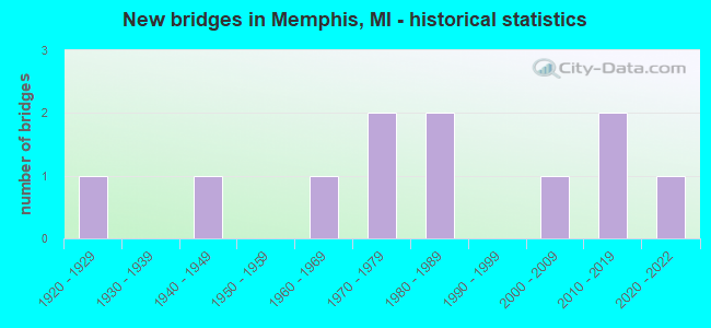
- New bridges - historical statistics
- 11920-1929
- 11940-1949
- 11960-1969
- 21970-1979
- 21980-1989
- 12000-2009
- 22010-2019
- 12020-2022


- Bridge Condition - Deck
- 60.0%Good
- 20.0%Fair
- 20.0%Poor

- Bridge Condition - Superstructure
- 40.0%Very good
- 20.0%Good
- 20.0%Fair
- 20.0%Serious

- Bridge Condition - Substructure
- 20.0%Good
- 60.0%Satisfactory
- 20.0%Fair

- Bridge Condition - Channel
- 18.2%Good
- 54.5%Satisfactory
- 18.2%Fair
- 9.1%Poor

- Bridge Condition - Culverts
- 16.7%Excellent
- 33.3%Very good
- 16.7%Good
- 16.7%Satisfactory
- 16.7%Poor
Find on map >> Show street view
Structure Number: 6132, Location: 1.0 MI S OF MEMPHIS (Lat: 42.882861, Lng: -82.768192), Route carried "on" structure: State highway 19, Year Built: 1928, Year Reconstructed: 2000, Status: Open, Structure Length: 1.41m (4.63ft), Average Daily Traffic: 7,023 (year 2007), Truck Traffic: 4%, Average Future Daily Traffic: 13,445 (year 2018), Design Load: HS 25 or greater, Features Intersected: ASHERY CREEK
Minimum Vertical Clearance: 30.48m (100.00ft), Kilometerpoint: 10.619, Lanes on structure: 2, Base Highway Network: Yes (Inventory Route: 81, Subroute: 4), Owner: State Highway Agency, Approaching Roadway Width: 13.4m (44.0ft), Material/Design: Prestressed concrete, Design/Construction: Box Beam or Girders - Single/Spread, Number Of Spans In Main Unit: 1, Length of Maximum Span: 13.4m (44.0ft), Curb-To-Curb Width: 13.2m (43.3ft), Out-to-Out Width: 14.2m (46.6ft)
Condition: Deck: Good, Superstructure: Very good, Substructure: Satisfactory, Channel: Satisfactory, Operating Rating: 61.6 metric tons, Method Used To Determine Operating Rating: Load and Resistance Factor Rating (LRFR) rating reported by rating factor(RF) method using HL-93 loadings, Inventory Rating: 47.3 metric tons, Method Used To Determine Inventory Rating: Load and Resistance Factor Rating (LRFR) rating reported by rating factor(RF) method using HL-93 loadings, Structural Evaluation: Equal to present minimum criteria, Deck Geometry: Somewhat better than minimum adequacy, Waterway Adequacy: Better than present minimum criteria, Approach Roadway Alignment: Better than present minimum criteria, Designated Inspection Frequency: Every 24 months, Inspection Date: April 2020, Deck Structure Type: Concrete Cast-file-Place, Wearing Surface/Protective System: Wearing Surface: Monolithic Concrete, Deck Protection: Epoxy Coated Reinforcing
Find on map >> Show street view
Structure Number: 6393, Location: 1.3 MILES EAST OF M-19 (Lat: 42.875761, Lng: -82.741450), Route carried "on" structure: County highway , Year Built: 2002, Status: Open, Structure Length: 3.66m (12.01ft), Average Daily Traffic: 270 (year 2006), Truck Traffic: 3%, Average Future Daily Traffic: 443 (year 2026), Design Load: HS 20, Features Intersected: BELLE RIVER, Facility Carried by Structure: WEBER ROAD
Minimum Vertical Clearance: 30.48m (100.00ft), Kilometerpoint: 6.611, Lanes on structure: 2, Owner: County Highway Agency, Approaching Roadway Width: 12.2m (40.0ft), Skew: 3 degrees, Material/Design: Prestressed concrete, Design/Construction: Stringer/Multi-beam, Number Of Spans In Main Unit: 2, Length of Maximum Span: 18.3m (60.0ft), Curb-To-Curb Width: 12.2m (40.0ft), Out-to-Out Width: 14.4m (47.2ft)
Condition: Deck: Good, Superstructure: Very good, Substructure: Good, Channel: Good, Operating Rating: 68.7 metric tons, Method Used To Determine Operating Rating: Load Factor (LF) rating reported by rating factor (RF) method using MS18 loading, Inventory Rating: 41.8 metric tons, Method Used To Determine Inventory Rating: Load Factor (LF) rating reported by rating factor (RF) method using MS18 loading, Structural Evaluation: Better than present minimum criteria, Deck Geometry: Superior to present desirable criteria, Waterway Adequacy: Superior to present desirable criteria, Approach Roadway Alignment: Equal to present desirable criteria, Designated Inspection Frequency: Every 24 months, Underwater Inspection Frequency: Every 60 months, Inspection Date: June 2021, Underwater Inspection Date: August 2018, Deck Structure Type: Concrete Precast Panels, Wearing Surface/Protective System: Wearing Surface: Monolithic Concrete, Deck Protection: Epoxy Coated Reinforcing
Find on map >> Show street view
Structure Number: 6394, Location: 660 FT WEST OF M-19 (Lat: 42.875594, Lng: -82.771128), Route carried "on" structure: County highway , Year Built: 1970, Status: Open, Structure Length: 0.91m (2.99ft), Average Daily Traffic: 160 (year 2006), Truck Traffic: 2%, Average Future Daily Traffic: 238 (year 2026), Design Load: H 20, Features Intersected: BEAVER CREEK, Facility Carried by Structure: WEBER ROAD
Minimum Vertical Clearance: 30.48m (100.00ft), Kilometerpoint: 4.201, Lanes on structure: 2, Owner: County Highway Agency, Approaching Roadway Width: 7.0m (23.0ft), Material/Design: Steel, Design/Construction: Culvert, Number Of Spans In Main Unit: 2, Length of Maximum Span: 3.9m (12.8ft)
Condition: Channel: Satisfactory, Culverts: Good, Operating Rating: 97.2 metric tons, Method Used To Determine Operating Rating: Load Factor (LF) rating reported by rating factor (RF) method using MS18 loading, Inventory Rating: 96.9 metric tons, Method Used To Determine Inventory Rating: Load Factor (LF) rating reported by rating factor (RF) method using MS18 loading, Structural Evaluation: Better than present minimum criteria, Waterway Adequacy: Better than present minimum criteria, Approach Roadway Alignment: Better than present minimum criteria, Designated Inspection Frequency: Every 24 months, Inspection Date: June 2021
Find on map >> Show street view
Structure Number: 10052, Location: SEC. 36 RILEY TWP. (Lat: 42.896844, Lng: -82.758297), Route carried "on" structure: County highway 7756, Year Built: 1968, Status: Open, Structure Length: 2.13m (6.99ft), Average Daily Traffic: 2,410 (year 1994), Truck Traffic: 5%, Average Future Daily Traffic: 2,710 (year 2014), Design Load: HS 20+Mod, Features Intersected: BELLE RIVER, Facility Carried by Structure: BORDMAN ROAD
Minimum Vertical Clearance: 30.48m (100.00ft), Kilometerpoint: 13.107, Lanes on structure: 2, Owner: County Highway Agency, Approaching Roadway Width: 12.2m (40.0ft), Material/Design: Prestressed concrete, Design/Construction: Box Beam or Girders - Multiple, Number Of Spans In Main Unit: 1, Length of Maximum Span: 20.7m (67.9ft), Curb or Sidewalk Widths: Left: 0.6m (2.0ft), Right: 0.6m (2.0ft), Curb-To-Curb Width: 8.5m (27.9ft), Out-to-Out Width: 10.1m (33.1ft)
Condition: Deck: Good, Superstructure: Good, Substructure: Satisfactory, Channel: Satisfactory, Operating Rating: 96.2 metric tons, Method Used To Determine Operating Rating: Load Factor (LF) rating reported by rating factor (RF) method using MS18 loading, Inventory Rating: 53.5 metric tons, Method Used To Determine Inventory Rating: Load Factor (LF) rating reported by rating factor (RF) method using MS18 loading, Structural Evaluation: Equal to present minimum criteria, Deck Geometry: Meets minimum limits, Waterway Adequacy: Equal to present desirable criteria, Approach Roadway Alignment: Equal to present desirable criteria, Designated Inspection Frequency: Every 24 months, Inspection Date: January 2021, Roadway Improvement Cost: $10,000, Total Project Cost: $12,000, Deck Structure Type: Concrete Cast-file-Place, Wearing Surface/Protective System: Wearing Surface: Bituminous
Find on map >> Show street view
Structure Number: 10055, Location: SEC 34 RILEY TWP (Lat: 42.895836, Lng: -82.792839), Route carried "on" structure: County highway 7798, Year Built: 1989, Status: Open, Structure Length: 1.12m (3.67ft), Average Daily Traffic: 1,300 (year 1994), Truck Traffic: 5%, Average Future Daily Traffic: 1,550 (year 2014), Design Load: HS 20+Mod, Features Intersected: SHAFER DRAIN EXTENSION, Facility Carried by Structure: BORDMAN ROAD
Minimum Vertical Clearance: 30.48m (100.00ft), Kilometerpoint: 10.284, Lanes on structure: 2, Base Highway Network: Yes (Inventory Route: 82, Subroute: 10), Owner: County Highway Agency, Approaching Roadway Width: 7.9m (25.9ft), Skew: 4 degrees, Material/Design: Concrete, Design/Construction: Culvert, Number Of Spans In Main Unit: 1, Length of Maximum Span: 10.3m (33.8ft), Curb-To-Curb Width: 10.3m (33.8ft), Out-to-Out Width: 10.7m (35.1ft)
Condition: Channel: Satisfactory, Culverts: Satisfactory, Operating Rating: 49.2 metric tons, Method Used To Determine Operating Rating: Load Factor (LF) rating reported by rating factor (RF) method using MS18 loading, Inventory Rating: 29.5 metric tons, Method Used To Determine Inventory Rating: Load Factor (LF) rating reported by rating factor (RF) method using MS18 loading, Structural Evaluation: Equal to present minimum criteria, Deck Geometry: Somewhat better than minimum adequacy, Waterway Adequacy: Equal to present desirable criteria, Approach Roadway Alignment: Equal to present desirable criteria, Designated Inspection Frequency: Every 24 months, Inspection Date: January 2021, Deck Structure Type: Concrete Cast-file-Place, Wearing Surface/Protective System: Wearing Surface: Bituminous
Find on map >> Show street view
Structure Number: 10089, Location: SEC. 17 COLUMBUS TWP. (Lat: 42.868983, Lng: -82.708933), Route carried "on" structure: County highway , Year Built: 1982, Status: Open, Structure Length: 0.64m (2.10ft), Average Daily Traffic: 2,160 (year 1994), Truck Traffic: 5%, Average Future Daily Traffic: 3,000 (year 2014), Design Load: HS 20, Features Intersected: TINSMAN DRAIN, Facility Carried by Structure: BAUMAN ROAD
Minimum Vertical Clearance: 30.48m (100.00ft), Kilometerpoint: 5.076, Lanes on structure: 2, Owner: County Highway Agency, Approaching Roadway Width: 9.7m (31.8ft), Material/Design: Steel, Design/Construction: Culvert, Number Of Spans In Main Unit: 2, Length of Maximum Span: 3.0m (9.8ft)
Condition: Channel: Satisfactory, Culverts: Poor, Operating Rating: 55.7 metric tons, Method Used To Determine Operating Rating: Load and Resistance Factor Rating (LRFR) rating reported by rating factor(RF) method using HL-93 loadings, Inventory Rating: 43.1 metric tons, Method Used To Determine Inventory Rating: Load and Resistance Factor Rating (LRFR) rating reported by rating factor(RF) method using HL-93 loadings, Structural Evaluation: Meets minimum limits, Waterway Adequacy: Equal to present desirable criteria, Approach Roadway Alignment: Equal to present minimum criteria, Designated Inspection Frequency: Every 12 months, Inspection Date: January 2022, Roadway Improvement Cost: $10,000, Total Project Cost: $12,000, Wearing Surface/Protective System: Wearing Surface: Bituminous
Find on map >> Show street view
Structure Number: 10151, Location: SEC. 8-17 COLUMBUS TWP. (Lat: 42.870722, Lng: -82.703417), Route carried "on" structure: ServiceCounty highway , Year Built: 2016, Status: Open, Structure Length: 1.37m (4.49ft), Average Daily Traffic: 200 (year 2015), Truck Traffic: 4%, Average Future Daily Traffic: 250 (year 2035), Design Load: H 20, Features Intersected: TINSMAN DRAIN, Facility Carried by Structure: MESKILL ROAD
Minimum Vertical Clearance: 30.48m (100.00ft), Kilometerpoint: 1.803, Lanes on structure: 2, Owner: County Highway Agency, Approaching Roadway Width: 6.7m (22.0ft), Material/Design: Aluminum, Iron, Design/Construction: Culvert, Number Of Spans In Main Unit: 1, Length of Maximum Span: 6.5m (21.3ft), Curb or Sidewalk Widths: Left: 0.0m, Right: 8.5m (27.9ft), Curb-To-Curb Width: 8.5m (27.9ft), Out-to-Out Width: 8.5m (27.9ft)
Condition: Channel: Fair, Culverts: Very good, Operating Rating: 58.0 metric tons, Method Used To Determine Operating Rating: Load and Resistance Factor Rating (LRFR) rating reported by rating factor(RF) method using HL-93 loadings, Inventory Rating: 34.7 metric tons, Method Used To Determine Inventory Rating: Load and Resistance Factor Rating (LRFR) rating reported by rating factor(RF) method using HL-93 loadings, Structural Evaluation: Equal to present desirable criteria, Deck Geometry: Equal to present minimum criteria, Waterway Adequacy: Meets minimum limits, Approach Roadway Alignment: Equal to present desirable criteria, Designated Inspection Frequency: Every 24 months, Inspection Date: December 2020, Deck Structure Type: Concrete Cast-file-Place, Wearing Surface/Protective System: Wearing Surface: Monolithic Concrete
Find on map >> Show street view
Structure Number: 1022, Location: SEC 28-33 RILEY TWP (Lat: 42.910292, Lng: -82.816250), Route carried "on" structure: ServiceCounty highway , Year Built: 2020, Status: Open, Structure Length: 0.66m (2.17ft), Average Future Daily Traffic: 200 (year 2039), Design Load: Greater than HL93, Features Intersected: SHARRARD-BURGESS DRAIN, Facility Carried by Structure: HOUGH ROAD
Minimum Vertical Clearance: 30.48m (100.00ft), Kilometerpoint: 14.129, Lanes on structure: 2, Owner: County Highway Agency, Approaching Roadway Width: 7.3m (24.0ft), Skew: 1 degrees, Material/Design: Aluminum, Iron, Design/Construction: Culvert, Number Of Spans In Main Unit: 1, Length of Maximum Span: 6.6m (21.7ft), Curb-To-Curb Width: 8.5m (27.9ft), Out-to-Out Width: 10.1m (33.1ft)
Condition: Channel: Satisfactory, Culverts: Excellent, Operating Rating: 85.9 metric tons, Method Used To Determine Operating Rating: Load and Resistance Factor Rating (LRFR) rating reported by rating factor(RF) method using HL-93 loadings, Inventory Rating: 59.0 metric tons, Method Used To Determine Inventory Rating: Load and Resistance Factor Rating (LRFR) rating reported by rating factor(RF) method using HL-93 loadings, Structural Evaluation: Superior to present desirable criteria, Deck Geometry: Better than present minimum criteria, Waterway Adequacy: Better than present minimum criteria, Approach Roadway Alignment: Better than present minimum criteria, Designated Inspection Frequency: Every 24 months, Inspection Date: July 2020, Roadway Improvement Cost: $6,000, Total Project Cost: $7,000, Deck Structure Type: Concrete Cast-file-Place, Wearing Surface/Protective System: Wearing Surface: Monolithic Concrete, Deck Protection: Epoxy Coated Reinforcing
Find on map >> Show street view
Structure Number: 10222, Location: SEC. 33-34 RILEY TWP. (Lat: 42.906433, Lng: -82.800011), Route carried "on" structure: ServiceCounty highway , Year Built: 1970, Status: Posted for load, Structure Length: 0.67m (2.20ft), Average Daily Traffic: 310 (year 1994), Truck Traffic: 3%, Average Future Daily Traffic: 410 (year 2014), Design Load: H 20, Features Intersected: SHARRARD-BURGESS DRAIN, Facility Carried by Structure: BRAIDWOOD ROAD
Minimum Vertical Clearance: 30.48m (100.00ft), Kilometerpoint: 1.189, Lanes on structure: 2, Owner: County Highway Agency, Approaching Roadway Width: 6.1m (20.0ft), Material/Design: Prestressed concrete, Design/Construction: Box Beam or Girders - Multiple, Number Of Spans In Main Unit: 1, Length of Maximum Span: 6.4m (21.0ft), Curb-To-Curb Width: 4.5m (14.8ft), Out-to-Out Width: 4.5m (14.8ft)
Condition: Deck: Poor, Superstructure: Serious, Substructure: Fair, Channel: Poor, Operating Rating: 12.3 metric tons, Method Used To Determine Operating Rating: Load Factor (LF) rating reported by rating factor (RF) method using MS18 loading, Inventory Rating: 7.1 metric tons, Method Used To Determine Inventory Rating: Load Factor (LF) rating reported by rating factor (RF) method using MS18 loading, Structural Evaluation: High priority of replacement, Deck Geometry: High priority of replacement, Waterway Adequacy: Meets minimum limits, Approach Roadway Alignment: Somewhat better than minimum adequacy, Bridge Posting: Required (Relationship of Operating Rating to Maximum Legal Load: 20.0 - 29.9% below), Length Of Structure Improvement: 1.22m (4.00ft), Designated Inspection Frequency: Every 12 months, Inspection Date: January 2022, Bridge Improvement Cost: $168,000, Roadway Improvement Cost: $15,000, Total Project Cost: $250,000, Deck Structure Type: Concrete Cast-file-Place, Wearing Surface/Protective System: Wearing Surface: Monolithic Concrete
Find on map >> Show street view
Structure Number: 10223, Location: SEC. 27-28 RILEY TWP. (Lat: 42.916147, Lng: -82.800469), Route carried "on" structure: ServiceCounty highway , Year Built: 1940, Status: Posted for load, Structure Length: 1.86m (6.10ft), Average Daily Traffic: 430 (year 1994), Truck Traffic: 3%, Average Future Daily Traffic: 500 (year 2014), Design Load: H 20, Features Intersected: BELLE RIVER, Facility Carried by Structure: BRAIDWOOD ROAD
Minimum Vertical Clearance: 30.48m (100.00ft), Kilometerpoint: 2.269, Lanes on structure: 2, Owner: County Highway Agency, Approaching Roadway Width: 9.1m (29.9ft), Material/Design: Steel, Design/Construction: Stringer/Multi-beam, Number Of Spans In Main Unit: 1, Length of Maximum Span: 17.6m (57.7ft), Curb-To-Curb Width: 7.3m (24.0ft), Out-to-Out Width: 8.2m (26.9ft)
Condition: Deck: Fair, Superstructure: Fair, Substructure: Satisfactory, Channel: Fair, Operating Rating: 49.6 metric tons, Method Used To Determine Operating Rating: Load Factor (LF) rating reported by rating factor (RF) method using MS18 loading, Inventory Rating: 29.5 metric tons, Method Used To Determine Inventory Rating: Load Factor (LF) rating reported by rating factor (RF) method using MS18 loading, Structural Evaluation: Somewhat better than minimum adequacy, Deck Geometry: Meets minimum limits, Waterway Adequacy: Equal to present minimum criteria, Approach Roadway Alignment: Equal to present desirable criteria, Bridge Posting: Required (Relationship of Operating Rating to Maximum Legal Load: 10.0 - 19.9% below), Length Of Structure Improvement: 7.93m (26.02ft), Designated Inspection Frequency: Every 24 months, Underwater Inspection Frequency: Every 60 months, Inspection Date: January 2021, Underwater Inspection Date: October 2017, Bridge Improvement Cost: $37,000, Roadway Improvement Cost: $15,000, Total Project Cost: $55,000, Deck Structure Type: Concrete Cast-file-Place, Wearing Surface/Protective System: Wearing Surface: Monolithic Concrete
Find on map >> Show street view
Structure Number: 10239, Location: SEC 19-20 WALES TWP (Lat: 42.937239, Lng: -82.723247), Route carried "on" structure: ServiceCounty highway , Year Built: 2019, Status: Open, Structure Length: 0.63m (2.07ft), Average Daily Traffic: 45 (year 1994), Average Future Daily Traffic: 65 (year 2014), Design Load: Greater than HL93, Features Intersected: UNNAMED CREEK, Facility Carried by Structure: FOX ROAD
Minimum Vertical Clearance: 30.48m (100.00ft), Kilometerpoint: 0.673, Lanes on structure: 2, Owner: County Highway Agency, Approaching Roadway Width: 8.5m (27.9ft), Material/Design: Aluminum, Iron, Design/Construction: Culvert, Number Of Spans In Main Unit: 1, Length of Maximum Span: 6.3m (20.7ft), Curb-To-Curb Width: 11.0m (36.1ft), Out-to-Out Width: 11.0m (36.1ft)
Condition: Channel: Good, Culverts: Very good, Operating Rating: 79.1 metric tons, Method Used To Determine Operating Rating: Load and Resistance Factor Rating (LRFR) rating reported by rating factor(RF) method using HL-93 loadings, Inventory Rating: 60.9 metric tons, Method Used To Determine Inventory Rating: Load and Resistance Factor Rating (LRFR) rating reported by rating factor(RF) method using HL-93 loadings, Structural Evaluation: Equal to present desirable criteria, Deck Geometry: Superior to present desirable criteria, Waterway Adequacy: Better than present minimum criteria, Approach Roadway Alignment: Equal to present desirable criteria, Designated Inspection Frequency: Every 24 months, Inspection Date: January 2022, Wearing Surface/Protective System: Wearing Surface: Bituminous