Bridge Statistics for Mead, Colorado (CO)
Condition, Traffic, Stress, Structural Evaluation, Project Costs
- National Bridge Inventory (NBI) Statistics
- 24Number of bridges
- 217ft / 66.5mTotal length
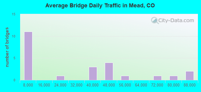
- 662,865Total average daily traffic
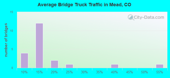
- 75,482Total average daily truck traffic
- National Bridge Inventory (NBI) Registered Bridges for Mead
- No street view available for this location
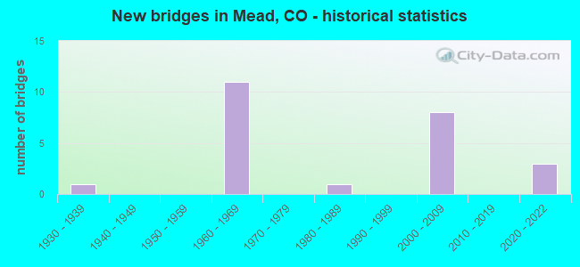
- New bridges - historical statistics
- 11930-1939
- 111960-1969
- 11980-1989
- 82000-2009
- 32020-2022
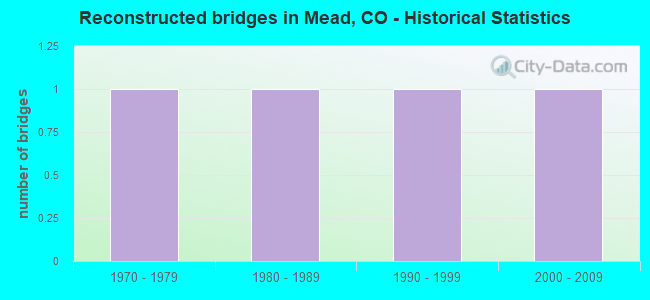
- Reconstructed bridges - Historical Statistics
- 11970-1979
- 11980-1989
- 11990-1999
- 12000-2009
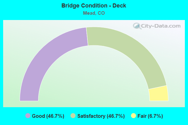
- Bridge Condition - Deck
- 46.7%Good
- 46.7%Satisfactory
- 6.7%Fair
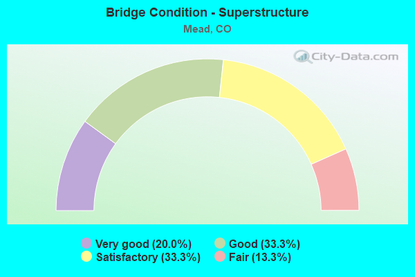
- Bridge Condition - Superstructure
- 20.0%Very good
- 33.3%Good
- 33.3%Satisfactory
- 13.3%Fair
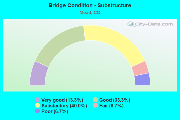
- Bridge Condition - Substructure
- 13.3%Very good
- 33.3%Good
- 40.0%Satisfactory
- 6.7%Fair
- 6.7%Poor
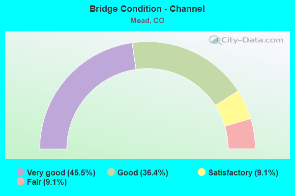
- Bridge Condition - Channel
- 45.5%Very good
- 36.4%Good
- 9.1%Satisfactory
- 9.1%Fair
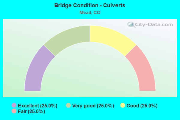
- Bridge Condition - Culverts
- 25.0%Excellent
- 25.0%Very good
- 25.0%Good
- 25.0%Fair
Find on map >> Show street view
Structure Number: D-17-CR, Location: 4.0 MI N OF WELD-ADAMS CL (Lat: 40.058242, Lng: -104.980156), Route carried "on" structure: Interstate 25A, Year Built: 2004, Status: Open, Structure Length: 3.93m (12.89ft), Average Daily Traffic: 51,000 (year 2020), Truck Traffic: 9%, Average Future Daily Traffic: 73,950 (year 2040), Design Load: HL 93, Features Intersected: COUNTY ROAD, Facility Carried by Structure: I 25 ML NBND
Minimum Vertical Clearance: 30+ m (98+ ft), Kilometerpoint: 374.824, Lanes on structure: 3, Lanes under structure: 2, Base Highway Network: Yes, Owner: State Highway Agency, Approaching Roadway Width: 19.5m (64.0ft), Material/Design: Prestressed concrete, Design/Construction: Box Beam or Girders - Multiple, Number Of Spans In Main Unit: 1, Length of Maximum Span: 38.1m (125.0ft), Curb-To-Curb Width: 19.5m (64.0ft), Out-to-Out Width: 20.4m (66.9ft)
Condition: Deck: Good, Superstructure: Good, Substructure: Good, Operating Rating: 45.4 metric tons, Method Used To Determine Operating Rating: Load and Resistance Factor Rating (LRFR) rating reported by rating factor(RF) method using HL-93 loadings, Inventory Rating: 35.6 metric tons, Method Used To Determine Inventory Rating: Load and Resistance Factor Rating (LRFR) rating reported by rating factor(RF) method using HL-93 loadings, Structural Evaluation: Better than present minimum criteria, Deck Geometry: Superior to present desirable criteria, Underclear: Equal to present minimum criteria, Approach Roadway Alignment: Equal to present desirable criteria, Designated Inspection Frequency: Every 24 months, Inspection Date: June 2021, Deck Structure Type: Concrete Cast-file-Place, Wearing Surface/Protective System: Wearing Surface: Bituminous, Membrane: Preformed Fabric, Deck Protection: Epoxy Coated Reinforcing
Find on map >> Show street view
Structure Number: D-17-CY, Location: 6 MI SO OF JCT SH 56 (Lat: 40.218875, Lng: -104.980117), Route carried "on" structure: Interstate 25A, Year Built: 1961, Status: Open, Structure Length: 2.85m (9.35ft), Average Daily Traffic: 37,000 (year 2020), Truck Traffic: 10%, Average Future Daily Traffic: 54,760 (year 2040), Design Load: HS 20, Features Intersected: COUNTY ROAD 32, Facility Carried by Structure: I 25 ML SBND
Minimum Vertical Clearance: 30+ m (98+ ft), Kilometerpoint: 392.638, Lanes on structure: 2, Lanes under structure: 2, Base Highway Network: Yes, Owner: State Highway Agency, Approaching Roadway Width: 11.6m (38.1ft), Skew: 10 degrees, Material/Design: Concrete, Design/Construction: Tee Beam, Number Of Spans In Main Unit: 3, Length of Maximum Span: 9.1m (29.9ft), Curb-To-Curb Width: 11.6m (38.1ft), Out-to-Out Width: 12.8m (42.0ft)
Condition: Deck: Satisfactory, Superstructure: Satisfactory, Substructure: Satisfactory, Operating Rating: 47.2 metric tons, Method Used To Determine Operating Rating: Load Factor (LF), Inventory Rating: 28.3 metric tons, Method Used To Determine Inventory Rating: Load Factor (LF), Structural Evaluation: Equal to present minimum criteria, Deck Geometry: Equal to present minimum criteria, Underclear: High priority of corrective action, Approach Roadway Alignment: Equal to present desirable criteria, Designated Inspection Frequency: Every 24 months, Inspection Date: June 2021, Deck Structure Type: Concrete Cast-file-Place, Wearing Surface/Protective System: Wearing Surface: Other, Membrane: Other
Find on map >> Show street view
Structure Number: D-17-CZ, Location: 1 MI NO OF JCT SH 66 (Lat: 40.218886, Lng: -104.979792), Route carried "on" structure: Interstate 25A, Year Built: 1961, Status: Open, Structure Length: 2.85m (9.35ft), Average Daily Traffic: 37,000 (year 2020), Truck Traffic: 10%, Average Future Daily Traffic: 54,760 (year 2040), Design Load: HS 20, Features Intersected: COUNTY ROAD 32, Facility Carried by Structure: I 25 ML NBND
Minimum Vertical Clearance: 30+ m (98+ ft), Kilometerpoint: 392.640, Lanes on structure: 2, Lanes under structure: 2, Base Highway Network: Yes, Owner: State Highway Agency, Approaching Roadway Width: 11.6m (38.1ft), Skew: 10 degrees, Material/Design: Concrete, Design/Construction: Tee Beam, Number Of Spans In Main Unit: 3, Length of Maximum Span: 9.1m (29.9ft), Curb-To-Curb Width: 11.6m (38.1ft), Out-to-Out Width: 12.8m (42.0ft)
Condition: Deck: Satisfactory, Superstructure: Good, Substructure: Satisfactory, Operating Rating: 47.2 metric tons, Method Used To Determine Operating Rating: Load Factor (LF), Inventory Rating: 28.3 metric tons, Method Used To Determine Inventory Rating: Load Factor (LF), Structural Evaluation: Equal to present minimum criteria, Deck Geometry: Equal to present minimum criteria, Underclear: High priority of corrective action, Approach Roadway Alignment: Equal to present desirable criteria, Designated Inspection Frequency: Every 24 months, Inspection Date: June 2021, Deck Structure Type: Concrete Cast-file-Place, Wearing Surface/Protective System: Wearing Surface: Other, Membrane: Other
Find on map >> Show street view
Structure Number: D-17-DB, Location: 2.6 MI NO OF JCT SH 66 (Lat: 40.242200, Lng: -104.980122), Route carried "on" structure: Interstate 25A, Year Built: 1961, Status: Open, Structure Length: 3.15m (10.33ft), Average Daily Traffic: 36,000 (year 2020), Truck Traffic: 10%, Average Future Daily Traffic: 53,280 (year 2040), Design Load: HS 20, Features Intersected: GW RR, Facility Carried by Structure: I 25 ML NBND
Minimum Vertical Clearance: 30+ m (98+ ft), Kilometerpoint: 395.232, Lanes on structure: 2, Base Highway Network: Yes, Owner: State Highway Agency, Approaching Roadway Width: 11.6m (38.1ft), Skew: 11 degrees, Material/Design: Steel continuous, Design/Construction: Stringer/Multi-beam, Number Of Spans In Main Unit: 3, Length of Maximum Span: 11.6m (38.1ft), Curb-To-Curb Width: 11.6m (38.1ft), Out-to-Out Width: 12.8m (42.0ft)
Condition: Deck: Satisfactory, Superstructure: Satisfactory, Substructure: Satisfactory, Operating Rating: 47.0 metric tons, Method Used To Determine Operating Rating: Load Factor (LF), Inventory Rating: 28.1 metric tons, Method Used To Determine Inventory Rating: Load Factor (LF), Structural Evaluation: Equal to present minimum criteria, Deck Geometry: Equal to present minimum criteria, Underclear: Meets minimum limits, Approach Roadway Alignment: Equal to present desirable criteria, Designated Inspection Frequency: Every 24 months, Inspection Date: June 2021, Deck Structure Type: Concrete Cast-file-Place, Wearing Surface/Protective System: Wearing Surface: Low Slump Concrete
Find on map >> Show street view
Structure Number: D-17-DC, Location: 2 MI NO OF JCT SH 66 (Lat: 40.233431, Lng: -104.980533), Route carried "on" structure: County highway , Year Built: 1961, Status: Open, Structure Length: 6.80m (22.31ft), Average Daily Traffic: 786 (year 2020), Truck Traffic: 10%, Average Future Daily Traffic: 7,397 (year 2029), Design Load: HS 20, Features Intersected: I 25 ML, Facility Carried by Structure: COUNTY ROAD 34
Minimum Vertical Clearance: 30+ m (98+ ft), Kilometerpoint: 1.307, Lanes on structure: 2, Lanes under structure: 4, Owner: State Highway Agency, Approaching Roadway Width: 8.5m (27.9ft), Material/Design: Concrete continuous, Design/Construction: Tee Beam, Number Of Spans In Main Unit: 4, Length of Maximum Span: 20.0m (65.6ft), Curb-To-Curb Width: 9.1m (29.9ft), Out-to-Out Width: 10.4m (34.1ft)
Condition: Deck: Satisfactory, Superstructure: Satisfactory, Substructure: Fair, Operating Rating: 53.0 metric tons, Method Used To Determine Operating Rating: Load Factor (LF), Inventory Rating: 31.8 metric tons, Method Used To Determine Inventory Rating: Load Factor (LF), Structural Evaluation: Somewhat better than minimum adequacy, Deck Geometry: Equal to present minimum criteria, Underclear: Equal to present minimum criteria, Approach Roadway Alignment: Equal to present desirable criteria, Designated Inspection Frequency: Every 24 months, Inspection Date: June 2021, Deck Structure Type: Concrete Cast-file-Place, Wearing Surface/Protective System: Wearing Surface: Bituminous, Membrane: Built-up
Find on map >> Show street view
Structure Number: D-17-DD, Location: 2.2 MI NO OF JCT SH 66 (Lat: 40.236594, Lng: -104.979625), Route carried "on" structure: Interstate 25A, Year Built: 1961, Year Reconstructed: 1979, Status: Open, Structure Length: 0.64m (2.10ft), Average Daily Traffic: 72,000 (year 2020), Truck Traffic: 10%, Average Future Daily Traffic: 106,560 (year 2040), Design Load: HS 20, Features Intersected: DRAW, Facility Carried by Structure: I 25 ML, serv. rd.
Minimum Vertical Clearance: 30+ m (98+ ft), Kilometerpoint: 3.293, Lanes on structure: 8, Base Highway Network: Yes, Owner: State Highway Agency, Approaching Roadway Width: 32.3m (106.0ft), Skew: 10 degrees, Material/Design: Concrete, Design/Construction: Culvert, Number Of Spans In Main Unit: 2, Length of Maximum Span: 3.0m (9.8ft), Out-to-Out Width: 85.3m (279.9ft)
Condition: Channel: Very good, Culverts: Fair, Operating Rating: 89.8 metric tons, Method Used To Determine Operating Rating: Field evaluation and documented engineering judgment, Inventory Rating: 89.8 metric tons, Method Used To Determine Inventory Rating: Field evaluation and documented engineering judgment, Structural Evaluation: Somewhat better than minimum adequacy, Waterway Adequacy: Equal to present desirable criteria, Approach Roadway Alignment: Equal to present desirable criteria, Designated Inspection Frequency: Every 24 months, Inspection Date: June 2021
Find on map >> Show street view
Structure Number: D-17-EP, Location: 6.5 MI E OF JCT US 287 (Lat: 40.204039, Lng: -104.980742), Route carried "on" structure: State highway 66B, Year Built: 2006, Status: Open, Structure Length: 10.70m (35.10ft), Average Daily Traffic: 18,000 (year 2020), Truck Traffic: 5%, Average Future Daily Traffic: 25,560 (year 2040), Design Load: HS 25 or greater, Features Intersected: I 25 ML, Facility Carried by Structure: SH 66 ML
Minimum Vertical Clearance: 30+ m (98+ ft), Kilometerpoint: 23.049, Lanes on structure: 8, Lanes under structure: 8, Base Highway Network: Yes, Owner: State Highway Agency, Approaching Roadway Width: 13.4m (44.0ft), Skew: 10 degrees, Material/Design: Prestressed concrete, Design/Construction: Box Beam or Girders - Single/Spread, Number Of Spans In Main Unit: 3, Length of Maximum Span: 60.4m (198.2ft), Curb or Sidewalk Widths: Left: 2.1m (6.9ft), Right: 2.1m (6.9ft), Curb-To-Curb Width: 32.3m (106.0ft), Out-to-Out Width: 37.5m (123.0ft)
Condition: Deck: Good, Superstructure: Good, Substructure: Good, Operating Rating: 68.5 metric tons, Method Used To Determine Operating Rating: Load Factor (LF), Inventory Rating: 41.1 metric tons, Method Used To Determine Inventory Rating: Load Factor (LF), Structural Evaluation: Better than present minimum criteria, Deck Geometry: Somewhat better than minimum adequacy, Underclear: Equal to present minimum criteria, Approach Roadway Alignment: Equal to present desirable criteria, Designated Inspection Frequency: Every 24 months, Inspection Date: June 2021, Deck Structure Type: Concrete Precast Panels, Wearing Surface/Protective System: Wearing Surface: Bituminous, Membrane: Built-up, Deck Protection: Epoxy Coated Reinforcing
Find on map >> Show street view
Structure Number: D-17-EQ, Location: 1 MILE N OF JCT 119 (Lat: 40.174667, Lng: -104.979411), Route carried "on" structure: Interstate 25A, Year Built: 2008, Status: Open, Structure Length: 9.63m (31.59ft), Average Daily Traffic: 40,000 (year 2020), Truck Traffic: 10%, Average Future Daily Traffic: 58,800 (year 2040), Design Load: HL 93, Features Intersected: ST VRAIN RIVER, Facility Carried by Structure: I 25 ML NBND
Minimum Vertical Clearance: 30+ m (98+ ft), Kilometerpoint: 387.738, Lanes on structure: 3, Base Highway Network: Yes, Owner: State Highway Agency, Approaching Roadway Width: 20.4m (66.9ft), Skew: 10 degrees, Material/Design: Prestressed concrete continuous, Design/Construction: Stringer/Multi-beam, Number Of Spans In Main Unit: 4, Length of Maximum Span: 26.5m (86.9ft), Curb-To-Curb Width: 19.5m (64.0ft), Out-to-Out Width: 20.4m (66.9ft)
Condition: Deck: Good, Superstructure: Good, Substructure: Good, Channel: Very good, Operating Rating: 45.4 metric tons, Method Used To Determine Operating Rating: Load and Resistance Factor Rating (LRFR) rating reported by rating factor(RF) method using HL-93 loadings, Inventory Rating: 35.6 metric tons, Method Used To Determine Inventory Rating: Load and Resistance Factor Rating (LRFR) rating reported by rating factor(RF) method using HL-93 loadings, Structural Evaluation: Better than present minimum criteria, Deck Geometry: Superior to present desirable criteria, Waterway Adequacy: Equal to present desirable criteria, Approach Roadway Alignment: Equal to present desirable criteria, Designated Inspection Frequency: Every 24 months, Inspection Date: June 2021, Deck Structure Type: Concrete Precast Panels, Wearing Surface/Protective System: Wearing Surface: Bituminous, Membrane: Built-up, Deck Protection: Epoxy Coated Reinforcing
Find on map >> Show street view
Structure Number: D-17-ER, Location: 1 MILE N OF JCT 119 (Lat: 40.174656, Lng: -104.979847), Route carried "on" structure: Interstate 25A, Year Built: 2008, Status: Open, Structure Length: 9.63m (31.59ft), Average Daily Traffic: 40,000 (year 2020), Truck Traffic: 10%, Average Future Daily Traffic: 58,800 (year 2040), Design Load: HL 93, Features Intersected: St. VRAIN RIVER, Facility Carried by Structure: I-25 ML SBND
Minimum Vertical Clearance: 30+ m (98+ ft), Kilometerpoint: 387.734, Lanes on structure: 3, Base Highway Network: Yes, Owner: State Highway Agency, Approaching Roadway Width: 19.8m (65.0ft), Skew: 10 degrees, Material/Design: Prestressed concrete continuous, Design/Construction: Stringer/Multi-beam, Number Of Spans In Main Unit: 4, Length of Maximum Span: 26.5m (86.9ft), Curb-To-Curb Width: 19.5m (64.0ft), Out-to-Out Width: 20.4m (66.9ft)
Condition: Deck: Good, Superstructure: Very good, Substructure: Good, Channel: Good, Operating Rating: 45.4 metric tons, Method Used To Determine Operating Rating: Load and Resistance Factor Rating (LRFR) rating reported by rating factor(RF) method using HL-93 loadings, Inventory Rating: 35.6 metric tons, Method Used To Determine Inventory Rating: Load and Resistance Factor Rating (LRFR) rating reported by rating factor(RF) method using HL-93 loadings, Structural Evaluation: Better than present minimum criteria, Deck Geometry: Superior to present desirable criteria, Waterway Adequacy: Equal to present desirable criteria, Approach Roadway Alignment: Equal to present desirable criteria, Designated Inspection Frequency: Every 24 months, Inspection Date: June 2021, Deck Structure Type: Concrete Precast Panels, Wearing Surface/Protective System: Wearing Surface: Bituminous, Membrane: Built-up, Deck Protection: Epoxy Coated Reinforcing
Find on map >> Show street view
Structure Number: D-17-ES, Location: 2 MI N OF JCT SH 119 (Lat: 40.189475, Lng: -104.979906), Route carried "on" structure: Interstate 25A, Year Built: 2008, Status: Open, Structure Length: 3.95m (12.96ft), Average Daily Traffic: 40,000 (year 2020), Truck Traffic: 10%, Average Future Daily Traffic: 58,800 (year 2040), Design Load: HL 93, Features Intersected: COUNTY ROAD 28, Facility Carried by Structure: I-25 ML NB
Minimum Vertical Clearance: 30+ m (98+ ft), Kilometerpoint: 389.386, Lanes on structure: 3, Lanes under structure: 2, Base Highway Network: Yes, Owner: State Highway Agency, Approaching Roadway Width: 19.5m (64.0ft), Skew: 10 degrees, Material/Design: Prestressed concrete, Design/Construction: Box Beam or Girders - Multiple, Number Of Spans In Main Unit: 1, Length of Maximum Span: 38.7m (127.0ft), Curb-To-Curb Width: 19.5m (64.0ft), Out-to-Out Width: 20.4m (66.9ft)
Condition: Deck: Good, Superstructure: Very good, Substructure: Very good, Operating Rating: 59.9 metric tons, Method Used To Determine Operating Rating: Load and Resistance Factor Rating (LRFR) rating reported by rating factor(RF) method using HL-93 loadings, Inventory Rating: 45.7 metric tons, Method Used To Determine Inventory Rating: Load and Resistance Factor Rating (LRFR) rating reported by rating factor(RF) method using HL-93 loadings, Structural Evaluation: Equal to present desirable criteria, Deck Geometry: Superior to present desirable criteria, Underclear: Superior to present desirable criteria, Approach Roadway Alignment: Equal to present desirable criteria, Designated Inspection Frequency: Every 24 months, Inspection Date: June 2021, Deck Structure Type: Concrete Cast-file-Place, Wearing Surface/Protective System: Wearing Surface: Bituminous, Membrane: Built-up, Deck Protection: Epoxy Coated Reinforcing
Find on map >> Show street view
Structure Number: D-17-ET, Location: 2 MI N OF JCT SH 119 (Lat: 40.189472, Lng: -104.980336), Route carried "on" structure: Interstate 25A, Year Built: 2008, Status: Open, Structure Length: 3.95m (12.96ft), Average Daily Traffic: 40,000 (year 2020), Truck Traffic: 10%, Average Future Daily Traffic: 58,800 (year 2040), Design Load: HL 93, Features Intersected: COUNTY ROAD 28, Facility Carried by Structure: I-25 ML SBND
Minimum Vertical Clearance: 30+ m (98+ ft), Kilometerpoint: 389.386, Lanes on structure: 3, Lanes under structure: 2, Base Highway Network: Yes, Owner: State Highway Agency, Approaching Roadway Width: 19.5m (64.0ft), Skew: 10 degrees, Material/Design: Prestressed concrete, Design/Construction: Box Beam or Girders - Multiple, Number Of Spans In Main Unit: 1, Length of Maximum Span: 38.7m (127.0ft), Curb-To-Curb Width: 19.5m (64.0ft), Out-to-Out Width: 20.4m (66.9ft)
Condition: Deck: Good, Superstructure: Very good, Substructure: Very good, Operating Rating: 59.9 metric tons, Method Used To Determine Operating Rating: Load and Resistance Factor Rating (LRFR) rating reported by rating factor(RF) method using HL-93 loadings, Inventory Rating: 45.7 metric tons, Method Used To Determine Inventory Rating: Load and Resistance Factor Rating (LRFR) rating reported by rating factor(RF) method using HL-93 loadings, Structural Evaluation: Equal to present desirable criteria, Deck Geometry: Superior to present desirable criteria, Underclear: Better than present minimum criteria, Approach Roadway Alignment: Equal to present desirable criteria, Designated Inspection Frequency: Every 24 months, Inspection Date: June 2021, Deck Structure Type: Concrete Cast-file-Place, Wearing Surface/Protective System: Wearing Surface: Bituminous, Membrane: Built-up, Deck Protection: Epoxy Coated Reinforcing
Find on map >> Show street view
Structure Number: MEAD-HUGHESDR, Location: 0.1 Mi W of Roberts St. (Lat: 40.244300, Lng: -104.990567), Route carried "on" structure: County highway _, Year Built: 2021, Status: Open, Structure Length: 1.45m (4.76ft), Average Daily Traffic: 50 (year 2022), Average Future Daily Traffic: 100 (year 2042), Design Load: HL 93, Features Intersected: Unnamed Drainage, Facility Carried by Structure: Hughes Drive
Minimum Vertical Clearance: 30+ m (98+ ft), Kilometerpoint: 0.000, Lanes on structure: 2, Owner: Town or Township Highway Agency, Approaching Roadway Width: 10.6m (34.8ft), Skew: 1 degrees, Material/Design: Concrete, Design/Construction: Culvert, Number Of Spans In Main Unit: 3, Length of Maximum Span: 4.4m (14.4ft), Curb or Sidewalk Widths: Left: 1.5m (4.9ft), Right: 1.5m (4.9ft), Out-to-Out Width: 33.2m (108.9ft)
Condition: Channel: Very good, Culverts: Excellent, Operating Rating: 32.7 metric tons, Method Used To Determine Operating Rating: No rating analysis performed, Inventory Rating: 32.7 metric tons, Method Used To Determine Inventory Rating: No rating analysis performed, Structural Evaluation: Superior to present desirable criteria, Waterway Adequacy: Equal to present desirable criteria, Approach Roadway Alignment: Equal to present desirable criteria, Designated Inspection Frequency: Every 24 months, Inspection Date: Febuary 2022
Find on map >> Show street view
Structure Number: MEAD07.0-034.0A, Location: 150FT S. OF CR 34.5 (Lat: 40.239925, Lng: -104.998758), Route carried "on" structure: City street , Year Built: 2020, Status: Open, Structure Length: 0.83m (2.72ft), Average Daily Traffic: 2,043 (year 2012), Truck Traffic: 9%, Average Future Daily Traffic: 3,351 (year 2032), Design Load: HL 93, Features Intersected: NORTH CREEK DRAINAGE, Facility Carried by Structure: COUNTY RD 7
Minimum Vertical Clearance: 30+ m (98+ ft), Kilometerpoint: 6.540, Lanes on structure: 2, Owner: Town or Township Highway Agency, Approaching Roadway Width: 10.7m (35.1ft), Skew: 1 degrees, Material/Design: Concrete, Design/Construction: Culvert, Number Of Spans In Main Unit: 3, Length of Maximum Span: 2.5m (8.2ft), Curb or Sidewalk Widths: Left: 0.0m, Right: 2.9m (9.5ft), Curb-To-Curb Width: 16.8m (55.1ft), Out-to-Out Width: 17.3m (56.8ft)
Condition: Channel: Very good, Culverts: Good, Operating Rating: 38.2 metric tons, Method Used To Determine Operating Rating: Load and Resistance Factor Rating (LRFR) rating reported by rating factor(RF) method using HL-93 loadings, Inventory Rating: 29.5 metric tons, Method Used To Determine Inventory Rating: Load and Resistance Factor Rating (LRFR) rating reported by rating factor(RF) method using HL-93 loadings, Structural Evaluation: Better than present minimum criteria, Deck Geometry: Superior to present desirable criteria, Waterway Adequacy: Equal to present desirable criteria, Approach Roadway Alignment: Equal to present desirable criteria, Designated Inspection Frequency: Every 24 months, Inspection Date: July 2020
Find on map >> Show street view
Structure Number: MEAD32.0-005.0A, Location: 0.3 Miles W of CR 7 (Lat: 40.218750, Lng: -105.004056), Route carried "on" structure: County highway _, Year Built: 2021, Status: Open, Structure Length: 0.64m (2.10ft), Average Daily Traffic: 1,870 (year 2003), Truck Traffic: 9%, Average Future Daily Traffic: 3,366 (year 2023), Design Load: HL 93, Features Intersected: Upper Highland Ditch, Facility Carried by Structure: County Road 32
Minimum Vertical Clearance: 30+ m (98+ ft), Kilometerpoint: 0.000, Lanes on structure: 2, Owner: Town or Township Highway Agency, Approaching Roadway Width: 6.7m (22.0ft), Skew: 3 degrees, Material/Design: Concrete, Design/Construction: Culvert, Number Of Spans In Main Unit: 1, Length of Maximum Span: 6.4m (21.0ft), Curb-To-Curb Width: 17.0m (55.8ft), Out-to-Out Width: 17.6m (57.7ft)
Condition: Channel: Very good, Culverts: Very good, Operating Rating: 32.7 metric tons, Method Used To Determine Operating Rating: No rating analysis performed, Inventory Rating: 32.7 metric tons, Method Used To Determine Inventory Rating: No rating analysis performed, Structural Evaluation: Equal to present desirable criteria, Deck Geometry: Superior to present desirable criteria, Waterway Adequacy: Equal to present desirable criteria, Approach Roadway Alignment: Equal to present desirable criteria, Designated Inspection Frequency: Every 24 months, Inspection Date: Febuary 2022
Find on map >> Show street view
Structure Number: MEAD34.0-003.0B, Location: 1.7 Mi E. of Co Rd 1 (Lat: 40.233056, Lng: -105.021500), Route carried "on" structure: City street , Year Built: 1937, Year Reconstructed: 1985, Status: Open, Structure Length: 0.73m (2.40ft), Average Daily Traffic: 3,959 (year 2021), Truck Traffic: 19%, Average Future Daily Traffic: 5,622 (year 2041), Design Load: HS 20, Features Intersected: Supply Ditch, Facility Carried by Structure: County Road 34
Minimum Vertical Clearance: 30+ m (98+ ft), Kilometerpoint: 0.304, Lanes on structure: 2, Owner: Town or Township Highway Agency, Approaching Roadway Width: 7.3m (24.0ft), Skew: 1 degrees, Material/Design: Concrete, Design/Construction: Slab, Number Of Spans In Main Unit: 1, Length of Maximum Span: 6.1m (20.0ft), Curb-To-Curb Width: 8.3m (27.2ft), Out-to-Out Width: 8.7m (28.5ft)
Condition: Deck: Satisfactory, Superstructure: Fair, Substructure: Poor, Channel: Good, Operating Rating: 36.3 metric tons, Method Used To Determine Operating Rating: Field evaluation and documented engineering judgment, Inventory Rating: 27.5 metric tons, Method Used To Determine Inventory Rating: Load Factor (LF), Structural Evaluation: Meets minimum limits, Deck Geometry: High priority of corrective action, Waterway Adequacy: Equal to present desirable criteria, Approach Roadway Alignment: Equal to present desirable criteria, Designated Inspection Frequency: Every 24 months, Inspection Date: March 2020, Deck Structure Type: Concrete Cast-file-Place, Wearing Surface/Protective System: Wearing Surface: Bituminous
Find on map >> Show street view
Structure Number: WEL001.0-036.0A, Location: 3.4 Mi N of St Hwy 66 (Lat: 40.253250, Lng: -105.055111), Route carried "on" structure: County highway , Year Built: 1980, Status: Open, Structure Length: 0.76m (2.49ft), Average Daily Traffic: 4,326 (year 2021), Truck Traffic: 18%, Average Future Daily Traffic: 6,143 (year 2041), Design Load: HS 20, Features Intersected: New Ish Ditch, Facility Carried by Structure: County Road 1
Minimum Vertical Clearance: 30+ m (98+ ft), Kilometerpoint: 6.862, Lanes on structure: 2, Owner: County Highway Agency, Approaching Roadway Width: 7.6m (24.9ft), Skew: 1 degrees, Material/Design: Steel, Design/Construction: Stringer/Multi-beam, Number Of Spans In Main Unit: 1, Length of Maximum Span: 6.9m (22.6ft), Curb-To-Curb Width: 9.5m (31.2ft), Out-to-Out Width: 9.8m (32.2ft)
Condition: Deck: Fair, Superstructure: Satisfactory, Substructure: Satisfactory, Channel: Good, Operating Rating: 33.3 metric tons, Method Used To Determine Operating Rating: Load Factor (LF), Inventory Rating: 19.9 metric tons, Method Used To Determine Inventory Rating: Load Factor (LF), Structural Evaluation: Somewhat better than minimum adequacy, Deck Geometry: Meets minimum limits, Waterway Adequacy: Equal to present desirable criteria, Approach Roadway Alignment: Equal to present desirable criteria, Designated Inspection Frequency: Every 24 months, Inspection Date: March 2020, Deck Structure Type: Corrugated Steel, Wearing Surface/Protective System: Wearing Surface: Bituminous
Find on map >> Show street view
Structure Number: WEL005.0_042.0A, Location: 0.1 Mi N of Co Rd 42 (Lat: 40.292583, Lng: -105.017806), Route carried "on" structure: County highway , Year Built: 2000, Status: Open, Structure Length: 2.08m (6.82ft), Average Daily Traffic: 713 (year 2021), Truck Traffic: 51%, Average Future Daily Traffic: 1,012 (year 2041), Design Load: HS 20, Features Intersected: Little Thompson River, Facility Carried by Structure: County Road 5
Minimum Vertical Clearance: 30+ m (98+ ft), Kilometerpoint: 1.152, Lanes on structure: 2, Owner: County Highway Agency, Approaching Roadway Width: 6.7m (22.0ft), Material/Design: Prestressed concrete, Design/Construction: Box Beam or Girders - Single/Spread, Number Of Spans In Main Unit: 1, Length of Maximum Span: 19.9m (65.3ft), Curb-To-Curb Width: 9.8m (32.2ft), Out-to-Out Width: 10.5m (34.4ft)
Condition: Deck: Good, Superstructure: Good, Substructure: Good, Channel: Fair, Operating Rating: 89.8 metric tons, Method Used To Determine Operating Rating: Load Factor (LF), Inventory Rating: 44.5 metric tons, Method Used To Determine Inventory Rating: Load Factor (LF), Structural Evaluation: Better than present minimum criteria, Deck Geometry: Equal to present minimum criteria, Waterway Adequacy: Better than present minimum criteria, Approach Roadway Alignment: Equal to present desirable criteria, Designated Inspection Frequency: Every 24 months, Inspection Date: May 2020, Deck Structure Type: Concrete Cast-file-Place, Wearing Surface/Protective System: Wearing Surface: Bituminous, Membrane: Preformed Fabric, Deck Protection: Epoxy Coated Reinforcing
Find on map >> Show street view
Structure Number: WEL038.0-003.0A, Location: 0.1 Mi E of Co Rd 3 (Lat: 40.262083, Lng: -105.035250), Route carried "on" structure: County highway , Year Built: 1960, Year Reconstructed: 2013, Status: Open, Structure Length: 0.94m (3.08ft), Average Daily Traffic: 264 (year 2021), Truck Traffic: 21%, Average Future Daily Traffic: 375 (year 2041), Design Load: HS 20, Features Intersected: New Ish Ditch, Facility Carried by Structure: County Road 38
Minimum Vertical Clearance: 30+ m (98+ ft), Kilometerpoint: 0.137, Lanes on structure: 2, Owner: County Highway Agency, Approaching Roadway Width: 7.3m (24.0ft), Material/Design: Steel, Design/Construction: Stringer/Multi-beam, Number Of Spans In Main Unit: 1, Length of Maximum Span: 8.6m (28.2ft), Curb-To-Curb Width: 8.9m (29.2ft), Out-to-Out Width: 9.2m (30.2ft)
Condition: Deck: Satisfactory, Superstructure: Satisfactory, Substructure: Satisfactory, Channel: Good, Operating Rating: 48.2 metric tons, Method Used To Determine Operating Rating: Load Factor (LF), Inventory Rating: 28.8 metric tons, Method Used To Determine Inventory Rating: Load Factor (LF), Structural Evaluation: Equal to present minimum criteria, Deck Geometry: Equal to present minimum criteria, Waterway Adequacy: Equal to present desirable criteria, Approach Roadway Alignment: Equal to present desirable criteria, Designated Inspection Frequency: Every 24 months, Inspection Date: March 2022, Deck Structure Type: Corrugated Steel, Wearing Surface/Protective System: Wearing Surface: Gravel
Find on map >> Show street view
Structure Number: WEL038.0-009.0A, Location: 1.4 Mi E of Co Rd 7 (Lat: 40.262722, Lng: -104.974083), Route carried "on" structure: City street , Year Built: 1965, Year Reconstructed: 1998, Status: Open, Structure Length: 0.95m (3.12ft), Average Daily Traffic: 654 (year 2021), Truck Traffic: 36%, Average Future Daily Traffic: 929 (year 2041), Design Load: HS 20, Features Intersected: Mead Lateral Ditch, Facility Carried by Structure: County Road 38
Minimum Vertical Clearance: 30+ m (98+ ft), Kilometerpoint: 0.251, Lanes on structure: 2, Owner: Town or Township Highway Agency, Approaching Roadway Width: 7.0m (23.0ft), Skew: 3 degrees, Material/Design: Steel, Design/Construction: Stringer/Multi-beam, Number Of Spans In Main Unit: 1, Length of Maximum Span: 8.2m (26.9ft), Curb-To-Curb Width: 9.2m (30.2ft), Out-to-Out Width: 9.4m (30.8ft)
Condition: Deck: Satisfactory, Superstructure: Fair, Substructure: Satisfactory, Channel: Satisfactory, Operating Rating: 45.7 metric tons, Method Used To Determine Operating Rating: Load Factor (LF), Inventory Rating: 27.4 metric tons, Method Used To Determine Inventory Rating: Load Factor (LF), Structural Evaluation: Somewhat better than minimum adequacy, Deck Geometry: Equal to present minimum criteria, Waterway Adequacy: Equal to present desirable criteria, Approach Roadway Alignment: Equal to present desirable criteria, Designated Inspection Frequency: Every 24 months, Inspection Date: March 2022, Deck Structure Type: Corrugated Steel, Wearing Surface/Protective System: Wearing Surface: Bituminous
Find on map >> Show street view
Structure Number: C-17-AI, Location: 4 MI NO OF JCT SH 66 (Lat: 40.262622, Lng: -104.980694), Route carried "under" structure: Interstate 25A, Year Built: 1960, Structure Length: 0. m, Average Daily Traffic: 84,000 (year 2018), Truck Traffic: 14%, Features Intersected: I 25 ML, Facility Carried by Structure: COUNTY ROAD 38
Minimum Vertical Clearance: 5.18m (16.99ft), Kilometerpoint: 1.526, Lanes on structure: 2, Lanes under structure: 4, Material/Design: Concrete continuous, Design/Construction: Tee Beam, Length of Maximum Span: 20.0m (65.6ft)
Find on map >> Show street view
Structure Number: D-17-CY, Location: 6 MI SO OF JCT SH 56 (Lat: 40.218875, Lng: -104.980117), Route carried "under" structure: County highway , Year Built: 1961, Structure Length: 0. m, Average Daily Traffic: 100 (year 0000), Features Intersected: COUNTY ROAD 32, Facility Carried by Structure: I 25 ML SBND
Minimum Vertical Clearance: 3.90m (12.80ft), Kilometerpoint: 0.000, Lanes on structure: 2, Lanes under structure: 2, Material/Design: Concrete, Design/Construction: Tee Beam, Length of Maximum Span: 9.1m (29.9ft)
Find on map >> Show street view
Structure Number: D-17-CZ, Location: 1 MI NO OF JCT SH 66 (Lat: 40.218886, Lng: -104.979792), Route carried "under" structure: County highway , Year Built: 1961, Structure Length: 0. m, Average Daily Traffic: 100 (year 0000), Features Intersected: COUNTY ROAD 32, Facility Carried by Structure: I 25 ML NBND
Minimum Vertical Clearance: 3.90m (12.80ft), Kilometerpoint: 0.000, Lanes on structure: 2, Lanes under structure: 2, Material/Design: Concrete, Design/Construction: Tee Beam, Length of Maximum Span: 9.1m (29.9ft)
Find on map >> Show street view
Structure Number: D-17-DC, Location: 2 MI NO OF JCT SH 66 (Lat: 40.233431, Lng: -104.980533), Route carried "under" structure: Interstate 25A, Year Built: 1961, Structure Length: 0. m, Average Daily Traffic: 84,000 (year 2018), Truck Traffic: 14%, Features Intersected: I 25 ML, Facility Carried by Structure: COUNTY ROAD 34
Minimum Vertical Clearance: 5.64m (18.50ft), Kilometerpoint: 1.308, Lanes on structure: 2, Lanes under structure: 4, Material/Design: Concrete continuous, Design/Construction: Tee Beam, Length of Maximum Span: 20.0m (65.6ft)
Find on map >> Show street view
Structure Number: D-17-EP, Location: 6.5 MI E OF JCT US 287 (Lat: 40.204039, Lng: -104.980742), Route carried "under" structure: Interstate 25A, Year Built: 2006, Structure Length: 0. m, Average Daily Traffic: 69,000 (year 2011), Truck Traffic: 14%, Features Intersected: I 25 ML, Facility Carried by Structure: SH 66 ML
Minimum Vertical Clearance: 5.21m (17.09ft), Kilometerpoint: 391.225, Lanes on structure: 8, Lanes under structure: 8, Material/Design: Prestressed concrete, Design/Construction: Box Beam or Girders - Single/Spread, Length of Maximum Span: 60.4m (198.2ft)