Bridge Statistics for McLean, Illinois (IL)
Condition, Traffic, Stress, Structural Evaluation, Project Costs
- National Bridge Inventory (NBI) Statistics
- 13Number of bridges
- 161ft / 49.4mTotal length
- 56,300Total average daily traffic
- 17,682Total average daily truck traffic
- National Bridge Inventory (NBI) Registered Bridges for McLean
- No street view available for this location
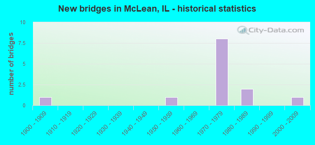
- New bridges - historical statistics
- 11900-1909
- 11950-1959
- 81970-1979
- 21980-1989
- 12000-2009


- Bridge Condition - Deck
- 22.2%Very good
- 44.4%Good
- 22.2%Satisfactory
- 11.1%Poor

- Bridge Condition - Superstructure
- 33.3%Very good
- 55.6%Good
- 11.1%Satisfactory

- Bridge Condition - Substructure
- 44.4%Very good
- 33.3%Good
- 22.2%Satisfactory

- Bridge Condition - Channel
- 57.1%Very good
- 28.6%Good
- 14.3%Fair
Find on map >> Show street view
Structure Number: 54415, Location: 2.5 E 1 MI N ATLANTA (Lat: 40.281900, Lng: -89.177233), Route carried "on" structure: County highway , Year Built: 1900, Status: Open, Structure Length: 0.73m (2.40ft), Average Daily Traffic: 50 (year 2016), Average Future Daily Traffic: 25 (year 2032), Features Intersected: KICKAPOO CK OVERFLOW, Facility Carried by Structure: TR 19
Minimum Vertical Clearance: 30+ m (98+ ft), Kilometerpoint: 0.821, Lanes on structure: 2, Owner: Town or Township Highway Agency, Approaching Roadway Width: 3.9m (12.8ft), Material/Design: Concrete, Design/Construction: Culvert, Number Of Spans In Main Unit: 3, Length of Maximum Span: 2.4m (7.9ft), Curb-To-Curb Width: 7.4m (24.3ft), Out-to-Out Width: 8.0m (26.2ft)
Condition: Channel: Fair, Culverts: Fair, Operating Rating: 23.7 metric tons, Method Used To Determine Operating Rating: Load Factor (LF) rating reported by rating factor (RF) method using MS18 loading, Inventory Rating: 14.3 metric tons, Method Used To Determine Inventory Rating: Load Factor (LF) rating reported by rating factor (RF) method using MS18 loading, Structural Evaluation: Meets minimum limits, Deck Geometry: Equal to present minimum criteria, Waterway Adequacy: Better than present minimum criteria, Approach Roadway Alignment: Equal to present desirable criteria, Designated Inspection Frequency: Every 24 months, Inspection Date: December 2020
Find on map >> Show street view
Structure Number: 570154, Location: MCLEAN (Lat: 40.311269, Lng: -89.163089), Route carried "on" structure: Interstate 55, Year Built: 1975, Status: Open, Structure Length: 6.69m (21.95ft), Average Daily Traffic: 11,150 (year 2021), Truck Traffic: 33%, Average Future Daily Traffic: 11,393 (year 2032), Design Load: HS 20+Mod, Features Intersected: US 136/FAP 315
Minimum Vertical Clearance: 30+ m (98+ ft), Kilometerpoint: 232.705, Lanes on structure: 2, Lanes under structure: 2, Base Highway Network: Yes, Owner: State Highway Agency, Approaching Roadway Width: 12.2m (40.0ft), Skew: 4 degrees, Material/Design: Steel continuous, Design/Construction: Stringer/Multi-beam, Number Of Spans In Main Unit: 2, Number Of Approach Spans: 2, Length of Maximum Span: 22.5m (73.8ft), Curb-To-Curb Width: 11.7m (38.4ft), Out-to-Out Width: 12.8m (42.0ft)
Condition: Deck: Poor, Superstructure: Good, Substructure: Satisfactory, Operating Rating: 67.4 metric tons, Method Used To Determine Operating Rating: Load Factor (LF) rating reported by rating factor (RF) method using MS18 loading, Inventory Rating: 40.5 metric tons, Method Used To Determine Inventory Rating: Load Factor (LF) rating reported by rating factor (RF) method using MS18 loading, Structural Evaluation: Equal to present minimum criteria, Deck Geometry: Equal to present minimum criteria, Underclear: Equal to present minimum criteria, Approach Roadway Alignment: Equal to present desirable criteria, Designated Inspection Frequency: Every 24 months, Inspection Date: March 2021, Deck Structure Type: Concrete Cast-file-Place, Wearing Surface/Protective System: Wearing Surface: Other
Find on map >> Show street view
Structure Number: 570155, Location: MCLEAN (Lat: 40.311383, Lng: -89.162958), Route carried "on" structure: Interstate 55, Year Built: 1975, Status: Open, Structure Length: 6.60m (21.65ft), Average Daily Traffic: 11,150 (year 2021), Truck Traffic: 33%, Average Future Daily Traffic: 11,393 (year 2032), Design Load: HS 20+Mod, Features Intersected: US 136/FAP 315
Minimum Vertical Clearance: 30+ m (98+ ft), Kilometerpoint: 232.721, Lanes on structure: 2, Lanes under structure: 2, Base Highway Network: Yes, Owner: State Highway Agency, Approaching Roadway Width: 12.2m (40.0ft), Skew: 4 degrees, Material/Design: Steel continuous, Design/Construction: Stringer/Multi-beam, Number Of Spans In Main Unit: 2, Number Of Approach Spans: 2, Length of Maximum Span: 22.5m (73.8ft), Curb-To-Curb Width: 11.7m (38.4ft), Out-to-Out Width: 12.8m (42.0ft)
Condition: Deck: Satisfactory, Superstructure: Good, Substructure: Satisfactory, Operating Rating: 67.4 metric tons, Method Used To Determine Operating Rating: Load Factor (LF) rating reported by rating factor (RF) method using MS18 loading, Inventory Rating: 40.5 metric tons, Method Used To Determine Inventory Rating: Load Factor (LF) rating reported by rating factor (RF) method using MS18 loading, Structural Evaluation: Equal to present minimum criteria, Deck Geometry: Equal to present minimum criteria, Underclear: Equal to present minimum criteria, Approach Roadway Alignment: Equal to present desirable criteria, Designated Inspection Frequency: Every 24 months, Inspection Date: August 2020, Deck Structure Type: Concrete Cast-file-Place, Wearing Surface/Protective System: Wearing Surface: Other
Find on map >> Show street view
Structure Number: 570156, Location: 1 MI S OF FUNKSGROVE (Lat: 40.353022, Lng: -89.114164), Route carried "on" structure: County highway , Year Built: 1975, Status: Open, Structure Length: 9.24m (30.31ft), Average Daily Traffic: 50 (year 2020), Average Future Daily Traffic: 66 (year 2032), Design Load: HS 15, Features Intersected: I-55, Facility Carried by Structure: TR 539
Minimum Vertical Clearance: 30+ m (98+ ft), Kilometerpoint: 6.357, Lanes on structure: 2, Lanes under structure: 4, Owner: State Highway Agency, Approaching Roadway Width: 5.8m (19.0ft), Skew: 3 degrees, Material/Design: Steel continuous, Design/Construction: Stringer/Multi-beam, Number Of Spans In Main Unit: 2, Number Of Approach Spans: 2, Length of Maximum Span: 40.8m (133.9ft), Curb-To-Curb Width: 8.1m (26.6ft), Out-to-Out Width: 9.1m (29.9ft)
Condition: Deck: Good, Superstructure: Good, Substructure: Good, Operating Rating: 45.0 metric tons, Method Used To Determine Operating Rating: Allowable Stress (AS) rating reported by rating factor (RF) method using MS18 loading, Inventory Rating: 29.5 metric tons, Method Used To Determine Inventory Rating: Allowable Stress (AS) rating reported by rating factor (RF) method using MS18 loading, Structural Evaluation: Better than present minimum criteria, Deck Geometry: Equal to present minimum criteria, Underclear: Somewhat better than minimum adequacy, Approach Roadway Alignment: Better than present minimum criteria, Designated Inspection Frequency: Every 24 months, Inspection Date: September 2020, Deck Structure Type: Concrete Cast-file-Place
Find on map >> Show street view
Structure Number: 570245, Location: 7.04 MI W OF US 51 (Lat: 40.311750, Lng: -89.122597), Route carried "on" structure: US 136, Year Built: 2006, Status: Open, Structure Length: 4.79m (15.72ft), Average Daily Traffic: 2,850 (year 2021), Truck Traffic: 30%, Average Future Daily Traffic: 2,681 (year 2032), Design Load: HS 25 or greater, Features Intersected: PRAIRIE CREEK
Minimum Vertical Clearance: 30+ m (98+ ft), Kilometerpoint: 208.340, Lanes on structure: 2, Base Highway Network: Yes, Owner: State Highway Agency, Approaching Roadway Width: 9.8m (32.2ft), Material/Design: Steel continuous, Design/Construction: Stringer/Multi-beam, Number Of Spans In Main Unit: 3, Length of Maximum Span: 20.4m (66.9ft), Curb-To-Curb Width: 11.0m (36.1ft), Out-to-Out Width: 11.9m (39.0ft)
Condition: Deck: Good, Superstructure: Very good, Substructure: Very good, Channel: Very good, Operating Rating: 64.5 metric tons, Method Used To Determine Operating Rating: Load Factor (LF) rating reported by rating factor (RF) method using MS18 loading, Inventory Rating: 38.9 metric tons, Method Used To Determine Inventory Rating: Load Factor (LF) rating reported by rating factor (RF) method using MS18 loading, Structural Evaluation: Equal to present desirable criteria, Deck Geometry: Somewhat better than minimum adequacy, Waterway Adequacy: Equal to present desirable criteria, Approach Roadway Alignment: Equal to present desirable criteria, Designated Inspection Frequency: Every 48 months, Inspection Date: September 2019, Deck Structure Type: Concrete Cast-file-Place, Wearing Surface/Protective System: Deck Protection: Epoxy Coated Reinforcing
Find on map >> Show street view
Structure Number: 574519, Location: 0.5 MI W FUNKS GROVE (Lat: 40.362917, Lng: -89.123644), Route carried "on" structure: County highway , Year Built: 1977, Status: Open, Structure Length: 2.74m (8.99ft), Average Daily Traffic: 75 (year 2020), Average Future Daily Traffic: 88 (year 2032), Design Load: HS 20, Features Intersected: TIMBER CR, Facility Carried by Structure: TR 483
Minimum Vertical Clearance: 30+ m (98+ ft), Kilometerpoint: 2.865, Lanes on structure: 2, Owner: Town or Township Highway Agency, Approaching Roadway Width: 4.3m (14.1ft), Material/Design: Concrete continuous, Design/Construction: Slab, Number Of Spans In Main Unit: 3, Length of Maximum Span: 10.4m (34.1ft), Curb-To-Curb Width: 7.3m (24.0ft), Out-to-Out Width: 7.9m (25.9ft)
Condition: Deck: Good, Superstructure: Good, Substructure: Very good, Channel: Good, Operating Rating: 44.4 metric tons, Method Used To Determine Operating Rating: Assigned rating based on Load Factor Design (LFD) reported by rating factor (RF) using MS18 loading, Inventory Rating: 32.4 metric tons, Method Used To Determine Inventory Rating: Assigned rating based on Load Factor Design (LFD) reported by rating factor (RF) using MS18 loading, Structural Evaluation: Better than present minimum criteria, Deck Geometry: Equal to present minimum criteria, Waterway Adequacy: Better than present minimum criteria, Approach Roadway Alignment: Equal to present desirable criteria, Designated Inspection Frequency: Every 24 months, Inspection Date: September 2021, Deck Structure Type: Concrete Cast-file-Place
Find on map >> Show street view
Structure Number: 57452, Location: 1.2 MI W FUNKS GROVE (Lat: 40.360642, Lng: -89.137178), Route carried "on" structure: County highway , Year Built: 1980, Status: Open, Structure Length: 2.90m (9.51ft), Average Daily Traffic: 75 (year 2020), Average Future Daily Traffic: 88 (year 2032), Design Load: HS 20, Features Intersected: TIMBER CREEK, Facility Carried by Structure: TR 483
Minimum Vertical Clearance: 30+ m (98+ ft), Kilometerpoint: 1.271, Lanes on structure: 2, Owner: Town or Township Highway Agency, Approaching Roadway Width: 4.9m (16.1ft), Material/Design: Concrete continuous, Design/Construction: Slab, Number Of Spans In Main Unit: 3, Length of Maximum Span: 10.8m (35.4ft), Curb-To-Curb Width: 7.5m (24.6ft), Out-to-Out Width: 7.9m (25.9ft)
Condition: Deck: Very good, Superstructure: Very good, Substructure: Very good, Channel: Very good, Operating Rating: 44.1 metric tons, Method Used To Determine Operating Rating: Assigned rating based on Load Factor Design (LFD) reported by rating factor (RF) using MS18 loading, Inventory Rating: 32.4 metric tons, Method Used To Determine Inventory Rating: Assigned rating based on Load Factor Design (LFD) reported by rating factor (RF) using MS18 loading, Structural Evaluation: Equal to present desirable criteria, Deck Geometry: Equal to present minimum criteria, Waterway Adequacy: Equal to present desirable criteria, Approach Roadway Alignment: Equal to present desirable criteria, Designated Inspection Frequency: Every 48 months, Inspection Date: September 2019, Deck Structure Type: Concrete Cast-file-Place
Find on map >> Show street view
Structure Number: 575205, Location: MOUNT HOPE SEC 23-24 (Lat: 40.348531, Lng: -89.169394), Route carried "on" structure: County highway , Year Built: 1959, Status: Open, Structure Length: 5.46m (17.91ft), Average Daily Traffic: 150 (year 2020), Truck Traffic: 5%, Average Future Daily Traffic: 168 (year 2032), Design Load: HS 15, Features Intersected: 1.5 MI N MCLEAN, Facility Carried by Structure: TR 52
Minimum Vertical Clearance: 30+ m (98+ ft), Kilometerpoint: 2.382, Lanes on structure: 2, Owner: Town or Township Highway Agency, Approaching Roadway Width: 5.5m (18.0ft), Material/Design: Concrete continuous, Design/Construction: Tee Beam, Number Of Spans In Main Unit: 3, Length of Maximum Span: 21.0m (68.9ft), Curb-To-Curb Width: 7.4m (24.3ft), Out-to-Out Width: 8.7m (28.5ft)
Condition: Deck: Good, Superstructure: Good, Substructure: Good, Channel: Good, Operating Rating: 40.2 metric tons, Method Used To Determine Operating Rating: Allowable Stress (AS) rating reported by rating factor (RF) method using MS18 loading, Inventory Rating: 24.0 metric tons, Method Used To Determine Inventory Rating: Allowable Stress (AS) rating reported by rating factor (RF) method using MS18 loading, Structural Evaluation: Equal to present minimum criteria, Deck Geometry: Somewhat better than minimum adequacy, Waterway Adequacy: Equal to present desirable criteria, Approach Roadway Alignment: Equal to present desirable criteria, Designated Inspection Frequency: Every 24 months, Inspection Date: Febuary 2022, Deck Structure Type: Concrete Cast-file-Place
Find on map >> Show street view
Structure Number: 575212, Location: 1.5 MI NNW MCLEAN (Lat: 40.337186, Lng: -89.194603), Route carried "on" structure: County highway , Year Built: 1975, Status: Open, Structure Length: 5.00m (16.40ft), Average Daily Traffic: 425 (year 2020), Truck Traffic: 4%, Average Future Daily Traffic: 559 (year 2032), Design Load: HS 20, Features Intersected: SUGAR CREEK, Facility Carried by Structure: FAS 479 CH 59
Minimum Vertical Clearance: 30+ m (98+ ft), Kilometerpoint: 7.741, Lanes on structure: 2, Owner: County Highway Agency, Approaching Roadway Width: 6.7m (22.0ft), Material/Design: Concrete, Design/Construction: Slab, Number Of Spans In Main Unit: 5, Length of Maximum Span: 11.6m (38.1ft), Curb-To-Curb Width: 8.5m (27.9ft), Out-to-Out Width: 9.1m (29.9ft)
Condition: Deck: Satisfactory, Superstructure: Satisfactory, Substructure: Good, Channel: Very good, Operating Rating: 54.1 metric tons, Method Used To Determine Operating Rating: Field evaluation and documented engineering judgment, Inventory Rating: 32.4 metric tons, Method Used To Determine Inventory Rating: Field evaluation and documented engineering judgment, Structural Evaluation: Equal to present minimum criteria, Deck Geometry: Somewhat better than minimum adequacy, Waterway Adequacy: Equal to present desirable criteria, Approach Roadway Alignment: Equal to present desirable criteria, Designated Inspection Frequency: Every 24 months, Inspection Date: March 2020, Deck Structure Type: Concrete Cast-file-Place
Find on map >> Show street view
Structure Number: 575215, Location: 3.5 MI N MCLEAN (Lat: 40.370069, Lng: -89.159864), Route carried "on" structure: County highway , Year Built: 1987, Status: Open, Structure Length: 5.26m (17.26ft), Average Daily Traffic: 175 (year 2020), Truck Traffic: 5%, Average Future Daily Traffic: 168 (year 2032), Design Load: HS 20, Features Intersected: SUGAR CREEK, Facility Carried by Structure: CH 36
Minimum Vertical Clearance: 30.18m (99.02ft), Kilometerpoint: 4.007, Lanes on structure: 2, Owner: County Highway Agency, Approaching Roadway Width: 9.1m (29.9ft), Material/Design: Steel continuous, Design/Construction: Stringer/Multi-beam, Number Of Spans In Main Unit: 3, Length of Maximum Span: 19.9m (65.3ft), Curb-To-Curb Width: 8.5m (27.9ft), Out-to-Out Width: 9.1m (29.9ft)
Condition: Deck: Very good, Superstructure: Very good, Substructure: Very good, Channel: Very good, Operating Rating: 44.4 metric tons, Method Used To Determine Operating Rating: Assigned rating based on Load Factor Design (LFD) reported by rating factor (RF) using MS18 loading, Inventory Rating: 32.4 metric tons, Method Used To Determine Inventory Rating: Assigned rating based on Load Factor Design (LFD) reported by rating factor (RF) using MS18 loading, Structural Evaluation: Equal to present desirable criteria, Deck Geometry: Equal to present minimum criteria, Waterway Adequacy: Better than present minimum criteria, Approach Roadway Alignment: Equal to present desirable criteria, Designated Inspection Frequency: Every 48 months, Inspection Date: March 2020, Deck Structure Type: Concrete Cast-file-Place, Wearing Surface/Protective System: Deck Protection: Epoxy Coated Reinforcing
Find on map >> Show street view
Structure Number: 570154, Location: MCLEAN (Lat: 40.311606, Lng: -89.163244), Route carried "under" structure: US 136, Year Built: 1975, Structure Length: 0. m, Average Daily Traffic: 4,900 (year 2021), Truck Traffic: 30%, Features Intersected: US 136/FAP 315, Facility Carried by Structure: I-55 SB
Minimum Vertical Clearance: 5.16m (16.93ft), Kilometerpoint: 204.896, Lanes on structure: 2, Lanes under structure: 2, Material/Design: Steel continuous, Design/Construction: Stringer/Multi-beam, Length of Maximum Span: 22.5m (73.8ft)
Find on map >> Show street view
Structure Number: 570155, Location: MCLEAN (Lat: 40.311606, Lng: -89.162694), Route carried "under" structure: US 136, Year Built: 1975, Structure Length: 0. m, Average Daily Traffic: 2,250 (year 2021), Truck Traffic: 27%, Features Intersected: US 136/FAP 315, Facility Carried by Structure: I-55 NB
Minimum Vertical Clearance: 5.05m (16.57ft), Kilometerpoint: 204.944, Lanes on structure: 2, Lanes under structure: 2, Material/Design: Steel continuous, Design/Construction: Stringer/Multi-beam, Length of Maximum Span: 22.5m (73.8ft)
Find on map >> Show street view
Structure Number: 570156, Location: 1 MI S OF FUNKSGROVE (Lat: 40.353350, Lng: -89.114169), Route carried "under" structure: Interstate 55, Year Built: 1975, Structure Length: 0. m, Average Daily Traffic: 23,000 (year 2021), Truck Traffic: 32%, Features Intersected: I-55, Facility Carried by Structure: TR 539
Minimum Vertical Clearance: 5.41m (17.75ft), Kilometerpoint: 239.126, Lanes on structure: 2, Lanes under structure: 4, Material/Design: Steel continuous, Design/Construction: Stringer/Multi-beam, Length of Maximum Span: 40.8m (133.9ft)