Bridge Statistics for McIntosh, Florida (FL)
Condition, Traffic, Stress, Structural Evaluation, Project Costs
- National Bridge Inventory (NBI) Statistics
- 10Number of bridges
- 89ft / 27.4mTotal length
- 198,300Total average daily traffic
- 42,092Total average daily truck traffic
- National Bridge Inventory (NBI) Registered Bridges for McIntosh
- No street view available for this location
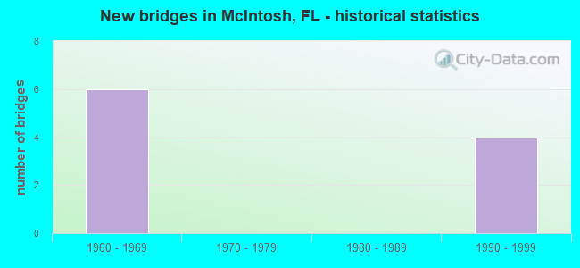
- New bridges - historical statistics
- 61960-1969
- 41990-1999


Find on map >> Show street view
Structure Number: 360034, Location: CR-320 over I-75 (Lat: 29.445533, Lng: -82.266869), Route carried "on" structure: County highway 320, Year Built: 1964, Status: Open, Structure Length: 9.23m (30.28ft), Average Daily Traffic: 400 (year 2018), Truck Traffic: 8%, Average Future Daily Traffic: 694 (year 2040), Design Load: H 20, Features Intersected: I-75
Minimum Vertical Clearance: 30+ m (98+ ft), Kilometerpoint: 14.766, Lanes on structure: 2, Lanes under structure: 6, Owner: State Highway Agency, Approaching Roadway Width: 7.4m (24.3ft), Skew: 2 degrees, Material/Design: Prestressed concrete, Design/Construction: Stringer/Multi-beam, Number Of Spans In Main Unit: 4, Length of Maximum Span: 23.4m (76.8ft), Curb or Sidewalk Widths: Left: 0.6m (2.0ft), Right: 0.6m (2.0ft), Curb-To-Curb Width: 8.5m (27.9ft), Out-to-Out Width: 10.4m (34.1ft)
Condition: Deck: Good, Superstructure: Good, Substructure: Good, Operating Rating: 64.3 metric tons, Method Used To Determine Operating Rating: Load Factor (LF), Inventory Rating: 38.6 metric tons, Method Used To Determine Inventory Rating: Load Factor (LF), Structural Evaluation: Better than present minimum criteria, Deck Geometry: Equal to present minimum criteria, Underclear: Somewhat better than minimum adequacy, Approach Roadway Alignment: Equal to present desirable criteria, Designated Inspection Frequency: Every 24 months, Inspection Date: May 2021, Deck Structure Type: Concrete Cast-file-Place
Find on map >> Show street view
Structure Number: 360037, Location: I-75 SB over CR-318 (Lat: 29.406869, Lng: -82.247733), Route carried "on" structure: Interstate 75, Year Built: 1964, Year Reconstructed: 1997, Status: Open, Structure Length: 3.80m (12.47ft), Average Daily Traffic: 30,750 (year 2020), Truck Traffic: 24%, Average Future Daily Traffic: 53,351 (year 2042), Design Load: HS 20+Mod, Features Intersected: CR-318
Minimum Vertical Clearance: 30+ m (98+ ft), Kilometerpoint: 51.996, Lanes on structure: 3, Lanes under structure: 2, Base Highway Network: Yes, Owner: State Highway Agency, Approaching Roadway Width: 16.8m (55.1ft), Material/Design: Prestressed concrete, Design/Construction: Stringer/Multi-beam, Number Of Spans In Main Unit: 3, Length of Maximum Span: 14.6m (47.9ft), Curb-To-Curb Width: 17.0m (55.8ft), Out-to-Out Width: 18.0m (59.1ft)
Condition: Deck: Good, Superstructure: Good, Substructure: Good, Operating Rating: 58.7 metric tons, Method Used To Determine Operating Rating: Load Factor (LF), Inventory Rating: 35.7 metric tons, Method Used To Determine Inventory Rating: Load Factor (LF), Structural Evaluation: Better than present minimum criteria, Deck Geometry: Equal to present minimum criteria, Underclear: Equal to present minimum criteria, Approach Roadway Alignment: Equal to present desirable criteria, Designated Inspection Frequency: Every 24 months, Inspection Date: May 2021, Deck Structure Type: Concrete Cast-file-Place
Find on map >> Show street view
Structure Number: 360038, Location: I-75 NB over CR-318 (Lat: 29.406972, Lng: -82.247514), Route carried "on" structure: Interstate 75, Year Built: 1964, Year Reconstructed: 1997, Status: Open, Structure Length: 3.80m (12.47ft), Average Daily Traffic: 32,000 (year 2018), Truck Traffic: 21%, Average Future Daily Traffic: 55,520 (year 2040), Design Load: HS 20+Mod, Features Intersected: CR-318
Minimum Vertical Clearance: 30+ m (98+ ft), Kilometerpoint: 51.996, Lanes on structure: 3, Lanes under structure: 2, Base Highway Network: Yes, Owner: State Highway Agency, Approaching Roadway Width: 16.8m (55.1ft), Material/Design: Prestressed concrete, Design/Construction: Stringer/Multi-beam, Number Of Spans In Main Unit: 3, Length of Maximum Span: 14.6m (47.9ft), Curb-To-Curb Width: 17.0m (55.8ft), Out-to-Out Width: 18.0m (59.1ft)
Condition: Deck: Good, Superstructure: Good, Substructure: Good, Operating Rating: 64.0 metric tons, Method Used To Determine Operating Rating: Load Factor (LF), Inventory Rating: 39.2 metric tons, Method Used To Determine Inventory Rating: Load Factor (LF), Structural Evaluation: Better than present minimum criteria, Deck Geometry: Equal to present minimum criteria, Underclear: Equal to present minimum criteria, Approach Roadway Alignment: Equal to present desirable criteria, Designated Inspection Frequency: Every 24 months, Inspection Date: May 2021, Deck Structure Type: Concrete Cast-file-Place
Find on map >> Show street view
Structure Number: 360065, Location: I-75 SB over NW 193rd St (Lat: 29.429000, Lng: -82.262675), Route carried "on" structure: Interstate 75, Year Built: 1997, Status: Open, Structure Length: 5.30m (17.39ft), Average Daily Traffic: 32,250 (year 2018), Truck Traffic: 21%, Average Future Daily Traffic: 55,954 (year 2040), Design Load: HS 20+Mod, Features Intersected: NW 193rd St
Minimum Vertical Clearance: 30+ m (98+ ft), Kilometerpoint: 54.832, Lanes on structure: 3, Lanes under structure: 2, Base Highway Network: Yes, Owner: State Highway Agency, Approaching Roadway Width: 19.8m (65.0ft), Skew: 1 degrees, Material/Design: Prestressed concrete, Design/Construction: Stringer/Multi-beam, Number Of Spans In Main Unit: 3, Length of Maximum Span: 17.7m (58.1ft), Curb-To-Curb Width: 19.8m (65.0ft), Out-to-Out Width: 20.5m (67.3ft)
Condition: Deck: Good, Superstructure: Good, Substructure: Good, Operating Rating: 59.0 metric tons, Method Used To Determine Operating Rating: Load Factor (LF), Inventory Rating: 35.4 metric tons, Method Used To Determine Inventory Rating: Load Factor (LF), Structural Evaluation: Better than present minimum criteria, Deck Geometry: Superior to present desirable criteria, Underclear: Superior to present desirable criteria, Approach Roadway Alignment: Equal to present desirable criteria, Designated Inspection Frequency: Every 24 months, Inspection Date: May 2021, Deck Structure Type: Concrete Cast-file-Place
Find on map >> Show street view
Structure Number: 360066, Location: I-75 NB over NW 193rd St (Lat: 29.429006, Lng: -82.262442), Route carried "on" structure: Interstate 75, Year Built: 1997, Status: Open, Structure Length: 5.30m (17.39ft), Average Daily Traffic: 28,250 (year 2020), Truck Traffic: 24%, Average Future Daily Traffic: 49,014 (year 2042), Design Load: HS 20+Mod, Features Intersected: NW 193rd St
Minimum Vertical Clearance: 30+ m (98+ ft), Kilometerpoint: 54.829, Lanes on structure: 3, Lanes under structure: 2, Base Highway Network: Yes, Owner: State Highway Agency, Approaching Roadway Width: 19.8m (65.0ft), Skew: 1 degrees, Material/Design: Prestressed concrete, Design/Construction: Stringer/Multi-beam, Number Of Spans In Main Unit: 3, Length of Maximum Span: 17.7m (58.1ft), Curb-To-Curb Width: 19.8m (65.0ft), Out-to-Out Width: 20.5m (67.3ft)
Condition: Deck: Good, Superstructure: Good, Substructure: Good, Operating Rating: 59.5 metric tons, Method Used To Determine Operating Rating: Load Factor (LF), Inventory Rating: 35.7 metric tons, Method Used To Determine Inventory Rating: Load Factor (LF), Structural Evaluation: Better than present minimum criteria, Deck Geometry: Superior to present desirable criteria, Underclear: Superior to present desirable criteria, Approach Roadway Alignment: Equal to present desirable criteria, Designated Inspection Frequency: Every 24 months, Inspection Date: May 2021, Deck Structure Type: Concrete Cast-file-Place
Find on map >> Show street view
Structure Number: 360034, Location: CR-320 over I-75 (Lat: 29.445533, Lng: -82.266869), Route carried "under" structure: Interstate 75, Year Built: 1964, Structure Length: 0. m, Average Daily Traffic: 64,500 (year 2018), Truck Traffic: 21%, Features Intersected: I-75, Facility Carried by Structure: CR-320
Minimum Vertical Clearance: 5.09m (16.70ft), Kilometerpoint: 56.786, Lanes on structure: 2, Lanes under structure: 6, Material/Design: Prestressed concrete, Design/Construction: Stringer/Multi-beam, Length of Maximum Span: 23.4m (76.8ft)
Find on map >> Show street view
Structure Number: 360037, Location: I-75 SB over CR-318 (Lat: 29.406869, Lng: -82.247733), Route carried "under" structure: County highway 318, Year Built: 1964, Structure Length: 0. m, Average Daily Traffic: 4,700 (year 2020), Truck Traffic: 9%, Features Intersected: CR-318, Facility Carried by Structure: I-75
Minimum Vertical Clearance: 4.72m (15.49ft), Kilometerpoint: 16.106, Lanes on structure: 3, Lanes under structure: 2, Material/Design: Prestressed concrete, Design/Construction: Stringer/Multi-beam, Length of Maximum Span: 14.6m (47.9ft)
Find on map >> Show street view
Structure Number: 360038, Location: I-75 NB over CR-318 (Lat: 29.406972, Lng: -82.247514), Route carried "under" structure: County highway , Year Built: 1964, Structure Length: 0. m, Average Daily Traffic: 4,700 (year 2018), Truck Traffic: 8%, Features Intersected: CR-318, Facility Carried by Structure: I-75 NB
Minimum Vertical Clearance: 5.30m (17.39ft), Kilometerpoint: 16.129, Lanes on structure: 3, Lanes under structure: 2, Material/Design: Prestressed concrete, Design/Construction: Stringer/Multi-beam, Length of Maximum Span: 14.6m (47.9ft)
Find on map >> Show street view
Structure Number: 360065, Location: I-75 SB over NW 193rd St (Lat: 29.429000, Lng: -82.262675), Route carried "under" structure: County highway , Year Built: 1997, Structure Length: 0. m, Average Daily Traffic: 300 (year 2018), Truck Traffic: 8%, Features Intersected: NW 193rd St, Facility Carried by Structure: I-75
Minimum Vertical Clearance: 5.19m (17.03ft), Kilometerpoint: 5.060, Lanes on structure: 3, Lanes under structure: 2, Material/Design: Prestressed concrete, Design/Construction: Stringer/Multi-beam, Length of Maximum Span: 17.7m (58.1ft)
Find on map >> Show street view
Structure Number: 360066, Location: I-75 NB over NW 193rd St (Lat: 29.429006, Lng: -82.262442), Route carried "under" structure: County highway , Year Built: 1997, Structure Length: 0. m, Average Daily Traffic: 450 (year 2020), Truck Traffic: 9%, Features Intersected: NW 193rd St, Facility Carried by Structure: I-75 NB
Minimum Vertical Clearance: 6.04m (19.82ft), Kilometerpoint: 5.082, Lanes on structure: 3, Lanes under structure: 2, Material/Design: Prestressed concrete, Design/Construction: Stringer/Multi-beam, Length of Maximum Span: 17.7m (58.1ft)