Bridge Statistics for McGuffey, Ohio (OH)
Condition, Traffic, Stress, Structural Evaluation, Project Costs
- National Bridge Inventory (NBI) Statistics
- 14Number of bridges
- 82ft / 25.2mTotal length
- 5,892Total average daily traffic
- 401Total average daily truck traffic
- 8,180Total future (year 2035) average daily traffic
- National Bridge Inventory (NBI) Registered Bridges for McGuffey
- No street view available for this location
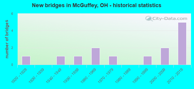
- New bridges - historical statistics
- 11920-1929
- 11940-1949
- 11950-1959
- 21960-1969
- 11970-1979
- 11990-1999
- 22000-2009
- 52010-2019

- Reconstructed bridges - Historical Statistics
- 11980-1989
- 11990-1999
- 22000-2009

- Bridge Condition - Deck
- 35.7%Excellent
- 21.4%Very good
- 28.6%Good
- 7.1%Satisfactory
- 7.1%Poor

- Bridge Condition - Superstructure
- 42.9%Excellent
- 21.4%Very good
- 21.4%Good
- 7.1%Fair
- 7.1%Poor

- Bridge Condition - Substructure
- 42.9%Excellent
- 28.6%Very good
- 14.3%Satisfactory
- 7.1%Fair
- 7.1%Poor

- Bridge Condition - Channel
- 14.3%Very good
- 50.0%Good
- 21.4%Satisfactory
- 14.3%Fair
Find on map >> Show street view
Structure Number: 3301419, Location: SR 195 (Lat: 40.689281, Lng: -83.785350), Route carried "on" structure: State highway 195, Year Built: 1967, Status: Open, Structure Length: 1.16m (3.81ft), Average Daily Traffic: 766 (year 2018), Truck Traffic: 5%, Average Future Daily Traffic: 1,063 (year 2038), Design Load: H 20, Features Intersected: COTTONWOOD DITCH #
Minimum Vertical Clearance: 30+ m (98+ ft), Kilometerpoint: 1.642, Lanes on structure: 2, Owner: State Highway Agency, Approaching Roadway Width: 9.8m (32.2ft), Material/Design: Concrete, Design/Construction: Slab, Number Of Spans In Main Unit: 1, Length of Maximum Span: 11.0m (36.1ft), Curb-To-Curb Width: 9.8m (32.2ft), Out-to-Out Width: 9.8m (32.2ft)
Condition: Deck: Very good, Superstructure: Very good, Substructure: Very good, Channel: Very good, Operating Rating: 38.9 metric tons, Method Used To Determine Operating Rating: Load Factor (LF) rating reported by rating factor (RF) method using MS18 loading, Inventory Rating: 29.2 metric tons, Method Used To Determine Inventory Rating: Load Factor (LF) rating reported by rating factor (RF) method using MS18 loading, Structural Evaluation: Better than present minimum criteria, Deck Geometry: Equal to present minimum criteria, Waterway Adequacy: Equal to present desirable criteria, Approach Roadway Alignment: Equal to present desirable criteria, Designated Inspection Frequency: Every 24 months, Inspection Date: June 2021, Deck Structure Type: Concrete Cast-file-Place, Wearing Surface/Protective System: Wearing Surface: Latex Concrete, Membrane: Built-up
Find on map >> Show street view
Structure Number: 3330002, Location: .2 MI S OF JCT OF CR 130 (Lat: 40.632881, Lng: -83.764439), Route carried "on" structure: County highway C0075, Year Built: 2014, Status: Open, Structure Length: 0.88m (2.89ft), Average Daily Traffic: 484 (year 2015), Truck Traffic: 7%, Average Future Daily Traffic: 672 (year 2035), Design Load: HL 93, Features Intersected: SPONSLER DITCH, Facility Carried by Structure: COUNTY ROAD 75
Minimum Vertical Clearance: 30+ m (98+ ft), Kilometerpoint: 12.070, Lanes on structure: 2, Owner: County Highway Agency, Approaching Roadway Width: 5.9m (19.4ft), Skew: 5 degrees, Material/Design: Concrete, Design/Construction: Box Beam or Girders - Multiple, Number Of Spans In Main Unit: 1, Length of Maximum Span: 7.3m (24.0ft), Curb-To-Curb Width: 8.2m (26.9ft), Out-to-Out Width: 8.2m (26.9ft)
Condition: Deck: Excellent, Superstructure: Excellent, Substructure: Excellent, Channel: Good, Operating Rating: 94.0 metric tons, Method Used To Determine Operating Rating: Load and Resistance Factor Rating (LRFR) rating reported by rating factor(RF) method using HL-93 loadings, Inventory Rating: 71.3 metric tons, Method Used To Determine Inventory Rating: Load and Resistance Factor Rating (LRFR) rating reported by rating factor(RF) method using HL-93 loadings, Structural Evaluation: Superior to present desirable criteria, Deck Geometry: Somewhat better than minimum adequacy, Waterway Adequacy: Better than present minimum criteria, Approach Roadway Alignment: Equal to present desirable criteria, Designated Inspection Frequency: Every 24 months, Inspection Date: May 2021, Deck Structure Type: Concrete Cast-file-Place, Wearing Surface/Protective System: Wearing Surface: Bituminous
Find on map >> Show street view
Structure Number: 3330028, Location: .2 MI E OF JCT OF CR 75 (Lat: 40.674419, Lng: -83.761900), Route carried "on" structure: County highway C0110, Year Built: 2010, Status: Open, Structure Length: 0.98m (3.22ft), Average Daily Traffic: 350 (year 2018), Truck Traffic: 7%, Average Future Daily Traffic: 486 (year 2038), Design Load: HS 20, Features Intersected: SHELDON DITCH, Facility Carried by Structure: COUNTY ROAD 110
Minimum Vertical Clearance: 30+ m (98+ ft), Kilometerpoint: 9.656, Lanes on structure: 2, Owner: County Highway Agency, Approaching Roadway Width: 5.8m (19.0ft), Material/Design: Concrete, Design/Construction: Box Beam or Girders - Multiple, Number Of Spans In Main Unit: 1, Length of Maximum Span: 8.8m (28.9ft), Curb-To-Curb Width: 8.1m (26.6ft), Out-to-Out Width: 8.3m (27.2ft)
Condition: Deck: Good, Superstructure: Good, Substructure: Excellent, Channel: Good, Operating Rating: 71.3 metric tons, Method Used To Determine Operating Rating: Load and Resistance Factor Rating (LRFR) rating reported by rating factor(RF) method using HL-93 loadings, Inventory Rating: 55.1 metric tons, Method Used To Determine Inventory Rating: Load and Resistance Factor Rating (LRFR) rating reported by rating factor(RF) method using HL-93 loadings, Structural Evaluation: Better than present minimum criteria, Deck Geometry: Somewhat better than minimum adequacy, Waterway Adequacy: Equal to present minimum criteria, Approach Roadway Alignment: Equal to present desirable criteria, Designated Inspection Frequency: Every 24 months, Inspection Date: May 2021, Deck Structure Type: Concrete Cast-file-Place, Wearing Surface/Protective System: Wearing Surface: Bituminous
Find on map >> Show street view
Structure Number: 3330117, Location: JCT OF CR 110 & CR 75 (Lat: 40.674539, Lng: -83.771650), Route carried "on" structure: County highway C0110, Year Built: 2002, Status: Open, Structure Length: 1.28m (4.20ft), Average Daily Traffic: 744 (year 2018), Truck Traffic: 8%, Average Future Daily Traffic: 1,033 (year 2038), Design Load: HS 20, Features Intersected: FLAT BRANCH, Facility Carried by Structure: COUNTY ROAD 110
Minimum Vertical Clearance: 30+ m (98+ ft), Kilometerpoint: 9.173, Lanes on structure: 2, Owner: County Highway Agency, Approaching Roadway Width: 5.8m (19.0ft), Material/Design: Steel, Design/Construction: Stringer/Multi-beam, Number Of Spans In Main Unit: 1, Length of Maximum Span: 11.9m (39.0ft), Curb-To-Curb Width: 9.8m (32.2ft), Out-to-Out Width: 9.8m (32.2ft)
Condition: Deck: Excellent, Superstructure: Excellent, Substructure: Poor, Channel: Fair, Operating Rating: 42.1 metric tons, Method Used To Determine Operating Rating: Allowable Stress (AS) rating reported by rating factor (RF) method using MS18 loading, Inventory Rating: 32.4 metric tons, Method Used To Determine Inventory Rating: Allowable Stress (AS) rating reported by rating factor (RF) method using MS18 loading, Structural Evaluation: Meets minimum limits, Deck Geometry: Equal to present minimum criteria, Waterway Adequacy: Better than present minimum criteria, Approach Roadway Alignment: Equal to present desirable criteria, Designated Inspection Frequency: Every 12 months, Inspection Date: May 2021, Deck Structure Type: Corrugated Steel, Wearing Surface/Protective System: Wearing Surface: Bituminous
Find on map >> Show street view
Structure Number: 3330222, Location: .2 MI W OF JCT OF CR 75 (Lat: 40.674669, Lng: -83.776419), Route carried "on" structure: County highway C0110, Year Built: 2011, Status: Open, Structure Length: 4.75m (15.58ft), Average Daily Traffic: 744 (year 2015), Truck Traffic: 8%, Average Future Daily Traffic: 1,033 (year 2035), Design Load: HS 20, Features Intersected: SCIOTO RIVER, Facility Carried by Structure: COUNTY ROAD 110
Minimum Vertical Clearance: 30+ m (98+ ft), Kilometerpoint: 8.851, Lanes on structure: 2, Owner: County Highway Agency, Approaching Roadway Width: 5.8m (19.0ft), Skew: 4 degrees, Material/Design: Steel, Design/Construction: Truss - Thru, Number Of Spans In Main Unit: 1, Length of Maximum Span: 45.7m (149.9ft), Curb-To-Curb Width: 7.9m (25.9ft), Out-to-Out Width: 8.3m (27.2ft)
Condition: Deck: Excellent, Superstructure: Excellent, Substructure: Excellent, Channel: Satisfactory, Operating Rating: 58.3 metric tons, Method Used To Determine Operating Rating: Load Factor (LF) rating reported by rating factor (RF) method using MS18 loading, Inventory Rating: 35.6 metric tons, Method Used To Determine Inventory Rating: Load Factor (LF) rating reported by rating factor (RF) method using MS18 loading, Structural Evaluation: Superior to present desirable criteria, Deck Geometry: Somewhat better than minimum adequacy, Waterway Adequacy: Equal to present minimum criteria, Approach Roadway Alignment: Somewhat better than minimum adequacy, Designated Inspection Frequency: Every 12 months, Critical Feature Inspection Frequency: Every 24 months, Inspection Date: May 2021, Critical Feature Inspection Date: May 2021, Deck Structure Type: Corrugated Steel, Wearing Surface/Protective System: Wearing Surface: Bituminous
Find on map >> Show street view
Structure Number: 3331814, Location: .3 MI.E.OF JCT.OF C.R. 75 (Lat: 40.640011, Lng: -83.758950), Route carried "on" structure: County highway C0130, Year Built: 1965, Year Reconstructed: 2000, Status: Open, Structure Length: 1.10m (3.61ft), Average Daily Traffic: 204 (year 2018), Truck Traffic: 5%, Average Future Daily Traffic: 283 (year 2038), Design Load: HS 20, Features Intersected: SPONSLER DITCH, Facility Carried by Structure: COUNTY ROAD 130
Minimum Vertical Clearance: 30+ m (98+ ft), Kilometerpoint: 10.058, Lanes on structure: 2, Owner: County Highway Agency, Approaching Roadway Width: 5.5m (18.0ft), Skew: 5 degrees, Material/Design: Steel, Design/Construction: Stringer/Multi-beam, Number Of Spans In Main Unit: 1, Length of Maximum Span: 8.2m (26.9ft), Curb-To-Curb Width: 7.3m (24.0ft), Out-to-Out Width: 7.3m (24.0ft)
Condition: Deck: Very good, Superstructure: Excellent, Substructure: Very good, Channel: Good, Operating Rating: 42.1 metric tons, Method Used To Determine Operating Rating: Allowable Stress (AS) rating reported by rating factor (RF) method using MS18 loading, Inventory Rating: 32.4 metric tons, Method Used To Determine Inventory Rating: Allowable Stress (AS) rating reported by rating factor (RF) method using MS18 loading, Structural Evaluation: Equal to present desirable criteria, Deck Geometry: Somewhat better than minimum adequacy, Waterway Adequacy: Better than present minimum criteria, Approach Roadway Alignment: Equal to present desirable criteria, Designated Inspection Frequency: Every 24 months, Inspection Date: May 2021, Deck Structure Type: Corrugated Steel, Wearing Surface/Protective System: Wearing Surface: Bituminous
Find on map >> Show street view
Structure Number: 3331946, Location: .8 MI N OF JCT OF CR 130 (Lat: 40.651669, Lng: -83.767639), Route carried "on" structure: County highway C0075, Year Built: 2012, Status: Open, Structure Length: 1.52m (4.99ft), Average Daily Traffic: 484 (year 2018), Truck Traffic: 7%, Average Future Daily Traffic: 672 (year 2038), Design Load: HL 93, Features Intersected: SPONSLER DITCH, Facility Carried by Structure: COUNTY ROAD 75
Minimum Vertical Clearance: 30+ m (98+ ft), Kilometerpoint: 14.484, Lanes on structure: 2, Owner: County Highway Agency, Approaching Roadway Width: 6.1m (20.0ft), Skew: 2 degrees, Material/Design: Prestressed concrete, Design/Construction: Box Beam or Girders - Multiple, Number Of Spans In Main Unit: 1, Length of Maximum Span: 14.3m (46.9ft), Curb-To-Curb Width: 8.3m (27.2ft), Out-to-Out Width: 8.3m (27.2ft)
Condition: Deck: Excellent, Superstructure: Excellent, Substructure: Excellent, Channel: Very good, Operating Rating: 58.3 metric tons, Method Used To Determine Operating Rating: Load and Resistance Factor Rating (LRFR) rating reported by rating factor(RF) method using HL-93 loadings, Inventory Rating: 45.4 metric tons, Method Used To Determine Inventory Rating: Load and Resistance Factor Rating (LRFR) rating reported by rating factor(RF) method using HL-93 loadings, Structural Evaluation: Superior to present desirable criteria, Deck Geometry: Somewhat better than minimum adequacy, Waterway Adequacy: Better than present minimum criteria, Approach Roadway Alignment: Equal to present desirable criteria, Designated Inspection Frequency: Every 24 months, Inspection Date: May 2021, Deck Structure Type: Concrete Cast-file-Place, Wearing Surface/Protective System: Wearing Surface: Bituminous
Find on map >> Show street view
Structure Number: 3332152, Location: JCT OF SR 195 & CR 65 (Lat: 40.663689, Lng: -83.792389), Route carried "on" structure: County highway C0065, Year Built: 2006, Status: Open, Structure Length: 3.26m (10.70ft), Average Daily Traffic: 654 (year 2015), Truck Traffic: 7%, Average Future Daily Traffic: 908 (year 2035), Design Load: HS 20+Mod, Features Intersected: SCIOTO RIVER, Facility Carried by Structure: COUNTY ROAD 65
Minimum Vertical Clearance: 30+ m (98+ ft), Kilometerpoint: 15.289, Lanes on structure: 2, Owner: County Highway Agency, Approaching Roadway Width: 5.8m (19.0ft), Material/Design: Steel, Design/Construction: Truss - Thru, Number Of Spans In Main Unit: 1, Length of Maximum Span: 31.4m (103.0ft), Curb-To-Curb Width: 9.8m (32.2ft), Out-to-Out Width: 10.1m (33.1ft)
Condition: Deck: Good, Superstructure: Excellent, Substructure: Excellent, Channel: Satisfactory, Operating Rating: 48.6 metric tons, Method Used To Determine Operating Rating: Allowable Stress (AS) rating reported by rating factor (RF) method using MS18 loading, Inventory Rating: 25.9 metric tons, Method Used To Determine Inventory Rating: Allowable Stress (AS) rating reported by rating factor (RF) method using MS18 loading, Structural Evaluation: Equal to present minimum criteria, Deck Geometry: Equal to present minimum criteria, Waterway Adequacy: Better than present minimum criteria, Approach Roadway Alignment: Somewhat better than minimum adequacy, Designated Inspection Frequency: Every 12 months, Critical Feature Inspection Frequency: Every 24 months, Inspection Date: May 2021, Critical Feature Inspection Date: May 2021, Deck Structure Type: Corrugated Steel, Wearing Surface/Protective System: Wearing Surface: Bituminous
Find on map >> Show street view
Structure Number: 3333086, Location: .2 MI E OF JCT. OF C.R.95 (Lat: 40.675711, Lng: -83.726519), Route carried "on" structure: County highway C0106, Year Built: 1953, Year Reconstructed: 1992, Status: Open, Structure Length: 0.98m (3.22ft), Average Daily Traffic: 291 (year 2015), Truck Traffic: 8%, Average Future Daily Traffic: 404 (year 2035), Design Load: HS 20, Features Intersected: MCCOY RUN, Facility Carried by Structure: COUNTY ROAD 106
Minimum Vertical Clearance: 30+ m (98+ ft), Kilometerpoint: 12.875, Lanes on structure: 2, Owner: County Highway Agency, Approaching Roadway Width: 5.8m (19.0ft), Skew: 3 degrees, Material/Design: Steel, Design/Construction: Stringer/Multi-beam, Number Of Spans In Main Unit: 1, Length of Maximum Span: 8.8m (28.9ft), Curb-To-Curb Width: 6.7m (22.0ft), Out-to-Out Width: 6.7m (22.0ft)
Condition: Deck: Good, Superstructure: Fair, Substructure: Satisfactory, Channel: Good, Operating Rating: 61.6 metric tons, Method Used To Determine Operating Rating: Load Factor (LF) rating reported by rating factor (RF) method using MS18 loading, Inventory Rating: 35.6 metric tons, Method Used To Determine Inventory Rating: Load Factor (LF) rating reported by rating factor (RF) method using MS18 loading, Structural Evaluation: Somewhat better than minimum adequacy, Deck Geometry: Meets minimum limits, Waterway Adequacy: Equal to present desirable criteria, Approach Roadway Alignment: Equal to present desirable criteria, Designated Inspection Frequency: Every 12 months, Inspection Date: September 2021, Deck Structure Type: Corrugated Steel, Wearing Surface/Protective System: Wearing Surface: Bituminous
Find on map >> Show street view
Structure Number: 3334406, Location: .4 MI S OF JCT OF TWP 100 (Lat: 40.684289, Lng: -83.730411), Route carried "on" structure: County highway C0095, Year Built: 1922, Year Reconstructed: 2004, Status: Posted for load, Structure Length: 4.02m (13.19ft), Average Daily Traffic: 190 (year 2015), Truck Traffic: 7%, Average Future Daily Traffic: 264 (year 2035), Design Load: HS 20+Mod, Features Intersected: SCIOTO RIVER, Facility Carried by Structure: COUNTY ROAD 95
Minimum Vertical Clearance: 30+ m (98+ ft), Kilometerpoint: 17.703, Lanes on structure: 2, Owner: County Highway Agency, Approaching Roadway Width: 5.8m (19.0ft), Material/Design: Steel, Design/Construction: Truss - Thru, Number Of Spans In Main Unit: 1, Length of Maximum Span: 39.0m (128.0ft), Curb-To-Curb Width: 7.3m (24.0ft), Out-to-Out Width: 7.4m (24.3ft)
Condition: Deck: Excellent, Superstructure: Good, Substructure: Satisfactory, Channel: Good, Operating Rating: 38.9 metric tons, Method Used To Determine Operating Rating: Allowable Stress (AS) rating reported by rating factor (RF) method using MS18 loading, Inventory Rating: 22.7 metric tons, Method Used To Determine Inventory Rating: Allowable Stress (AS) rating reported by rating factor (RF) method using MS18 loading, Structural Evaluation: Equal to present minimum criteria, Deck Geometry: Somewhat better than minimum adequacy, Waterway Adequacy: Equal to present desirable criteria, Approach Roadway Alignment: Equal to present minimum criteria, Bridge Posting: Required (Relationship of Operating Rating to Maximum Legal Load: 0.1 - 9.9% below), Designated Inspection Frequency: Every 12 months, Critical Feature Inspection Frequency: Every 24 months, Inspection Date: September 2021, Critical Feature Inspection Date: September 2021, Deck Structure Type: Corrugated Steel, Wearing Surface/Protective System: Wearing Surface: Bituminous
Find on map >> Show street view
Structure Number: 3337227, Location: .3 MI N OF JCT OF SR 701 (Lat: 40.736981, Lng: -83.747989), Route carried "on" structure: County highway 85, Year Built: 1940, Status: Open, Structure Length: 0.98m (3.22ft), Average Daily Traffic: 324 (year 2015), Truck Traffic: 7%, Average Future Daily Traffic: 450 (year 2035), Design Load: H 15, Features Intersected: SEARSON DITCH
Minimum Vertical Clearance: 30+ m (98+ ft), Kilometerpoint: 23.657, Lanes on structure: 2, Owner: County Highway Agency, Approaching Roadway Width: 3.7m (12.1ft), Skew: 5 degrees, Material/Design: Concrete, Design/Construction: Slab, Number Of Spans In Main Unit: 1, Length of Maximum Span: 8.2m (26.9ft), Curb-To-Curb Width: 6.9m (22.6ft), Out-to-Out Width: 7.1m (23.3ft)
Condition: Deck: Poor, Superstructure: Poor, Substructure: Fair, Channel: Fair, Operating Rating: 34.6 metric tons, Method Used To Determine Operating Rating: Field evaluation and documented engineering judgment, Inventory Rating: 25.5 metric tons, Method Used To Determine Inventory Rating: Field evaluation and documented engineering judgment, Structural Evaluation: Meets minimum limits, Deck Geometry: Meets minimum limits, Waterway Adequacy: Equal to present desirable criteria, Approach Roadway Alignment: Equal to present desirable criteria, Designated Inspection Frequency: Every 12 months, Inspection Date: June 2021, Deck Structure Type: Concrete Cast-file-Place, Wearing Surface/Protective System: Wearing Surface: Bituminous
Find on map >> Show street view
Structure Number: 3337456, Location: .4 MI N OF JCT OF SR 701 (Lat: 40.738181, Lng: -83.765789), Route carried "on" structure: County highway C0075, Year Built: 2010, Status: Open, Structure Length: 0.98m (3.22ft), Average Daily Traffic: 129 (year 2015), Truck Traffic: 8%, Average Future Daily Traffic: 179 (year 2035), Design Load: HS 20, Features Intersected: POWELL DITCH, Facility Carried by Structure: COUNTY ROAD 75
Minimum Vertical Clearance: 30+ m (98+ ft), Kilometerpoint: 25.428, Lanes on structure: 2, Owner: County Highway Agency, Approaching Roadway Width: 5.2m (17.1ft), Material/Design: Concrete, Design/Construction: Box Beam or Girders - Multiple, Number Of Spans In Main Unit: 1, Length of Maximum Span: 8.8m (28.9ft), Curb-To-Curb Width: 7.2m (23.6ft), Out-to-Out Width: 7.4m (24.3ft)
Condition: Deck: Very good, Superstructure: Very good, Substructure: Excellent, Channel: Good, Operating Rating: 94.0 metric tons, Method Used To Determine Operating Rating: Load Factor (LF) rating reported by rating factor (RF) method using MS18 loading, Inventory Rating: 58.3 metric tons, Method Used To Determine Inventory Rating: Load Factor (LF) rating reported by rating factor (RF) method using MS18 loading, Structural Evaluation: Equal to present desirable criteria, Deck Geometry: Meets minimum limits, Waterway Adequacy: Equal to present desirable criteria, Approach Roadway Alignment: Equal to present desirable criteria, Designated Inspection Frequency: Every 24 months, Inspection Date: June 2021, Deck Structure Type: Concrete Cast-file-Place, Wearing Surface/Protective System: Wearing Surface: Bituminous
Find on map >> Show street view
Structure Number: 3338444, Location: .1 MI N OF JCT OF S.R.701 (Lat: 40.734050, Lng: -83.748000), Route carried "on" structure: County highway 85, Year Built: 1994, Status: Open, Structure Length: 0.79m (2.59ft), Average Daily Traffic: 324 (year 2015), Truck Traffic: 7%, Average Future Daily Traffic: 450 (year 2035), Design Load: HS 20, Features Intersected: DITCH NO. 2 LATERAL
Minimum Vertical Clearance: 30+ m (98+ ft), Kilometerpoint: 23.175, Lanes on structure: 2, Owner: County Highway Agency, Approaching Roadway Width: 3.4m (11.2ft), Skew: 3 degrees, Material/Design: Concrete, Design/Construction: Box Beam or Girders - Multiple, Number Of Spans In Main Unit: 1, Length of Maximum Span: 7.0m (23.0ft), Curb-To-Curb Width: 7.2m (23.6ft), Out-to-Out Width: 7.3m (24.0ft)
Condition: Deck: Good, Superstructure: Good, Substructure: Very good, Channel: Good, Operating Rating: 42.1 metric tons, Method Used To Determine Operating Rating: Load Factor (LF) rating reported by rating factor (RF) method using MS18 loading, Inventory Rating: 32.4 metric tons, Method Used To Determine Inventory Rating: Load Factor (LF) rating reported by rating factor (RF) method using MS18 loading, Structural Evaluation: Better than present minimum criteria, Deck Geometry: Meets minimum limits, Waterway Adequacy: Better than present minimum criteria, Approach Roadway Alignment: Equal to present desirable criteria, Designated Inspection Frequency: Every 24 months, Inspection Date: June 2021, Deck Structure Type: Concrete Cast-file-Place, Wearing Surface/Protective System: Wearing Surface: Bituminous
Find on map >> Show street view
Structure Number: 3346935, Location: AT JCT OF SR 195 (Lat: 40.637661, Lng: -83.806881), Route carried "on" structure: County highway C0130, Year Built: 1979, Year Reconstructed: 2000, Status: Posted for load, Structure Length: 2.56m (8.40ft), Average Daily Traffic: 204 (year 2015), Truck Traffic: 5%, Average Future Daily Traffic: 283 (year 2035), Design Load: H 20, Features Intersected: SCIOTO RIVER, Facility Carried by Structure: COUNTY ROAD 130
Minimum Vertical Clearance: 30+ m (98+ ft), Kilometerpoint: 6.437, Lanes on structure: 2, Owner: County Highway Agency, Approaching Roadway Width: 5.5m (18.0ft), Material/Design: Steel, Design/Construction: Truss - Thru, Number Of Spans In Main Unit: 1, Length of Maximum Span: 24.4m (80.1ft), Curb-To-Curb Width: 7.8m (25.6ft), Out-to-Out Width: 8.0m (26.2ft)
Condition: Deck: Satisfactory, Superstructure: Very good, Substructure: Very good, Channel: Satisfactory, Operating Rating: 32.4 metric tons, Method Used To Determine Operating Rating: Allowable Stress (AS) rating reported by rating factor (RF) method using MS18 loading, Inventory Rating: 19.4 metric tons, Method Used To Determine Inventory Rating: Allowable Stress (AS) rating reported by rating factor (RF) method using MS18 loading, Structural Evaluation: Somewhat better than minimum adequacy, Deck Geometry: Somewhat better than minimum adequacy, Waterway Adequacy: Better than present minimum criteria, Approach Roadway Alignment: High priority of replacement, Bridge Posting: Required (Relationship of Operating Rating to Maximum Legal Load: 20.0 - 29.9% below), Designated Inspection Frequency: Every 12 months, Critical Feature Inspection Frequency: Every 24 months, Inspection Date: June 2021, Critical Feature Inspection Date: June 2021, Deck Structure Type: Corrugated Steel, Wearing Surface/Protective System: Wearing Surface: Bituminous