Bridge Statistics for McElhattan, Pennsylvania (PA)
Condition, Traffic, Stress, Structural Evaluation, Project Costs
- National Bridge Inventory (NBI) Statistics
- 26Number of bridges
- 384ft / 117mTotal length
- $16,110,000Total costs
- 88,094Total average daily traffic
- 11,285Total average daily truck traffic
- National Bridge Inventory (NBI) Registered Bridges for McElhattan
- No street view available for this location
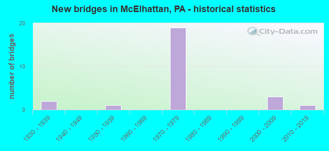
- New bridges - historical statistics
- 21930-1939
- 11950-1959
- 191970-1979
- 32000-2009
- 12010-2019

- Reconstructed bridges - Historical Statistics
- 11960-1969
- 01970-1979
- 01980-1989
- 01990-1999
- 12000-2009
- 22010-2019


- Bridge Condition - Deck
- 38.5%Very good
- 46.2%Good
- 15.4%Fair

- Bridge Condition - Superstructure
- 23.1%Very good
- 23.1%Good
- 46.2%Satisfactory
- 7.7%Fair

- Bridge Condition - Substructure
- 15.4%Very good
- 38.5%Good
- 38.5%Satisfactory
- 7.7%Fair

- Bridge Condition - Channel
- 7.1%Very good
- 35.7%Good
- 35.7%Satisfactory
- 21.4%Fair

- Bridge Condition - Culverts
- 20.0%Very good
- 20.0%Good
- 20.0%Satisfactory
- 20.0%Fair
- 20.0%Poor
Find on map >> Show street view
Structure Number: 12177, Location: MCELHATTAN (Lat: 41.167750, Lng: -77.369861), Route carried "on" structure: State highway 150, Year Built: 1938, Year Reconstructed: 1971, Status: Open, Structure Length: 0.94m (3.08ft), Average Daily Traffic: 3,962 (year 2022), Truck Traffic: 6%, Average Future Daily Traffic: 10,760 (year 2040), Design Load: H 20, Features Intersected: PLUM RUN
Minimum Vertical Clearance: 30+ m (98+ ft), Kilometerpoint: 22.701, Lanes on structure: 2, Owner: State Highway Agency, Approaching Roadway Width: 17.7m (58.1ft), Skew: 3 degrees, Material/Design: Concrete, Design/Construction: Culvert, Number Of Spans In Main Unit: 1, Length of Maximum Span: 9.4m (30.8ft)
Condition: Channel: Fair, Culverts: Fair, Operating Rating: 41.7 metric tons, Method Used To Determine Operating Rating: Load Factor (LF), Inventory Rating: 32.7 metric tons, Method Used To Determine Inventory Rating: Load Factor (LF), Structural Evaluation: Somewhat better than minimum adequacy, Waterway Adequacy: Superior to present desirable criteria, Approach Roadway Alignment: Equal to present desirable criteria, Length Of Structure Improvement: 0.90m (2.95ft), Designated Inspection Frequency: Every 24 months, Inspection Date: October 2020
Find on map >> Show street view
Structure Number: 12178, Location: MCELHATTAN (Lat: 41.170469, Lng: -77.366203), Route carried "on" structure: State highway 150, Year Built: 1938, Status: Open, Structure Length: 0.73m (2.40ft), Average Daily Traffic: 3,129 (year 2021), Truck Traffic: 7%, Average Future Daily Traffic: 5,380 (year 2040), Design Load: H 20, Features Intersected: CHATHAM RUN
Minimum Vertical Clearance: 30+ m (98+ ft), Kilometerpoint: 22.999, Lanes on structure: 2, Owner: State Highway Agency, Approaching Roadway Width: 9.4m (30.8ft), Material/Design: Concrete, Design/Construction: Culvert, Number Of Spans In Main Unit: 1, Length of Maximum Span: 7.3m (24.0ft)
Condition: Channel: Satisfactory, Culverts: Poor, Operating Rating: 41.7 metric tons, Method Used To Determine Operating Rating: Load Factor (LF), Inventory Rating: 32.7 metric tons, Method Used To Determine Inventory Rating: Load Factor (LF), Structural Evaluation: Meets minimum limits, Waterway Adequacy: Superior to present desirable criteria, Approach Roadway Alignment: Equal to present desirable criteria, Length Of Structure Improvement: 0.70m (2.30ft), Designated Inspection Frequency: Every 24 months, Inspection Date: October 2020, Bridge Improvement Cost: $26,000, Roadway Improvement Cost: $228,000, Total Project Cost: $354,000
Find on map >> Show street view
Structure Number: 12221, Location: YOUNGDALE (Lat: 41.146861, Lng: -77.360978), Route carried "on" structure: US 220, Year Built: 1974, Status: Open, Structure Length: 1.46m (4.79ft), Average Daily Traffic: 8,581 (year 2021), Truck Traffic: 13%, Average Future Daily Traffic: 10,604 (year 2041), Design Load: HS 20, Features Intersected: MCELHATTAN CREEK
Minimum Vertical Clearance: 30+ m (98+ ft), Kilometerpoint: 18.450, Lanes on structure: 2, Base Highway Network: Yes, Owner: State Highway Agency, Approaching Roadway Width: 12.8m (42.0ft), Skew: 11 degrees, Material/Design: Prestressed concrete, Design/Construction: Box Beam or Girders - Single/Spread, Number Of Spans In Main Unit: 1, Length of Maximum Span: 13.7m (44.9ft), Curb or Sidewalk Widths: Left: 0.2m (0.7ft), Right: 0.2m (0.7ft), Curb-To-Curb Width: 11.9m (39.0ft), Out-to-Out Width: 13.2m (43.3ft)
Condition: Deck: Very good, Superstructure: Good, Substructure: Good, Channel: Satisfactory, Operating Rating: 69.9 metric tons, Method Used To Determine Operating Rating: Load Factor (LF), Inventory Rating: 36.3 metric tons, Method Used To Determine Inventory Rating: Load Factor (LF), Structural Evaluation: Better than present minimum criteria, Deck Geometry: Better than present minimum criteria, Waterway Adequacy: Superior to present desirable criteria, Approach Roadway Alignment: Equal to present desirable criteria, Length Of Structure Improvement: 1.50m (4.92ft), Designated Inspection Frequency: Every 24 months, Inspection Date: April 2021, Bridge Improvement Cost: $28,000, Roadway Improvement Cost: $250,000, Total Project Cost: $380,000, Deck Structure Type: Concrete Cast-file-Place, Wearing Surface/Protective System: Wearing Surface: Epoxy Overlay
Find on map >> Show street view
Structure Number: 12222, Location: YOUNGDALE (Lat: 41.147125, Lng: -77.361072), Route carried "on" structure: US 220, Year Built: 1974, Status: Open, Structure Length: 1.46m (4.79ft), Average Daily Traffic: 8,766 (year 2021), Truck Traffic: 12%, Average Future Daily Traffic: 11,440 (year 2041), Design Load: HS 20, Features Intersected: MCELHATTAN CREEK
Minimum Vertical Clearance: 30+ m (98+ ft), Kilometerpoint: 18.401, Lanes on structure: 2, Base Highway Network: Yes, Owner: State Highway Agency, Approaching Roadway Width: 12.8m (42.0ft), Skew: 11 degrees, Material/Design: Prestressed concrete, Design/Construction: Box Beam or Girders - Single/Spread, Number Of Spans In Main Unit: 1, Length of Maximum Span: 13.7m (44.9ft), Curb or Sidewalk Widths: Left: 0.2m (0.7ft), Right: 0.2m (0.7ft), Curb-To-Curb Width: 12.4m (40.7ft), Out-to-Out Width: 13.2m (43.3ft)
Condition: Deck: Very good, Superstructure: Good, Substructure: Satisfactory, Channel: Good, Operating Rating: 69.9 metric tons, Method Used To Determine Operating Rating: Load Factor (LF), Inventory Rating: 36.3 metric tons, Method Used To Determine Inventory Rating: Load Factor (LF), Structural Evaluation: Equal to present minimum criteria, Deck Geometry: Better than present minimum criteria, Waterway Adequacy: Superior to present desirable criteria, Approach Roadway Alignment: Equal to present desirable criteria, Length Of Structure Improvement: 1.50m (4.92ft), Designated Inspection Frequency: Every 24 months, Inspection Date: April 2021, Deck Structure Type: Concrete Cast-file-Place, Wearing Surface/Protective System: Wearing Surface: Epoxy Overlay
Find on map >> Show street view
Structure Number: 12223, Location: YOUNGDALE (Lat: 41.151633, Lng: -77.353619), Route carried "on" structure: US 220, Year Built: 1976, Status: Open, Structure Length: 4.66m (15.29ft), Average Daily Traffic: 8,182 (year 2021), Truck Traffic: 14%, Average Future Daily Traffic: 10,040 (year 2041), Design Load: HS 20, Features Intersected: SR 1005
Minimum Vertical Clearance: 30+ m (98+ ft), Kilometerpoint: 19.624, Lanes on structure: 2, Lanes under structure: 2, Base Highway Network: Yes, Owner: State Highway Agency, Approaching Roadway Width: 12.8m (42.0ft), Skew: 10 degrees, Material/Design: Prestressed concrete, Design/Construction: Stringer/Multi-beam, Number Of Spans In Main Unit: 3, Length of Maximum Span: 26.5m (86.9ft), Curb or Sidewalk Widths: Left: 0.2m (0.7ft), Right: 0.2m (0.7ft), Curb-To-Curb Width: 12.4m (40.7ft), Out-to-Out Width: 13.2m (43.3ft)
Condition: Deck: Good, Superstructure: Satisfactory, Substructure: Satisfactory, Operating Rating: 88.9 metric tons, Method Used To Determine Operating Rating: Load Factor (LF), Inventory Rating: 47.2 metric tons, Method Used To Determine Inventory Rating: Load Factor (LF), Structural Evaluation: Equal to present minimum criteria, Deck Geometry: Better than present minimum criteria, Underclear: Equal to present minimum criteria, Approach Roadway Alignment: Equal to present desirable criteria, Length Of Structure Improvement: 4.70m (15.42ft), Designated Inspection Frequency: Every 24 months, Inspection Date: April 2021, Bridge Improvement Cost: $40,000, Roadway Improvement Cost: $200,000, Total Project Cost: $545,000, Deck Structure Type: Concrete Cast-file-Place, Wearing Surface/Protective System: Wearing Surface: Epoxy Overlay
Find on map >> Show street view
Structure Number: 12224, Location: YOUNGDALE (Lat: 41.151836, Lng: -77.353797), Route carried "on" structure: US 220, Year Built: 1976, Status: Open, Structure Length: 4.85m (15.91ft), Average Daily Traffic: 8,222 (year 2021), Truck Traffic: 17%, Average Future Daily Traffic: 10,194 (year 2041), Design Load: HS 20, Features Intersected: SR 1005
Minimum Vertical Clearance: 30+ m (98+ ft), Kilometerpoint: 19.666, Lanes on structure: 2, Lanes under structure: 2, Base Highway Network: Yes, Owner: State Highway Agency, Approaching Roadway Width: 12.8m (42.0ft), Skew: 10 degrees, Material/Design: Prestressed concrete, Design/Construction: Stringer/Multi-beam, Number Of Spans In Main Unit: 3, Length of Maximum Span: 26.5m (86.9ft), Curb or Sidewalk Widths: Left: 0.2m (0.7ft), Right: 0.2m (0.7ft), Curb-To-Curb Width: 12.4m (40.7ft), Out-to-Out Width: 13.2m (43.3ft)
Condition: Deck: Good, Superstructure: Good, Substructure: Satisfactory, Operating Rating: 88.9 metric tons, Method Used To Determine Operating Rating: Load Factor (LF), Inventory Rating: 47.2 metric tons, Method Used To Determine Inventory Rating: Load Factor (LF), Structural Evaluation: Equal to present minimum criteria, Deck Geometry: Better than present minimum criteria, Underclear: Superior to present desirable criteria, Approach Roadway Alignment: Equal to present desirable criteria, Length Of Structure Improvement: 4.80m (15.75ft), Designated Inspection Frequency: Every 24 months, Inspection Date: April 2021, Bridge Improvement Cost: $36,000, Roadway Improvement Cost: $250,000, Total Project Cost: $481,000, Deck Structure Type: Concrete Cast-file-Place, Wearing Surface/Protective System: Wearing Surface: Epoxy Overlay
Find on map >> Show street view
Structure Number: 12226, Location: 1 MILE EAST MCELHATTAN (Lat: 41.165531, Lng: -77.342606), Route carried "on" structure: US 220, Year Built: 1976, Status: Open, Structure Length: 15.21m (49.90ft), Average Daily Traffic: 8,182 (year 2021), Truck Traffic: 14%, Average Future Daily Traffic: 10,040 (year 2041), Design Load: HS 20, Features Intersected: ACCESS ROAD/NORFOLK & S
Minimum Vertical Clearance: 30+ m (98+ ft), Kilometerpoint: 21.385, Lanes on structure: 2, Lanes under structure: 2, Base Highway Network: Yes, Owner: State Highway Agency, Approaching Roadway Width: 11.6m (38.1ft), Skew: 11 degrees, Material/Design: Steel continuous, Design/Construction: Stringer/Multi-beam, Number Of Spans In Main Unit: 4, Length of Maximum Span: 47.9m (157.2ft), Curb or Sidewalk Widths: Left: 0.2m (0.7ft), Right: 0.2m (0.7ft), Curb-To-Curb Width: 12.2m (40.0ft), Out-to-Out Width: 13.4m (44.0ft)
Condition: Deck: Good, Superstructure: Satisfactory, Substructure: Good, Operating Rating: 59.9 metric tons, Method Used To Determine Operating Rating: Load Factor (LF), Inventory Rating: 7.3 metric tons, Method Used To Determine Inventory Rating: Load Factor (LF), Structural Evaluation: High priority of corrective action, Deck Geometry: Better than present minimum criteria, Underclear: Meets minimum limits, Approach Roadway Alignment: Better than present minimum criteria, Length Of Structure Improvement: 15.20m (49.87ft), Designated Inspection Frequency: Every 24 months, Inspection Date: April 2021, Bridge Improvement Cost: $236,000, Roadway Improvement Cost: $694,000, Total Project Cost: $3,181,000, Deck Structure Type: Concrete Cast-file-Place, Wearing Surface/Protective System: Wearing Surface: Latex Concrete
Find on map >> Show street view
Structure Number: 12227, Location: 1 MILE EAST MCELHATTAN (Lat: 41.165497, Lng: -77.342994), Route carried "on" structure: US 220, Year Built: 1976, Status: Open, Structure Length: 14.17m (46.49ft), Average Daily Traffic: 8,222 (year 2021), Truck Traffic: 17%, Average Future Daily Traffic: 10,194 (year 2041), Design Load: HS 20, Features Intersected: ACCESS ROAD/NORFOLK & S
Minimum Vertical Clearance: 30+ m (98+ ft), Kilometerpoint: 21.403, Lanes on structure: 2, Lanes under structure: 2, Base Highway Network: Yes, Owner: State Highway Agency, Approaching Roadway Width: 11.6m (38.1ft), Skew: 11 degrees, Material/Design: Steel continuous, Design/Construction: Stringer/Multi-beam, Number Of Spans In Main Unit: 4, Length of Maximum Span: 41.5m (136.2ft), Curb or Sidewalk Widths: Left: 0.2m (0.7ft), Right: 0.2m (0.7ft), Curb-To-Curb Width: 12.2m (40.0ft), Out-to-Out Width: 13.4m (44.0ft)
Condition: Deck: Good, Superstructure: Satisfactory, Substructure: Good, Operating Rating: 57.2 metric tons, Method Used To Determine Operating Rating: Load Factor (LF), Inventory Rating: 34.5 metric tons, Method Used To Determine Inventory Rating: Load Factor (LF), Structural Evaluation: Equal to present minimum criteria, Deck Geometry: Better than present minimum criteria, Underclear: Meets minimum limits, Approach Roadway Alignment: Equal to present desirable criteria, Length Of Structure Improvement: 15.10m (49.54ft), Designated Inspection Frequency: Every 24 months, Inspection Date: April 2021, Bridge Improvement Cost: $215,000, Roadway Improvement Cost: $632,000, Total Project Cost: $2,898,000, Deck Structure Type: Concrete Cast-file-Place, Wearing Surface/Protective System: Wearing Surface: Latex Concrete
Find on map >> Show street view
Structure Number: 12228, Location: 1 MILE EAST MCELHATTAN (Lat: 41.169175, Lng: -77.337067), Route carried "on" structure: US 220, Year Built: 1976, Status: Open, Structure Length: 31.39m (102.99ft), Average Daily Traffic: 8,182 (year 2021), Truck Traffic: 14%, Average Future Daily Traffic: 10,040 (year 2041), Design Load: HS 20, Features Intersected: W BR SUSQUE R & T-425
Minimum Vertical Clearance: 30+ m (98+ ft), Kilometerpoint: 21.924, Lanes on structure: 2, Lanes under structure: 2, Base Highway Network: Yes, Owner: State Highway Agency, Approaching Roadway Width: 11.6m (38.1ft), Material/Design: Prestressed concrete, Design/Construction: Stringer/Multi-beam, Number Of Spans In Main Unit: 10, Length of Maximum Span: 30.8m (101.0ft), Curb or Sidewalk Widths: Left: 0.2m (0.7ft), Right: 0.2m (0.7ft), Curb-To-Curb Width: 12.6m (41.3ft), Out-to-Out Width: 13.4m (44.0ft)
Condition: Deck: Fair, Superstructure: Satisfactory, Substructure: Satisfactory, Channel: Good, Inventory Rating: 30.8 metric tons, Method Used To Determine Inventory Rating: Load Factor (LF), Structural Evaluation: Equal to present minimum criteria, Deck Geometry: Better than present minimum criteria, Underclear: Superior to present desirable criteria, Waterway Adequacy: Superior to present desirable criteria, Approach Roadway Alignment: Equal to present desirable criteria, Length Of Structure Improvement: 31.40m (103.02ft), Designated Inspection Frequency: Every 24 months, Underwater Inspection Frequency: Every 60 months, Inspection Date: April 2021, Underwater Inspection Date: August 2020, Bridge Improvement Cost: $99,000, Roadway Improvement Cost: $292,000, Total Project Cost: $1,339,000, Deck Structure Type: Concrete Cast-file-Place, Wearing Surface/Protective System: Wearing Surface: Latex Concrete
Find on map >> Show street view
Structure Number: 1223, Location: 1 MILE EAST MCELHATTAN (Lat: 41.169400, Lng: -77.337225), Route carried "on" structure: US 220, Year Built: 1976, Status: Open, Structure Length: 31.39m (102.99ft), Average Daily Traffic: 8,222 (year 2021), Truck Traffic: 17%, Average Future Daily Traffic: 10,194 (year 2041), Design Load: HS 20, Features Intersected: W BR SUSQUE R & T-425
Minimum Vertical Clearance: 30+ m (98+ ft), Kilometerpoint: 21.974, Lanes on structure: 2, Lanes under structure: 2, Base Highway Network: Yes, Owner: State Highway Agency, Approaching Roadway Width: 12.5m (41.0ft), Material/Design: Prestressed concrete, Design/Construction: Stringer/Multi-beam, Number Of Spans In Main Unit: 10, Length of Maximum Span: 30.8m (101.0ft), Curb or Sidewalk Widths: Left: 0.2m (0.7ft), Right: 0.2m (0.7ft), Curb-To-Curb Width: 12.6m (41.3ft), Out-to-Out Width: 13.4m (44.0ft)
Condition: Deck: Fair, Superstructure: Satisfactory, Substructure: Fair, Channel: Good, Inventory Rating: 30.8 metric tons, Method Used To Determine Inventory Rating: Load Factor (LF), Structural Evaluation: Somewhat better than minimum adequacy, Deck Geometry: Better than present minimum criteria, Underclear: Superior to present desirable criteria, Waterway Adequacy: Superior to present desirable criteria, Approach Roadway Alignment: Equal to present desirable criteria, Length Of Structure Improvement: 31.40m (103.02ft), Designated Inspection Frequency: Every 24 months, Underwater Inspection Frequency: Every 60 months, Inspection Date: April 2021, Underwater Inspection Date: August 2020, Bridge Improvement Cost: $457,000, Roadway Improvement Cost: $1,345,000, Total Project Cost: $6,166,000, Deck Structure Type: Concrete Cast-file-Place, Wearing Surface/Protective System: Wearing Surface: Latex Concrete
Find on map >> Show street view
Structure Number: 12287, Location: CHATHAM RUN (Lat: 41.170306, Lng: -77.364661), Route carried "on" structure: State highway , Year Built: 1977, Status: Open, Structure Length: 1.19m (3.90ft), Average Daily Traffic: 1,037 (year 2022), Truck Traffic: 7%, Average Future Daily Traffic: 1,665 (year 2040), Design Load: H 15, Features Intersected: CHATHAM RUN, Facility Carried by Structure: ON TSR 433
Minimum Vertical Clearance: 30+ m (98+ ft), Kilometerpoint: 0.005, Lanes on structure: 2, Owner: State Highway Agency, Approaching Roadway Width: 6.1m (20.0ft), Skew: 1 degrees, Material/Design: Concrete, Design/Construction: Culvert, Number Of Spans In Main Unit: 2, Length of Maximum Span: 5.8m (19.0ft), Curb-To-Curb Width: 13.7m (44.9ft), Out-to-Out Width: 14.5m (47.6ft)
Condition: Channel: Fair, Culverts: Satisfactory, Operating Rating: 43.5 metric tons, Method Used To Determine Operating Rating: Load Factor (LF), Inventory Rating: 26.3 metric tons, Method Used To Determine Inventory Rating: Load Factor (LF), Structural Evaluation: Equal to present minimum criteria, Deck Geometry: Superior to present desirable criteria, Waterway Adequacy: Better than present minimum criteria, Approach Roadway Alignment: Equal to present desirable criteria, Length Of Structure Improvement: 1.20m (3.94ft), Designated Inspection Frequency: Every 24 months, Inspection Date: October 2020
Find on map >> Show street view
Structure Number: 12334, Location: YOUNGDALE (Lat: 41.148144, Lng: -77.366400), Route carried "on" structure: State highway , Year Built: 1973, Year Reconstructed: 2015, Status: Open, Structure Length: 1.37m (4.49ft), Average Daily Traffic: 316 (year 2021), Truck Traffic: 1%, Average Future Daily Traffic: 501 (year 2041), Design Load: HS 20, Features Intersected: MCELHATTAN CREEK, Facility Carried by Structure: SR 2012
Minimum Vertical Clearance: 30+ m (98+ ft), Kilometerpoint: 7.118, Lanes on structure: 2, Owner: State Highway Agency, Approaching Roadway Width: 7.9m (25.9ft), Skew: 1 degrees, Material/Design: Prestressed concrete, Design/Construction: Box Beam or Girders - Multiple, Number Of Spans In Main Unit: 1, Length of Maximum Span: 13.1m (43.0ft), Curb or Sidewalk Widths: Left: 0.2m (0.7ft), Right: 0.2m (0.7ft), Curb-To-Curb Width: 12.8m (42.0ft), Out-to-Out Width: 13.9m (45.6ft)
Condition: Deck: Very good, Superstructure: Fair, Substructure: Good, Channel: Satisfactory, Operating Rating: 69.9 metric tons, Method Used To Determine Operating Rating: Load Factor (LF), Inventory Rating: 21.8 metric tons, Method Used To Determine Inventory Rating: Load Factor (LF), Structural Evaluation: Somewhat better than minimum adequacy, Deck Geometry: Superior to present desirable criteria, Waterway Adequacy: Equal to present minimum criteria, Approach Roadway Alignment: Equal to present desirable criteria, Length Of Structure Improvement: 1.40m (4.59ft), Designated Inspection Frequency: Every 24 months, Inspection Date: April 2021, Deck Structure Type: Concrete Cast-file-Place, Wearing Surface/Protective System: Wearing Surface: Monolithic Concrete, Deck Protection: Epoxy Coated Reinforcing
Find on map >> Show street view
Structure Number: 12335, Location: YOUNGDALE (Lat: 41.149333, Lng: -77.365403), Route carried "on" structure: State highway , Year Built: 1973, Year Reconstructed: 2014, Status: Open, Structure Length: 1.01m (3.31ft), Average Daily Traffic: 316 (year 2021), Truck Traffic: 1%, Average Future Daily Traffic: 501 (year 2041), Design Load: HS 20, Features Intersected: MCELHATTAN CREEK, Facility Carried by Structure: SR 2012
Minimum Vertical Clearance: 30+ m (98+ ft), Kilometerpoint: 7.118, Lanes on structure: 2, Owner: State Highway Agency, Approaching Roadway Width: 11.0m (36.1ft), Material/Design: Prestressed concrete, Design/Construction: Box Beam or Girders - Multiple, Number Of Spans In Main Unit: 1, Length of Maximum Span: 9.8m (32.2ft), Curb or Sidewalk Widths: Left: 0.2m (0.7ft), Right: 0.2m (0.7ft), Curb-To-Curb Width: 12.8m (42.0ft), Out-to-Out Width: 13.9m (45.6ft)
Condition: Deck: Good, Superstructure: Satisfactory, Substructure: Good, Channel: Satisfactory, Operating Rating: 96.2 metric tons, Method Used To Determine Operating Rating: Load Factor (LF), Inventory Rating: 36.3 metric tons, Method Used To Determine Inventory Rating: Load Factor (LF), Structural Evaluation: Equal to present minimum criteria, Deck Geometry: Superior to present desirable criteria, Waterway Adequacy: Equal to present minimum criteria, Approach Roadway Alignment: Equal to present desirable criteria, Length Of Structure Improvement: 1.00m (3.28ft), Designated Inspection Frequency: Every 24 months, Inspection Date: April 2021, Bridge Improvement Cost: $30,000, Roadway Improvement Cost: $250,000, Total Project Cost: $410,000, Deck Structure Type: Concrete Cast-file-Place, Wearing Surface/Protective System: Wearing Surface: Monolithic Concrete, Deck Protection: Epoxy Coated Reinforcing
Find on map >> Show street view
Structure Number: 12408, Location: 0.65 MI. SE OF WOOLRICH (Lat: 41.188111, Lng: -77.367417), Route carried "on" structure: City street , Year Built: 1955, Year Reconstructed: 2010, Status: Open, Structure Length: 1.19m (3.90ft), Average Daily Traffic: 110 (year 2021), Average Future Daily Traffic: 170 (year 2043), Design Load: HL 93, Features Intersected: CHATHAM RUN, Facility Carried by Structure: T-439
Minimum Vertical Clearance: 30+ m (98+ ft), Kilometerpoint: 0.000, Lanes on structure: 2, Owner: Town or Township Highway Agency, Approaching Roadway Width: 5.8m (19.0ft), Material/Design: Steel, Design/Construction: Stringer/Multi-beam, Number Of Spans In Main Unit: 1, Length of Maximum Span: 11.6m (38.1ft), Curb-To-Curb Width: 6.9m (22.6ft), Out-to-Out Width: 7.3m (24.0ft)
Condition: Deck: Very good, Superstructure: Very good, Substructure: Satisfactory, Channel: Fair, Operating Rating: 68.9 metric tons, Method Used To Determine Operating Rating: Load and Resistance Factor (LRFR), Inventory Rating: 52.6 metric tons, Method Used To Determine Inventory Rating: Load and Resistance Factor (LRFR), Structural Evaluation: Equal to present minimum criteria, Deck Geometry: Meets minimum limits, Waterway Adequacy: Better than present minimum criteria, Approach Roadway Alignment: Better than present minimum criteria, Length Of Structure Improvement: 1.20m (3.94ft), Designated Inspection Frequency: Every 24 months, Inspection Date: August 2021, Bridge Improvement Cost: $26,000, Roadway Improvement Cost: $250,000, Total Project Cost: $356,000, Deck Structure Type: Open Grating
Find on map >> Show street view
Structure Number: 42458, Location: CHATHAM RUN (Lat: 41.170169, Lng: -77.371269), Route carried "on" structure: State highway , Year Built: 2004, Status: Open, Structure Length: 0.61m (2.00ft), Average Daily Traffic: 535 (year 2021), Truck Traffic: 16%, Average Future Daily Traffic: 541 (year 2041), Design Load: HL 93, Features Intersected: LITTLE PLUM RUN, Facility Carried by Structure: ON TSR 430
Minimum Vertical Clearance: 30+ m (98+ ft), Kilometerpoint: 0.023, Lanes on structure: 2, Owner: State Highway Agency, Approaching Roadway Width: 7.3m (24.0ft), Material/Design: Concrete, Design/Construction: Culvert, Number Of Spans In Main Unit: 1, Length of Maximum Span: 6.1m (20.0ft), Curb-To-Curb Width: 9.1m (29.9ft), Out-to-Out Width: 11.2m (36.7ft)
Condition: Channel: Satisfactory, Culverts: Very good, Operating Rating: 63.5 metric tons, Method Used To Determine Operating Rating: Load and Resistance Factor (LRFR), Inventory Rating: 49.0 metric tons, Method Used To Determine Inventory Rating: Load and Resistance Factor (LRFR), Structural Evaluation: Equal to present desirable criteria, Deck Geometry: Equal to present minimum criteria, Waterway Adequacy: Equal to present desirable criteria, Approach Roadway Alignment: Equal to present desirable criteria, Length Of Structure Improvement: 1.20m (3.94ft), Designated Inspection Frequency: Every 24 months, Inspection Date: April 2021
Find on map >> Show street view
Structure Number: 43976, Location: WOOLRICH (Lat: 41.177722, Lng: -77.366042), Route carried "on" structure: State highway , Year Built: 2006, Status: Open, Structure Length: 1.34m (4.40ft), Average Daily Traffic: 506 (year 2022), Truck Traffic: 11%, Average Future Daily Traffic: 707 (year 2041), Design Load: HL 93, Features Intersected: CHATHAM RUN, Facility Carried by Structure: SR 1010 - TSR 567
Minimum Vertical Clearance: 30+ m (98+ ft), Kilometerpoint: 0.021, Lanes on structure: 2, Owner: State Highway Agency, Approaching Roadway Width: 6.1m (20.0ft), Skew: 1 degrees, Material/Design: Prestressed concrete, Design/Construction: Box Beam or Girders - Multiple, Number Of Spans In Main Unit: 1, Length of Maximum Span: 13.4m (44.0ft), Curb or Sidewalk Widths: Left: 1.4m (4.6ft), Right: 1.4m (4.6ft), Curb-To-Curb Width: 10.4m (34.1ft), Out-to-Out Width: 14.0m (45.9ft)
Condition: Deck: Good, Superstructure: Very good, Substructure: Very good, Channel: Very good, Inventory Rating: 68.9 metric tons, Method Used To Determine Inventory Rating: Load Factor (LF), Structural Evaluation: Equal to present desirable criteria, Deck Geometry: Equal to present minimum criteria, Waterway Adequacy: Superior to present desirable criteria, Approach Roadway Alignment: Equal to present desirable criteria, Designated Inspection Frequency: Every 24 months, Inspection Date: April 2021, Deck Structure Type: Concrete Cast-file-Place, Wearing Surface/Protective System: Wearing Surface: Monolithic Concrete, Deck Protection: Epoxy Coated Reinforcing
Find on map >> Show street view
Structure Number: 52714, Location: McELHATTON (Lat: 41.168564, Lng: -77.364889), Route carried "on" structure: State highway , Year Built: 2015, Status: Open, Structure Length: 2.87m (9.42ft), Average Daily Traffic: 556 (year 2021), Truck Traffic: 6%, Average Future Daily Traffic: 1,009 (year 2041), Design Load: HL 93, Features Intersected: CHATHAM RUN, Facility Carried by Structure: ON TSR 565
Minimum Vertical Clearance: 30+ m (98+ ft), Kilometerpoint: 2.639, Lanes on structure: 2, Owner: State Highway Agency, Approaching Roadway Width: 5.8m (19.0ft), Material/Design: Prestressed concrete, Design/Construction: Stringer/Multi-beam, Number Of Spans In Main Unit: 1, Length of Maximum Span: 27.7m (90.9ft), Curb or Sidewalk Widths: Left: 0.2m (0.7ft), Right: 0.2m (0.7ft), Curb-To-Curb Width: 7.3m (24.0ft), Out-to-Out Width: 8.4m (27.6ft)
Condition: Deck: Very good, Superstructure: Very good, Substructure: Very good, Channel: Good, Operating Rating: 50.5 metric tons, Method Used To Determine Operating Rating: Assigned ratings based on Load and Resistance Factor Design (LRFD) reported by rating factor (RF) using HL93 loadings, Inventory Rating: 34.0 metric tons, Method Used To Determine Inventory Rating: Assigned ratings based on Load and Resistance Factor Design (LRFD) reported by rating factor (RF) using HL93 loadings, Structural Evaluation: Equal to present desirable criteria, Deck Geometry: Meets minimum limits, Waterway Adequacy: Equal to present desirable criteria, Approach Roadway Alignment: Better than present minimum criteria, Designated Inspection Frequency: Every 24 months, Inspection Date: April 2021, Deck Structure Type: Concrete Cast-file-Place, Wearing Surface/Protective System: Wearing Surface: Monolithic Concrete, Deck Protection: Epoxy Coated Reinforcing
Find on map >> Show street view
Structure Number: 55887, Location: W OF PA 1005 (Lat: 41.146806, Lng: -77.360111), Route carried "on" structure: City street , Year Built: 2009, Status: Open, Structure Length: 1.28m (4.20ft), Average Daily Traffic: 100 (year 2019), Truck Traffic: 1%, Average Future Daily Traffic: 150 (year 2041), Design Load: HS 20, Features Intersected: MCELHATTAN CREEK, Facility Carried by Structure: T-573 LINNIPPI TRA
Minimum Vertical Clearance: 30+ m (98+ ft), Kilometerpoint: 0.000, Lanes on structure: 2, Owner: Town or Township Highway Agency, Approaching Roadway Width: 7.3m (24.0ft), Material/Design: Concrete, Design/Construction: Culvert, Number Of Spans In Main Unit: 1, Length of Maximum Span: 12.8m (42.0ft)
Condition: Channel: Good, Culverts: Good, Operating Rating: 69.9 metric tons, Method Used To Determine Operating Rating: Load and Resistance Factor (LRFR), Inventory Rating: 47.2 metric tons, Method Used To Determine Inventory Rating: Load and Resistance Factor (LRFR), Structural Evaluation: Better than present minimum criteria, Waterway Adequacy: Equal to present desirable criteria, Approach Roadway Alignment: Equal to present desirable criteria, Length Of Structure Improvement: 1.30m (4.27ft), Designated Inspection Frequency: Every 24 months, Inspection Date: August 2021
Find on map >> Show street view
Structure Number: 12223, Location: YOUNGDALE (Lat: 41.151633, Lng: -77.353619), Route carried "under" structure: State highway , Year Built: 1976, Structure Length: 0. m, Average Daily Traffic: 4,234 (year 2020), Truck Traffic: 9%, Features Intersected: SR 1005, Facility Carried by Structure: SR 220-US 220
Minimum Vertical Clearance: 4.48m (14.70ft), Kilometerpoint: 0.000, Lanes on structure: 2, Lanes under structure: 2, Material/Design: Prestressed concrete, Design/Construction: Stringer/Multi-beam, Length of Maximum Span: 26.5m (86.9ft)
Find on map >> Show street view
Structure Number: 12224, Location: YOUNGDALE (Lat: 41.151836, Lng: -77.353797), Route carried "under" structure: State highway , Year Built: 1976, Structure Length: 0. m, Average Daily Traffic: 4,234 (year 2020), Truck Traffic: 9%, Features Intersected: SR 1005, Facility Carried by Structure: SR 220-US 220
Minimum Vertical Clearance: 5.09m (16.70ft), Kilometerpoint: 0.000, Lanes on structure: 2, Lanes under structure: 2, Material/Design: Prestressed concrete, Design/Construction: Stringer/Multi-beam, Length of Maximum Span: 26.5m (86.9ft)
Find on map >> Show street view
Structure Number: 12226, Location: 1 MILE EAST MCELHATTAN (Lat: 41.165531, Lng: -77.342606), Route carried "under" structure: ServiceOther road , Year Built: 1976, Structure Length: 0. m, Average Daily Traffic: 50 (year 2003), Truck Traffic: 1%, Features Intersected: ACCESS ROAD/NORFOLK & S, Facility Carried by Structure: SR 220-US 220
Minimum Vertical Clearance: 7.01m (23.00ft), Kilometerpoint: 0.000, Lanes on structure: 2, Lanes under structure: 2, Material/Design: Steel continuous, Design/Construction: Stringer/Multi-beam, Length of Maximum Span: 47.9m (157.2ft)
Find on map >> Show street view
Structure Number: 12227, Location: 1 MILE EAST MCELHATTAN (Lat: 41.165497, Lng: -77.342994), Route carried "under" structure: ServiceOther road , Year Built: 1976, Structure Length: 0. m, Average Daily Traffic: 50 (year 2003), Features Intersected: ACCESS ROAD/NORFOLK & S, Facility Carried by Structure: SR 220-US 220
Minimum Vertical Clearance: 7.82m (25.66ft), Kilometerpoint: 0.000, Lanes on structure: 2, Lanes under structure: 2, Material/Design: Steel continuous, Design/Construction: Stringer/Multi-beam, Length of Maximum Span: 41.5m (136.2ft)
Find on map >> Show street view
Structure Number: 12228, Location: 1 MILE EAST MCELHATTAN (Lat: 41.169175, Lng: -77.337067), Route carried "under" structure: City street , Year Built: 1976, Structure Length: 0. m, Average Daily Traffic: 50 (year 2003), Truck Traffic: 2%, Features Intersected: W BR SUSQUE R & T-425, Facility Carried by Structure: SR 220-US 220
Minimum Vertical Clearance: 6.85m (22.47ft), Kilometerpoint: 0.000, Lanes on structure: 2, Lanes under structure: 2, Material/Design: Prestressed concrete, Design/Construction: Stringer/Multi-beam, Length of Maximum Span: 30.8m (101.0ft)
Find on map >> Show street view
Structure Number: 1223, Location: 1 MILE EAST MCELHATTAN (Lat: 41.169400, Lng: -77.337225), Route carried "under" structure: City street , Year Built: 1976, Structure Length: 0. m, Average Daily Traffic: 50 (year 2003), Features Intersected: W BR SUSQUE R & T-425, Facility Carried by Structure: SR 220-US 220
Minimum Vertical Clearance: 6.83m (22.41ft), Kilometerpoint: 0.000, Lanes on structure: 2, Lanes under structure: 2, Material/Design: Prestressed concrete, Design/Construction: Stringer/Multi-beam, Length of Maximum Span: 30.8m (101.0ft)
Find on map >> Show street view
Structure Number: 1228, Location: MCELHATTAN (Lat: 41.165225, Lng: -77.366186), Route carried "under" structure: State highway , Year Built: 1971, Structure Length: 0. m, Average Daily Traffic: 1,150 (year 1984), Truck Traffic: 1%, Features Intersected: SUSQUE R, T-425 & T-565, Facility Carried by Structure: SR 1005
Minimum Vertical Clearance: 4.75m (15.58ft), Kilometerpoint: 0.000, Lanes on structure: 2, Lanes under structure: 4, Material/Design: Prestressed concrete, Design/Construction: Stringer/Multi-beam, Length of Maximum Span: 30.8m (101.0ft)
Find on map >> Show street view
Structure Number: 1228, Location: MCELHATTAN (Lat: 41.165225, Lng: -77.366186), Route carried "under" structure: City street , Year Built: 1971, Structure Length: 0. m, Average Daily Traffic: 1,150 (year 1984), Truck Traffic: 1%, Features Intersected: SUSQUE R, T-425 & T-565, Facility Carried by Structure: SR 1005
Minimum Vertical Clearance: 4.49m (14.73ft), Kilometerpoint: 0.000, Lanes on structure: 2, Lanes under structure: 4, Material/Design: Prestressed concrete, Design/Construction: Stringer/Multi-beam, Length of Maximum Span: 30.8m (101.0ft)