Bridge Statistics for McCook, Illinois (IL)
Condition, Traffic, Stress, Structural Evaluation, Project Costs
- National Bridge Inventory (NBI) Statistics
- 10Number of bridges
- 138ft / 42.4mTotal length
- $1,233,000Total costs
- 227,600Total average daily traffic
- 24,027Total average daily truck traffic
- National Bridge Inventory (NBI) Registered Bridges for McCook
- No street view available for this location
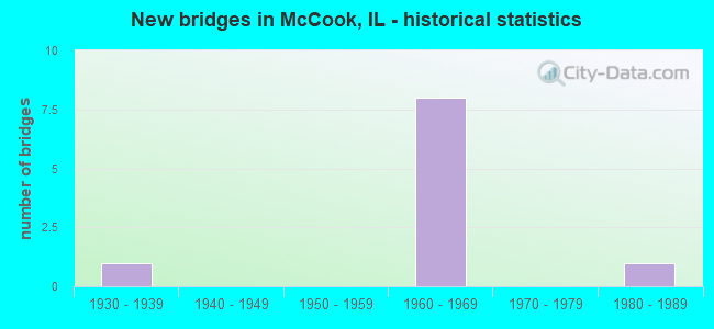
- New bridges - historical statistics
- 11930-1939
- 81960-1969
- 11980-1989

- Reconstructed bridges - Historical Statistics
- 21980-1989
- 11990-1999
- 02000-2009
- 22010-2019


- Bridge Condition - Deck
- 40.0%Very good
- 60.0%Good

- Bridge Condition - Superstructure
- 40.0%Good
- 20.0%Satisfactory
- 20.0%Fair
- 20.0%Serious

- Bridge Condition - Substructure
- 80.0%Good
- 20.0%Satisfactory
Find on map >> Show street view
Structure Number: 160394, Location: 0.2 M NE 55TH ST (Lat: 41.792881, Lng: -87.839694), Route carried "on" structure: Other road , Year Built: 1932, Year Reconstructed: 2003, Status: Open, Structure Length: 7.57m (24.84ft), Average Daily Traffic: 12,500 (year 2018), Truck Traffic: 9%, Average Future Daily Traffic: 18,849 (year 2032), Design Load: HS 20, Features Intersected: RR - CSXT & IHB, Facility Carried by Structure: JOLIET RD
Minimum Vertical Clearance: 30+ m (98+ ft), Kilometerpoint: 6.904, Lanes on structure: 4, Base Highway Network: Yes, Owner: State Highway Agency, Approaching Roadway Width: 15.1m (49.5ft), Material/Design: Steel continuous, Design/Construction: Stringer/Multi-beam, Number Of Spans In Main Unit: 6, Length of Maximum Span: 13.9m (45.6ft), Curb-To-Curb Width: 16.5m (54.1ft), Out-to-Out Width: 17.7m (58.1ft)
Condition: Deck: Good, Superstructure: Satisfactory, Substructure: Satisfactory, Operating Rating: 66.4 metric tons, Method Used To Determine Operating Rating: Load Factor (LF) rating reported by rating factor (RF) method using MS18 loading, Inventory Rating: 39.9 metric tons, Method Used To Determine Inventory Rating: Load Factor (LF) rating reported by rating factor (RF) method using MS18 loading, Structural Evaluation: Equal to present minimum criteria, Deck Geometry: Meets minimum limits, Underclear: Somewhat better than minimum adequacy, Approach Roadway Alignment: Equal to present minimum criteria, Designated Inspection Frequency: Every 24 months, Inspection Date: November 2021, Deck Structure Type: Concrete Cast-file-Place, Wearing Surface/Protective System: Deck Protection: Epoxy Coated Reinforcing
Find on map >> Show street view
Structure Number: 161, Location: 1.3 M N I-55 (Lat: 41.805639, Lng: -87.833292), Route carried "on" structure: State highway 171, Year Built: 1968, Year Reconstructed: 2015, Status: Open, Structure Length: 5.39m (17.68ft), Average Daily Traffic: 38,500 (year 2021), Truck Traffic: 11%, Average Future Daily Traffic: 18,695 (year 2032), Design Load: HS 20, Features Intersected: 47TH ST
Minimum Vertical Clearance: 30+ m (98+ ft), Kilometerpoint: 41.971, Lanes on structure: 2, Lanes under structure: 6, Base Highway Network: Yes, Owner: State Highway Agency, Approaching Roadway Width: 12.2m (40.0ft), Material/Design: Steel continuous, Design/Construction: Stringer/Multi-beam, Number Of Spans In Main Unit: 3, Length of Maximum Span: 30.0m (98.4ft), Curb-To-Curb Width: 12.4m (40.7ft), Out-to-Out Width: 13.4m (44.0ft)
Condition: Deck: Very good, Superstructure: Good, Substructure: Good, Operating Rating: 53.1 metric tons, Method Used To Determine Operating Rating: Load Factor (LF) rating reported by rating factor (RF) method using MS18 loading, Inventory Rating: 41.1 metric tons, Method Used To Determine Inventory Rating: Load Factor (LF) rating reported by rating factor (RF) method using MS18 loading, Structural Evaluation: Better than present minimum criteria, Deck Geometry: Better than present minimum criteria, Underclear: Meets minimum limits, Approach Roadway Alignment: Equal to present desirable criteria, Designated Inspection Frequency: Every 48 months, Inspection Date: October 2021, Deck Structure Type: Concrete Cast-file-Place, Wearing Surface/Protective System: Deck Protection: Epoxy Coated Reinforcing
Find on map >> Show street view
Structure Number: 161001, Location: 1.3 M N I-55 (Lat: 41.805803, Lng: -87.833294), Route carried "on" structure: State highway 171, Year Built: 1968, Year Reconstructed: 2015, Status: Open, Structure Length: 5.39m (17.68ft), Average Daily Traffic: 38,500 (year 2021), Truck Traffic: 11%, Average Future Daily Traffic: 18,695 (year 2032), Design Load: HS 20, Features Intersected: 47TH ST
Minimum Vertical Clearance: 30+ m (98+ ft), Kilometerpoint: 41.987, Lanes on structure: 2, Lanes under structure: 6, Base Highway Network: Yes, Owner: State Highway Agency, Approaching Roadway Width: 12.2m (40.0ft), Material/Design: Steel continuous, Design/Construction: Stringer/Multi-beam, Number Of Spans In Main Unit: 3, Length of Maximum Span: 30.0m (98.4ft), Curb-To-Curb Width: 12.3m (40.4ft), Out-to-Out Width: 13.4m (44.0ft)
Condition: Deck: Very good, Superstructure: Good, Substructure: Good, Operating Rating: 53.1 metric tons, Method Used To Determine Operating Rating: Load Factor (LF) rating reported by rating factor (RF) method using MS18 loading, Inventory Rating: 41.1 metric tons, Method Used To Determine Inventory Rating: Load Factor (LF) rating reported by rating factor (RF) method using MS18 loading, Structural Evaluation: Better than present minimum criteria, Deck Geometry: Better than present minimum criteria, Underclear: Meets minimum limits, Approach Roadway Alignment: Equal to present desirable criteria, Designated Inspection Frequency: Every 48 months, Inspection Date: October 2021, Deck Structure Type: Concrete Cast-file-Place, Wearing Surface/Protective System: Membrane: Built-up, Deck Protection: Epoxy Coated Reinforcing
Find on map >> Show street view
Structure Number: 161005, Location: 0.5 M NW I-55 (Lat: 41.799106, Lng: -87.833039), Route carried "on" structure: State highway 171, Year Built: 1964, Year Reconstructed: 1994, Status: Open, Structure Length: 12.35m (40.52ft), Average Daily Traffic: 38,500 (year 2021), Truck Traffic: 11%, Average Future Daily Traffic: 18,695 (year 2032), Design Load: HS 20, Features Intersected: JOLIET RD&BN RR SPUR
Minimum Vertical Clearance: 30+ m (98+ ft), Kilometerpoint: 41.230, Lanes on structure: 2, Lanes under structure: 5, Base Highway Network: Yes, Owner: State Highway Agency, Approaching Roadway Width: 13.4m (44.0ft), Material/Design: Steel, Design/Construction: Stringer/Multi-beam, Number Of Spans In Main Unit: 6, Length of Maximum Span: 25.1m (82.3ft), Curb-To-Curb Width: 11.0m (36.1ft), Out-to-Out Width: 11.9m (39.0ft)
Condition: Deck: Good, Superstructure: Serious, Substructure: Good, Operating Rating: 47.0 metric tons, Method Used To Determine Operating Rating: Load Factor (LF) rating reported by rating factor (RF) method using MS18 loading, Inventory Rating: 28.2 metric tons, Method Used To Determine Inventory Rating: Load Factor (LF) rating reported by rating factor (RF) method using MS18 loading, Structural Evaluation: High priority of corrective action, Deck Geometry: Equal to present minimum criteria, Underclear: Meets minimum limits, Approach Roadway Alignment: Equal to present desirable criteria, Designated Inspection Frequency: Every 12 months, Inspection Date: July 2021, Deck Structure Type: Concrete Cast-file-Place, Wearing Surface/Protective System: Deck Protection: Epoxy Coated Reinforcing
Find on map >> Show street view
Structure Number: 161006, Location: 0.8 M NW I-55 (Lat: 41.798922, Lng: -87.832933), Route carried "on" structure: State highway 171, Year Built: 1964, Year Reconstructed: 1994, Status: Open, Structure Length: 10.46m (34.32ft), Average Daily Traffic: 38,500 (year 2021), Truck Traffic: 11%, Average Future Daily Traffic: 18,695 (year 2032), Design Load: HS 20, Features Intersected: JOLIET RD&BN RR SPUR
Minimum Vertical Clearance: 30+ m (98+ ft), Kilometerpoint: 41.214, Lanes on structure: 2, Lanes under structure: 5, Base Highway Network: Yes, Owner: State Highway Agency, Approaching Roadway Width: 13.4m (44.0ft), Material/Design: Steel, Design/Construction: Stringer/Multi-beam, Number Of Spans In Main Unit: 6, Length of Maximum Span: 25.1m (82.3ft), Curb-To-Curb Width: 11.0m (36.1ft), Out-to-Out Width: 11.9m (39.0ft)
Condition: Deck: Good, Superstructure: Fair, Substructure: Good, Operating Rating: 63.5 metric tons, Method Used To Determine Operating Rating: Load Factor (LF) rating reported by rating factor (RF) method using MS18 loading, Inventory Rating: 31.4 metric tons, Method Used To Determine Inventory Rating: Load Factor (LF) rating reported by rating factor (RF) method using MS18 loading, Structural Evaluation: Somewhat better than minimum adequacy, Deck Geometry: Equal to present minimum criteria, Underclear: High priority of corrective action, Approach Roadway Alignment: Equal to present desirable criteria, Length Of Structure Improvement: 10.67m (35.01ft), Designated Inspection Frequency: Every 24 months, Inspection Date: April 2020, Bridge Improvement Cost: $882,000, Roadway Improvement Cost: $82,000, Total Project Cost: $1,233,000, Deck Structure Type: Concrete Cast-file-Place, Wearing Surface/Protective System: Deck Protection: Epoxy Coated Reinforcing
Find on map >> Show street view
Structure Number: 162217, Location: 300' N OF 58TH (Lat: 41.786208, Lng: -87.858714), Route carried "on" structure: Other road , Year Built: 1985, Status: Open, Structure Length: 1.28m (4.20ft), Average Daily Traffic: 23,200 (year 2018), Truck Traffic: 11%, Average Future Daily Traffic: 12,360 (year 2032), Features Intersected: DITCH, Facility Carried by Structure: EAST AVE
Minimum Vertical Clearance: 30+ m (98+ ft), Kilometerpoint: 3.460, Lanes on structure: 4, Base Highway Network: Yes, Owner: State Highway Agency, Approaching Roadway Width: 14.6m (47.9ft), Material/Design: Concrete, Design/Construction: Culvert, Number Of Spans In Main Unit: 3, Length of Maximum Span: 4.3m (14.1ft)
Condition: Channel: Good, Culverts: Satisfactory, Operating Rating: 54.1 metric tons, Method Used To Determine Operating Rating: Field evaluation and documented engineering judgment, Inventory Rating: 32.4 metric tons, Method Used To Determine Inventory Rating: Field evaluation and documented engineering judgment, Structural Evaluation: Equal to present minimum criteria, Waterway Adequacy: Better than present minimum criteria, Approach Roadway Alignment: Equal to present desirable criteria, Designated Inspection Frequency: Every 24 months, Inspection Date: October 2020
Find on map >> Show street view
Structure Number: 161, Location: 1.3 M N I-55 (Lat: 41.805814, Lng: -87.832844), Route carried "under" structure: Other road , Year Built: 1968, Structure Length: 0. m, Average Daily Traffic: 6,450 (year 2018), Truck Traffic: 9%, Features Intersected: 47TH ST, Facility Carried by Structure: IL 171 SB
Minimum Vertical Clearance: 4.88m (16.01ft), Kilometerpoint: 7.065, Lanes on structure: 2, Lanes under structure: 6, Material/Design: Steel continuous, Design/Construction: Stringer/Multi-beam, Length of Maximum Span: 30.0m (98.4ft)
Find on map >> Show street view
Structure Number: 161001, Location: 1.3 M N I-55 (Lat: 41.805811, Lng: -87.833000), Route carried "under" structure: Other road , Year Built: 1968, Structure Length: 0. m, Average Daily Traffic: 6,450 (year 2018), Truck Traffic: 9%, Features Intersected: 47TH ST, Facility Carried by Structure: IL 171 NB
Minimum Vertical Clearance: 4.98m (16.34ft), Kilometerpoint: 7.049, Lanes on structure: 2, Lanes under structure: 6, Material/Design: Steel continuous, Design/Construction: Stringer/Multi-beam, Length of Maximum Span: 30.0m (98.4ft)
Find on map >> Show street view
Structure Number: 161005, Location: 0.5 M NW I-55 (Lat: 41.798294, Lng: -87.832592), Route carried "under" structure: Other road , Year Built: 1964, Structure Length: 0. m, Average Daily Traffic: 12,500 (year 2018), Truck Traffic: 9%, Features Intersected: JOLIET RD&BN RR SPUR, Facility Carried by Structure: IL 171 SB
Minimum Vertical Clearance: 6.60m (21.65ft), Kilometerpoint: 7.709, Lanes on structure: 2, Lanes under structure: 5, Material/Design: Steel, Design/Construction: Stringer/Multi-beam, Length of Maximum Span: 25.1m (82.3ft)
Find on map >> Show street view
Structure Number: 161006, Location: 0.8 M NW I-55 (Lat: 41.798569, Lng: -87.832253), Route carried "under" structure: Other road , Year Built: 1964, Structure Length: 0. m, Average Daily Traffic: 12,500 (year 2018), Truck Traffic: 9%, Features Intersected: JOLIET RD&BN RR SPUR, Facility Carried by Structure: IL 171 NB
Minimum Vertical Clearance: 6.55m (21.49ft), Kilometerpoint: 7.757, Lanes on structure: 2, Lanes under structure: 5, Material/Design: Steel, Design/Construction: Stringer/Multi-beam, Length of Maximum Span: 25.1m (82.3ft)