Bridge Statistics for McClure, Pennsylvania (PA)
Condition, Traffic, Stress, Structural Evaluation, Project Costs
- National Bridge Inventory (NBI) Statistics
- 22Number of bridges
- 128ft / 38.6mTotal length
- $4,031,000Total costs
- 25,988Total average daily traffic
- 1,938Total average daily truck traffic
- 38,448Total future (year 2030) average daily traffic
- National Bridge Inventory (NBI) Registered Bridges for McClure
- No street view available for this location
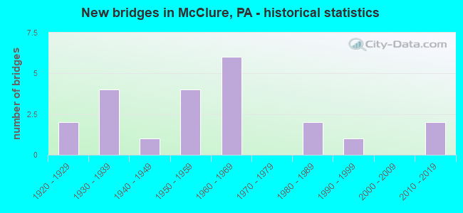
- New bridges - historical statistics
- 21920-1929
- 41930-1939
- 11940-1949
- 41950-1959
- 61960-1969
- 21980-1989
- 11990-1999
- 22010-2019

- Reconstructed bridges - Historical Statistics
- 11970-1979
- 11980-1989
- 01990-1999
- 62000-2009
- 42010-2019


- Bridge Condition - Deck
- 5.3%Excellent
- 31.6%Very good
- 21.1%Good
- 26.3%Satisfactory
- 15.8%Fair

- Bridge Condition - Superstructure
- 35.0%Very good
- 20.0%Good
- 15.0%Satisfactory
- 20.0%Fair
- 5.0%Serious
- 5.0%Critical

- Bridge Condition - Substructure
- 55.0%Good
- 30.0%Satisfactory
- 10.0%Fair
- 5.0%Poor

- Bridge Condition - Channel
- 4.8%Very good
- 9.5%Good
- 19.0%Satisfactory
- 66.7%Fair

- Bridge Condition - Culverts
- 50.0%Very good
- 50.0%Good
Find on map >> Show street view
Structure Number: 5115, Location: MAIN ST.IN MONOCACY (Lat: 40.263344, Lng: -75.767106), Route carried "on" structure: State highway , Year Built: 1932, Year Reconstructed: 2010, Status: Open, Structure Length: 1.83m (6.00ft), Average Daily Traffic: 4,012 (year 2022), Truck Traffic: 4%, Average Future Daily Traffic: 5,986 (year 2032), Design Load: HL 93, Features Intersected: MONOCACY CREEK, Facility Carried by Structure: SR 2047 (LR 663)
Minimum Vertical Clearance: 30+ m (98+ ft), Kilometerpoint: 0.000, Lanes on structure: 2, Owner: State Highway Agency, Approaching Roadway Width: 6.7m (22.0ft), Skew: 1 degrees, Material/Design: Steel, Design/Construction: Stringer/Multi-beam, Number Of Spans In Main Unit: 1, Length of Maximum Span: 17.4m (57.1ft), Curb-To-Curb Width: 6.7m (22.0ft), Out-to-Out Width: 7.7m (25.3ft)
Condition: Deck: Very good, Superstructure: Very good, Substructure: Good, Channel: Fair, Operating Rating: 79.7 metric tons, Method Used To Determine Operating Rating: Assigned ratings based on Load and Resistance Factor Design (LRFD) reported by rating factor (RF) using HL93 loadings, Inventory Rating: 50.2 metric tons, Method Used To Determine Inventory Rating: Assigned ratings based on Load and Resistance Factor Design (LRFD) reported by rating factor (RF) using HL93 loadings, Structural Evaluation: Better than present minimum criteria, Deck Geometry: High priority of replacement, Waterway Adequacy: Better than present minimum criteria, Approach Roadway Alignment: Equal to present desirable criteria, Designated Inspection Frequency: Every 24 months, Inspection Date: November 2020, Bridge Improvement Cost: $25,000, Roadway Improvement Cost: $72,000, Total Project Cost: $332,000, Deck Structure Type: Corrugated Steel, Wearing Surface/Protective System: Wearing Surface: Monolithic Concrete, Deck Protection: Epoxy Coated Reinforcing
Find on map >> Show street view
Structure Number: 7929, Location: NOLF CORNERS (Lat: 40.690939, Lng: -79.709511), Route carried "on" structure: State highway 356, Year Built: 1968, Year Reconstructed: 2007, Status: Open, Structure Length: 8.69m (28.51ft), Average Daily Traffic: 9,146 (year 2022), Truck Traffic: 6%, Average Future Daily Traffic: 15,493 (year 2032), Design Load: HS 20+Mod, Features Intersected: SR0028 NB&SB
Minimum Vertical Clearance: 30+ m (98+ ft), Kilometerpoint: 1.642, Lanes on structure: 2, Lanes under structure: 6, Base Highway Network: Yes, Owner: State Highway Agency, Approaching Roadway Width: 20.7m (67.9ft), Skew: 20 degrees, Material/Design: Prestressed concrete, Design/Construction: Box Beam or Girders - Multiple, Number Of Spans In Main Unit: 2, Number Of Approach Spans: 2, Length of Maximum Span: 30.5m (100.1ft), Curb or Sidewalk Widths: Left: 0.5m (1.6ft), Right: 0.5m (1.6ft), Curb-To-Curb Width: 20.8m (68.2ft), Out-to-Out Width: 25.9m (85.0ft)
Condition: Deck: Good, Superstructure: Fair, Substructure: Satisfactory, Operating Rating: 49.0 metric tons, Method Used To Determine Operating Rating: Load Factor (LF), Inventory Rating: 3.6 metric tons, Method Used To Determine Inventory Rating: Load Factor (LF), Structural Evaluation: High priority of corrective action, Deck Geometry: Superior to present desirable criteria, Underclear: Somewhat better than minimum adequacy, Approach Roadway Alignment: Equal to present desirable criteria, Length Of Structure Improvement: 9.60m (31.50ft), Designated Inspection Frequency: Every 24 months, Inspection Date: March 2021, Bridge Improvement Cost: $77,000, Roadway Improvement Cost: $228,000, Total Project Cost: $1,044,000, Deck Structure Type: Concrete Cast-file-Place, Wearing Surface/Protective System: Wearing Surface: Monolithic Concrete, Deck Protection: Epoxy Coated Reinforcing
Find on map >> Show street view
Structure Number: 18938, Location: 4.5 MI.S.OF ROCKHILL (Lat: 40.180417, Lng: -77.919275), Route carried "on" structure: City street , Year Built: 1985, Year Reconstructed: 2019, Status: Open, Structure Length: 4.05m (13.29ft), Average Daily Traffic: 90 (year 2019), Truck Traffic: 1%, Average Future Daily Traffic: 115 (year 2039), Design Load: HS 25 or greater, Features Intersected: AUGHWICK CREEK, Facility Carried by Structure: T333,MATTHEWS BR.R
Minimum Vertical Clearance: 30+ m (98+ ft), Kilometerpoint: 0.000, Lanes on structure: 2, Owner: County Highway Agency, Approaching Roadway Width: 5.5m (18.0ft), Material/Design: Prestressed concrete, Design/Construction: Box Beam or Girders - Multiple, Number Of Spans In Main Unit: 2, Length of Maximum Span: 19.8m (65.0ft), Curb-To-Curb Width: 7.1m (23.3ft), Out-to-Out Width: 7.7m (25.3ft)
Condition: Deck: Excellent, Superstructure: Fair, Substructure: Good, Channel: Fair, Operating Rating: 61.7 metric tons, Method Used To Determine Operating Rating: Load Factor (LF), Inventory Rating: 19.1 metric tons, Method Used To Determine Inventory Rating: Load Factor (LF), Structural Evaluation: Somewhat better than minimum adequacy, Deck Geometry: Somewhat better than minimum adequacy, Waterway Adequacy: Equal to present minimum criteria, Approach Roadway Alignment: Meets minimum limits, Length Of Structure Improvement: 4.90m (16.08ft), Designated Inspection Frequency: Every 24 months, Inspection Date: December 2019, Deck Structure Type: Concrete Cast-file-Place, Wearing Surface/Protective System: Wearing Surface: Monolithic Concrete, Deck Protection: Epoxy Coated Reinforcing
Find on map >> Show street view
Structure Number: 26542, Location: 3 MILES NORTH EAST WAGNER (Lat: 40.712264, Lng: -77.362947), Route carried "on" structure: State highway , Year Built: 1954, Year Reconstructed: 2017, Status: Open, Structure Length: 1.31m (4.30ft), Average Daily Traffic: 325 (year 2020), Truck Traffic: 9%, Average Future Daily Traffic: 400 (year 2040), Design Load: HL 93, Features Intersected: JACKS CREEK, Facility Carried by Structure: SR 2008
Minimum Vertical Clearance: 30+ m (98+ ft), Kilometerpoint: 3.436, Lanes on structure: 2, Owner: State Highway Agency, Approaching Roadway Width: 7.0m (23.0ft), Material/Design: Steel, Design/Construction: Stringer/Multi-beam, Number Of Spans In Main Unit: 1, Length of Maximum Span: 12.5m (41.0ft), Curb-To-Curb Width: 7.3m (24.0ft), Out-to-Out Width: 8.2m (26.9ft)
Condition: Deck: Very good, Superstructure: Very good, Substructure: Good, Channel: Fair, Operating Rating: 43.4 metric tons, Method Used To Determine Operating Rating: Assigned ratings based on Load and Resistance Factor Design (LRFD) reported by rating factor (RF) using HL93 loadings, Inventory Rating: 33.4 metric tons, Method Used To Determine Inventory Rating: Assigned ratings based on Load and Resistance Factor Design (LRFD) reported by rating factor (RF) using HL93 loadings, Structural Evaluation: Better than present minimum criteria, Deck Geometry: Somewhat better than minimum adequacy, Waterway Adequacy: Better than present minimum criteria, Approach Roadway Alignment: Equal to present minimum criteria, Length Of Structure Improvement: 1.30m (4.27ft), Designated Inspection Frequency: Every 24 months, Inspection Date: June 2020, Bridge Improvement Cost: $31,000, Roadway Improvement Cost: $250,000, Total Project Cost: $421,000, Deck Structure Type: Concrete Cast-file-Place, Wearing Surface/Protective System: Wearing Surface: Monolithic Concrete, Deck Protection: Epoxy Coated Reinforcing
Find on map >> Show street view
Structure Number: 26543, Location: 3 MILES NORTH EAST WAGNER (Lat: 40.709497, Lng: -77.356219), Route carried "on" structure: State highway , Year Built: 1954, Year Reconstructed: 2015, Status: Open, Structure Length: 0.79m (2.59ft), Average Daily Traffic: 325 (year 2020), Truck Traffic: 9%, Average Future Daily Traffic: 295 (year 2040), Design Load: HL 93, Features Intersected: WOLF RUN, Facility Carried by Structure: SR 2008
Minimum Vertical Clearance: 30+ m (98+ ft), Kilometerpoint: 4.237, Lanes on structure: 2, Owner: State Highway Agency, Approaching Roadway Width: 6.1m (20.0ft), Skew: 3 degrees, Material/Design: Steel, Design/Construction: Stringer/Multi-beam, Number Of Spans In Main Unit: 1, Length of Maximum Span: 7.6m (24.9ft), Curb-To-Curb Width: 7.3m (24.0ft), Out-to-Out Width: 8.4m (27.6ft)
Condition: Deck: Very good, Superstructure: Very good, Substructure: Satisfactory, Channel: Fair, Operating Rating: 53.5 metric tons, Method Used To Determine Operating Rating: Assigned ratings based on Load and Resistance Factor Design (LRFD) reported by rating factor (RF) using HL93 loadings, Inventory Rating: 41.1 metric tons, Method Used To Determine Inventory Rating: Assigned ratings based on Load and Resistance Factor Design (LRFD) reported by rating factor (RF) using HL93 loadings, Structural Evaluation: Equal to present minimum criteria, Deck Geometry: Somewhat better than minimum adequacy, Waterway Adequacy: Better than present minimum criteria, Approach Roadway Alignment: Equal to present desirable criteria, Length Of Structure Improvement: 0.80m (2.62ft), Designated Inspection Frequency: Every 24 months, Inspection Date: June 2020, Bridge Improvement Cost: $26,000, Roadway Improvement Cost: $237,000, Total Project Cost: $349,000, Deck Structure Type: Concrete Cast-file-Place, Wearing Surface/Protective System: Wearing Surface: Monolithic Concrete, Deck Protection: Epoxy Coated Reinforcing
Find on map >> Show street view
Structure Number: 26624, Location: 250 FT NORTHEAST OF T460 (Lat: 40.717594, Lng: -77.366125), Route carried "on" structure: City street , Year Built: 1935, Status: Posted for load, Structure Length: 1.13m (3.71ft), Average Daily Traffic: 150 (year 2021), Average Future Daily Traffic: 220 (year 2041), Design Load: HS 20, Features Intersected: TRIB OF JACKS CREEK, Facility Carried by Structure: T-393, DECATUR RD.
Minimum Vertical Clearance: 30+ m (98+ ft), Kilometerpoint: 0.000, Lanes on structure: 2, Owner: Town or Township Highway Agency, Approaching Roadway Width: 5.8m (19.0ft), Skew: 4 degrees, Material/Design: Steel, Design/Construction: Stringer/Multi-beam, Number Of Spans In Main Unit: 1, Length of Maximum Span: 11.0m (36.1ft), Curb or Sidewalk Widths: Left: 0.2m (0.7ft), Right: 0.2m (0.7ft), Curb-To-Curb Width: 6.7m (22.0ft), Out-to-Out Width: 7.2m (23.6ft)
Condition: Deck: Satisfactory, Superstructure: Satisfactory, Substructure: Fair, Channel: Fair, Operating Rating: 38.1 metric tons, Method Used To Determine Operating Rating: Load Factor (LF), Inventory Rating: 22.7 metric tons, Method Used To Determine Inventory Rating: Load Factor (LF), Structural Evaluation: Somewhat better than minimum adequacy, Deck Geometry: Meets minimum limits, Waterway Adequacy: Better than present minimum criteria, Approach Roadway Alignment: Equal to present desirable criteria, Bridge Posting: Required (Relationship of Operating Rating to Maximum Legal Load: 10.0 - 19.9% below), Length Of Structure Improvement: 1.10m (3.61ft), Designated Inspection Frequency: Every 24 months, Other Special Inspection Frequency: Every 12 months, Inspection Date: March 2021, Other Special Inspection Date: March 2021, Bridge Improvement Cost: $1,000, Roadway Improvement Cost: $4,000, Total Project Cost: $16,000, Deck Structure Type: Open Grating
Find on map >> Show street view
Structure Number: 31107, Location: BOROUGH OF MCCLURE (Lat: 40.708733, Lng: -77.316700), Route carried "on" structure: US 522, Year Built: 1927, Status: Open, Structure Length: 1.07m (3.51ft), Average Daily Traffic: 2,888 (year 2020), Truck Traffic: 13%, Average Future Daily Traffic: 3,463 (year 2032), Features Intersected: SOUTH BRANCH MIDDLE CRK
Minimum Vertical Clearance: 30+ m (98+ ft), Kilometerpoint: 2.469, Lanes on structure: 2, Base Highway Network: Yes, Owner: State Highway Agency, Approaching Roadway Width: 7.0m (23.0ft), Skew: 1 degrees, Material/Design: Concrete, Design/Construction: Tee Beam, Number Of Spans In Main Unit: 1, Length of Maximum Span: 10.4m (34.1ft), Curb or Sidewalk Widths: Left: 0.2m (0.7ft), Right: 0.9m (3.0ft), Curb-To-Curb Width: 8.2m (26.9ft), Out-to-Out Width: 9.9m (32.5ft)
Condition: Deck: Fair, Superstructure: Fair, Substructure: Fair, Channel: Fair, Operating Rating: 49.9 metric tons, Method Used To Determine Operating Rating: Load Factor (LF), Inventory Rating: 29.9 metric tons, Method Used To Determine Inventory Rating: Load Factor (LF), Structural Evaluation: Somewhat better than minimum adequacy, Deck Geometry: High priority of corrective action, Waterway Adequacy: Equal to present minimum criteria, Approach Roadway Alignment: Equal to present desirable criteria, Length Of Structure Improvement: 1.10m (3.61ft), Designated Inspection Frequency: Every 24 months, Inspection Date: Febuary 2020, Bridge Improvement Cost: $10,000, Roadway Improvement Cost: $50,000, Total Project Cost: $129,000, Deck Structure Type: Concrete Cast-file-Place, Wearing Surface/Protective System: Wearing Surface: Bituminous
Find on map >> Show street view
Structure Number: 3124, Location: VILLAGE OF MCCLURE (Lat: 40.707567, Lng: -77.317767), Route carried "on" structure: State highway , Year Built: 1965, Year Reconstructed: 2009, Status: Open, Structure Length: 1.22m (4.00ft), Average Daily Traffic: 274 (year 2022), Truck Traffic: 4%, Average Future Daily Traffic: 342 (year 2032), Design Load: H 20, Features Intersected: SOUTH BRANCH MIDDLE CRK, Facility Carried by Structure: MOUNTAIN DALE RD
Minimum Vertical Clearance: 30+ m (98+ ft), Kilometerpoint: 0.000, Lanes on structure: 2, Owner: State Highway Agency, Approaching Roadway Width: 6.1m (20.0ft), Skew: 4 degrees, Material/Design: Prestressed concrete, Design/Construction: Box Beam or Girders - Multiple, Number Of Spans In Main Unit: 1, Length of Maximum Span: 11.6m (38.1ft), Curb or Sidewalk Widths: Left: 0.4m (1.3ft), Right: 1.4m (4.6ft), Curb-To-Curb Width: 9.2m (30.2ft), Out-to-Out Width: 11.9m (39.0ft)
Condition: Deck: Good, Superstructure: Good, Substructure: Good, Channel: Satisfactory, Operating Rating: 91.6 metric tons, Method Used To Determine Operating Rating: Load Factor (LF), Inventory Rating: 26.3 metric tons, Method Used To Determine Inventory Rating: Load Factor (LF), Structural Evaluation: Equal to present minimum criteria, Deck Geometry: Equal to present minimum criteria, Waterway Adequacy: Better than present minimum criteria, Approach Roadway Alignment: Equal to present desirable criteria, Length Of Structure Improvement: 1.90m (6.23ft), Designated Inspection Frequency: Every 24 months, Inspection Date: Febuary 2020, Wearing Surface/Protective System: Wearing Surface: Monolithic Concrete, Deck Protection: Epoxy Coated Reinforcing
Find on map >> Show street view
Structure Number: 31241, Location: VILLAGE OF MCCLURE (Lat: 40.709972, Lng: -77.317503), Route carried "on" structure: State highway , Year Built: 1948, Status: Open, Structure Length: 1.34m (4.40ft), Average Daily Traffic: 817 (year 2022), Truck Traffic: 8%, Average Future Daily Traffic: 1,513 (year 2032), Features Intersected: SOUTH BRANCH MIDDLE CRK, Facility Carried by Structure: MOUNTAIN DALE RD
Minimum Vertical Clearance: 30+ m (98+ ft), Kilometerpoint: 0.332, Lanes on structure: 2, Owner: State Highway Agency, Approaching Roadway Width: 5.8m (19.0ft), Material/Design: Concrete, Design/Construction: Tee Beam, Number Of Spans In Main Unit: 1, Length of Maximum Span: 12.8m (42.0ft), Curb or Sidewalk Widths: Left: 0.2m (0.7ft), Right: 0.2m (0.7ft), Curb-To-Curb Width: 9.0m (29.5ft), Out-to-Out Width: 10.2m (33.5ft)
Condition: Deck: Satisfactory, Superstructure: Satisfactory, Substructure: Good, Channel: Satisfactory, Operating Rating: 49.0 metric tons, Method Used To Determine Operating Rating: Load Factor (LF), Inventory Rating: 29.0 metric tons, Method Used To Determine Inventory Rating: Load Factor (LF), Structural Evaluation: Equal to present minimum criteria, Deck Geometry: Somewhat better than minimum adequacy, Waterway Adequacy: Better than present minimum criteria, Approach Roadway Alignment: Equal to present desirable criteria, Length Of Structure Improvement: 2.00m (6.56ft), Designated Inspection Frequency: Every 24 months, Inspection Date: Febuary 2020, Bridge Improvement Cost: $5,000, Roadway Improvement Cost: $14,000, Total Project Cost: $65,000, Deck Structure Type: Concrete Cast-file-Place, Wearing Surface/Protective System: Wearing Surface: Bituminous, Membrane: Preformed Fabric
Find on map >> Show street view
Structure Number: 31242, Location: 1 MI NE OF MCCLURE (Lat: 40.721956, Lng: -77.309514), Route carried "on" structure: State highway , Year Built: 1952, Year Reconstructed: 2008, Status: Open, Structure Length: 1.37m (4.49ft), Average Daily Traffic: 756 (year 2022), Truck Traffic: 8%, Average Future Daily Traffic: 1,433 (year 2032), Design Load: HL 93, Features Intersected: S BR MIDDLE CREEK, Facility Carried by Structure: MOUNTAIN DALE RD
Minimum Vertical Clearance: 30+ m (98+ ft), Kilometerpoint: 1.999, Lanes on structure: 2, Owner: State Highway Agency, Approaching Roadway Width: 7.0m (23.0ft), Skew: 3 degrees, Material/Design: Prestressed concrete, Design/Construction: Box Beam or Girders - Single/Spread, Number Of Spans In Main Unit: 1, Length of Maximum Span: 12.8m (42.0ft), Curb-To-Curb Width: 9.8m (32.2ft), Out-to-Out Width: 10.5m (34.4ft)
Condition: Deck: Very good, Superstructure: Very good, Substructure: Good, Channel: Fair, Operating Rating: 60.8 metric tons, Method Used To Determine Operating Rating: Load and Resistance Factor (LRFR), Inventory Rating: 46.3 metric tons, Method Used To Determine Inventory Rating: Load and Resistance Factor (LRFR), Structural Evaluation: Better than present minimum criteria, Deck Geometry: Equal to present minimum criteria, Waterway Adequacy: Superior to present desirable criteria, Approach Roadway Alignment: Somewhat better than minimum adequacy, Length Of Structure Improvement: 1.40m (4.59ft), Designated Inspection Frequency: Every 48 months, Inspection Date: Febuary 2020, Bridge Improvement Cost: $42,000, Roadway Improvement Cost: $124,000, Total Project Cost: $569,000, Deck Structure Type: Concrete Cast-file-Place, Wearing Surface/Protective System: Wearing Surface: Monolithic Concrete, Deck Protection: Epoxy Coated Reinforcing
Find on map >> Show street view
Structure Number: 31249, Location: 2 MI NE OF MCCLURE (Lat: 40.725631, Lng: -77.305358), Route carried "on" structure: State highway , Year Built: 1962, Status: Open, Structure Length: 1.62m (5.31ft), Average Daily Traffic: 288 (year 2020), Truck Traffic: 8%, Average Future Daily Traffic: 295 (year 2032), Design Load: H 20, Features Intersected: MIDDLE CREEK, Facility Carried by Structure: MIDDLE RD
Minimum Vertical Clearance: 30+ m (98+ ft), Kilometerpoint: 0.000, Lanes on structure: 2, Owner: State Highway Agency, Approaching Roadway Width: 5.5m (18.0ft), Skew: 1 degrees, Material/Design: Steel, Design/Construction: Stringer/Multi-beam, Number Of Spans In Main Unit: 1, Length of Maximum Span: 15.2m (49.9ft), Curb or Sidewalk Widths: Left: 0.5m (1.6ft), Right: 0.5m (1.6ft), Curb-To-Curb Width: 9.1m (29.9ft), Out-to-Out Width: 10.8m (35.4ft)
Condition: Deck: Satisfactory, Superstructure: Good, Substructure: Satisfactory, Channel: Fair, Operating Rating: 78.0 metric tons, Method Used To Determine Operating Rating: Load Factor (LF), Inventory Rating: 47.2 metric tons, Method Used To Determine Inventory Rating: Load Factor (LF), Structural Evaluation: Equal to present minimum criteria, Deck Geometry: Equal to present minimum criteria, Waterway Adequacy: Better than present minimum criteria, Approach Roadway Alignment: Equal to present desirable criteria, Length Of Structure Improvement: 2.30m (7.55ft), Designated Inspection Frequency: Every 48 months, Inspection Date: Febuary 2020, Bridge Improvement Cost: $3,000, Roadway Improvement Cost: $8,000, Total Project Cost: $38,000, Deck Structure Type: Concrete Cast-file-Place, Wearing Surface/Protective System: Wearing Surface: Bituminous, Membrane: Preformed Fabric
Find on map >> Show street view
Structure Number: 3125, Location: 2 MI NE MCCLURE BORO (Lat: 40.731497, Lng: -77.295683), Route carried "on" structure: State highway , Year Built: 1966, Status: Open, Structure Length: 1.80m (5.91ft), Average Daily Traffic: 288 (year 2020), Truck Traffic: 8%, Average Future Daily Traffic: 295 (year 2032), Design Load: H 20, Features Intersected: MIDDLE CREEK, Facility Carried by Structure: MIDDLE RD
Minimum Vertical Clearance: 30+ m (98+ ft), Kilometerpoint: 0.879, Lanes on structure: 2, Owner: State Highway Agency, Approaching Roadway Width: 5.8m (19.0ft), Skew: 3 degrees, Material/Design: Steel, Design/Construction: Stringer/Multi-beam, Number Of Spans In Main Unit: 1, Length of Maximum Span: 17.7m (58.1ft), Curb or Sidewalk Widths: Left: 0.5m (1.6ft), Right: 0.5m (1.6ft), Curb-To-Curb Width: 8.4m (27.6ft), Out-to-Out Width: 10.4m (34.1ft)
Condition: Deck: Good, Superstructure: Good, Substructure: Good, Channel: Fair, Operating Rating: 67.1 metric tons, Method Used To Determine Operating Rating: Load Factor (LF), Inventory Rating: 39.9 metric tons, Method Used To Determine Inventory Rating: Load Factor (LF), Structural Evaluation: Better than present minimum criteria, Deck Geometry: Somewhat better than minimum adequacy, Waterway Adequacy: Superior to present desirable criteria, Approach Roadway Alignment: Better than present minimum criteria, Length Of Structure Improvement: 2.50m (8.20ft), Designated Inspection Frequency: Every 24 months, Other Special Inspection Frequency: Every 12 months, Inspection Date: Febuary 2021, Other Special Inspection Date: Febuary 2021, Deck Structure Type: Concrete Cast-file-Place, Wearing Surface/Protective System: Wearing Surface: Bituminous, Membrane: Preformed Fabric
Find on map >> Show street view
Structure Number: 31251, Location: 3 MI NE OF MCCLURE BORO (Lat: 40.736922, Lng: -77.278253), Route carried "on" structure: State highway , Year Built: 1960, Year Reconstructed: 2013, Status: Open, Structure Length: 1.74m (5.71ft), Average Daily Traffic: 288 (year 2020), Truck Traffic: 8%, Average Future Daily Traffic: 295 (year 2032), Design Load: HL 93, Features Intersected: SOUTH BRANCH MIDDLE CRK, Facility Carried by Structure: MIDDLE RD
Minimum Vertical Clearance: 30+ m (98+ ft), Kilometerpoint: 2.768, Lanes on structure: 2, Owner: State Highway Agency, Approaching Roadway Width: 5.2m (17.1ft), Skew: 1 degrees, Material/Design: Prestressed concrete, Design/Construction: Box Beam or Girders - Multiple, Number Of Spans In Main Unit: 1, Length of Maximum Span: 15.2m (49.9ft), Curb or Sidewalk Widths: Left: 0.5m (1.6ft), Right: 0.5m (1.6ft), Curb-To-Curb Width: 9.1m (29.9ft), Out-to-Out Width: 10.9m (35.8ft)
Condition: Deck: Very good, Superstructure: Very good, Substructure: Good, Channel: Fair, Operating Rating: 54.8 metric tons, Method Used To Determine Operating Rating: Assigned ratings based on Load and Resistance Factor Design (LRFD) reported by rating factor (RF) using HL93 loadings, Inventory Rating: 42.1 metric tons, Method Used To Determine Inventory Rating: Assigned ratings based on Load and Resistance Factor Design (LRFD) reported by rating factor (RF) using HL93 loadings, Structural Evaluation: Better than present minimum criteria, Deck Geometry: Equal to present minimum criteria, Waterway Adequacy: Better than present minimum criteria, Approach Roadway Alignment: Equal to present desirable criteria, Length Of Structure Improvement: 1.60m (5.25ft), Designated Inspection Frequency: Every 48 months, Inspection Date: Febuary 2020, Bridge Improvement Cost: $19,000, Roadway Improvement Cost: $55,000, Total Project Cost: $253,000, Deck Structure Type: Concrete Cast-file-Place, Wearing Surface/Protective System: Wearing Surface: Epoxy Overlay, Deck Protection: Epoxy Coated Reinforcing
Find on map >> Show street view
Structure Number: 31252, Location: 3 MI W OF BEAVER SPRINGS (Lat: 40.741983, Lng: -77.266700), Route carried "on" structure: State highway , Year Built: 1961, Year Reconstructed: 2007, Status: Open, Structure Length: 1.83m (6.00ft), Average Daily Traffic: 288 (year 2020), Truck Traffic: 8%, Average Future Daily Traffic: 295 (year 2032), Design Load: HL 93, Features Intersected: SOUTH BR MIDDLE CREEK, Facility Carried by Structure: MIDDLE RD
Minimum Vertical Clearance: 30+ m (98+ ft), Kilometerpoint: 3.626, Lanes on structure: 2, Owner: State Highway Agency, Approaching Roadway Width: 5.8m (19.0ft), Skew: 1 degrees, Material/Design: Steel, Design/Construction: Stringer/Multi-beam, Number Of Spans In Main Unit: 1, Length of Maximum Span: 17.7m (58.1ft), Curb-To-Curb Width: 9.2m (30.2ft), Out-to-Out Width: 9.8m (32.2ft)
Condition: Deck: Very good, Superstructure: Very good, Substructure: Good, Channel: Fair, Operating Rating: 69.9 metric tons, Method Used To Determine Operating Rating: Load Factor (LF), Inventory Rating: 41.7 metric tons, Method Used To Determine Inventory Rating: Load Factor (LF), Structural Evaluation: Better than present minimum criteria, Deck Geometry: Equal to present minimum criteria, Waterway Adequacy: Superior to present desirable criteria, Approach Roadway Alignment: Equal to present desirable criteria, Length Of Structure Improvement: 1.80m (5.91ft), Designated Inspection Frequency: Every 48 months, Inspection Date: Febuary 2020, Bridge Improvement Cost: $17,000, Roadway Improvement Cost: $29,000, Total Project Cost: $196,000, Deck Structure Type: Concrete Cast-file-Place, Wearing Surface/Protective System: Wearing Surface: Epoxy Overlay, Deck Protection: Epoxy Coated Reinforcing
Find on map >> Show street view
Structure Number: 31257, Location: VILLAGE OF BANNERVILLE (Lat: 40.732583, Lng: -77.354336), Route carried "on" structure: State highway , Year Built: 1953, Year Reconstructed: 2007, Status: Open, Structure Length: 1.01m (3.31ft), Average Daily Traffic: 414 (year 2022), Truck Traffic: 9%, Average Future Daily Traffic: 489 (year 2032), Features Intersected: OVER ULSH GAP RUN, Facility Carried by Structure: STAGE RD
Minimum Vertical Clearance: 30+ m (98+ ft), Kilometerpoint: 0.003, Lanes on structure: 2, Owner: State Highway Agency, Approaching Roadway Width: 5.2m (17.1ft), Material/Design: Concrete, Design/Construction: Channel Beam, Number Of Spans In Main Unit: 1, Length of Maximum Span: 9.8m (32.2ft), Curb-To-Curb Width: 9.0m (29.5ft), Out-to-Out Width: 10.0m (32.8ft)
Condition: Superstructure: Good, Substructure: Good, Channel: Fair, Inventory Rating: 75.3 metric tons, Method Used To Determine Inventory Rating: Load Factor (LF), Structural Evaluation: Better than present minimum criteria, Deck Geometry: Somewhat better than minimum adequacy, Waterway Adequacy: Better than present minimum criteria, Approach Roadway Alignment: Equal to present desirable criteria, Length Of Structure Improvement: 1.60m (5.25ft), Designated Inspection Frequency: Every 48 months, Inspection Date: Febuary 2020, Bridge Improvement Cost: $6,000, Roadway Improvement Cost: $18,000, Total Project Cost: $83,000, Wearing Surface/Protective System: Wearing Surface: Bituminous, Membrane: Preformed Fabric
Find on map >> Show street view
Structure Number: 31263, Location: 4.5 MI W OF BENFER (Lat: 40.766822, Lng: -77.292353), Route carried "on" structure: State highway , Year Built: 1939, Status: Open, Structure Length: 0.67m (2.20ft), Average Daily Traffic: 334 (year 2022), Truck Traffic: 16%, Average Future Daily Traffic: 546 (year 2032), Features Intersected: KREB GAP RUN, Facility Carried by Structure: SR 4012
Minimum Vertical Clearance: 30+ m (98+ ft), Kilometerpoint: 3.112, Lanes on structure: 2, Owner: State Highway Agency, Approaching Roadway Width: 5.8m (19.0ft), Skew: 2 degrees, Material/Design: Concrete, Design/Construction: Slab, Number Of Spans In Main Unit: 1, Length of Maximum Span: 6.1m (20.0ft), Curb or Sidewalk Widths: Left: 0.1m (0.3ft), Right: 0.1m (0.3ft), Curb-To-Curb Width: 7.0m (23.0ft), Out-to-Out Width: 7.9m (25.9ft)
Condition: Deck: Fair, Superstructure: Fair, Substructure: Satisfactory, Channel: Satisfactory, Operating Rating: 54.4 metric tons, Method Used To Determine Operating Rating: Field evaluation and documented engineering judgment, Inventory Rating: 32.7 metric tons, Method Used To Determine Inventory Rating: Field evaluation and documented engineering judgment, Structural Evaluation: Somewhat better than minimum adequacy, Deck Geometry: Meets minimum limits, Waterway Adequacy: Superior to present desirable criteria, Approach Roadway Alignment: Equal to present desirable criteria, Length Of Structure Improvement: 0.70m (2.30ft), Designated Inspection Frequency: Every 24 months, Inspection Date: Febuary 2020, Bridge Improvement Cost: $6,000, Roadway Improvement Cost: $50,000, Total Project Cost: $78,000, Wearing Surface/Protective System: Wearing Surface: Bituminous, Membrane: Preformed Fabric
Find on map >> Show street view
Structure Number: 3131, Location: 0.5 MI.S OF BANNERVILLE (Lat: 40.726244, Lng: -77.349942), Route carried "on" structure: City street , Year Built: 1981, Status: Open, Structure Length: 1.58m (5.18ft), Average Daily Traffic: 150 (year 2009), Truck Traffic: 10%, Average Future Daily Traffic: 232 (year 2031), Features Intersected: OVER JACKS CREEK, Facility Carried by Structure: DECATUR RD T457
Minimum Vertical Clearance: 30+ m (98+ ft), Kilometerpoint: 0.000, Lanes on structure: 2, Owner: Town or Township Highway Agency, Approaching Roadway Width: 7.0m (23.0ft), Skew: 1 degrees, Material/Design: Wood or Timber, Number Of Spans In Main Unit: 2, Length of Maximum Span: 7.3m (24.0ft), Curb-To-Curb Width: 7.6m (24.9ft), Out-to-Out Width: 7.9m (25.9ft)
Condition: Deck: Satisfactory, Superstructure: Satisfactory, Substructure: Satisfactory, Channel: Satisfactory, Operating Rating: 78.0 metric tons, Method Used To Determine Operating Rating: Allowable Stress (AS), Inventory Rating: 58.1 metric tons, Method Used To Determine Inventory Rating: Allowable Stress (AS), Structural Evaluation: Equal to present minimum criteria, Deck Geometry: Somewhat better than minimum adequacy, Waterway Adequacy: Better than present minimum criteria, Approach Roadway Alignment: Equal to present desirable criteria, Length Of Structure Improvement: 1.60m (5.25ft), Designated Inspection Frequency: Every 24 months, Inspection Date: August 2021, Wearing Surface/Protective System: Wearing Surface: Bituminous
Find on map >> Show street view
Structure Number: 31311, Location: 2 MI.SW.OF MIDDLE CREEK (Lat: 40.752156, Lng: -77.292589), Route carried "on" structure: City street , Year Built: 1925, Year Reconstructed: 1983, Status: Posted for load, Structure Length: 1.01m (3.31ft), Average Daily Traffic: 50 (year 2009), Truck Traffic: 5%, Average Future Daily Traffic: 77 (year 2030), Features Intersected: ULSH GAP RUN, Facility Carried by Structure: W.BEAVER TWP T467
Minimum Vertical Clearance: 30+ m (98+ ft), Kilometerpoint: 0.000, Lanes on structure: 1, Owner: Town or Township Highway Agency, Approaching Roadway Width: 4.0m (13.1ft), Material/Design: Steel, Design/Construction: Stringer/Multi-beam, Number Of Spans In Main Unit: 1, Length of Maximum Span: 7.9m (25.9ft), Curb-To-Curb Width: 5.3m (17.4ft), Out-to-Out Width: 5.5m (18.0ft)
Condition: Deck: Fair, Superstructure: Serious, Substructure: Poor, Channel: Fair, Operating Rating: 68.9 metric tons, Method Used To Determine Operating Rating: Load Factor (LF), Inventory Rating: 40.8 metric tons, Method Used To Determine Inventory Rating: Load Factor (LF), Structural Evaluation: High priority of corrective action, Deck Geometry: High priority of corrective action, Waterway Adequacy: Better than present minimum criteria, Approach Roadway Alignment: Equal to present desirable criteria, Length Of Structure Improvement: 1.00m (3.28ft), Designated Inspection Frequency: Every 24 months, Other Special Inspection Frequency: Every 6 months, Inspection Date: August 2021, Other Special Inspection Date: August 2021, Bridge Improvement Cost: $16,000, Roadway Improvement Cost: $50,000, Total Project Cost: $217,000, Deck Structure Type: Open Grating
Find on map >> Show street view
Structure Number: 31312, Location: .5 MI.N OF MCCLURE (Lat: 40.727956, Lng: -77.303356), Route carried "on" structure: City street , Year Built: 1930, Year Reconstructed: 1985, Status: Closed, Structure Length: 1.16m (3.81ft), Average Daily Traffic: 75 (year 2009), Truck Traffic: 5%, Average Future Daily Traffic: 116 (year 2030), Features Intersected: S BR OF MIDDLE CREEK, Facility Carried by Structure: STEELEY RD. T548
Minimum Vertical Clearance: 30+ m (98+ ft), Kilometerpoint: 0.000, Lanes on structure: 1, Owner: Town or Township Highway Agency, Approaching Roadway Width: 3.7m (12.1ft), Material/Design: Steel, Design/Construction: Stringer/Multi-beam, Number Of Spans In Main Unit: 1, Length of Maximum Span: 10.1m (33.1ft), Curb-To-Curb Width: 4.4m (14.4ft), Out-to-Out Width: 4.6m (15.1ft)
Condition: Deck: Satisfactory, Superstructure: Critical, Substructure: Satisfactory, Channel: Fair, Operating Rating: 21.8 metric tons, Method Used To Determine Operating Rating: Load Factor (LF), Inventory Rating: 12.7 metric tons, Method Used To Determine Inventory Rating: Load Factor (LF), Structural Evaluation: High priority of replacement, Deck Geometry: Equal to present minimum criteria, Waterway Adequacy: Better than present minimum criteria, Approach Roadway Alignment: Somewhat better than minimum adequacy, Bridge Posting: Required (Relationship of Operating Rating to Maximum Legal Load: > 39.9% below), Length Of Structure Improvement: 1.20m (3.94ft), Designated Inspection Frequency: Every 24 months, Inspection Date: August 2021, Bridge Improvement Cost: $18,000, Roadway Improvement Cost: $52,000, Total Project Cost: $241,000, Deck Structure Type: Open Grating
Find on map >> Show street view
Structure Number: 39508, Location: 2 MI N MCALISTERVILLE (Lat: 40.677950, Lng: -77.293556), Route carried "on" structure: State highway 235, Year Built: 1997, Status: Open, Structure Length: 0.85m (2.79ft), Average Daily Traffic: 1,085 (year 2020), Truck Traffic: 11%, Average Future Daily Traffic: 1,287 (year 2041), Design Load: HS 25 or greater, Features Intersected: LOST CREEK
Minimum Vertical Clearance: 30+ m (98+ ft), Kilometerpoint: 29.865, Lanes on structure: 2, Owner: State Highway Agency, Approaching Roadway Width: 6.7m (22.0ft), Skew: 3 degrees, Material/Design: Concrete, Design/Construction: Culvert, Number Of Spans In Main Unit: 1, Length of Maximum Span: 8.5m (27.9ft)
Condition: Channel: Very good, Culverts: Good, Inventory Rating: 74.4 metric tons, Method Used To Determine Inventory Rating: Load Factor (LF), Structural Evaluation: Better than present minimum criteria, Waterway Adequacy: Equal to present desirable criteria, Approach Roadway Alignment: Equal to present desirable criteria, Length Of Structure Improvement: 1.50m (4.92ft), Designated Inspection Frequency: Every 24 months, Inspection Date: October 2021
Find on map >> Show street view
Structure Number: 48104, Location: 3 MI W OF BEAVER SPRINGS (Lat: 40.725344, Lng: -77.269344), Route carried "on" structure: US 522, Year Built: 2013, Status: Open, Structure Length: 1.74m (5.71ft), Average Daily Traffic: 3,611 (year 2021), Truck Traffic: 8%, Average Future Daily Traffic: 4,846 (year 2034), Design Load: HL 93, Features Intersected: BEAVER CREEK
Minimum Vertical Clearance: 30+ m (98+ ft), Kilometerpoint: 6.402, Lanes on structure: 2, Base Highway Network: Yes, Owner: State Highway Agency, Approaching Roadway Width: 8.5m (27.9ft), Skew: 4 degrees, Material/Design: Prestressed concrete, Design/Construction: Box Beam or Girders - Single/Spread, Number Of Spans In Main Unit: 1, Length of Maximum Span: 16.8m (55.1ft), Curb or Sidewalk Widths: Left: 0.2m (0.7ft), Right: 0.2m (0.7ft), Curb-To-Curb Width: 12.2m (40.0ft), Out-to-Out Width: 13.2m (43.3ft)
Condition: Deck: Good, Superstructure: Very good, Substructure: Good, Channel: Good, Operating Rating: 63.8 metric tons, Method Used To Determine Operating Rating: Assigned ratings based on Load and Resistance Factor Design (LRFD) reported by rating factor (RF) using HL93 loadings, Inventory Rating: 39.5 metric tons, Method Used To Determine Inventory Rating: Assigned ratings based on Load and Resistance Factor Design (LRFD) reported by rating factor (RF) using HL93 loadings, Structural Evaluation: Better than present minimum criteria, Deck Geometry: Equal to present minimum criteria, Waterway Adequacy: Equal to present desirable criteria, Approach Roadway Alignment: Equal to present desirable criteria, Designated Inspection Frequency: Every 48 months, Inspection Date: Febuary 2020, Deck Structure Type: Concrete Cast-file-Place, Wearing Surface/Protective System: Wearing Surface: Monolithic Concrete, Deck Protection: Epoxy Coated Reinforcing
Find on map >> Show street view
Structure Number: 52707, Location: 2 MI NE OF BANNERVILLE (Lat: 40.758200, Lng: -77.314811), Route carried "on" structure: State highway , Year Built: 2015, Status: Open, Structure Length: 0.76m (2.49ft), Average Daily Traffic: 334 (year 2022), Truck Traffic: 16%, Average Future Daily Traffic: 415 (year 2038), Design Load: HL 93, Features Intersected: TRIBUTARY ULSH GAP RUN, Facility Carried by Structure: SR 4012
Minimum Vertical Clearance: 30+ m (98+ ft), Kilometerpoint: 0.959, Lanes on structure: 2, Owner: State Highway Agency, Approaching Roadway Width: 6.1m (20.0ft), Material/Design: Concrete, Design/Construction: Culvert, Number Of Spans In Main Unit: 1, Length of Maximum Span: 7.6m (24.9ft), Curb or Sidewalk Widths: Left: 0.6m (2.0ft), Right: 0.6m (2.0ft)
Condition: Channel: Good, Culverts: Very good, Operating Rating: 57.0 metric tons, Method Used To Determine Operating Rating: Assigned ratings based on Load and Resistance Factor Design (LRFD) reported by rating factor (RF) using HL93 loadings, Inventory Rating: 35.6 metric tons, Method Used To Determine Inventory Rating: Assigned ratings based on Load and Resistance Factor Design (LRFD) reported by rating factor (RF) using HL93 loadings, Structural Evaluation: Equal to present desirable criteria, Waterway Adequacy: Better than present minimum criteria, Approach Roadway Alignment: Equal to present desirable criteria, Designated Inspection Frequency: Every 48 months, Inspection Date: Febuary 2020, Wearing Surface/Protective System: Wearing Surface: Bituminous, Membrane: Preformed Fabric, Deck Protection: Epoxy Coated Reinforcing