Bridge Statistics for McCammon, Idaho (ID)
Condition, Traffic, Stress, Structural Evaluation, Project Costs
- National Bridge Inventory (NBI) Statistics
- 15Number of bridges
- 240ft / 73.0mTotal length
- 75,458Total average daily traffic
- 15,375Total average daily truck traffic
- National Bridge Inventory (NBI) Registered Bridges for McCammon
- No street view available for this location
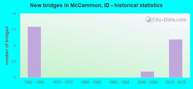
- New bridges - historical statistics
- 81960-1969
- 12000-2009
- 62010-2019

- Reconstructed bridges - Historical Statistics
- 21990-1999
- 02000-2009
- 22010-2019


- Bridge Condition - Deck
- 9.1%Very good
- 81.8%Good
- 9.1%Satisfactory

- Bridge Condition - Superstructure
- 9.1%Very good
- 45.5%Good
- 27.3%Satisfactory
- 18.2%Fair

- Bridge Condition - Substructure
- 36.4%Very good
- 36.4%Good
- 18.2%Satisfactory
- 9.1%Fair

- Bridge Condition - Channel
- 83.3%Very good
- 16.7%Fair
Find on map >> Show street view
Structure Number: 1112, Location: 2.8 S. MCCAMMON (Lat: 42.641964, Lng: -112.206067), Route carried "on" structure: Interstate 15, Year Built: 1964, Year Reconstructed: 2019, Status: Open, Structure Length: 4.11m (13.48ft), Average Daily Traffic: 6,500 (year 2019), Truck Traffic: 22%, Average Future Daily Traffic: 9,750 (year 2039), Design Load: HS 20, Features Intersected: ROBIN RD GS
Minimum Vertical Clearance: 30+ m (98+ ft), Kilometerpoint: 73.705, Lanes on structure: 2, Lanes under structure: 2, Base Highway Network: Yes, Owner: State Highway Agency, Approaching Roadway Width: 11.3m (37.1ft), Skew: 3 degrees, Material/Design: Prestressed concrete, Design/Construction: Stringer/Multi-beam, Number Of Spans In Main Unit: 3, Length of Maximum Span: 13.1m (43.0ft), Curb-To-Curb Width: 11.4m (37.4ft), Out-to-Out Width: 12.0m (39.4ft)
Condition: Deck: Good, Superstructure: Good, Substructure: Good, Operating Rating: 52.6 metric tons, Method Used To Determine Operating Rating: Load Factor (LF), Inventory Rating: 30.8 metric tons, Method Used To Determine Inventory Rating: Load Factor (LF), Structural Evaluation: Better than present minimum criteria, Deck Geometry: Somewhat better than minimum adequacy, Underclear: High priority of corrective action, Approach Roadway Alignment: Equal to present desirable criteria, Designated Inspection Frequency: Every 48 months, Inspection Date: July 2021, Deck Structure Type: Concrete Cast-file-Place, Wearing Surface/Protective System: Wearing Surface: Monolithic Concrete
Find on map >> Show street view
Structure Number: 11125, Location: 2.8 S. MCCAMMON (Lat: 42.642106, Lng: -112.206486), Route carried "on" structure: Interstate 15, Year Built: 1964, Year Reconstructed: 2019, Status: Open, Structure Length: 4.11m (13.48ft), Average Daily Traffic: 6,500 (year 2019), Truck Traffic: 22%, Average Future Daily Traffic: 9,750 (year 2039), Design Load: HS 20, Features Intersected: ROBIN RD GS
Minimum Vertical Clearance: 30+ m (98+ ft), Kilometerpoint: 73.706, Lanes on structure: 2, Lanes under structure: 2, Base Highway Network: Yes, Owner: State Highway Agency, Approaching Roadway Width: 11.3m (37.1ft), Skew: 3 degrees, Material/Design: Prestressed concrete, Design/Construction: Stringer/Multi-beam, Number Of Spans In Main Unit: 3, Length of Maximum Span: 13.1m (43.0ft), Curb-To-Curb Width: 11.4m (37.4ft), Out-to-Out Width: 12.0m (39.4ft)
Condition: Deck: Good, Superstructure: Good, Substructure: Good, Operating Rating: 52.6 metric tons, Method Used To Determine Operating Rating: Load Factor (LF), Inventory Rating: 30.8 metric tons, Method Used To Determine Inventory Rating: Load Factor (LF), Structural Evaluation: Better than present minimum criteria, Deck Geometry: Somewhat better than minimum adequacy, Underclear: High priority of corrective action, Approach Roadway Alignment: Equal to present desirable criteria, Designated Inspection Frequency: Every 48 months, Inspection Date: July 2021, Deck Structure Type: Concrete Cast-file-Place, Wearing Surface/Protective System: Wearing Surface: Latex Concrete
Find on map >> Show street view
Structure Number: 12005, Location: 4.6 S. MCCAMMON (Lat: 42.617222, Lng: -112.199444), Route carried "on" structure: Business Interstate 15, Year Built: 1964, Status: Open, Structure Length: 6.86m (22.51ft), Average Daily Traffic: 690 (year 2019), Truck Traffic: 6%, Average Future Daily Traffic: 1,035 (year 2039), Design Load: HS 20, Features Intersected: I 15 SB-NB;MCCAMMON IC
Minimum Vertical Clearance: 30+ m (98+ ft), Kilometerpoint: 0.048, Lanes on structure: 2, Lanes under structure: 4, Owner: State Highway Agency, Approaching Roadway Width: 8.5m (27.9ft), Skew: 1 degrees, Material/Design: Prestressed concrete, Design/Construction: Stringer/Multi-beam, Number Of Spans In Main Unit: 3, Number Of Approach Spans: 2, Length of Maximum Span: 15.2m (49.9ft), Curb-To-Curb Width: 8.6m (28.2ft), Out-to-Out Width: 10.0m (32.8ft)
Condition: Deck: Good, Superstructure: Satisfactory, Substructure: Satisfactory, Operating Rating: 65.3 metric tons, Method Used To Determine Operating Rating: Load Factor (LF), Inventory Rating: 38.1 metric tons, Method Used To Determine Inventory Rating: Load Factor (LF), Structural Evaluation: Equal to present minimum criteria, Deck Geometry: Somewhat better than minimum adequacy, Underclear: High priority of corrective action, Approach Roadway Alignment: Equal to present desirable criteria, Designated Inspection Frequency: Every 48 months, Inspection Date: July 2021, Deck Structure Type: Concrete Cast-file-Place, Wearing Surface/Protective System: Wearing Surface: Epoxy Overlay
Find on map >> Show street view
Structure Number: 12015, Location: 0.5 N. MCCAMMON (Lat: 42.660694, Lng: -112.195889), Route carried "on" structure: Business US 30, Year Built: 1963, Year Reconstructed: 2001, Status: Open, Structure Length: 6.31m (20.70ft), Average Daily Traffic: 5,100 (year 2019), Truck Traffic: 24%, Average Future Daily Traffic: 7,650 (year 2039), Design Load: HS 20, Features Intersected: PORTNEUF RIVER;MCCAMMON
Minimum Vertical Clearance: 30+ m (98+ ft), Kilometerpoint: 578.791, Lanes on structure: 4, Base Highway Network: Yes (Inventory Route: US0, Subroute: 1), Owner: State Highway Agency, Approaching Roadway Width: 22.3m (73.2ft), Material/Design: Prestressed concrete, Design/Construction: Stringer/Multi-beam, Number Of Spans In Main Unit: 3, Length of Maximum Span: 21.0m (68.9ft), Curb-To-Curb Width: 22.3m (73.2ft), Out-to-Out Width: 23.2m (76.1ft)
Condition: Deck: Satisfactory, Superstructure: Fair, Substructure: Satisfactory, Channel: Very good, Operating Rating: 54.4 metric tons, Method Used To Determine Operating Rating: Load Factor (LF), Inventory Rating: 32.7 metric tons, Method Used To Determine Inventory Rating: Load Factor (LF), Structural Evaluation: Somewhat better than minimum adequacy, Deck Geometry: Superior to present desirable criteria, Waterway Adequacy: Equal to present desirable criteria, Approach Roadway Alignment: Equal to present desirable criteria, Designated Inspection Frequency: Every 24 months, Inspection Date: October 2020, Deck Structure Type: Concrete Cast-file-Place, Wearing Surface/Protective System: Wearing Surface: Monolithic Concrete, Deck Protection: Epoxy Coated Reinforcing
Find on map >> Show street view
Structure Number: 1202, Location: 0.6 N. MCCAMMON (Lat: 42.660722, Lng: -112.196722), Route carried "on" structure: Business US 30, Year Built: 1963, Year Reconstructed: 2001, Status: Open, Structure Length: 5.67m (18.60ft), Average Daily Traffic: 5,100 (year 2019), Truck Traffic: 24%, Average Future Daily Traffic: 7,650 (year 2039), Design Load: HS 20, Features Intersected: UPRR;N.MCCAMMON OP
Minimum Vertical Clearance: 30+ m (98+ ft), Kilometerpoint: 578.714, Lanes on structure: 5, Base Highway Network: Yes (Inventory Route: US0, Subroute: 1), Owner: State Highway Agency, Approaching Roadway Width: 22.3m (73.2ft), Skew: 2 degrees, Material/Design: Prestressed concrete, Design/Construction: Stringer/Multi-beam, Number Of Spans In Main Unit: 3, Length of Maximum Span: 20.4m (66.9ft), Curb-To-Curb Width: 22.4m (73.5ft), Out-to-Out Width: 23.2m (76.1ft)
Condition: Deck: Good, Superstructure: Fair, Substructure: Fair, Operating Rating: 68.0 metric tons, Method Used To Determine Operating Rating: Load Factor (LF), Inventory Rating: 35.4 metric tons, Method Used To Determine Inventory Rating: Load Factor (LF), Structural Evaluation: Somewhat better than minimum adequacy, Deck Geometry: Equal to present minimum criteria, Underclear: Somewhat better than minimum adequacy, Approach Roadway Alignment: Equal to present desirable criteria, Designated Inspection Frequency: Every 24 months, Inspection Date: October 2021, Deck Structure Type: Concrete Cast-file-Place, Wearing Surface/Protective System: Deck Protection: Epoxy Coated Reinforcing
Find on map >> Show street view
Structure Number: 12026, Location: 1.5 N. MCCAMMON (Lat: 42.661000, Lng: -112.212222), Route carried "on" structure: Business Interstate 15, Year Built: 2012, Status: Open, Structure Length: 8.29m (27.20ft), Average Daily Traffic: 4,700 (year 2019), Truck Traffic: 13%, Average Future Daily Traffic: 7,050 (year 2039), Design Load: HL 93, Features Intersected: I 15;N. MCCAMMON IC
Minimum Vertical Clearance: 30+ m (98+ ft), Kilometerpoint: 6.816, Lanes on structure: 4, Lanes under structure: 4, Base Highway Network: Yes (Inventory Route: IB0, Subroute: 3), Owner: State Highway Agency, Approaching Roadway Width: 17.7m (58.1ft), Skew: 1 degrees, Material/Design: Steel continuous, Design/Construction: Stringer/Multi-beam, Number Of Spans In Main Unit: 2, Length of Maximum Span: 41.1m (134.8ft), Curb-To-Curb Width: 18.7m (61.4ft), Out-to-Out Width: 19.5m (64.0ft)
Condition: Deck: Very good, Superstructure: Good, Substructure: Very good, Inventory Rating: 54.4 metric tons, Method Used To Determine Inventory Rating: Load Factor (LF), Structural Evaluation: Better than present minimum criteria, Deck Geometry: Equal to present minimum criteria, Underclear: Better than present minimum criteria, Approach Roadway Alignment: Equal to present minimum criteria, Designated Inspection Frequency: Every 48 months, Inspection Date: July 2018, Deck Structure Type: Concrete Cast-file-Place, Wearing Surface/Protective System: Wearing Surface: Epoxy Overlay, Deck Protection: Epoxy Coated Reinforcing
Find on map >> Show street view
Structure Number: 13702, Location: 6.8 W. LAVA HOT SPRINGS (Lat: 42.630750, Lng: -112.136389), Route carried "on" structure: US 30, Year Built: 2011, Status: Open, Structure Length: 10.55m (34.61ft), Average Daily Traffic: 5,500 (year 2019), Truck Traffic: 20%, Average Future Daily Traffic: 8,250 (year 2039), Design Load: HL 93, Features Intersected: PORTNEUF RIVER
Minimum Vertical Clearance: 30+ m (98+ ft), Kilometerpoint: 586.122, Lanes on structure: 4, Base Highway Network: Yes (Inventory Route: US0, Subroute: 1), Owner: State Highway Agency, Approaching Roadway Width: 24.1m (79.1ft), Skew: 1 degrees, Material/Design: Prestressed concrete, Design/Construction: Stringer/Multi-beam, Number Of Spans In Main Unit: 3, Length of Maximum Span: 37.5m (123.0ft), Curb-To-Curb Width: 24.2m (79.4ft), Out-to-Out Width: 25.0m (82.0ft)
Condition: Deck: Good, Superstructure: Good, Substructure: Very good, Channel: Very good, Operating Rating: 87.1 metric tons, Method Used To Determine Operating Rating: Load Factor (LF), Inventory Rating: 44.5 metric tons, Method Used To Determine Inventory Rating: Load Factor (LF), Structural Evaluation: Better than present minimum criteria, Deck Geometry: Superior to present desirable criteria, Waterway Adequacy: Superior to present desirable criteria, Approach Roadway Alignment: Equal to present desirable criteria, Designated Inspection Frequency: Every 48 months, Inspection Date: October 2021, Deck Structure Type: Concrete Cast-file-Place, Wearing Surface/Protective System: Wearing Surface: Epoxy Overlay, Deck Protection: Epoxy Coated Reinforcing
Find on map >> Show street view
Structure Number: 13704, Location: 6.5 W. LAVA HOT SPRINGS (Lat: 42.628306, Lng: -112.129722), Route carried "on" structure: US 30, Year Built: 2011, Status: Open, Structure Length: 6.04m (19.82ft), Average Daily Traffic: 5,500 (year 2019), Truck Traffic: 20%, Average Future Daily Traffic: 8,250 (year 2039), Design Load: HL 93, Features Intersected: PORTNEUF RIVER
Minimum Vertical Clearance: 30+ m (98+ ft), Kilometerpoint: 586.748, Lanes on structure: 4, Base Highway Network: Yes (Inventory Route: US0, Subroute: 1), Owner: State Highway Agency, Approaching Roadway Width: 24.1m (79.1ft), Skew: 1 degrees, Material/Design: Steel, Design/Construction: Stringer/Multi-beam, Number Of Spans In Main Unit: 1, Length of Maximum Span: 60.0m (196.9ft), Curb-To-Curb Width: 24.2m (79.4ft), Out-to-Out Width: 25.0m (82.0ft)
Condition: Deck: Good, Superstructure: Satisfactory, Substructure: Very good, Channel: Very good, Operating Rating: 74.4 metric tons, Method Used To Determine Operating Rating: Load Factor (LF), Inventory Rating: 44.5 metric tons, Method Used To Determine Inventory Rating: Load Factor (LF), Structural Evaluation: Equal to present minimum criteria, Deck Geometry: Superior to present desirable criteria, Waterway Adequacy: Superior to present desirable criteria, Approach Roadway Alignment: Equal to present desirable criteria, Designated Inspection Frequency: Every 48 months, Inspection Date: October 2021, Deck Structure Type: Concrete Cast-file-Place, Wearing Surface/Protective System: Wearing Surface: Epoxy Overlay, Deck Protection: Epoxy Coated Reinforcing
Find on map >> Show street view
Structure Number: 13706, Location: 5.8 W. LAVA HOT SPRINGS (Lat: 42.623472, Lng: -112.118694), Route carried "on" structure: US 30, Year Built: 2011, Status: Open, Structure Length: 18.68m (61.29ft), Average Daily Traffic: 5,500 (year 2019), Truck Traffic: 20%, Average Future Daily Traffic: 8,250 (year 2039), Design Load: HL 93, Features Intersected: UPRR & CANAL; TOPAZ OP
Minimum Vertical Clearance: 30+ m (98+ ft), Kilometerpoint: 587.805, Lanes on structure: 4, Base Highway Network: Yes (Inventory Route: US0, Subroute: 1), Owner: State Highway Agency, Approaching Roadway Width: 24.1m (79.1ft), Material/Design: Steel continuous, Design/Construction: Stringer/Multi-beam, Number Of Spans In Main Unit: 3, Length of Maximum Span: 97.5m (319.9ft), Curb-To-Curb Width: 24.2m (79.4ft), Out-to-Out Width: 25.0m (82.0ft)
Condition: Deck: Good, Superstructure: Satisfactory, Substructure: Very good, Channel: Very good, Operating Rating: 80.7 metric tons, Method Used To Determine Operating Rating: Load Factor (LF), Inventory Rating: 48.1 metric tons, Method Used To Determine Inventory Rating: Load Factor (LF), Structural Evaluation: Equal to present minimum criteria, Deck Geometry: Superior to present desirable criteria, Underclear: Superior to present desirable criteria, Waterway Adequacy: Superior to present desirable criteria, Approach Roadway Alignment: Equal to present desirable criteria, Designated Inspection Frequency: Every 48 months, Inspection Date: October 2021, Deck Structure Type: Concrete Cast-file-Place, Wearing Surface/Protective System: Wearing Surface: Epoxy Overlay, Deck Protection: Epoxy Coated Reinforcing
Find on map >> Show street view
Structure Number: 21951, Location: 0.1 S 0.6 E MCCAMMON (Lat: 42.645750, Lng: -112.183694), Route carried "on" structure: County highway , Year Built: 2005, Status: Open, Structure Length: 1.55m (5.09ft), Average Daily Traffic: 108 (year 2019), Truck Traffic: 10%, Average Future Daily Traffic: 162 (year 2039), Design Load: HS 25 or greater, Features Intersected: PORTNEUF RIVER, Facility Carried by Structure: 12TH STREET
Minimum Vertical Clearance: 30+ m (98+ ft), Kilometerpoint: 161.615, Lanes on structure: 2, Owner: City or Municipal Highway Agency, Approaching Roadway Width: 7.9m (25.9ft), Material/Design: Prestressed concrete, Design/Construction: Stringer/Multi-beam, Number Of Spans In Main Unit: 1, Length of Maximum Span: 14.6m (47.9ft), Curb-To-Curb Width: 8.9m (29.2ft), Out-to-Out Width: 9.7m (31.8ft)
Condition: Deck: Good, Superstructure: Very good, Substructure: Good, Channel: Very good, Operating Rating: 75.3 metric tons, Method Used To Determine Operating Rating: Load Factor (LF), Inventory Rating: 45.4 metric tons, Method Used To Determine Inventory Rating: Load Factor (LF), Structural Evaluation: Better than present minimum criteria, Deck Geometry: Equal to present minimum criteria, Waterway Adequacy: Better than present minimum criteria, Approach Roadway Alignment: Equal to present minimum criteria, Designated Inspection Frequency: Every 48 months, Inspection Date: September 2018, Deck Structure Type: Concrete Cast-file-Place, Wearing Surface/Protective System: Wearing Surface: Monolithic Concrete, Deck Protection: Epoxy Coated Reinforcing
Find on map >> Show street view
Structure Number: 21981, Location: 3.7 N. 0.3 E. ARIMO (Lat: 42.614444, Lng: -112.166167), Route carried "on" structure: County highway , Year Built: 2019, Status: Open, Structure Length: 0.85m (2.79ft), Average Daily Traffic: 100 (year 2019), Truck Traffic: 10%, Average Future Daily Traffic: 150 (year 2039), Design Load: HL 93, Features Intersected: PORTNEUF MARSH VALLY CNL, Facility Carried by Structure: S. RAYMOND ROAD
Minimum Vertical Clearance: 30+ m (98+ ft), Kilometerpoint: 5.958, Lanes on structure: 2, Owner: County Highway Agency, Approaching Roadway Width: 6.7m (22.0ft), Material/Design: Concrete, Design/Construction: Slab, Number Of Spans In Main Unit: 1, Length of Maximum Span: 8.5m (27.9ft), Curb or Sidewalk Widths: Left: 0.3m (1.0ft), Right: 0.3m (1.0ft), Curb-To-Curb Width: 8.7m (28.5ft), Out-to-Out Width: 9.3m (30.5ft)
Condition: Deck: Good, Superstructure: Good, Substructure: Good, Channel: Fair, Operating Rating: 33.0 metric tons, Method Used To Determine Operating Rating: Load and Resistance Factor Rating (LRFR) rating reported by rating factor(RF) method using HL-93 loadings, Inventory Rating: 25.3 metric tons, Method Used To Determine Inventory Rating: Load and Resistance Factor Rating (LRFR) rating reported by rating factor(RF) method using HL-93 loadings, Structural Evaluation: Equal to present minimum criteria, Deck Geometry: Better than present minimum criteria, Waterway Adequacy: Equal to present desirable criteria, Approach Roadway Alignment: Somewhat better than minimum adequacy, Designated Inspection Frequency: Every 24 months, Inspection Date: April 2021, Deck Structure Type: Concrete Precast Panels, Wearing Surface/Protective System: Wearing Surface: Gravel
Find on map >> Show street view
Structure Number: 1112, Location: 2.8 S. MCCAMMON (Lat: 42.641964, Lng: -112.206067), Route carried "under" structure: County highway , Year Built: 1964, Structure Length: 0. m, Average Daily Traffic: 80 (year 2018), Truck Traffic: 13%, Features Intersected: ROBIN RD GS, Facility Carried by Structure: I 15 NBL
Minimum Vertical Clearance: 4.98m (16.34ft), Kilometerpoint: 167.373, Lanes on structure: 2, Lanes under structure: 2, Material/Design: Prestressed concrete, Design/Construction: Stringer/Multi-beam, Length of Maximum Span: 13.1m (43.0ft)
Find on map >> Show street view
Structure Number: 11125, Location: 2.8 S. MCCAMMON (Lat: 42.642106, Lng: -112.206486), Route carried "under" structure: County highway , Year Built: 1964, Structure Length: 0. m, Average Daily Traffic: 80 (year 2018), Truck Traffic: 13%, Features Intersected: ROBIN RD GS, Facility Carried by Structure: I 15 SBL
Minimum Vertical Clearance: 5.05m (16.57ft), Kilometerpoint: 167.334, Lanes on structure: 2, Lanes under structure: 2, Material/Design: Prestressed concrete, Design/Construction: Stringer/Multi-beam, Length of Maximum Span: 13.1m (43.0ft)
Find on map >> Show street view
Structure Number: 12005, Location: 4.6 S. MCCAMMON (Lat: 42.617222, Lng: -112.199444), Route carried "under" structure: Interstate 15, Year Built: 1964, Structure Length: 0. m, Average Daily Traffic: 12,500 (year 2018), Truck Traffic: 22%, Features Intersected: I 15 SB-NB;MCCAMMON IC
Minimum Vertical Clearance: 5.49m (18.01ft), Kilometerpoint: 70.932, Lanes on structure: 2, Lanes under structure: 4, Material/Design: Prestressed concrete, Design/Construction: Stringer/Multi-beam, Length of Maximum Span: 15.2m (49.9ft)
Find on map >> Show street view
Structure Number: 12026, Location: 1.5 N. MCCAMMON (Lat: 42.661000, Lng: -112.212222), Route carried "under" structure: Interstate 15, Year Built: 2012, Structure Length: 0. m, Average Daily Traffic: 17,500 (year 2018), Truck Traffic: 19%, Features Intersected: I 15;N. MCCAMMON IC
Minimum Vertical Clearance: 5.49m (18.01ft), Kilometerpoint: 75.903, Lanes on structure: 4, Lanes under structure: 4, Material/Design: Steel continuous, Design/Construction: Stringer/Multi-beam, Length of Maximum Span: 41.1m (134.8ft)