Bridge Statistics for Mayfield, Pennsylvania (PA)
Condition, Traffic, Stress, Structural Evaluation, Project Costs
- National Bridge Inventory (NBI) Statistics
- 10Number of bridges
- 131ft / 40.4mTotal length
- $13,804,000Total costs
- 64,529Total average daily traffic
- 5,343Total average daily truck traffic
- National Bridge Inventory (NBI) Registered Bridges for Mayfield
- No street view available for this location
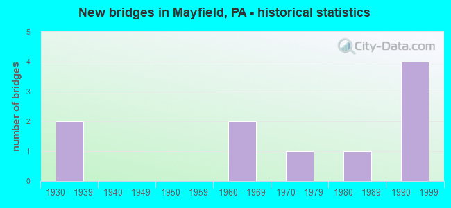
- New bridges - historical statistics
- 21930-1939
- 21960-1969
- 11970-1979
- 11980-1989
- 41990-1999

- Reconstructed bridges - Historical Statistics
- 12000-2009
- 22010-2019


- Bridge Condition - Deck
- 28.6%Very good
- 57.1%Good
- 14.3%Fair

- Bridge Condition - Superstructure
- 14.3%Excellent
- 28.6%Very good
- 14.3%Good
- 42.9%Fair

- Bridge Condition - Substructure
- 14.3%Very good
- 14.3%Good
- 28.6%Satisfactory
- 42.9%Fair

- Bridge Condition - Channel
- 33.3%Very good
- 16.7%Good
- 16.7%Fair
- 33.3%Poor
Find on map >> Show street view
Structure Number: 3967, Location: 0.2 MILE EAST OF US 220 (Lat: 40.021831, Lng: -78.507989), Route carried "on" structure: US 30, Year Built: 1970, Year Reconstructed: 2007, Status: Open, Structure Length: 20.73m (68.01ft), Average Daily Traffic: 13,085 (year 2020), Truck Traffic: 18%, Average Future Daily Traffic: 18,076 (year 2032), Design Load: H 20, Features Intersected: RAYSTOWN BR JUNIATA RIV
Minimum Vertical Clearance: 30+ m (98+ ft), Kilometerpoint: 25.088, Lanes on structure: 2, Base Highway Network: Yes, Owner: State Highway Agency, Approaching Roadway Width: 9.1m (29.9ft), Skew: 30 degrees, Material/Design: Prestressed concrete, Design/Construction: Stringer/Multi-beam, Number Of Spans In Main Unit: 6, Length of Maximum Span: 32.9m (107.9ft), Curb or Sidewalk Widths: Left: 0.2m (0.7ft), Right: 0.2m (0.7ft), Curb-To-Curb Width: 8.8m (28.9ft), Out-to-Out Width: 20.0m (65.6ft)
Condition: Deck: Good, Superstructure: Fair, Substructure: Fair, Channel: Fair, Operating Rating: 65.3 metric tons, Method Used To Determine Operating Rating: Load Factor (LF), Inventory Rating: 20.9 metric tons, Method Used To Determine Inventory Rating: Load Factor (LF), Structural Evaluation: Somewhat better than minimum adequacy, Deck Geometry: Meets minimum limits, Waterway Adequacy: Superior to present desirable criteria, Approach Roadway Alignment: Equal to present desirable criteria, Length Of Structure Improvement: 26.70m (87.60ft), Designated Inspection Frequency: Every 24 months, Inspection Date: June 2020, Bridge Improvement Cost: $962,000, Roadway Improvement Cost: $2,834,000, Total Project Cost: $12,990,000, Deck Structure Type: Concrete Cast-file-Place, Wearing Surface/Protective System: Wearing Surface: Latex Concrete
Find on map >> Show street view
Structure Number: 20396, Location: MAYFIELD BORO OVER TR 107 (Lat: 41.534944, Lng: -75.551197), Route carried "on" structure: US 6B, Year Built: 1938, Year Reconstructed: 2016, Status: Open, Structure Length: 3.29m (10.79ft), Average Daily Traffic: 8,891 (year 2022), Truck Traffic: 3%, Average Future Daily Traffic: 12,953 (year 2032), Design Load: H 20, Features Intersected: RUSH BROOK PA 107, Facility Carried by Structure: SR 6006 BUSINESS 6
Minimum Vertical Clearance: 30+ m (98+ ft), Kilometerpoint: 13.316, Lanes on structure: 2, Lanes under structure: 2, Base Highway Network: Yes, Owner: State Highway Agency, Approaching Roadway Width: 9.4m (30.8ft), Material/Design: Steel, Design/Construction: Truss - Thru, Number Of Spans In Main Unit: 1, Length of Maximum Span: 31.7m (104.0ft), Curb-To-Curb Width: 9.8m (32.2ft), Out-to-Out Width: 10.7m (35.1ft)
Condition: Deck: Good, Superstructure: Fair, Substructure: Satisfactory, Channel: Good, Operating Rating: 59.0 metric tons, Method Used To Determine Operating Rating: Load Factor (LF), Inventory Rating: 35.4 metric tons, Method Used To Determine Inventory Rating: Load Factor (LF), Structural Evaluation: Somewhat better than minimum adequacy, Deck Geometry: Meets minimum limits, Underclear: Meets minimum limits, Waterway Adequacy: Superior to present desirable criteria, Approach Roadway Alignment: Equal to present desirable criteria, Length Of Structure Improvement: 3.10m (10.17ft), Designated Inspection Frequency: Every 24 months, Critical Feature Inspection Frequency: Every 24 months, Other Special Inspection Frequency: Every 6 months, Inspection Date: July 2020, Critical Feature Inspection Date: July 2020, Other Special Inspection Date: July 2021, Bridge Improvement Cost: $16,000, Roadway Improvement Cost: $100,000, Total Project Cost: $211,000, Deck Structure Type: Concrete Cast-file-Place, Wearing Surface/Protective System: Wearing Surface: Monolithic Concrete, Deck Protection: Epoxy Coated Reinforcing
Find on map >> Show street view
Structure Number: 2054, Location: MAYFIELD BORO 150' W TR 6 (Lat: 41.535317, Lng: -75.551828), Route carried "on" structure: State highway 107, Year Built: 1988, Status: Open, Structure Length: 1.13m (3.71ft), Average Daily Traffic: 5,421 (year 2022), Truck Traffic: 6%, Average Future Daily Traffic: 8,740 (year 2032), Design Load: HS 25 or greater, Features Intersected: RUSHBROOK CREEK
Minimum Vertical Clearance: 30+ m (98+ ft), Kilometerpoint: 20.596, Lanes on structure: 2, Base Highway Network: Yes, Owner: State Highway Agency, Approaching Roadway Width: 8.2m (26.9ft), Skew: 4 degrees, Material/Design: Prestressed concrete, Design/Construction: Box Beam or Girders - Multiple, Number Of Spans In Main Unit: 1, Length of Maximum Span: 10.4m (34.1ft), Curb or Sidewalk Widths: Left: 0.2m (0.7ft), Right: 0.2m (0.7ft), Curb-To-Curb Width: 10.3m (33.8ft), Out-to-Out Width: 11.1m (36.4ft)
Condition: Deck: Good, Superstructure: Very good, Substructure: Fair, Channel: Poor, Operating Rating: 87.1 metric tons, Method Used To Determine Operating Rating: Load Factor (LF), Inventory Rating: 53.5 metric tons, Method Used To Determine Inventory Rating: Load Factor (LF), Structural Evaluation: Somewhat better than minimum adequacy, Deck Geometry: Meets minimum limits, Waterway Adequacy: Equal to present minimum criteria, Approach Roadway Alignment: Equal to present desirable criteria, Length Of Structure Improvement: 1.70m (5.58ft), Designated Inspection Frequency: Every 24 months, Inspection Date: May 2020, Deck Structure Type: Concrete Cast-file-Place, Wearing Surface/Protective System: Wearing Surface: Monolithic Concrete, Deck Protection: Epoxy Coated Reinforcing
Find on map >> Show street view
Structure Number: 20673, Location: MAYFIELD BO 353'E SR 1023 (Lat: 41.542139, Lng: -75.536314), Route carried "on" structure: State highway , Year Built: 1963, Year Reconstructed: 2010, Status: Open, Structure Length: 2.32m (7.61ft), Average Daily Traffic: 739 (year 2022), Truck Traffic: 9%, Average Future Daily Traffic: 969 (year 2032), Design Load: HS 20, Features Intersected: LACKAWANNA RIVER, Facility Carried by Structure: SR1008 CHESTNUT ST
Minimum Vertical Clearance: 30+ m (98+ ft), Kilometerpoint: 0.000, Lanes on structure: 2, Owner: State Highway Agency, Approaching Roadway Width: 12.2m (40.0ft), Material/Design: Prestressed concrete, Design/Construction: Box Beam or Girders - Multiple, Number Of Spans In Main Unit: 1, Length of Maximum Span: 22.9m (75.1ft), Curb or Sidewalk Widths: Left: 1.5m (4.9ft), Right: 1.5m (4.9ft), Curb-To-Curb Width: 12.2m (40.0ft), Out-to-Out Width: 16.2m (53.1ft)
Condition: Deck: Very good, Superstructure: Very good, Substructure: Fair, Channel: Poor, Inventory Rating: 37.2 metric tons, Method Used To Determine Inventory Rating: Load Factor (LF), Structural Evaluation: Somewhat better than minimum adequacy, Deck Geometry: Equal to present desirable criteria, Waterway Adequacy: Equal to present minimum criteria, Approach Roadway Alignment: Equal to present desirable criteria, Length Of Structure Improvement: 2.30m (7.55ft), Designated Inspection Frequency: Every 24 months, Underwater Inspection Frequency: Every 24 months, Inspection Date: May 2020, Underwater Inspection Date: June 2020, Bridge Improvement Cost: $34,000, Roadway Improvement Cost: $100,000, Total Project Cost: $459,000, Wearing Surface/Protective System: Wearing Surface: Epoxy Overlay, Deck Protection: Epoxy Coated Reinforcing
Find on map >> Show street view
Structure Number: 20704, Location: CARBNDLE TP .1M S SR6 BUS (Lat: 41.551736, Lng: -75.527222), Route carried "on" structure: State highway , Year Built: 1995, Status: Open, Structure Length: 3.84m (12.60ft), Average Daily Traffic: 7,266 (year 2022), Truck Traffic: 7%, Average Future Daily Traffic: 9,833 (year 2032), Design Load: HS 25 or greater, Features Intersected: LACKAWANNA RIVER, Facility Carried by Structure: SR 1039
Minimum Vertical Clearance: 30+ m (98+ ft), Kilometerpoint: 0.999, Lanes on structure: 3, Owner: State Highway Agency, Approaching Roadway Width: 17.1m (56.1ft), Skew: 1 degrees, Material/Design: Prestressed concrete, Design/Construction: Stringer/Multi-beam, Number Of Spans In Main Unit: 1, Length of Maximum Span: 36.6m (120.1ft), Curb or Sidewalk Widths: Left: 0.2m (0.7ft), Right: 0.2m (0.7ft), Curb-To-Curb Width: 17.1m (56.1ft), Out-to-Out Width: 18.1m (59.4ft)
Condition: Deck: Very good, Superstructure: Excellent, Substructure: Very good, Channel: Very good, Inventory Rating: 50.8 metric tons, Method Used To Determine Inventory Rating: Load Factor (LF), Structural Evaluation: Equal to present desirable criteria, Deck Geometry: Superior to present desirable criteria, Waterway Adequacy: Superior to present desirable criteria, Approach Roadway Alignment: Equal to present desirable criteria, Length Of Structure Improvement: 4.60m (15.09ft), Designated Inspection Frequency: Every 24 months, Inspection Date: May 2020, Deck Structure Type: Concrete Cast-file-Place, Wearing Surface/Protective System: Wearing Surface: Monolithic Concrete, Deck Protection: Epoxy Coated Reinforcing
Find on map >> Show street view
Structure Number: 20936, Location: 100' SE OF WASHINGTON AVE (Lat: 41.537858, Lng: -75.541094), Route carried "on" structure: City street , Year Built: 1964, Status: Open, Structure Length: 1.92m (6.30ft), Average Daily Traffic: 4,216 (year 2018), Truck Traffic: 5%, Average Future Daily Traffic: 5,144 (year 2036), Design Load: HS 20, Features Intersected: LACKAWANNA RIVER, Facility Carried by Structure: POPLAR STREET
Minimum Vertical Clearance: 30+ m (98+ ft), Kilometerpoint: 0.000, Lanes on structure: 2, Owner: County Highway Agency, Approaching Roadway Width: 12.5m (41.0ft), Material/Design: Prestressed concrete, Design/Construction: Box Beam or Girders - Multiple, Number Of Spans In Main Unit: 1, Length of Maximum Span: 18.3m (60.0ft), Curb or Sidewalk Widths: Left: 1.5m (4.9ft), Right: 1.5m (4.9ft), Curb-To-Curb Width: 9.2m (30.2ft), Out-to-Out Width: 13.0m (42.7ft)
Condition: Deck: Fair, Superstructure: Fair, Substructure: Satisfactory, Channel: Very good, Operating Rating: 60.8 metric tons, Method Used To Determine Operating Rating: Load Factor (LF), Inventory Rating: 17.2 metric tons, Method Used To Determine Inventory Rating: Load Factor (LF), Structural Evaluation: Meets minimum limits, Deck Geometry: Meets minimum limits, Waterway Adequacy: Equal to present desirable criteria, Approach Roadway Alignment: Somewhat better than minimum adequacy, Length Of Structure Improvement: 1.90m (6.23ft), Designated Inspection Frequency: Every 24 months, Inspection Date: April 2020, Bridge Improvement Cost: $11,000, Roadway Improvement Cost: $31,000, Total Project Cost: $144,000, Deck Structure Type: Concrete Cast-file-Place, Wearing Surface/Protective System: Wearing Surface: Bituminous
Find on map >> Show street view
Structure Number: 3967, Location: MAYFIELD BORO OVER TR 6 (Lat: 41.530556, Lng: -75.522778), Route carried "on" structure: State highway 107, Year Built: 1995, Status: Open, Structure Length: 7.13m (23.39ft), Average Daily Traffic: 4,337 (year 2022), Truck Traffic: 7%, Average Future Daily Traffic: 4,955 (year 2032), Design Load: HS 25 or greater, Features Intersected: SR 0006 EB & WB
Minimum Vertical Clearance: 30+ m (98+ ft), Kilometerpoint: 22.796, Lanes on structure: 2, Lanes under structure: 4, Base Highway Network: Yes, Owner: State Highway Agency, Approaching Roadway Width: 14.0m (45.9ft), Material/Design: Steel continuous, Design/Construction: Stringer/Multi-beam, Number Of Spans In Main Unit: 2, Length of Maximum Span: 39.6m (129.9ft), Curb or Sidewalk Widths: Left: 0.2m (0.7ft), Right: 0.2m (0.7ft), Curb-To-Curb Width: 13.4m (44.0ft), Out-to-Out Width: 14.5m (47.6ft)
Condition: Deck: Good, Superstructure: Good, Substructure: Good, Operating Rating: 74.4 metric tons, Method Used To Determine Operating Rating: Load Factor (LF), Inventory Rating: 44.5 metric tons, Method Used To Determine Inventory Rating: Load Factor (LF), Structural Evaluation: Better than present minimum criteria, Deck Geometry: Better than present minimum criteria, Underclear: Better than present minimum criteria, Approach Roadway Alignment: Equal to present desirable criteria, Length Of Structure Improvement: 8.00m (26.25ft), Designated Inspection Frequency: Every 24 months, Inspection Date: June 2020, Deck Structure Type: Concrete Cast-file-Place, Wearing Surface/Protective System: Wearing Surface: Monolithic Concrete, Deck Protection: Epoxy Coated Reinforcing
Find on map >> Show street view
Structure Number: 20396, Location: MAYFIELD BORO OVER TR 107 (Lat: 41.534944, Lng: -75.551197), Route carried "under" structure: State highway 107, Year Built: 1938, Structure Length: 0. m, Average Daily Traffic: 5,421 (year 2022), Truck Traffic: 6%, Features Intersected: RUSH BROOK PA 107, Facility Carried by Structure: SR 6006 BUSINESS 6
Minimum Vertical Clearance: 4.33m (14.21ft), Kilometerpoint: 21.462, Lanes on structure: 2, Lanes under structure: 2, Material/Design: Steel, Design/Construction: Truss - Thru, Length of Maximum Span: 31.7m (104.0ft)
Find on map >> Show street view
Structure Number: 3967, Location: MAYFIELD BORO OVER TR 6 (Lat: 41.530556, Lng: -75.522778), Route carried "under" structure: US 6, Year Built: 1995, Structure Length: 0. m, Average Daily Traffic: 7,538 (year 2022), Truck Traffic: 6%, Features Intersected: SR 0006 EB & WB, Facility Carried by Structure: TR107 RUSHBROOK ST
Minimum Vertical Clearance: 7.35m (24.11ft), Kilometerpoint: 29.633, Lanes on structure: 2, Lanes under structure: 2, Material/Design: Steel continuous, Design/Construction: Stringer/Multi-beam, Length of Maximum Span: 39.6m (129.9ft)
Find on map >> Show street view
Structure Number: 3967, Location: MAYFIELD BORO OVER TR 6 (Lat: 41.530556, Lng: -75.522778), Route carried "under" structure: US 6, Year Built: 1995, Structure Length: 0. m, Average Daily Traffic: 7,615 (year 2022), Truck Traffic: 7%, Features Intersected: SR 0006 EB & WB, Facility Carried by Structure: TR107 RUSHBROOK ST
Minimum Vertical Clearance: 5.39m (17.68ft), Kilometerpoint: 29.766, Lanes on structure: 2, Lanes under structure: 2, Material/Design: Steel continuous, Design/Construction: Stringer/Multi-beam, Length of Maximum Span: 39.6m (129.9ft)