Bridge Statistics for Maxwell, Nebraska (NE)
Condition, Traffic, Stress, Structural Evaluation, Project Costs
- National Bridge Inventory (NBI) Statistics
- 10Number of bridges
- 210ft / 63.9mTotal length
- 34,980Total average daily traffic
- 13,701Total average daily truck traffic
- National Bridge Inventory (NBI) Registered Bridges for Maxwell
- No street view available for this location
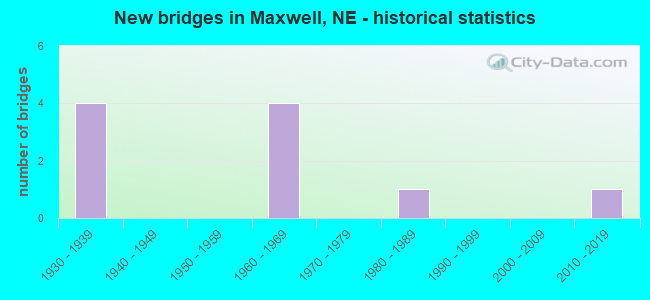
- New bridges - historical statistics
- 41930-1939
- 41960-1969
- 11980-1989
- 12010-2019

- Reconstructed bridges - Historical Statistics
- 31980-1989
- 01990-1999
- 12000-2009


- Bridge Condition - Deck
- 57.1%Good
- 14.3%Satisfactory
- 28.6%Fair

- Bridge Condition - Superstructure
- 14.3%Very good
- 14.3%Good
- 28.6%Satisfactory
- 28.6%Fair
- 14.3%Serious

- Bridge Condition - Substructure
- 14.3%Very good
- 14.3%Good
- 14.3%Satisfactory
- 28.6%Fair
- 14.3%Poor
- 14.3%Serious

- Bridge Condition - Channel
- 60.0%Good
- 20.0%Satisfactory
- 20.0%Serious
Find on map >> Show street view
Structure Number: C005637305P, Location: 10.7W 1.2N OF BRADY (Lat: 41.036000, Lng: -100.574000), Route carried "on" structure: County highway P373, Year Built: 1935, Status: Posted for load, Structure Length: 3.26m (10.70ft), Average Daily Traffic: 50 (year 2003), Truck Traffic: 20%, Average Future Daily Traffic: 85 (year 2033), Features Intersected: TRI-COUNTY CANAL MP 9.0, Facility Carried by Structure: COUNTY HIGHWAY
Minimum Vertical Clearance: 30+ m (98+ ft), Kilometerpoint: 0.000, Lanes on structure: 2, Owner: Local Agency, Approaching Roadway Width: 6.4m (21.0ft), Material/Design: Wood or Timber, Design/Construction: Stringer/Multi-beam, Number Of Spans In Main Unit: 4, Length of Maximum Span: 8.2m (26.9ft), Curb-To-Curb Width: 6.6m (21.7ft), Out-to-Out Width: 6.7m (22.0ft)
Condition: Deck: Good, Superstructure: Fair, Substructure: Poor, Channel: Good, Operating Rating: 9.0 metric tons, Method Used To Determine Operating Rating: Allowable Stress (AS), Inventory Rating: 5.0 metric tons, Method Used To Determine Inventory Rating: Allowable Stress (AS), Structural Evaluation: High priority of replacement, Deck Geometry: Somewhat better than minimum adequacy, Waterway Adequacy: Superior to present desirable criteria, Approach Roadway Alignment: Equal to present minimum criteria, Bridge Posting: Required (Relationship of Operating Rating to Maximum Legal Load: > 39.9% below), Length Of Structure Improvement: 3.26m (10.70ft), Designated Inspection Frequency: Every 24 months, Underwater Inspection Frequency: Every 60 months, Inspection Date: October 2020, Underwater Inspection Date: August 2018, Deck Structure Type: Wood or Timber, Wearing Surface/Protective System: Wearing Surface: Wood or Timber
Find on map >> Show street view
Structure Number: C005644810P, Location: 1.4S 1.4E OF MAXWELL (Lat: 41.056900, Lng: -100.498400), Route carried "on" structure: County highway P448, Year Built: 2014, Status: Open, Structure Length: 0.61m (2.00ft), Average Daily Traffic: 20 (year 2003), Average Future Daily Traffic: 34 (year 2033), Design Load: HL 93, Features Intersected: PLATTE RIVER OVERFLOW, Facility Carried by Structure: GUN CLUB RD
Minimum Vertical Clearance: 30+ m (98+ ft), Kilometerpoint: 0.000, Lanes on structure: 2, Owner: County Highway Agency, Approaching Roadway Width: 8.8m (28.9ft), Material/Design: Steel, Design/Construction: Culvert, Number Of Spans In Main Unit: 2, Length of Maximum Span: 2.4m (7.9ft)
Condition: Channel: Serious, Culverts: Excellent, Operating Rating: 42.0 metric tons, Method Used To Determine Operating Rating: Load Factor (LF), Inventory Rating: 33.0 metric tons, Method Used To Determine Inventory Rating: Load Factor (LF), Structural Evaluation: Superior to present desirable criteria, Waterway Adequacy: Somewhat better than minimum adequacy, Approach Roadway Alignment: Meets minimum limits, Length Of Structure Improvement: 1.71m (5.61ft), Designated Inspection Frequency: Every 24 months, Inspection Date: November 2020
Find on map >> Show street view
Structure Number: S030 1903, Location: 0W MAXWELL (Lat: 41.083900, Lng: -100.542900), Route carried "on" structure: US 30, Year Built: 1985, Status: Open, Structure Length: 13.44m (44.09ft), Average Daily Traffic: 2,050 (year 2018), Truck Traffic: 9%, Average Future Daily Traffic: 2,768 (year 2038), Features Intersected: UPRR 817-958-J
Minimum Vertical Clearance: 30+ m (98+ ft), Kilometerpoint: 30.626, Lanes on structure: 2, Base Highway Network: Yes, Owner: State Highway Agency, Approaching Roadway Width: 12.2m (40.0ft), Skew: 6 degrees, Material/Design: Steel continuous, Design/Construction: Stringer/Multi-beam, Number Of Spans In Main Unit: 5, Length of Maximum Span: 32.9m (107.9ft), Curb or Sidewalk Widths: Left: 0.2m (0.7ft), Right: 0.2m (0.7ft), Curb-To-Curb Width: 12.2m (40.0ft), Out-to-Out Width: 13.0m (42.7ft)
Condition: Deck: Good, Superstructure: Very good, Substructure: Very good, Operating Rating: 54.0 metric tons, Method Used To Determine Operating Rating: Load Factor (LF), Inventory Rating: 32.0 metric tons, Method Used To Determine Inventory Rating: Load Factor (LF), Structural Evaluation: Better than present minimum criteria, Deck Geometry: Equal to present minimum criteria, Underclear: Better than present minimum criteria, Approach Roadway Alignment: Equal to present desirable criteria, Designated Inspection Frequency: Every 24 months, Inspection Date: November 2021, Deck Structure Type: Concrete Cast-file-Place, Wearing Surface/Protective System: Wearing Surface: Bituminous, Membrane: Preformed Fabric, Deck Protection: Epoxy Coated Reinforcing
Find on map >> Show street view
Structure Number: S080 19045, Location: MAXWELL INTERCHG (Lat: 41.051400, Lng: -100.525500), Route carried "on" structure: Spur State highway S56A, Year Built: 1965, Year Reconstructed: 2009, Status: Open, Structure Length: 7.28m (23.88ft), Average Daily Traffic: 850 (year 2018), Truck Traffic: 9%, Average Future Daily Traffic: 1,105 (year 2038), Features Intersected: I80
Minimum Vertical Clearance: 30+ m (98+ ft), Kilometerpoint: 0.309, Lanes on structure: 2, Lanes under structure: 4, Owner: State Highway Agency, Approaching Roadway Width: 12.2m (40.0ft), Material/Design: Prestressed concrete, Design/Construction: Stringer/Multi-beam, Number Of Spans In Main Unit: 4, Length of Maximum Span: 21.6m (70.9ft), Curb or Sidewalk Widths: Left: 0.5m (1.6ft), Right: 0.5m (1.6ft), Curb-To-Curb Width: 8.5m (27.9ft), Out-to-Out Width: 10.1m (33.1ft)
Condition: Deck: Good, Superstructure: Satisfactory, Substructure: Satisfactory, Operating Rating: 41.0 metric tons, Method Used To Determine Operating Rating: Load Factor (LF), Inventory Rating: 24.0 metric tons, Method Used To Determine Inventory Rating: Load Factor (LF), Structural Evaluation: Equal to present minimum criteria, Deck Geometry: Somewhat better than minimum adequacy, Underclear: Equal to present minimum criteria, Approach Roadway Alignment: Equal to present desirable criteria, Designated Inspection Frequency: Every 24 months, Inspection Date: December 2021, Deck Structure Type: Concrete Cast-file-Place, Wearing Surface/Protective System: Wearing Surface: Integral Concrete
Find on map >> Show street view
Structure Number: S080 19243, Location: 2E MAXWELL INTRCHG (Lat: 41.042300, Lng: -100.490000), Route carried "on" structure: County highway 181, Year Built: 1965, Status: Open, Structure Length: 7.19m (23.59ft), Average Daily Traffic: 35 (year 2003), Average Future Daily Traffic: 50 (year 2033), Features Intersected: I80, Facility Carried by Structure: COUNTY HIGHWAY
Minimum Vertical Clearance: 30+ m (98+ ft), Kilometerpoint: 0.000, Lanes on structure: 2, Lanes under structure: 4, Owner: State Highway Agency, Approaching Roadway Width: 7.3m (24.0ft), Material/Design: Prestressed concrete, Design/Construction: Stringer/Multi-beam, Number Of Spans In Main Unit: 4, Length of Maximum Span: 21.3m (69.9ft), Curb or Sidewalk Widths: Left: 0.3m (1.0ft), Right: 0.3m (1.0ft), Curb-To-Curb Width: 6.1m (20.0ft), Out-to-Out Width: 7.7m (25.3ft)
Condition: Deck: Good, Superstructure: Good, Substructure: Good, Operating Rating: 39.0 metric tons, Method Used To Determine Operating Rating: Load Factor (LF), Inventory Rating: 24.0 metric tons, Method Used To Determine Inventory Rating: Load Factor (LF), Structural Evaluation: Equal to present minimum criteria, Deck Geometry: Somewhat better than minimum adequacy, Underclear: Equal to present minimum criteria, Approach Roadway Alignment: Equal to present desirable criteria, Designated Inspection Frequency: Every 24 months, Inspection Date: December 2021, Deck Structure Type: Concrete Cast-file-Place, Wearing Surface/Protective System: Wearing Surface: Monolithic Concrete
Find on map >> Show street view
Structure Number: SS56A00115, Location: 1S MAXWELL (Lat: 41.062700, Lng: -100.525000), Route carried "on" structure: Spur State highway S56A, Year Built: 1931, Year Reconstructed: 1980, Status: Open, Structure Length: 18.35m (60.20ft), Average Daily Traffic: 955 (year 2018), Truck Traffic: 9%, Average Future Daily Traffic: 1,242 (year 2038), Design Load: H 15, Features Intersected: N CH PLATTE RIVER
Minimum Vertical Clearance: 30+ m (98+ ft), Kilometerpoint: 0.185, Lanes on structure: 2, Base Highway Network: Yes, Owner: State Highway Agency, Approaching Roadway Width: 11.0m (36.1ft), Material/Design: Steel, Design/Construction: Stringer/Multi-beam, Number Of Spans In Main Unit: 12, Number Of Approach Spans: 2, Length of Maximum Span: 15.2m (49.9ft), Curb-To-Curb Width: 11.0m (36.1ft), Out-to-Out Width: 11.7m (38.4ft)
Condition: Deck: Fair, Superstructure: Fair, Substructure: Fair, Channel: Good, Operating Rating: 34.0 metric tons, Method Used To Determine Operating Rating: Load Factor (LF), Inventory Rating: 20.0 metric tons, Method Used To Determine Inventory Rating: Load Factor (LF), Structural Evaluation: Somewhat better than minimum adequacy, Deck Geometry: Better than present minimum criteria, Waterway Adequacy: Equal to present desirable criteria, Approach Roadway Alignment: Equal to present desirable criteria, Bridge Posting: Required (Relationship of Operating Rating to Maximum Legal Load: 0.1 - 9.9% below), Designated Inspection Frequency: Every 24 months, Inspection Date: December 2021, Deck Structure Type: Concrete Cast-file-Place, Wearing Surface/Protective System: Wearing Surface: Low Slump Concrete
Find on map >> Show street view
Structure Number: SS56A00269, Location: 2S MAXWELL (Lat: 41.040700, Lng: -100.525500), Route carried "on" structure: Spur State highway S56A, Year Built: 1931, Year Reconstructed: 1980, Status: Open, Structure Length: 6.13m (20.11ft), Average Daily Traffic: 850 (year 2018), Truck Traffic: 9%, Average Future Daily Traffic: 1,105 (year 2038), Design Load: H 15, Features Intersected: PLATTE RIVER MID CHAN
Minimum Vertical Clearance: 30+ m (98+ ft), Kilometerpoint: 0.430, Lanes on structure: 2, Owner: State Highway Agency, Approaching Roadway Width: 7.3m (24.0ft), Material/Design: Steel, Design/Construction: Stringer/Multi-beam, Number Of Spans In Main Unit: 4, Length of Maximum Span: 15.2m (49.9ft), Curb-To-Curb Width: 9.8m (32.2ft), Out-to-Out Width: 10.5m (34.4ft)
Condition: Deck: Satisfactory, Superstructure: Satisfactory, Substructure: Fair, Channel: Good, Operating Rating: 44.0 metric tons, Method Used To Determine Operating Rating: Load Factor (LF), Inventory Rating: 26.0 metric tons, Method Used To Determine Inventory Rating: Load Factor (LF), Structural Evaluation: Somewhat better than minimum adequacy, Deck Geometry: Equal to present minimum criteria, Waterway Adequacy: Equal to present desirable criteria, Approach Roadway Alignment: Equal to present desirable criteria, Length Of Structure Improvement: 6.13m (20.11ft), Designated Inspection Frequency: Every 24 months, Inspection Date: December 2021, Deck Structure Type: Concrete Cast-file-Place, Wearing Surface/Protective System: Wearing Surface: Low Slump Concrete
Find on map >> Show street view
Structure Number: SS56A00305, Location: 3S MAXWELL (Lat: 41.036600, Lng: -100.525500), Route carried "on" structure: Spur State highway S56A, Year Built: 1931, Year Reconstructed: 1980, Status: Posted for load, Structure Length: 7.65m (25.10ft), Average Daily Traffic: 850 (year 2018), Truck Traffic: 9%, Average Future Daily Traffic: 1,105 (year 2038), Features Intersected: PLATTE RIVER S CHAN
Minimum Vertical Clearance: 30+ m (98+ ft), Kilometerpoint: 0.475, Lanes on structure: 2, Owner: State Highway Agency, Approaching Roadway Width: 7.3m (24.0ft), Material/Design: Steel, Design/Construction: Stringer/Multi-beam, Number Of Spans In Main Unit: 5, Length of Maximum Span: 15.2m (49.9ft), Curb-To-Curb Width: 9.8m (32.2ft), Out-to-Out Width: 10.5m (34.4ft)
Condition: Deck: Fair, Superstructure: Serious, Substructure: Serious, Channel: Satisfactory, Operating Rating: 28.0 metric tons, Method Used To Determine Operating Rating: Load Factor (LF), Inventory Rating: 16.0 metric tons, Method Used To Determine Inventory Rating: Load Factor (LF), Structural Evaluation: High priority of corrective action, Deck Geometry: Equal to present minimum criteria, Waterway Adequacy: Equal to present desirable criteria, Approach Roadway Alignment: Equal to present desirable criteria, Bridge Posting: Required (Relationship of Operating Rating to Maximum Legal Load: 20.0 - 29.9% below), Length Of Structure Improvement: 7.65m (25.10ft), Designated Inspection Frequency: Every 24 months, Other Special Inspection Frequency: Every 24 months, Inspection Date: December 2021, Other Special Inspection Date: March 2021, Deck Structure Type: Concrete Cast-file-Place, Wearing Surface/Protective System: Wearing Surface: Low Slump Concrete
Find on map >> Show street view
Structure Number: S080 19045, Location: MAXWELL INTERCHG (Lat: 41.051400, Lng: -100.525500), Route carried "under" structure: Interstate 80, Year Built: 1965, Structure Length: 0. m, Average Daily Traffic: 14,660 (year 2013), Truck Traffic: 45%, Features Intersected: I80, Facility Carried by Structure: S56A
Minimum Vertical Clearance: 5.08m (16.67ft), Kilometerpoint: 30.650, Lanes on structure: 4, Lanes under structure: 4, Material/Design: Prestressed concrete, Design/Construction: Stringer/Multi-beam, Length of Maximum Span: 21.6m (70.9ft)
Find on map >> Show street view
Structure Number: S080 19243, Location: 2E MAXWELL INTRCHG (Lat: 41.042300, Lng: -100.490000), Route carried "under" structure: Interstate 80, Year Built: 1965, Structure Length: 0. m, Average Daily Traffic: 14,660 (year 2013), Truck Traffic: 45%, Features Intersected: I80, Facility Carried by Structure: COUNTY HIGHWAY
Minimum Vertical Clearance: 5.10m (16.73ft), Kilometerpoint: 30.969, Lanes on structure: 4, Lanes under structure: 4, Material/Design: Prestressed concrete, Design/Construction: Stringer/Multi-beam, Length of Maximum Span: 21.3m (69.9ft)