Bridge Statistics for Maxton, North Carolina (NC)
Condition, Traffic, Stress, Structural Evaluation, Project Costs
- National Bridge Inventory (NBI) Statistics
- 39Number of bridges
- 476ft / 145mTotal length
- 203,520Total average daily traffic
- 22,276Total average daily truck traffic
- National Bridge Inventory (NBI) Registered Bridges for Maxton
- No street view available for this location
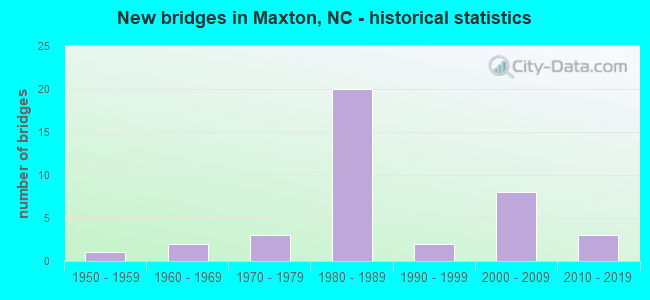
- New bridges - historical statistics
- 11950-1959
- 21960-1969
- 31970-1979
- 201980-1989
- 21990-1999
- 82000-2009
- 32010-2019


- Bridge Condition - Deck
- 29.2%Very good
- 33.3%Good
- 25.0%Satisfactory
- 8.3%Fair
- 4.2%Critical

- Bridge Condition - Superstructure
- 33.3%Very good
- 41.7%Good
- 12.5%Satisfactory
- 8.3%Fair
- 4.2%Critical

- Bridge Condition - Substructure
- 62.5%Good
- 29.2%Satisfactory
- 8.3%Fair

- Bridge Condition - Channel
- 11.8%Very good
- 64.7%Good
- 17.6%Satisfactory
- 5.9%Fair

- Bridge Condition - Culverts
- 33.3%Very good
- 66.7%Good
Find on map >> Show street view
Structure Number: 150006, Location: 2 MI. E. JCT. SR1204 (Lat: 36.178025, Lng: -77.180711), Route carried "on" structure: State highway 1203, Year Built: 1995, Status: Open, Structure Length: 1.49m (4.89ft), Average Daily Traffic: 240 (year 2015), Truck Traffic: 6%, Average Future Daily Traffic: 480 (year 2040), Design Load: HS 20+Mod, Features Intersected: SWAMP
Minimum Vertical Clearance: 30+ m (98+ ft), Kilometerpoint: 0.000, Lanes on structure: 2, Owner: State Highway Agency, Approaching Roadway Width: 5.4m (17.7ft), Material/Design: Steel, Design/Construction: Culvert, Number Of Spans In Main Unit: 4, Length of Maximum Span: 3.0m (9.8ft)
Condition: Channel: Satisfactory, Culverts: Good, Operating Rating: 89.8 metric tons, Method Used To Determine Operating Rating: Load and Resistance Factor (LRFR), Inventory Rating: 73.4 metric tons, Method Used To Determine Inventory Rating: Load and Resistance Factor (LRFR), Structural Evaluation: Better than present minimum criteria, Waterway Adequacy: Better than present minimum criteria, Approach Roadway Alignment: Equal to present minimum criteria, Designated Inspection Frequency: Every 24 months, Underwater Inspection Frequency: Every 60 months, Inspection Date: June 2020, Underwater Inspection Date: June 2020
Find on map >> Show street view
Structure Number: 150008, Location: 0.1 MI.S.JCT.SR1126 (Lat: 36.016608, Lng: -77.212117), Route carried "on" structure: State highway 11, Year Built: 1966, Status: Open, Structure Length: 5.39m (17.68ft), Average Daily Traffic: 5,400 (year 2018), Truck Traffic: 8%, Average Future Daily Traffic: 10,800 (year 2040), Design Load: HS 20+Mod, Features Intersected: ROANOKE RIVER OVER
Minimum Vertical Clearance: 30+ m (98+ ft), Kilometerpoint: 0.000, Lanes on structure: 2, Base Highway Network: Yes (Inventory Route: 3, Subroute: 11), Owner: State Highway Agency, Approaching Roadway Width: 8.5m (27.9ft), Material/Design: Prestressed concrete, Design/Construction: Stringer/Multi-beam, Number Of Spans In Main Unit: 4, Length of Maximum Span: 12.8m (42.0ft), Curb or Sidewalk Widths: Left: 0.5m (1.6ft), Right: 0.5m (1.6ft), Curb-To-Curb Width: 8.5m (27.9ft), Out-to-Out Width: 10.3m (33.8ft)
Condition: Deck: Good, Superstructure: Satisfactory, Substructure: Satisfactory, Channel: Good, Operating Rating: 83.4 metric tons, Method Used To Determine Operating Rating: Load Factor (LF), Inventory Rating: 42.6 metric tons, Method Used To Determine Inventory Rating: Load Factor (LF), Structural Evaluation: Equal to present minimum criteria, Deck Geometry: High priority of replacement, Waterway Adequacy: Equal to present minimum criteria, Approach Roadway Alignment: Equal to present desirable criteria, Designated Inspection Frequency: Every 24 months, Inspection Date: July 2020, Deck Structure Type: Concrete Cast-file-Place, Wearing Surface/Protective System: Wearing Surface: Latex Concrete
Find on map >> Show street view
Structure Number: 150009, Location: 0.25 MI.N.JCT.SR1222 (Lat: 36.156711, Lng: -77.073192), Route carried "on" structure: State highway 1219, Year Built: 1970, Status: Closed, Structure Length: 1.82m (5.97ft), Average Daily Traffic: 300 (year 2015), Truck Traffic: 6%, Average Future Daily Traffic: 600 (year 2040), Design Load: H 10, Features Intersected: CONNARITSA SWAMP
Minimum Vertical Clearance: 30+ m (98+ ft), Kilometerpoint: 0.000, Lanes on structure: 2, Owner: State Highway Agency, Approaching Roadway Width: 5.4m (17.7ft), Material/Design: Prestressed concrete, Design/Construction: Channel Beam, Number Of Spans In Main Unit: 2, Length of Maximum Span: 9.1m (29.9ft), Curb or Sidewalk Widths: Left: 0.1m (0.3ft), Right: 0.1m (0.3ft), Curb-To-Curb Width: 8.8m (28.9ft), Out-to-Out Width: 9.2m (30.2ft)
Condition: Deck: Critical, Superstructure: Critical, Substructure: Satisfactory, Channel: Satisfactory, Operating Rating: 8.1 metric tons, Method Used To Determine Operating Rating: Load Factor (LF), Inventory Rating: 3.6 metric tons, Method Used To Determine Inventory Rating: Load Factor (LF), Deck Geometry: Equal to present minimum criteria, Approach Roadway Alignment: Equal to present desirable criteria, Bridge Posting: Required (Relationship of Operating Rating to Maximum Legal Load: > 39.9% below), Designated Inspection Frequency: Every 24 months, Inspection Date: June 2020, Deck Structure Type: Concrete Cast-file-Place, Wearing Surface/Protective System: Wearing Surface: Bituminous
Find on map >> Show street view
Structure Number: 150011, Location: 1.0 MI. E. JCT. NC308 (Lat: 36.124069, Lng: -77.121114), Route carried "on" structure: State highway 1219, Year Built: 2006, Status: Open, Structure Length: 4.87m (15.98ft), Average Daily Traffic: 340 (year 2017), Truck Traffic: 6%, Average Future Daily Traffic: 680 (year 2040), Design Load: HS 25 or greater, Features Intersected: CASHIE RIVER
Minimum Vertical Clearance: 30+ m (98+ ft), Kilometerpoint: 0.000, Lanes on structure: 2, Owner: State Highway Agency, Approaching Roadway Width: 10.0m (32.8ft), Material/Design: Prestressed concrete, Design/Construction: Slab, Number Of Spans In Main Unit: 4, Length of Maximum Span: 14.9m (48.9ft), Curb-To-Curb Width: 10.0m (32.8ft), Out-to-Out Width: 10.9m (35.8ft)
Condition: Deck: Very good, Superstructure: Very good, Substructure: Fair, Channel: Satisfactory, Operating Rating: 83.4 metric tons, Method Used To Determine Operating Rating: Load Factor (LF), Inventory Rating: 49.8 metric tons, Method Used To Determine Inventory Rating: Load Factor (LF), Structural Evaluation: Somewhat better than minimum adequacy, Deck Geometry: Better than present minimum criteria, Waterway Adequacy: Better than present minimum criteria, Approach Roadway Alignment: Equal to present desirable criteria, Designated Inspection Frequency: Every 24 months, Underwater Inspection Frequency: Every 60 months, Inspection Date: June 2020, Underwater Inspection Date: January 2021, Deck Structure Type: Concrete Precast Panels, Wearing Surface/Protective System: Wearing Surface: Bituminous
Find on map >> Show street view
Structure Number: 150012, Location: 3.0 MI S. OF JCT SR1521 (Lat: 35.875419, Lng: -77.029872), Route carried "on" structure: US 13, Year Built: 1968, Status: Open, Structure Length: 6.79m (22.28ft), Average Daily Traffic: 5,500 (year 2018), Truck Traffic: 14%, Average Future Daily Traffic: 11,000 (year 2040), Design Load: HS 20+Mod, Features Intersected: ROANOKE RIVER OVER
Minimum Vertical Clearance: 30+ m (98+ ft), Kilometerpoint: 0.000, Lanes on structure: 2, Base Highway Network: Yes (Inventory Route: 2, Subroute: 13), Owner: State Highway Agency, Approaching Roadway Width: 8.5m (27.9ft), Skew: 10 degrees, Material/Design: Concrete continuous, Design/Construction: Slab, Number Of Spans In Main Unit: 10, Length of Maximum Span: 6.4m (21.0ft), Curb-To-Curb Width: 10.3m (33.8ft), Out-to-Out Width: 11.1m (36.4ft)
Condition: Deck: Satisfactory, Superstructure: Satisfactory, Substructure: Satisfactory, Channel: Good, Operating Rating: 64.4 metric tons, Method Used To Determine Operating Rating: Load Factor (LF), Inventory Rating: 39.0 metric tons, Method Used To Determine Inventory Rating: Load Factor (LF), Structural Evaluation: Equal to present minimum criteria, Deck Geometry: Somewhat better than minimum adequacy, Waterway Adequacy: Superior to present desirable criteria, Approach Roadway Alignment: Equal to present desirable criteria, Designated Inspection Frequency: Every 24 months, Inspection Date: September 2020, Deck Structure Type: Concrete Cast-file-Place, Wearing Surface/Protective System: Wearing Surface: Monolithic Concrete
Find on map >> Show street view
Structure Number: 1550016, Location: 0.4 MI.W.JCT.ST1308 (Lat: 34.773028, Lng: -79.331644), Route carried "on" structure: State highway 71, Year Built: 2000, Status: Open, Structure Length: 6.18m (20.28ft), Average Daily Traffic: 8,900 (year 2019), Truck Traffic: 7%, Average Future Daily Traffic: 17,800 (year 2040), Design Load: HS 20+Mod, Features Intersected: LUMBER RIVER
Minimum Vertical Clearance: 30+ m (98+ ft), Kilometerpoint: 0.000, Lanes on structure: 2, Owner: State Highway Agency, Approaching Roadway Width: 9.7m (31.8ft), Skew: 3 degrees, Material/Design: Prestressed concrete, Design/Construction: Slab, Number Of Spans In Main Unit: 4, Length of Maximum Span: 14.9m (48.9ft), Curb-To-Curb Width: 10.1m (33.1ft), Out-to-Out Width: 11.0m (36.1ft)
Condition: Deck: Very good, Superstructure: Very good, Substructure: Good, Channel: Good, Operating Rating: 70.7 metric tons, Method Used To Determine Operating Rating: Load Factor (LF), Inventory Rating: 42.6 metric tons, Method Used To Determine Inventory Rating: Load Factor (LF), Structural Evaluation: Better than present minimum criteria, Deck Geometry: Meets minimum limits, Waterway Adequacy: Better than present minimum criteria, Approach Roadway Alignment: Equal to present desirable criteria, Designated Inspection Frequency: Every 24 months, Underwater Inspection Frequency: Every 60 months, Inspection Date: April 2021, Underwater Inspection Date: May 2021, Deck Structure Type: Concrete Precast Panels, Wearing Surface/Protective System: Wearing Surface: Bituminous
Find on map >> Show street view
Structure Number: 1550044, Location: 0.5 MI.S. OF JCT.NC130 (Lat: 34.683033, Lng: -79.376375), Route carried "on" structure: State highway 83, Year Built: 1977, Status: Open, Structure Length: 3.07m (10.07ft), Average Daily Traffic: 1,600 (year 2018), Truck Traffic: 7%, Average Future Daily Traffic: 3,200 (year 2040), Design Load: HS 15, Features Intersected: SHOE HEEL CREEK
Minimum Vertical Clearance: 30+ m (98+ ft), Kilometerpoint: 0.000, Lanes on structure: 2, Owner: State Highway Agency, Approaching Roadway Width: 8.2m (26.9ft), Material/Design: Prestressed concrete, Design/Construction: Slab, Number Of Spans In Main Unit: 3, Length of Maximum Span: 11.5m (37.7ft), Curb-To-Curb Width: 10.5m (34.4ft), Out-to-Out Width: 10.8m (35.4ft)
Condition: Deck: Good, Superstructure: Good, Substructure: Good, Channel: Good, Operating Rating: 48.9 metric tons, Method Used To Determine Operating Rating: Load Factor (LF), Inventory Rating: 29.0 metric tons, Method Used To Determine Inventory Rating: Load Factor (LF), Structural Evaluation: Better than present minimum criteria, Deck Geometry: Equal to present minimum criteria, Waterway Adequacy: Better than present minimum criteria, Approach Roadway Alignment: Better than present minimum criteria, Designated Inspection Frequency: Every 24 months, Underwater Inspection Frequency: Every 60 months, Inspection Date: December 2020, Underwater Inspection Date: July 2019, Deck Structure Type: Concrete Precast Panels, Wearing Surface/Protective System: Wearing Surface: Bituminous
Find on map >> Show street view
Structure Number: 1550057, Location: 0.4 MI.S. OF JCT.NC130 (Lat: 34.683425, Lng: -79.374794), Route carried "on" structure: State highway 83, Year Built: 1977, Status: Open, Structure Length: 2.77m (9.09ft), Average Daily Traffic: 1,600 (year 2018), Truck Traffic: 7%, Average Future Daily Traffic: 3,200 (year 2040), Design Load: HS 15, Features Intersected: SHOE HEEL CREEK
Minimum Vertical Clearance: 30+ m (98+ ft), Kilometerpoint: 0.000, Lanes on structure: 2, Owner: State Highway Agency, Approaching Roadway Width: 7.6m (24.9ft), Skew: 1 degrees, Material/Design: Prestressed concrete, Design/Construction: Slab, Number Of Spans In Main Unit: 3, Length of Maximum Span: 8.8m (28.9ft), Curb-To-Curb Width: 10.5m (34.4ft), Out-to-Out Width: 10.9m (35.8ft)
Condition: Deck: Good, Superstructure: Good, Substructure: Satisfactory, Channel: Good, Operating Rating: 68.0 metric tons, Method Used To Determine Operating Rating: Load Factor (LF), Inventory Rating: 40.8 metric tons, Method Used To Determine Inventory Rating: Load Factor (LF), Structural Evaluation: Equal to present minimum criteria, Deck Geometry: Equal to present minimum criteria, Waterway Adequacy: Better than present minimum criteria, Approach Roadway Alignment: Better than present minimum criteria, Designated Inspection Frequency: Every 24 months, Inspection Date: December 2020, Deck Structure Type: Concrete Precast Panels, Wearing Surface/Protective System: Wearing Surface: Bituminous
Find on map >> Show street view
Structure Number: 1550153, Location: 0.3 MI.S. OF JCT.SR1361 (Lat: 34.727583, Lng: -79.309239), Route carried "on" structure: State highway 1393, Year Built: 1993, Status: Open, Structure Length: 8.26m (27.10ft), Average Daily Traffic: 490 (year 2016), Truck Traffic: 6%, Average Future Daily Traffic: 980 (year 2040), Design Load: HS 20+Mod, Features Intersected: LUMBER RIVER
Minimum Vertical Clearance: 30+ m (98+ ft), Kilometerpoint: 0.000, Lanes on structure: 2, Owner: State Highway Agency, Approaching Roadway Width: 8.5m (27.9ft), Material/Design: Prestressed concrete, Design/Construction: Slab, Number Of Spans In Main Unit: 5, Length of Maximum Span: 15.8m (51.8ft), Curb-To-Curb Width: 9.1m (29.9ft), Out-to-Out Width: 10.0m (32.8ft)
Condition: Deck: Very good, Superstructure: Very good, Substructure: Good, Channel: Good, Operating Rating: 74.3 metric tons, Method Used To Determine Operating Rating: Load Factor (LF), Inventory Rating: 44.4 metric tons, Method Used To Determine Inventory Rating: Load Factor (LF), Structural Evaluation: Better than present minimum criteria, Deck Geometry: Equal to present minimum criteria, Waterway Adequacy: Better than present minimum criteria, Approach Roadway Alignment: Equal to present desirable criteria, Designated Inspection Frequency: Every 24 months, Underwater Inspection Frequency: Every 60 months, Inspection Date: April 2020, Underwater Inspection Date: October 2018, Deck Structure Type: Concrete Precast Panels, Wearing Surface/Protective System: Wearing Surface: Bituminous
Find on map >> Show street view
Structure Number: 1550155, Location: 0.3 MI. W. JCT. SR1360 (Lat: 34.747242, Lng: -79.323075), Route carried "on" structure: State highway 1303, Year Built: 2006, Status: Open, Structure Length: 2.13m (6.99ft), Average Daily Traffic: 2,500 (year 2019), Truck Traffic: 6%, Average Future Daily Traffic: 5,000 (year 2040), Design Load: HS 20+Mod, Features Intersected: LUMBER RIVER OVER
Minimum Vertical Clearance: 30+ m (98+ ft), Kilometerpoint: 0.000, Lanes on structure: 2, Owner: State Highway Agency, Approaching Roadway Width: 12.8m (42.0ft), Material/Design: Prestressed concrete, Design/Construction: Slab, Number Of Spans In Main Unit: 2, Length of Maximum Span: 11.2m (36.7ft), Curb-To-Curb Width: 12.8m (42.0ft), Out-to-Out Width: 13.7m (44.9ft)
Condition: Deck: Very good, Superstructure: Very good, Substructure: Satisfactory, Channel: Good, Operating Rating: 79.8 metric tons, Method Used To Determine Operating Rating: Load Factor (LF), Inventory Rating: 47.1 metric tons, Method Used To Determine Inventory Rating: Load Factor (LF), Structural Evaluation: Equal to present minimum criteria, Deck Geometry: Equal to present minimum criteria, Waterway Adequacy: Better than present minimum criteria, Approach Roadway Alignment: Equal to present desirable criteria, Designated Inspection Frequency: Every 24 months, Underwater Inspection Frequency: Every 60 months, Inspection Date: May 2021, Underwater Inspection Date: September 2021, Deck Structure Type: Concrete Precast Panels, Wearing Surface/Protective System: Wearing Surface: Bituminous
Find on map >> Show street view
Structure Number: 1550157, Location: 0.4 MI W. OF JCT SR1360 (Lat: 34.747022, Lng: -79.324681), Route carried "on" structure: State highway 1303, Year Built: 2006, Status: Open, Structure Length: 6.00m (19.69ft), Average Daily Traffic: 1,800 (year 2017), Truck Traffic: 6%, Average Future Daily Traffic: 3,600 (year 2040), Design Load: HS 20+Mod, Features Intersected: LUMBER RIVER
Minimum Vertical Clearance: 30+ m (98+ ft), Kilometerpoint: 0.000, Lanes on structure: 2, Owner: State Highway Agency, Approaching Roadway Width: 11.2m (36.7ft), Material/Design: Prestressed concrete, Design/Construction: Slab, Number Of Spans In Main Unit: 4, Length of Maximum Span: 14.6m (47.9ft), Curb-To-Curb Width: 10.9m (35.8ft), Out-to-Out Width: 11.8m (38.7ft)
Condition: Deck: Very good, Superstructure: Very good, Substructure: Satisfactory, Channel: Good, Operating Rating: 83.4 metric tons, Method Used To Determine Operating Rating: Load Factor (LF), Inventory Rating: 49.8 metric tons, Method Used To Determine Inventory Rating: Load Factor (LF), Structural Evaluation: Equal to present minimum criteria, Deck Geometry: Equal to present minimum criteria, Waterway Adequacy: Better than present minimum criteria, Approach Roadway Alignment: Equal to present desirable criteria, Designated Inspection Frequency: Every 24 months, Underwater Inspection Frequency: Every 60 months, Inspection Date: April 2020, Underwater Inspection Date: October 2018, Deck Structure Type: Concrete Precast Panels, Wearing Surface/Protective System: Wearing Surface: Bituminous
Find on map >> Show street view
Structure Number: 1550447, Location: 0.4 MI N JCT SR1304 (Lat: 34.745419, Lng: -79.334906), Route carried "on" structure: State highway 1303, Year Built: 1982, Status: Open, Structure Length: 7.40m (24.28ft), Average Daily Traffic: 2,500 (year 2019), Truck Traffic: 6%, Average Future Daily Traffic: 5,000 (year 2040), Design Load: HS 20+Mod, Features Intersected: US74E
Minimum Vertical Clearance: 30+ m (98+ ft), Kilometerpoint: 0.000, Lanes on structure: 2, Lanes under structure: 4, Owner: State Highway Agency, Approaching Roadway Width: 10.0m (32.8ft), Skew: 1 degrees, Material/Design: Steel, Design/Construction: Stringer/Multi-beam, Number Of Spans In Main Unit: 2, Length of Maximum Span: 37.1m (121.7ft), Curb-To-Curb Width: 10.9m (35.8ft), Out-to-Out Width: 11.8m (38.7ft)
Condition: Deck: Good, Superstructure: Good, Substructure: Good, Operating Rating: 89.8 metric tons, Method Used To Determine Operating Rating: Load Factor (LF), Inventory Rating: 70.7 metric tons, Method Used To Determine Inventory Rating: Load Factor (LF), Structural Evaluation: Better than present minimum criteria, Deck Geometry: Somewhat better than minimum adequacy, Underclear: Equal to present minimum criteria, Approach Roadway Alignment: Equal to present desirable criteria, Designated Inspection Frequency: Every 24 months, Inspection Date: May 2021, Deck Structure Type: Concrete Cast-file-Place, Wearing Surface/Protective System: Wearing Surface: Monolithic Concrete
Find on map >> Show street view
Structure Number: 155045, Location: 1.3 MI.E.JCT.SR2225 (Lat: 34.459467, Lng: -78.995761), Route carried "on" structure: State highway 130, Year Built: 2012, Status: Open, Structure Length: 0.88m (2.89ft), Average Daily Traffic: 950 (year 2019), Truck Traffic: 7%, Average Future Daily Traffic: 1,900 (year 2040), Design Load: HL 93, Features Intersected: FLOWERS SWAMP
Minimum Vertical Clearance: 30+ m (98+ ft), Kilometerpoint: 0.000, Lanes on structure: 2, Owner: State Highway Agency, Approaching Roadway Width: 6.4m (21.0ft), Material/Design: Aluminum, Iron, Design/Construction: Culvert, Number Of Spans In Main Unit: 1, Length of Maximum Span: 8.8m (28.9ft)
Condition: Channel: Good, Culverts: Good, Operating Rating: 89.8 metric tons, Method Used To Determine Operating Rating: Load and Resistance Factor (LRFR), Inventory Rating: 89.8 metric tons, Method Used To Determine Inventory Rating: Load and Resistance Factor (LRFR), Structural Evaluation: Better than present minimum criteria, Waterway Adequacy: Better than present minimum criteria, Approach Roadway Alignment: Equal to present desirable criteria, Designated Inspection Frequency: Every 24 months, Underwater Inspection Frequency: Every 60 months, Inspection Date: July 2021, Underwater Inspection Date: July 2021
Find on map >> Show street view
Structure Number: 1550452, Location: 0.5 MI.W. OF JCT SR1303 (Lat: 34.748750, Lng: -79.343358), Route carried "on" structure: Bypass US 74, Year Built: 1982, Status: Open, Structure Length: 5.02m (16.47ft), Average Daily Traffic: 9,750 (year 2018), Truck Traffic: 14%, Average Future Daily Traffic: 19,500 (year 2040), Design Load: HS 20+Mod, Features Intersected: NC71
Minimum Vertical Clearance: 30+ m (98+ ft), Kilometerpoint: 58.187, Lanes on structure: 3, Lanes under structure: 2, Base Highway Network: Yes (Inventory Route: 2, Subroute: 74), Owner: State Highway Agency, Approaching Roadway Width: 14.6m (47.9ft), Skew: 10 degrees, Material/Design: Steel, Design/Construction: Stringer/Multi-beam, Number Of Spans In Main Unit: 3, Length of Maximum Span: 31.3m (102.7ft), Curb-To-Curb Width: 14.6m (47.9ft), Out-to-Out Width: 15.5m (50.9ft)
Condition: Deck: Good, Superstructure: Good, Substructure: Good, Operating Rating: 74.3 metric tons, Method Used To Determine Operating Rating: Load Factor (LF), Inventory Rating: 44.4 metric tons, Method Used To Determine Inventory Rating: Load Factor (LF), Structural Evaluation: Better than present minimum criteria, Deck Geometry: Meets minimum limits, Underclear: Equal to present desirable criteria, Approach Roadway Alignment: Equal to present desirable criteria, Designated Inspection Frequency: Every 24 months, Inspection Date: April 2020, Deck Structure Type: Concrete Cast-file-Place, Wearing Surface/Protective System: Wearing Surface: Monolithic Concrete
Find on map >> Show street view
Structure Number: 1550453, Location: 0.5 MI.W. OF JCT SR1303 (Lat: 34.749006, Lng: -79.343242), Route carried "on" structure: Bypass US 74, Year Built: 1982, Status: Open, Structure Length: 5.02m (16.47ft), Average Daily Traffic: 9,750 (year 2018), Truck Traffic: 12%, Average Future Daily Traffic: 19,500 (year 2040), Design Load: HS 20+Mod, Features Intersected: NC71
Minimum Vertical Clearance: 30+ m (98+ ft), Kilometerpoint: 58.187, Lanes on structure: 3, Lanes under structure: 3, Base Highway Network: Yes (Inventory Route: 2, Subroute: 74), Owner: State Highway Agency, Approaching Roadway Width: 14.6m (47.9ft), Skew: 10 degrees, Material/Design: Steel, Design/Construction: Stringer/Multi-beam, Number Of Spans In Main Unit: 3, Length of Maximum Span: 31.3m (102.7ft), Curb-To-Curb Width: 14.6m (47.9ft), Out-to-Out Width: 15.5m (50.9ft)
Condition: Deck: Good, Superstructure: Good, Substructure: Good, Operating Rating: 76.2 metric tons, Method Used To Determine Operating Rating: Load Factor (LF), Inventory Rating: 45.3 metric tons, Method Used To Determine Inventory Rating: Load Factor (LF), Structural Evaluation: Better than present minimum criteria, Deck Geometry: Meets minimum limits, Underclear: Better than present minimum criteria, Approach Roadway Alignment: Equal to present desirable criteria, Designated Inspection Frequency: Every 24 months, Inspection Date: April 2020, Deck Structure Type: Concrete Cast-file-Place, Wearing Surface/Protective System: Wearing Surface: Monolithic Concrete
Find on map >> Show street view
Structure Number: 1550454, Location: 0.1 MI E. OF JCT. NC71 (Lat: 34.748225, Lng: -79.341614), Route carried "on" structure: Bypass US 74, Year Built: 1982, Status: Open, Structure Length: 3.87m (12.70ft), Average Daily Traffic: 9,750 (year 2018), Truck Traffic: 12%, Average Future Daily Traffic: 19,500 (year 2040), Design Load: HS 20+Mod, Features Intersected: CSX R/R
Minimum Vertical Clearance: 30+ m (98+ ft), Kilometerpoint: 58.217, Lanes on structure: 3, Base Highway Network: Yes (Inventory Route: 2, Subroute: 74), Owner: State Highway Agency, Approaching Roadway Width: 12.1m (39.7ft), Skew: 11 degrees, Material/Design: Prestressed concrete, Design/Construction: Slab, Number Of Spans In Main Unit: 3, Length of Maximum Span: 12.1m (39.7ft), Curb-To-Curb Width: 14.6m (47.9ft), Out-to-Out Width: 15.5m (50.9ft)
Condition: Deck: Fair, Superstructure: Fair, Substructure: Good, Operating Rating: 74.3 metric tons, Method Used To Determine Operating Rating: Load Factor (LF), Inventory Rating: 44.4 metric tons, Method Used To Determine Inventory Rating: Load Factor (LF), Structural Evaluation: Somewhat better than minimum adequacy, Deck Geometry: Meets minimum limits, Underclear: Equal to present minimum criteria, Approach Roadway Alignment: Equal to present desirable criteria, Designated Inspection Frequency: Every 24 months, Inspection Date: April 2020, Deck Structure Type: Concrete Precast Panels, Wearing Surface/Protective System: Wearing Surface: Bituminous
Find on map >> Show street view
Structure Number: 1550455, Location: 0.1 MI E. OF JCT NC71 (Lat: 34.748431, Lng: -79.341392), Route carried "on" structure: Bypass US 74, Year Built: 1982, Status: Open, Structure Length: 3.84m (12.60ft), Average Daily Traffic: 9,750 (year 2018), Truck Traffic: 12%, Average Future Daily Traffic: 19,500 (year 2040), Design Load: HS 20+Mod, Features Intersected: CSX R/R
Minimum Vertical Clearance: 30+ m (98+ ft), Kilometerpoint: 58.217, Lanes on structure: 2, Base Highway Network: Yes (Inventory Route: 2, Subroute: 74), Owner: State Highway Agency, Approaching Roadway Width: 9.1m (29.9ft), Skew: 11 degrees, Material/Design: Prestressed concrete, Design/Construction: Slab, Number Of Spans In Main Unit: 3, Length of Maximum Span: 12.1m (39.7ft), Curb-To-Curb Width: 12.8m (42.0ft), Out-to-Out Width: 13.7m (44.9ft)
Condition: Deck: Fair, Superstructure: Fair, Substructure: Good, Operating Rating: 68.0 metric tons, Method Used To Determine Operating Rating: Load Factor (LF), Inventory Rating: 40.8 metric tons, Method Used To Determine Inventory Rating: Load Factor (LF), Structural Evaluation: Somewhat better than minimum adequacy, Deck Geometry: Equal to present desirable criteria, Underclear: Equal to present minimum criteria, Approach Roadway Alignment: Equal to present desirable criteria, Designated Inspection Frequency: Every 24 months, Inspection Date: April 2020, Deck Structure Type: Concrete Precast Panels, Wearing Surface/Protective System: Wearing Surface: Bituminous
Find on map >> Show street view
Structure Number: 1550456, Location: 0.6 MI W JCT US74 BUS (Lat: 34.725783, Lng: -79.316331), Route carried "on" structure: Bypass US 74, Year Built: 1982, Status: Open, Structure Length: 5.69m (18.67ft), Average Daily Traffic: 7,750 (year 2018), Truck Traffic: 14%, Average Future Daily Traffic: 15,500 (year 2040), Design Load: HS 20+Mod, Features Intersected: CSX R/R
Minimum Vertical Clearance: 30+ m (98+ ft), Kilometerpoint: 58.888, Lanes on structure: 2, Base Highway Network: Yes (Inventory Route: 2, Subroute: 74), Owner: State Highway Agency, Approaching Roadway Width: 8.8m (28.9ft), Skew: 15 degrees, Material/Design: Prestressed concrete, Design/Construction: Stringer/Multi-beam, Number Of Spans In Main Unit: 3, Length of Maximum Span: 18.8m (61.7ft), Curb-To-Curb Width: 12.1m (39.7ft), Out-to-Out Width: 13.0m (42.7ft)
Condition: Deck: Satisfactory, Superstructure: Good, Substructure: Good, Operating Rating: 80.7 metric tons, Method Used To Determine Operating Rating: Load Factor (LF), Inventory Rating: 34.4 metric tons, Method Used To Determine Inventory Rating: Load Factor (LF), Structural Evaluation: Better than present minimum criteria, Deck Geometry: Better than present minimum criteria, Underclear: Equal to present minimum criteria, Approach Roadway Alignment: Equal to present desirable criteria, Designated Inspection Frequency: Every 24 months, Inspection Date: April 2020, Deck Structure Type: Concrete Cast-file-Place, Wearing Surface/Protective System: Wearing Surface: Monolithic Concrete
Find on map >> Show street view
Structure Number: 1550457, Location: 0.6 MI NW JCT US74BUS (Lat: 34.725622, Lng: -79.315883), Route carried "on" structure: Bypass US 74, Year Built: 1982, Status: Open, Structure Length: 5.73m (18.80ft), Average Daily Traffic: 7,750 (year 2018), Truck Traffic: 14%, Average Future Daily Traffic: 15,500 (year 2040), Design Load: HS 20+Mod, Features Intersected: CSX R/R
Minimum Vertical Clearance: 30+ m (98+ ft), Kilometerpoint: 58.888, Lanes on structure: 2, Base Highway Network: Yes (Inventory Route: 2, Subroute: 74), Owner: State Highway Agency, Approaching Roadway Width: 8.8m (28.9ft), Skew: 15 degrees, Material/Design: Prestressed concrete, Design/Construction: Stringer/Multi-beam, Number Of Spans In Main Unit: 3, Length of Maximum Span: 19.2m (63.0ft), Curb-To-Curb Width: 12.1m (39.7ft), Out-to-Out Width: 13.0m (42.7ft)
Condition: Deck: Satisfactory, Superstructure: Good, Substructure: Good, Operating Rating: 80.7 metric tons, Method Used To Determine Operating Rating: Load Factor (LF), Inventory Rating: 35.3 metric tons, Method Used To Determine Inventory Rating: Load Factor (LF), Structural Evaluation: Better than present minimum criteria, Deck Geometry: Better than present minimum criteria, Underclear: Somewhat better than minimum adequacy, Approach Roadway Alignment: Equal to present desirable criteria, Designated Inspection Frequency: Every 24 months, Inspection Date: April 2020, Deck Structure Type: Concrete Cast-file-Place, Wearing Surface/Protective System: Wearing Surface: Monolithic Concrete
Find on map >> Show street view
Structure Number: 1550476, Location: 0.1 MI. E. OF JCT.SR1153 (Lat: 34.716292, Lng: -79.310869), Route carried "on" structure: Business US 74, Year Built: 2009, Status: Open, Structure Length: 14.84m (48.69ft), Average Daily Traffic: 3,700 (year 2018), Truck Traffic: 8%, Average Future Daily Traffic: 7,400 (year 2040), Design Load: HS 20+Mod, Features Intersected: US74
Minimum Vertical Clearance: 30+ m (98+ ft), Kilometerpoint: 0.000, Lanes on structure: 4, Lanes under structure: 6, Owner: State Highway Agency, Approaching Roadway Width: 15.5m (50.9ft), Skew: 4 degrees, Material/Design: Steel continuous, Design/Construction: Stringer/Multi-beam, Number Of Spans In Main Unit: 2, Length of Maximum Span: 72.8m (238.8ft), Curb-To-Curb Width: 14.9m (48.9ft), Out-to-Out Width: 16.0m (52.5ft)
Condition: Deck: Good, Superstructure: Very good, Substructure: Good, Operating Rating: 73.4 metric tons, Method Used To Determine Operating Rating: Load Factor (LF), Inventory Rating: 43.5 metric tons, Method Used To Determine Inventory Rating: Load Factor (LF), Structural Evaluation: Better than present minimum criteria, Deck Geometry: High priority of replacement, Underclear: Equal to present minimum criteria, Approach Roadway Alignment: Equal to present desirable criteria, Designated Inspection Frequency: Every 24 months, Inspection Date: May 2021, Deck Structure Type: Concrete Cast-file-Place, Wearing Surface/Protective System: Wearing Surface: Monolithic Concrete, Deck Protection: Epoxy Coated Reinforcing
Find on map >> Show street view
Structure Number: 1650025, Location: 0.8 MI. E. JCT. SR1611 (Lat: 34.759272, Lng: -79.386147), Route carried "on" structure: State highway 1369, Year Built: 1958, Status: Posted for load, Structure Length: 4.57m (14.99ft), Average Daily Traffic: 1,900 (year 2018), Truck Traffic: 7%, Average Future Daily Traffic: 3,800 (year 2040), Design Load: H 15, Features Intersected: SHOE HEEL CREEK
Minimum Vertical Clearance: 30+ m (98+ ft), Kilometerpoint: 0.000, Lanes on structure: 2, Owner: State Highway Agency, Approaching Roadway Width: 7.3m (24.0ft), Material/Design: Steel continuous, Design/Construction: Stringer/Multi-beam, Number Of Spans In Main Unit: 6, Length of Maximum Span: 7.3m (24.0ft), Curb or Sidewalk Widths: Left: 0.3m (1.0ft), Right: 0.3m (1.0ft), Curb-To-Curb Width: 7.3m (24.0ft), Out-to-Out Width: 8.6m (28.2ft)
Condition: Deck: Satisfactory, Superstructure: Satisfactory, Substructure: Satisfactory, Channel: Good, Operating Rating: 42.6 metric tons, Method Used To Determine Operating Rating: Load Factor (LF), Inventory Rating: 25.4 metric tons, Method Used To Determine Inventory Rating: Load Factor (LF), Structural Evaluation: Equal to present minimum criteria, Deck Geometry: Meets minimum limits, Waterway Adequacy: Better than present minimum criteria, Approach Roadway Alignment: Equal to present desirable criteria, Bridge Posting: Required (Relationship of Operating Rating to Maximum Legal Load: 0.1 - 9.9% below), Designated Inspection Frequency: Every 24 months, Underwater Inspection Frequency: Every 60 months, Inspection Date: March 2020, Underwater Inspection Date: April 2021, Deck Structure Type: Concrete Cast-file-Place, Wearing Surface/Protective System: Wearing Surface: Monolithic Concrete
Find on map >> Show street view
Structure Number: 1650046, Location: 0.7 MI. W. JCT. SR1611 (Lat: 34.729489, Lng: -79.375689), Route carried "on" structure: State highway 1612, Year Built: 2003, Status: Open, Structure Length: 7.37m (24.18ft), Average Daily Traffic: 900 (year 2019), Truck Traffic: 6%, Average Future Daily Traffic: 1,800 (year 2040), Design Load: HS 20+Mod, Features Intersected: BIG SHOE HEEL CREEK
Minimum Vertical Clearance: 30+ m (98+ ft), Kilometerpoint: 0.000, Lanes on structure: 2, Owner: State Highway Agency, Approaching Roadway Width: 9.7m (31.8ft), Material/Design: Prestressed concrete, Design/Construction: Slab, Number Of Spans In Main Unit: 5, Length of Maximum Span: 15.5m (50.9ft), Curb-To-Curb Width: 9.1m (29.9ft), Out-to-Out Width: 10.0m (32.8ft)
Condition: Deck: Very good, Superstructure: Very good, Substructure: Fair, Channel: Fair, Operating Rating: 79.8 metric tons, Method Used To Determine Operating Rating: Load Factor (LF), Inventory Rating: 47.1 metric tons, Method Used To Determine Inventory Rating: Load Factor (LF), Structural Evaluation: Somewhat better than minimum adequacy, Deck Geometry: Equal to present minimum criteria, Waterway Adequacy: Better than present minimum criteria, Approach Roadway Alignment: Equal to present desirable criteria, Designated Inspection Frequency: Every 24 months, Underwater Inspection Frequency: Every 60 months, Inspection Date: September 2021, Underwater Inspection Date: January 2022, Deck Structure Type: Concrete Precast Panels, Wearing Surface/Protective System: Wearing Surface: Bituminous
Find on map >> Show street view
Structure Number: 1650075, Location: 0.8 MI. E. JCT. SR1611 (Lat: 34.750522, Lng: -79.386581), Route carried "on" structure: Business US 74, Year Built: 2010, Status: Open, Structure Length: 7.16m (23.49ft), Average Daily Traffic: 4,500 (year 2019), Truck Traffic: 6%, Average Future Daily Traffic: 9,000 (year 2040), Design Load: H 10, Features Intersected: BIG SHOE HEEL CREEEK
Minimum Vertical Clearance: 30+ m (98+ ft), Kilometerpoint: 0.000, Lanes on structure: 2, Owner: State Highway Agency, Approaching Roadway Width: 10.0m (32.8ft), Material/Design: Prestressed concrete, Design/Construction: Slab, Number Of Spans In Main Unit: 5, Length of Maximum Span: 14.6m (47.9ft), Curb-To-Curb Width: 10.1m (33.1ft), Out-to-Out Width: 10.9m (35.8ft)
Condition: Deck: Very good, Superstructure: Very good, Substructure: Good, Channel: Very good, Operating Rating: 52.6 metric tons, Method Used To Determine Operating Rating: Load and Resistance Factor (LRFR), Inventory Rating: 40.8 metric tons, Method Used To Determine Inventory Rating: Load and Resistance Factor (LRFR), Structural Evaluation: Better than present minimum criteria, Deck Geometry: Meets minimum limits, Waterway Adequacy: Better than present minimum criteria, Approach Roadway Alignment: Equal to present desirable criteria, Designated Inspection Frequency: Every 24 months, Underwater Inspection Frequency: Every 60 months, Inspection Date: April 2021, Underwater Inspection Date: November 2021, Deck Structure Type: Concrete Precast Panels, Wearing Surface/Protective System: Wearing Surface: Integral Concrete
Find on map >> Show street view
Structure Number: 165009, Location: 0.4 MI. N. JCT. US74 (Lat: 34.775258, Lng: -79.451053), Route carried "on" structure: State highway 1438, Year Built: 2014, Status: Open, Structure Length: 0.97m (3.18ft), Average Daily Traffic: 3,200 (year 2017), Truck Traffic: 7%, Average Future Daily Traffic: 6,400 (year 2040), Design Load: HS 20+Mod, Features Intersected: LEITH'S CREEK
Minimum Vertical Clearance: 30+ m (98+ ft), Kilometerpoint: 0.000, Lanes on structure: 2, Owner: State Highway Agency, Approaching Roadway Width: 8.2m (26.9ft), Material/Design: Aluminum, Iron, Design/Construction: Culvert, Number Of Spans In Main Unit: 1, Length of Maximum Span: 9.7m (31.8ft)
Condition: Channel: Very good, Culverts: Very good, Operating Rating: 73.4 metric tons, Method Used To Determine Operating Rating: Load and Resistance Factor (LRFR), Inventory Rating: 73.4 metric tons, Method Used To Determine Inventory Rating: Load and Resistance Factor (LRFR), Structural Evaluation: Equal to present desirable criteria, Waterway Adequacy: Equal to present desirable criteria, Approach Roadway Alignment: Equal to present desirable criteria, Designated Inspection Frequency: Every 24 months, Underwater Inspection Frequency: Every 60 months, Inspection Date: Febuary 2021, Underwater Inspection Date: Febuary 2021
Find on map >> Show street view
Structure Number: 1650095, Location: 1.56 MI. E. JCT. US74BUS. (Lat: 34.761314, Lng: -79.385650), Route carried "on" structure: Bypass US 74, Year Built: 1983, Status: Open, Structure Length: 8.93m (29.30ft), Average Daily Traffic: 21,000 (year 2019), Truck Traffic: 12%, Average Future Daily Traffic: 42,000 (year 2040), Design Load: HS 20+Mod, Features Intersected: BIG SHOE HEEL CREEK
Minimum Vertical Clearance: 30+ m (98+ ft), Kilometerpoint: 57.394, Lanes on structure: 2, Base Highway Network: Yes (Inventory Route: 2, Subroute: 74), Owner: State Highway Agency, Approaching Roadway Width: 9.4m (30.8ft), Skew: 10 degrees, Material/Design: Prestressed concrete, Design/Construction: Slab, Number Of Spans In Main Unit: 7, Length of Maximum Span: 12.1m (39.7ft), Curb-To-Curb Width: 12.8m (42.0ft), Out-to-Out Width: 13.7m (44.9ft)
Condition: Deck: Good, Superstructure: Good, Substructure: Good, Channel: Good, Operating Rating: 68.0 metric tons, Method Used To Determine Operating Rating: Load Factor (LF), Inventory Rating: 40.8 metric tons, Method Used To Determine Inventory Rating: Load Factor (LF), Structural Evaluation: Better than present minimum criteria, Deck Geometry: Equal to present desirable criteria, Waterway Adequacy: Better than present minimum criteria, Approach Roadway Alignment: Equal to present desirable criteria, Designated Inspection Frequency: Every 24 months, Inspection Date: Febuary 2021, Deck Structure Type: Concrete Precast Panels, Wearing Surface/Protective System: Wearing Surface: Bituminous
Find on map >> Show street view
Structure Number: 1650097, Location: 2.0 MI. E. JCT. SR1369 (Lat: 34.757797, Lng: -79.369969), Route carried "on" structure: Bypass US 74, Year Built: 1983, Status: Open, Structure Length: 7.43m (24.38ft), Average Daily Traffic: 10,000 (year 2019), Truck Traffic: 12%, Average Future Daily Traffic: 20,000 (year 2040), Design Load: HS 20+Mod, Features Intersected: SR1436 & CSX RAILROAD
Minimum Vertical Clearance: 30+ m (98+ ft), Kilometerpoint: 57.668, Lanes on structure: 2, Lanes under structure: 3, Base Highway Network: Yes (Inventory Route: 2, Subroute: 74), Owner: State Highway Agency, Approaching Roadway Width: 8.8m (28.9ft), Skew: 12 degrees, Material/Design: Steel, Design/Construction: Stringer/Multi-beam, Number Of Spans In Main Unit: 3, Length of Maximum Span: 33.5m (109.9ft), Curb-To-Curb Width: 12.0m (39.4ft), Out-to-Out Width: 13.0m (42.7ft)
Condition: Deck: Satisfactory, Superstructure: Good, Substructure: Good, Operating Rating: 89.8 metric tons, Method Used To Determine Operating Rating: Load Factor (LF), Inventory Rating: 58.9 metric tons, Method Used To Determine Inventory Rating: Load Factor (LF), Structural Evaluation: Better than present minimum criteria, Deck Geometry: Equal to present minimum criteria, Underclear: Equal to present minimum criteria, Approach Roadway Alignment: Equal to present desirable criteria, Designated Inspection Frequency: Every 24 months, Inspection Date: January 2021, Deck Structure Type: Concrete Cast-file-Place, Wearing Surface/Protective System: Wearing Surface: Monolithic Concrete
Find on map >> Show street view
Structure Number: 1650098, Location: 2.0 MI.E.JCT.SR1369 (Lat: 34.758047, Lng: -79.369975), Route carried "on" structure: Bypass US 74, Year Built: 1983, Status: Open, Structure Length: 7.40m (24.28ft), Average Daily Traffic: 10,000 (year 2019), Truck Traffic: 12%, Average Future Daily Traffic: 20,000 (year 2040), Design Load: HS 20+Mod, Features Intersected: SR1436 & CSX RAILROAD
Minimum Vertical Clearance: 30+ m (98+ ft), Kilometerpoint: 57.684, Lanes on structure: 3, Lanes under structure: 3, Base Highway Network: Yes (Inventory Route: 2, Subroute: 74), Owner: State Highway Agency, Approaching Roadway Width: 13.1m (43.0ft), Skew: 12 degrees, Material/Design: Steel, Design/Construction: Stringer/Multi-beam, Number Of Spans In Main Unit: 3, Length of Maximum Span: 33.5m (109.9ft), Curb-To-Curb Width: 14.4m (47.2ft), Out-to-Out Width: 15.4m (50.5ft)
Condition: Deck: Satisfactory, Superstructure: Good, Substructure: Good, Operating Rating: 89.8 metric tons, Method Used To Determine Operating Rating: Load Factor (LF), Inventory Rating: 60.7 metric tons, Method Used To Determine Inventory Rating: Load Factor (LF), Structural Evaluation: Better than present minimum criteria, Deck Geometry: Meets minimum limits, Underclear: Somewhat better than minimum adequacy, Approach Roadway Alignment: Equal to present desirable criteria, Designated Inspection Frequency: Every 24 months, Inspection Date: January 2021, Deck Structure Type: Concrete Cast-file-Place, Wearing Surface/Protective System: Wearing Surface: Monolithic Concrete
Find on map >> Show street view
Structure Number: 1550447, Location: 0.4 MI N JCT SR1304 (Lat: 34.745419, Lng: -79.334906), Route carried "under" structure: Bypass US 74, Year Built: 1982, Structure Length: 0. m, Average Daily Traffic: 10,250 (year 2019), Truck Traffic: 14%, Features Intersected: SR1303
Minimum Vertical Clearance: 5.51m (18.08ft), Kilometerpoint: 58.339, Lanes on structure: 2, Lanes under structure: 2, Material/Design: Steel, Design/Construction: Stringer/Multi-beam, Length of Maximum Span: 37.1m (121.7ft)
Find on map >> Show street view
Structure Number: 1550447, Location: 0.4 MI N JCT SR1304 (Lat: 34.745419, Lng: -79.334906), Route carried "under" structure: Bypass US 74, Year Built: 1982, Structure Length: 0. m, Average Daily Traffic: 10,250 (year 2019), Truck Traffic: 14%, Features Intersected: SR1303
Minimum Vertical Clearance: 5.96m (19.55ft), Kilometerpoint: 58.339, Lanes on structure: 2, Lanes under structure: 2, Material/Design: Steel, Design/Construction: Stringer/Multi-beam, Length of Maximum Span: 37.1m (121.7ft)
Find on map >> Show street view
Structure Number: 1550452, Location: 0.5 MI.W. OF JCT SR1303 (Lat: 34.748750, Lng: -79.343358), Route carried "under" structure: State highway 71, Year Built: 1982, Structure Length: 0. m, Average Daily Traffic: 5,250 (year 2018), Truck Traffic: 7%, Features Intersected: US74BYP E
Minimum Vertical Clearance: 5.05m (16.57ft), Kilometerpoint: 58.187, Lanes on structure: 3, Lanes under structure: 1, Material/Design: Steel, Design/Construction: Stringer/Multi-beam, Length of Maximum Span: 31.3m (102.7ft)
Find on map >> Show street view
Structure Number: 1550452, Location: 0.5 MI.W. OF JCT SR1303 (Lat: 34.748750, Lng: -79.343358), Route carried "under" structure: State highway 71, Year Built: 1982, Structure Length: 0. m, Average Daily Traffic: 5,250 (year 2018), Truck Traffic: 7%, Features Intersected: US74BYP E
Minimum Vertical Clearance: 5.11m (16.77ft), Kilometerpoint: 58.187, Lanes on structure: 3, Lanes under structure: 1, Material/Design: Steel, Design/Construction: Stringer/Multi-beam, Length of Maximum Span: 31.3m (102.7ft)
Find on map >> Show street view
Structure Number: 1550453, Location: 0.5 MI.W. OF JCT SR1303 (Lat: 34.749006, Lng: -79.343242), Route carried "under" structure: State highway 71, Year Built: 1982, Structure Length: 0. m, Average Daily Traffic: 5,250 (year 2018), Truck Traffic: 7%, Features Intersected: US74BYP WB
Minimum Vertical Clearance: 5.02m (16.47ft), Kilometerpoint: 58.187, Lanes on structure: 3, Lanes under structure: 1, Material/Design: Steel, Design/Construction: Stringer/Multi-beam, Length of Maximum Span: 31.3m (102.7ft)
Find on map >> Show street view
Structure Number: 1550453, Location: 0.5 MI.W. OF JCT SR1303 (Lat: 34.749006, Lng: -79.343242), Route carried "under" structure: State highway 71, Year Built: 1982, Structure Length: 0. m, Average Daily Traffic: 5,250 (year 2018), Truck Traffic: 7%, Features Intersected: US74BYP WB
Minimum Vertical Clearance: 5.02m (16.47ft), Kilometerpoint: 58.187, Lanes on structure: 3, Lanes under structure: 2, Material/Design: Steel, Design/Construction: Stringer/Multi-beam, Length of Maximum Span: 31.3m (102.7ft)
Find on map >> Show street view
Structure Number: 1550476, Location: 0.1 MI. E. OF JCT.SR1153 (Lat: 34.716292, Lng: -79.310869), Route carried "under" structure: US 74, Year Built: 2009, Structure Length: 0. m, Average Daily Traffic: 7,000 (year 2017), Truck Traffic: 14%, Features Intersected: US74 BUS
Minimum Vertical Clearance: 5.56m (18.24ft), Kilometerpoint: 59.101, Lanes on structure: 4, Lanes under structure: 3, Material/Design: Steel continuous, Design/Construction: Stringer/Multi-beam, Length of Maximum Span: 72.8m (238.8ft)
Find on map >> Show street view
Structure Number: 1550476, Location: 0.1 MI. E. OF JCT.SR1153 (Lat: 34.716292, Lng: -79.310869), Route carried "under" structure: US 74, Year Built: 2009, Structure Length: 0. m, Average Daily Traffic: 7,000 (year 2017), Truck Traffic: 14%, Features Intersected: US74 BUS
Minimum Vertical Clearance: 5.79m (19.00ft), Kilometerpoint: 59.101, Lanes on structure: 4, Lanes under structure: 3, Material/Design: Steel continuous, Design/Construction: Stringer/Multi-beam, Length of Maximum Span: 72.8m (238.8ft)
Find on map >> Show street view
Structure Number: 1650097, Location: 2.0 MI. E. JCT. SR1369 (Lat: 34.757797, Lng: -79.369969), Route carried "under" structure: State highway 1436, Year Built: 1983, Structure Length: 0. m, Average Daily Traffic: 1,550 (year 2018), Truck Traffic: 7%, Features Intersected: US74 EBL
Minimum Vertical Clearance: 6.88m (22.57ft), Kilometerpoint: 57.684, Lanes on structure: 2, Lanes under structure: 2, Material/Design: Steel, Design/Construction: Stringer/Multi-beam, Length of Maximum Span: 33.5m (109.9ft)
Find on map >> Show street view
Structure Number: 1650097, Location: 2.0 MI. E. JCT. SR1369 (Lat: 34.757797, Lng: -79.369969), Route carried "under" structure: State highway 1436, Year Built: 1983, Structure Length: 0. m, Average Daily Traffic: 1,550 (year 2018), Truck Traffic: 7%, Features Intersected: US74 EBL
Minimum Vertical Clearance: 6.98m (22.90ft), Kilometerpoint: 57.684, Lanes on structure: 2, Lanes under structure: 1, Material/Design: Steel, Design/Construction: Stringer/Multi-beam, Length of Maximum Span: 33.5m (109.9ft)
Find on map >> Show street view
Structure Number: 1650098, Location: 2.0 MI.E.JCT.SR1369 (Lat: 34.758047, Lng: -79.369975), Route carried "under" structure: State highway 1436, Year Built: 1983, Structure Length: 0. m, Average Daily Traffic: 1,550 (year 2018), Truck Traffic: 7%, Features Intersected: US74 WBL
Minimum Vertical Clearance: 6.85m (22.47ft), Kilometerpoint: 57.684, Lanes on structure: 3, Lanes under structure: 1, Material/Design: Steel, Design/Construction: Stringer/Multi-beam, Length of Maximum Span: 33.5m (109.9ft)
Find on map >> Show street view
Structure Number: 1650098, Location: 2.0 MI.E.JCT.SR1369 (Lat: 34.758047, Lng: -79.369975), Route carried "under" structure: State highway 1436, Year Built: 1983, Structure Length: 0. m, Average Daily Traffic: 1,550 (year 2018), Truck Traffic: 7%, Features Intersected: US74 WBL
Minimum Vertical Clearance: 6.80m (22.31ft), Kilometerpoint: 57.684, Lanes on structure: 3, Lanes under structure: 2, Material/Design: Steel, Design/Construction: Stringer/Multi-beam, Length of Maximum Span: 33.5m (109.9ft)