Bridge Statistics for Mattawan, Michigan (MI)
Condition, Traffic, Stress, Structural Evaluation, Project Costs
- National Bridge Inventory (NBI) Statistics
- 12Number of bridges
- 115ft / 35.1mTotal length
- 188,882Total average daily traffic
- 48,120Total average daily truck traffic
- National Bridge Inventory (NBI) Registered Bridges for Mattawan
- No street view available for this location
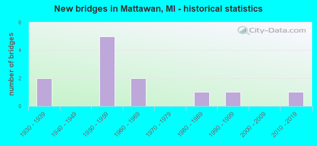
- New bridges - historical statistics
- 21930-1939
- 51950-1959
- 21960-1969
- 11980-1989
- 11990-1999
- 12010-2019

- Reconstructed bridges - Historical Statistics
- 11970-1979
- 11980-1989
- 21990-1999


- Bridge Condition - Deck
- 50.0%Good
- 33.3%Satisfactory
- 16.7%Fair

- Bridge Condition - Superstructure
- 33.3%Good
- 33.3%Satisfactory
- 16.7%Fair
- 16.7%Serious

- Bridge Condition - Substructure
- 66.7%Good
- 16.7%Satisfactory
- 16.7%Fair
Find on map >> Show street view
Structure Number: 4657, Location: 4.3MI W, 2MI S OF OSHTEMO (Lat: 42.230058, Lng: -85.759081), Route carried "on" structure: County highway , Year Built: 1992, Status: Open, Structure Length: 4.47m (14.67ft), Average Daily Traffic: 510 (year 2006), Truck Traffic: 3%, Average Future Daily Traffic: 750 (year 2024), Design Load: HS 20, Features Intersected: AMTRAK/CONRAIL RR, Facility Carried by Structure: O AVENUE
Minimum Vertical Clearance: 30.48m (100.00ft), Kilometerpoint: 1.038, Lanes on structure: 2, Owner: County Highway Agency, Approaching Roadway Width: 9.1m (29.9ft), Skew: 4 degrees, Material/Design: Prestressed concrete, Design/Construction: Box Beam or Girders - Multiple, Number Of Spans In Main Unit: 3, Length of Maximum Span: 14.4m (47.2ft), Curb-To-Curb Width: 9.4m (30.8ft), Out-to-Out Width: 10.5m (34.4ft)
Condition: Deck: Satisfactory, Superstructure: Good, Substructure: Good, Operating Rating: 58.6 metric tons, Method Used To Determine Operating Rating: Load and Resistance Factor Rating (LRFR) rating reported by rating factor(RF) method using HL-93 loadings, Inventory Rating: 34.7 metric tons, Method Used To Determine Inventory Rating: Load and Resistance Factor Rating (LRFR) rating reported by rating factor(RF) method using HL-93 loadings, Structural Evaluation: Better than present minimum criteria, Deck Geometry: Equal to present minimum criteria, Underclear: Meets minimum limits, Approach Roadway Alignment: Equal to present desirable criteria, Designated Inspection Frequency: Every 24 months, Inspection Date: April 2020, Deck Structure Type: Concrete Cast-file-Place, Wearing Surface/Protective System: Wearing Surface: Bituminous, Membrane: Built-up
Find on map >> Show street view
Structure Number: 10714, Location: 0.1 MI W OF KALAMAZOO COL (Lat: 42.222919, Lng: -85.767022), Route carried "on" structure: Interstate 94, Year Built: 1959, Year Reconstructed: 1999, Status: Open, Structure Length: 5.99m (19.65ft), Average Daily Traffic: 15,781 (year 2007), Truck Traffic: 25%, Average Future Daily Traffic: 25,165 (year 2018), Design Load: HS 25 or greater, Features Intersected: AMTRAK
Minimum Vertical Clearance: 30.48m (100.00ft), Kilometerpoint: 38.577, Lanes on structure: 2, Base Highway Network: Yes (Inventory Route: 58, Subroute: 5), Owner: State Highway Agency, Approaching Roadway Width: 12.8m (42.0ft), Skew: 5 degrees, Material/Design: Steel, Design/Construction: Stringer/Multi-beam, Number Of Spans In Main Unit: 3, Length of Maximum Span: 21.7m (71.2ft), Curb-To-Curb Width: 18.7m (61.4ft), Out-to-Out Width: 19.6m (64.3ft)
Condition: Deck: Good, Superstructure: Satisfactory, Substructure: Good, Operating Rating: 86.4 metric tons, Method Used To Determine Operating Rating: Load Factor (LF), Inventory Rating: 51.7 metric tons, Method Used To Determine Inventory Rating: Load Factor (LF), Structural Evaluation: Equal to present minimum criteria, Deck Geometry: Superior to present desirable criteria, Approach Roadway Alignment: Equal to present minimum criteria, Designated Inspection Frequency: Every 24 months, Inspection Date: October 2021, Deck Structure Type: Concrete Cast-file-Place, Wearing Surface/Protective System: Wearing Surface: Epoxy Overlay, Deck Protection: Epoxy Coated Reinforcing
Find on map >> Show street view
Structure Number: 10715, Location: 0.1 MI W OF KALAMAZOO COL (Lat: 42.223225, Lng: -85.766675), Route carried "on" structure: Interstate 94, Year Built: 1959, Year Reconstructed: 1999, Status: Open, Structure Length: 5.99m (19.65ft), Average Daily Traffic: 15,781 (year 2007), Truck Traffic: 29%, Average Future Daily Traffic: 21,264 (year 2018), Design Load: HS 25 or greater, Features Intersected: AMTRAK
Minimum Vertical Clearance: 30.48m (100.00ft), Kilometerpoint: 38.605, Lanes on structure: 2, Base Highway Network: Yes (Inventory Route: 58, Subroute: 3), Owner: State Highway Agency, Approaching Roadway Width: 12.8m (42.0ft), Skew: 5 degrees, Material/Design: Steel, Design/Construction: Stringer/Multi-beam, Number Of Spans In Main Unit: 3, Length of Maximum Span: 21.7m (71.2ft), Curb-To-Curb Width: 18.7m (61.4ft), Out-to-Out Width: 19.6m (64.3ft)
Condition: Deck: Good, Superstructure: Satisfactory, Substructure: Good, Operating Rating: 86.4 metric tons, Method Used To Determine Operating Rating: Load Factor (LF), Inventory Rating: 51.7 metric tons, Method Used To Determine Inventory Rating: Load Factor (LF), Structural Evaluation: Equal to present minimum criteria, Deck Geometry: Superior to present desirable criteria, Underclear: Equal to present minimum criteria, Approach Roadway Alignment: Equal to present desirable criteria, Designated Inspection Frequency: Every 24 months, Inspection Date: October 2021, Deck Structure Type: Concrete Cast-file-Place, Wearing Surface/Protective System: Wearing Surface: Epoxy Overlay, Deck Protection: Epoxy Coated Reinforcing
Find on map >> Show street view
Structure Number: 1072, Location: 3.0 MI W OF KALAMAZOO COL (Lat: 42.219797, Lng: -85.823828), Route carried "on" structure: County highway , Year Built: 1960, Year Reconstructed: 1993, Status: Open, Structure Length: 6.88m (22.57ft), Average Daily Traffic: 2,490 (year 1997), Truck Traffic: 3%, Average Future Daily Traffic: 3,700 (year 2015), Design Load: HS 20, Features Intersected: I-94, Facility Carried by Structure: 28 TH ST (CR657)
Minimum Vertical Clearance: 30.48m (100.00ft), Kilometerpoint: 8.644, Lanes on structure: 2, Lanes under structure: 4, Owner: State Highway Agency, Approaching Roadway Width: 7.2m (23.6ft), Material/Design: Prestressed concrete, Design/Construction: Stringer/Multi-beam, Number Of Spans In Main Unit: 4, Length of Maximum Span: 21.5m (70.5ft), Curb-To-Curb Width: 12.1m (39.7ft), Out-to-Out Width: 13.2m (43.3ft)
Condition: Deck: Good, Superstructure: Good, Substructure: Good, Operating Rating: 54.1 metric tons, Method Used To Determine Operating Rating: Load Factor (LF) rating reported by rating factor (RF) method using MS18 loading, Inventory Rating: 31.4 metric tons, Method Used To Determine Inventory Rating: Load Factor (LF) rating reported by rating factor (RF) method using MS18 loading, Structural Evaluation: Better than present minimum criteria, Deck Geometry: Somewhat better than minimum adequacy, Underclear: Meets minimum limits, Approach Roadway Alignment: Equal to present desirable criteria, Designated Inspection Frequency: Every 24 months, Inspection Date: October 2021, Bridge Improvement Cost: $158,000, Deck Structure Type: Concrete Cast-file-Place, Wearing Surface/Protective System: Wearing Surface: Monolithic Concrete, Deck Protection: Epoxy Coated Reinforcing
Find on map >> Show street view
Structure Number: 10721, Location: 1.0 MI W OF KALAMAZOO COL (Lat: 42.222817, Lng: -85.785383), Route carried "on" structure: City street 8095, Year Built: 1959, Year Reconstructed: 1981, Status: Open, Structure Length: 6.89m (22.60ft), Average Daily Traffic: 35,000 (year 2006), Truck Traffic: 28%, Average Future Daily Traffic: 45,000 (year 2026), Design Load: HS 20, Features Intersected: I-94, Facility Carried by Structure: 24 TH STREET
Minimum Vertical Clearance: 30.48m (100.00ft), Kilometerpoint: 9.220, Lanes on structure: 2, Lanes under structure: 4, Owner: State Highway Agency, Approaching Roadway Width: 10.3m (33.8ft), Material/Design: Concrete continuous, Design/Construction: Tee Beam, Number Of Spans In Main Unit: 4, Length of Maximum Span: 21.5m (70.5ft), Curb-To-Curb Width: 9.2m (30.2ft), Out-to-Out Width: 10.2m (33.5ft)
Condition: Deck: Fair, Superstructure: Fair, Substructure: Satisfactory, Operating Rating: 53.5 metric tons, Method Used To Determine Operating Rating: Load Factor (LF) rating reported by rating factor (RF) method using MS18 loading, Inventory Rating: 32.1 metric tons, Method Used To Determine Inventory Rating: Load Factor (LF) rating reported by rating factor (RF) method using MS18 loading, Structural Evaluation: Somewhat better than minimum adequacy, Deck Geometry: Meets minimum limits, Underclear: High priority of corrective action, Approach Roadway Alignment: Better than present minimum criteria, Designated Inspection Frequency: Every 24 months, Inspection Date: October 2021, Deck Structure Type: Concrete Cast-file-Place, Wearing Surface/Protective System: Wearing Surface: Latex Concrete
Find on map >> Show street view
Structure Number: 10803, Location: MATTAWAN MICHIGAN (Lat: 42.208925, Lng: -85.785161), Route carried "on" structure: City street 1050, Year Built: 1980, Status: Posted for load, Structure Length: 4.29m (14.07ft), Average Daily Traffic: 5,023 (year 2018), Truck Traffic: 6%, Average Future Daily Traffic: 7,464 (year 2030), Design Load: HS 20+Mod, Features Intersected: AMTRAK RAILROAD, Facility Carried by Structure: MAIN ST OVERPASS
Minimum Vertical Clearance: 30.48m (100.00ft), Kilometerpoint: 7.683, Lanes on structure: 2, Owner: City or Municipal Highway Agency, Approaching Roadway Width: 8.5m (27.9ft), Skew: 3 degrees, Material/Design: Concrete, Design/Construction: Box Beam or Girders - Multiple, Number Of Spans In Main Unit: 3, Length of Maximum Span: 18.6m (61.0ft), Curb or Sidewalk Widths: Left: 1.3m (4.3ft), Right: 1.3m (4.3ft), Curb-To-Curb Width: 8.5m (27.9ft), Out-to-Out Width: 12.5m (41.0ft)
Condition: Deck: Satisfactory, Superstructure: Serious, Substructure: Fair, Operating Rating: 18.5 metric tons, Method Used To Determine Operating Rating: Load Factor (LF) rating reported by rating factor (RF) method using MS18 loading, Inventory Rating: 11.3 metric tons, Method Used To Determine Inventory Rating: Load Factor (LF) rating reported by rating factor (RF) method using MS18 loading, Structural Evaluation: High priority of corrective action, Deck Geometry: High priority of replacement, Underclear: High priority of corrective action, Approach Roadway Alignment: Equal to present desirable criteria, Bridge Posting: Required (Relationship of Operating Rating to Maximum Legal Load: > 39.9% below), Designated Inspection Frequency: Every 12 months, Inspection Date: June 2021, Deck Structure Type: Concrete Precast Panels, Wearing Surface/Protective System: Wearing Surface: Bituminous, Membrane: Preformed Fabric
Find on map >> Show street view
Structure Number: 14308, Location: 0.19 MI NE OF DRAPE RD (Lat: 42.188633, Lng: -85.809719), Route carried "on" structure: County highway , Year Built: 2019, Status: Open, Structure Length: 0.63m (2.07ft), Average Daily Traffic: 225 (year 2019), Truck Traffic: 2%, Average Future Daily Traffic: 230 (year 2039), Design Load: Greater than HL93, Features Intersected: E BR PAW PAW RIVER, Facility Carried by Structure: 63RD AVE
Minimum Vertical Clearance: 30.48m (100.00ft), Kilometerpoint: 0.314, Lanes on structure: 2, Owner: County Highway Agency, Approaching Roadway Width: 7.9m (25.9ft), Material/Design: Aluminum, Iron, Design/Construction: Culvert, Number Of Spans In Main Unit: 1, Length of Maximum Span: 6.3m (20.7ft)
Condition: Channel: Very good, Culverts: Very good, Operating Rating: 40.5 metric tons, Method Used To Determine Operating Rating: Load and Resistance Factor Rating (LRFR) rating reported by rating factor(RF) method using HL-93 loadings, Inventory Rating: 31.1 metric tons, Method Used To Determine Inventory Rating: Load and Resistance Factor Rating (LRFR) rating reported by rating factor(RF) method using HL-93 loadings, Structural Evaluation: Better than present minimum criteria, Waterway Adequacy: Equal to present desirable criteria, Approach Roadway Alignment: Equal to present minimum criteria, Designated Inspection Frequency: Every 24 months, Inspection Date: April 2020, Wearing Surface/Protective System: Wearing Surface: Bituminous
Find on map >> Show street view
Structure Number: 4588, Location: 2.1 MI E OF VAN BUREN COL (Lat: 42.227903, Lng: -85.725728), Route carried "under" structure: Interstate 94, Year Built: 1959, Structure Length: 0. m, Average Daily Traffic: 31,562 (year 2007), Truck Traffic: 29%, Features Intersected: I-94, Facility Carried by Structure: 4 TH STREET
Minimum Vertical Clearance: 5.05m (16.57ft), Kilometerpoint: 3.405, Lanes on structure: 2, Lanes under structure: 4, Material/Design: Concrete continuous, Design/Construction: Tee Beam, Length of Maximum Span: 24.7m (81.0ft)
Find on map >> Show street view
Structure Number: 4628, Location: 3.4 MILES SW OF OSHTEMO (Lat: 42.246336, Lng: -85.741089), Route carried "under" structure: County highway 3948, Year Built: 1934, Structure Length: 0. m, Average Daily Traffic: 8,672 (year 2004), Truck Traffic: 5%, Features Intersected: STADIUM DRIVE, Facility Carried by Structure: AMTRAK
Minimum Vertical Clearance: 4.17m (13.68ft), Kilometerpoint: 2.124, Lanes under structure: 2, Material/Design: Steel, Design/Construction: Girder and Floorbeam System, Length of Maximum Span: 27.4m (89.9ft)
Find on map >> Show street view
Structure Number: 1072, Location: 3.0 MI W OF KALAMAZOO COL (Lat: 42.219797, Lng: -85.823828), Route carried "under" structure: Interstate 94, Year Built: 1960, Structure Length: 0. m, Average Daily Traffic: 36,704 (year 2007), Truck Traffic: 25%, Features Intersected: I-94, Facility Carried by Structure: 28 TH ST (CR657)
Minimum Vertical Clearance: 5.05m (16.57ft), Kilometerpoint: 33.870, Lanes on structure: 2, Lanes under structure: 4, Material/Design: Prestressed concrete, Design/Construction: Stringer/Multi-beam, Length of Maximum Span: 21.5m (70.5ft)
Find on map >> Show street view
Structure Number: 10721, Location: 1.0 MI W OF KALAMAZOO COL (Lat: 42.222817, Lng: -85.785383), Route carried "under" structure: Interstate 94, Year Built: 1959, Structure Length: 0. m, Average Daily Traffic: 36,704 (year 2007), Truck Traffic: 29%, Features Intersected: I-94, Facility Carried by Structure: 24 TH STREET
Minimum Vertical Clearance: 4.95m (16.24ft), Kilometerpoint: 37.063, Lanes on structure: 2, Lanes under structure: 4, Material/Design: Concrete continuous, Design/Construction: Tee Beam, Length of Maximum Span: 21.5m (70.5ft)
Find on map >> Show street view
Structure Number: 10804, Location: IN MATTAWAN (Lat: 42.200631, Lng: -85.796900), Route carried "under" structure: City street , Year Built: 1930, Structure Length: 0. m, Average Daily Traffic: 430 (year 1976), Features Intersected: ROBINSON AVE, Facility Carried by Structure: AMTRACK
Minimum Vertical Clearance: 3.63m (11.91ft), Kilometerpoint: 3.756, Lanes under structure: 2, Material/Design: Steel, Design/Construction: Stringer/Multi-beam, Length of Maximum Span: 12.2m (40.0ft)