Bridge Statistics for Mason City, Illinois (IL)
Condition, Traffic, Stress, Structural Evaluation, Project Costs
- National Bridge Inventory (NBI) Statistics
- 11Number of bridges
- 102ft / 30.9mTotal length
- 3,525Total average daily traffic
- 456Total average daily truck traffic
- National Bridge Inventory (NBI) Registered Bridges for Mason City
- No street view available for this location
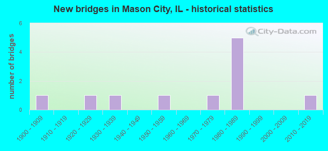
- New bridges - historical statistics
- 11900-1909
- 11920-1929
- 11930-1939
- 11950-1959
- 11970-1979
- 51980-1989
- 12010-2019


- Bridge Condition - Deck
- 22.2%Very good
- 33.3%Good
- 33.3%Satisfactory
- 11.1%Poor

- Bridge Condition - Superstructure
- 22.2%Very good
- 11.1%Good
- 33.3%Satisfactory
- 11.1%Fair
- 11.1%Poor
- 11.1%Serious

- Bridge Condition - Substructure
- 22.2%Very good
- 22.2%Good
- 22.2%Satisfactory
- 22.2%Fair
- 11.1%Poor

- Bridge Condition - Channel
- 10.0%Very good
- 30.0%Good
- 30.0%Satisfactory
- 30.0%Fair
Find on map >> Show street view
Structure Number: 630001, Location: 1.5M N MENARD COUNTY (Lat: 40.153592, Lng: -89.735589), Route carried "on" structure: State highway 29, Year Built: 1959, Status: Open, Structure Length: 0.97m (3.18ft), Average Daily Traffic: 1,600 (year 2021), Truck Traffic: 11%, Average Future Daily Traffic: 2,067 (year 2032), Design Load: HS 20, Features Intersected: SLEEPY HOLLOW DITCH
Minimum Vertical Clearance: 30+ m (98+ ft), Kilometerpoint: 117.173, Lanes on structure: 2, Base Highway Network: Yes, Owner: State Highway Agency, Approaching Roadway Width: 12.8m (42.0ft), Material/Design: Concrete, Design/Construction: Tee Beam, Number Of Spans In Main Unit: 1, Length of Maximum Span: 9.1m (29.9ft), Curb-To-Curb Width: 12.8m (42.0ft), Out-to-Out Width: 17.4m (57.1ft)
Condition: Deck: Satisfactory, Superstructure: Satisfactory, Substructure: Satisfactory, Channel: Satisfactory, Operating Rating: 89.1 metric tons, Method Used To Determine Operating Rating: Allowable Stress (AS) rating reported by rating factor (RF) method using MS18 loading, Inventory Rating: 89.1 metric tons, Method Used To Determine Inventory Rating: Allowable Stress (AS) rating reported by rating factor (RF) method using MS18 loading, Structural Evaluation: Equal to present minimum criteria, Deck Geometry: Better than present minimum criteria, Waterway Adequacy: Superior to present desirable criteria, Approach Roadway Alignment: Superior to present desirable criteria, Designated Inspection Frequency: Every 24 months, Inspection Date: March 2021
Find on map >> Show street view
Structure Number: 632007, Location: 1.0 MI W JCT I29/10 (Lat: 40.207000, Lng: -89.732875), Route carried "on" structure: State highway 10, Year Built: 1927, Status: Open, Structure Length: 0.79m (2.59ft), Average Daily Traffic: 1,150 (year 2021), Truck Traffic: 17%, Average Future Daily Traffic: 1,251 (year 2032), Design Load: HS 20, Features Intersected: DITCH
Minimum Vertical Clearance: 30+ m (98+ ft), Kilometerpoint: 17.203, Lanes on structure: 2, Owner: State Highway Agency, Approaching Roadway Width: 11.0m (36.1ft), Skew: 6 degrees, Material/Design: Concrete continuous, Design/Construction: Culvert, Number Of Spans In Main Unit: 2, Length of Maximum Span: 3.4m (11.2ft)
Condition: Channel: Good, Culverts: Good, Operating Rating: 57.7 metric tons, Method Used To Determine Operating Rating: Load Factor (LF) rating reported by rating factor (RF) method using MS18 loading, Inventory Rating: 34.3 metric tons, Method Used To Determine Inventory Rating: Load Factor (LF) rating reported by rating factor (RF) method using MS18 loading, Structural Evaluation: Better than present minimum criteria, Waterway Adequacy: Superior to present desirable criteria, Approach Roadway Alignment: Equal to present desirable criteria, Designated Inspection Frequency: Every 24 months, Inspection Date: January 2021
Find on map >> Show street view
Structure Number: 633033, Location: 4 M SW MASON CITY (Lat: 40.163981, Lng: -89.755150), Route carried "on" structure: County highway , Year Built: 2012, Status: Open, Structure Length: 3.66m (12.01ft), Average Daily Traffic: 275 (year 2019), Truck Traffic: 3%, Average Future Daily Traffic: 326 (year 2032), Design Load: HS 25 or greater, Features Intersected: SLEEPY HALLOW DITCH, Facility Carried by Structure: FAS 1595 (CH 19)
Minimum Vertical Clearance: 30+ m (98+ ft), Kilometerpoint: 8.932, Lanes on structure: 2, Owner: County Highway Agency, Approaching Roadway Width: 6.7m (22.0ft), Skew: 3 degrees, Material/Design: Prestressed concrete, Design/Construction: Box Beam or Girders - Multiple, Number Of Spans In Main Unit: 3, Length of Maximum Span: 16.8m (55.1ft), Curb-To-Curb Width: 9.1m (29.9ft), Out-to-Out Width: 9.1m (29.9ft)
Condition: Deck: Very good, Superstructure: Very good, Substructure: Very good, Channel: Very good, Operating Rating: 44.1 metric tons, Method Used To Determine Operating Rating: Assigned rating based on Load Factor Design (LFD) reported by rating factor (RF) using MS18 loading, Inventory Rating: 32.4 metric tons, Method Used To Determine Inventory Rating: Assigned rating based on Load Factor Design (LFD) reported by rating factor (RF) using MS18 loading, Structural Evaluation: Equal to present desirable criteria, Deck Geometry: Equal to present minimum criteria, Waterway Adequacy: Equal to present desirable criteria, Approach Roadway Alignment: Equal to present desirable criteria, Designated Inspection Frequency: Every 48 months, Inspection Date: October 2018, Deck Structure Type: Concrete Precast Panels, Wearing Surface/Protective System: Wearing Surface: Gravel
Find on map >> Show street view
Structure Number: 634203, Location: 1.5M SW MASON CITY (Lat: 40.178628, Lng: -89.722464), Route carried "on" structure: County highway , Year Built: 1983, Status: Open, Structure Length: 0.91m (2.99ft), Average Daily Traffic: 175 (year 2019), Truck Traffic: 23%, Average Future Daily Traffic: 163 (year 2032), Design Load: HS 20, Features Intersected: SW MASON CITY DITCH, Facility Carried by Structure: TR 171
Minimum Vertical Clearance: 30+ m (98+ ft), Kilometerpoint: 6.759, Lanes on structure: 2, Owner: Town or Township Highway Agency, Approaching Roadway Width: 5.1m (16.7ft), Skew: 1 degrees, Material/Design: Prestressed concrete, Design/Construction: Box Beam or Girders - Multiple, Number Of Spans In Main Unit: 1, Length of Maximum Span: 8.4m (27.6ft), Curb-To-Curb Width: 7.4m (24.3ft), Out-to-Out Width: 8.0m (26.2ft)
Condition: Deck: Satisfactory, Superstructure: Satisfactory, Substructure: Satisfactory, Channel: Fair, Operating Rating: 44.4 metric tons, Method Used To Determine Operating Rating: Assigned rating based on Load Factor Design (LFD) reported by rating factor (RF) using MS18 loading, Inventory Rating: 32.4 metric tons, Method Used To Determine Inventory Rating: Assigned rating based on Load Factor Design (LFD) reported by rating factor (RF) using MS18 loading, Structural Evaluation: Equal to present minimum criteria, Deck Geometry: Somewhat better than minimum adequacy, Waterway Adequacy: Better than present minimum criteria, Approach Roadway Alignment: Equal to present desirable criteria, Designated Inspection Frequency: Every 24 months, Inspection Date: July 2021, Deck Structure Type: Concrete Precast Panels, Wearing Surface/Protective System: Wearing Surface: Gravel
Find on map >> Show street view
Structure Number: 634208, Location: 4 SW OF MASON CITY (Lat: 40.175008, Lng: -89.759819), Route carried "on" structure: County highway , Year Built: 1986, Status: Temporarily open, Structure Length: 1.65m (5.41ft), Average Daily Traffic: 25 (year 2019), Truck Traffic: 32%, Average Future Daily Traffic: 27 (year 2032), Design Load: HS 20, Features Intersected: SLEEPY HOLLOW DITCH, Facility Carried by Structure: TR 208
Minimum Vertical Clearance: 30+ m (98+ ft), Kilometerpoint: 0.418, Lanes on structure: 2, Owner: Town or Township Highway Agency, Approaching Roadway Width: 4.3m (14.1ft), Material/Design: Steel, Design/Construction: Stringer/Multi-beam, Number Of Spans In Main Unit: 1, Length of Maximum Span: 15.7m (51.5ft), Curb-To-Curb Width: 7.3m (24.0ft), Out-to-Out Width: 8.0m (26.2ft)
Condition: Deck: Good, Superstructure: Serious, Substructure: Good, Channel: Satisfactory, Structural Evaluation: High priority of corrective action, Deck Geometry: Equal to present minimum criteria, Waterway Adequacy: Better than present minimum criteria, Approach Roadway Alignment: High priority of corrective action, Designated Inspection Frequency: Every 24 months, Other Special Inspection Frequency: Every 12 months, Inspection Date: August 2020, Other Special Inspection Date: July 2021, Deck Structure Type: Concrete Cast-file-Place, Wearing Surface/Protective System: Wearing Surface: Gravel
Find on map >> Show street view
Structure Number: 634301, Location: 3 MI ENE MASON CITY (Lat: 40.224125, Lng: -89.638925), Route carried "on" structure: County highway , Year Built: 1982, Status: Open, Structure Length: 1.04m (3.41ft), Average Daily Traffic: 25 (year 2019), Truck Traffic: 12%, Average Future Daily Traffic: 32 (year 2032), Design Load: HS 20, Features Intersected: BECKER DITCH, Facility Carried by Structure: TR 125
Minimum Vertical Clearance: 30+ m (98+ ft), Kilometerpoint: 1.722, Lanes on structure: 2, Owner: Town or Township Highway Agency, Approaching Roadway Width: 3.0m (9.8ft), Skew: 2 degrees, Material/Design: Prestressed concrete, Design/Construction: Box Beam or Girders - Multiple, Number Of Spans In Main Unit: 1, Length of Maximum Span: 9.6m (31.5ft), Curb-To-Curb Width: 7.4m (24.3ft), Out-to-Out Width: 7.4m (24.3ft)
Condition: Deck: Satisfactory, Superstructure: Satisfactory, Substructure: Fair, Channel: Fair, Operating Rating: 44.4 metric tons, Method Used To Determine Operating Rating: Assigned rating based on Load Factor Design (LFD) reported by rating factor (RF) using MS18 loading, Inventory Rating: 32.4 metric tons, Method Used To Determine Inventory Rating: Assigned rating based on Load Factor Design (LFD) reported by rating factor (RF) using MS18 loading, Structural Evaluation: Somewhat better than minimum adequacy, Deck Geometry: Equal to present minimum criteria, Waterway Adequacy: Better than present minimum criteria, Approach Roadway Alignment: Equal to present desirable criteria, Designated Inspection Frequency: Every 24 months, Inspection Date: July 2021, Deck Structure Type: Concrete Precast Panels
Find on map >> Show street view
Structure Number: 634308, Location: 3 MI SE MASON CITY (Lat: 40.180719, Lng: -89.640908), Route carried "on" structure: County highway , Year Built: 1900, Year Reconstructed: 1978, Status: Open, Structure Length: 1.14m (3.74ft), Average Daily Traffic: 50 (year 2019), Average Future Daily Traffic: 54 (year 2032), Features Intersected: ROGERS DITCH, Facility Carried by Structure: TR 268
Minimum Vertical Clearance: 30+ m (98+ ft), Kilometerpoint: 1.432, Lanes on structure: 1, Owner: Town or Township Highway Agency, Approaching Roadway Width: 4.7m (15.4ft), Material/Design: Steel, Design/Construction: Stringer/Multi-beam, Number Of Spans In Main Unit: 1, Length of Maximum Span: 10.6m (34.8ft), Curb-To-Curb Width: 7.2m (23.6ft), Out-to-Out Width: 7.4m (24.3ft)
Condition: Deck: Good, Superstructure: Fair, Substructure: Fair, Channel: Fair, Operating Rating: 35.0 metric tons, Method Used To Determine Operating Rating: Load Factor (LF) rating reported by rating factor (RF) method using MS18 loading, Inventory Rating: 21.1 metric tons, Method Used To Determine Inventory Rating: Load Factor (LF) rating reported by rating factor (RF) method using MS18 loading, Structural Evaluation: Somewhat better than minimum adequacy, Deck Geometry: Somewhat better than minimum adequacy, Waterway Adequacy: Equal to present minimum criteria, Approach Roadway Alignment: Somewhat better than minimum adequacy, Designated Inspection Frequency: Every 24 months, Inspection Date: July 2021, Deck Structure Type: Concrete Cast-file-Place, Wearing Surface/Protective System: Wearing Surface: Gravel
Find on map >> Show street view
Structure Number: 634317, Location: 3 MI NE MASON CITY (Lat: 40.218094, Lng: -89.630983), Route carried "on" structure: County highway , Year Built: 1983, Status: Open, Structure Length: 1.74m (5.71ft), Average Daily Traffic: 50 (year 2019), Average Future Daily Traffic: 27 (year 2032), Design Load: H 20, Features Intersected: PRARIE CREEK BRANCH, Facility Carried by Structure: TR 125
Minimum Vertical Clearance: 30+ m (98+ ft), Kilometerpoint: 3.042, Lanes on structure: 2, Owner: Town or Township Highway Agency, Approaching Roadway Width: 4.9m (16.1ft), Skew: 4 degrees, Material/Design: Prestressed concrete, Design/Construction: Box Beam or Girders - Multiple, Number Of Spans In Main Unit: 1, Length of Maximum Span: 16.6m (54.5ft), Curb-To-Curb Width: 7.4m (24.3ft), Out-to-Out Width: 7.4m (24.3ft)
Condition: Deck: Good, Superstructure: Good, Substructure: Good, Channel: Good, Operating Rating: 63.8 metric tons, Method Used To Determine Operating Rating: Load Factor (LF) rating reported by rating factor (RF) method using MS18 loading, Inventory Rating: 38.2 metric tons, Method Used To Determine Inventory Rating: Load Factor (LF) rating reported by rating factor (RF) method using MS18 loading, Structural Evaluation: Better than present minimum criteria, Deck Geometry: Equal to present minimum criteria, Waterway Adequacy: Equal to present minimum criteria, Approach Roadway Alignment: Better than present minimum criteria, Designated Inspection Frequency: Every 48 months, Inspection Date: September 2019, Deck Structure Type: Concrete Precast Panels, Wearing Surface/Protective System: Wearing Surface: Gravel
Find on map >> Show street view
Structure Number: 634803, Location: 3.5MI SW MASON CITY (Lat: 40.178564, Lng: -89.760261), Route carried "on" structure: County highway , Year Built: 1989, Status: Open, Structure Length: 1.65m (5.41ft), Average Daily Traffic: 50 (year 2019), Truck Traffic: 20%, Average Future Daily Traffic: 109 (year 2032), Design Load: HS 20, Features Intersected: SLEEPY HOLLOW BRANCH, Facility Carried by Structure: TR 171
Minimum Vertical Clearance: 30+ m (98+ ft), Kilometerpoint: 3.540, Lanes on structure: 2, Owner: Town or Township Highway Agency, Approaching Roadway Width: 5.9m (19.4ft), Skew: 1 degrees, Material/Design: Prestressed concrete, Design/Construction: Box Beam or Girders - Multiple, Number Of Spans In Main Unit: 1, Length of Maximum Span: 15.7m (51.5ft), Curb-To-Curb Width: 9.2m (30.2ft), Out-to-Out Width: 9.2m (30.2ft)
Condition: Deck: Very good, Superstructure: Very good, Substructure: Very good, Channel: Good, Operating Rating: 44.4 metric tons, Method Used To Determine Operating Rating: Assigned rating based on Load Factor Design (LFD) reported by rating factor (RF) using MS18 loading, Inventory Rating: 32.4 metric tons, Method Used To Determine Inventory Rating: Assigned rating based on Load Factor Design (LFD) reported by rating factor (RF) using MS18 loading, Structural Evaluation: Equal to present desirable criteria, Deck Geometry: Better than present minimum criteria, Waterway Adequacy: Equal to present desirable criteria, Approach Roadway Alignment: Equal to present desirable criteria, Designated Inspection Frequency: Every 48 months, Inspection Date: September 2019, Deck Structure Type: Concrete Precast Panels, Wearing Surface/Protective System: Wearing Surface: Gravel
Find on map >> Show street view
Structure Number: 653073, Location: 5.0 MI NE GREENVIEW (Lat: 40.155625, Lng: -89.672953), Route carried "on" structure: County highway , Year Built: 1978, Status: Open, Structure Length: 17.40m (57.09ft), Average Daily Traffic: 100 (year 2020), Truck Traffic: 13%, Average Future Daily Traffic: 135 (year 2032), Design Load: HS 20, Features Intersected: SALT CREEK, Facility Carried by Structure: FAS 1571
Minimum Vertical Clearance: 30+ m (98+ ft), Kilometerpoint: 0.000, Lanes on structure: 2, Owner: Town or Township Highway Agency, Approaching Roadway Width: 6.7m (22.0ft), Material/Design: Prestressed concrete, Design/Construction: Box Beam or Girders - Multiple, Number Of Spans In Main Unit: 7, Length of Maximum Span: 24.4m (80.1ft), Curb-To-Curb Width: 9.1m (29.9ft), Out-to-Out Width: 9.1m (29.9ft)
Condition: Deck: Poor, Superstructure: Poor, Substructure: Poor, Channel: Satisfactory, Operating Rating: 64.8 metric tons, Method Used To Determine Operating Rating: Load Factor (LF) rating reported by rating factor (RF) method using MS18 loading, Inventory Rating: 36.3 metric tons, Method Used To Determine Inventory Rating: Load Factor (LF) rating reported by rating factor (RF) method using MS18 loading, Structural Evaluation: Meets minimum limits, Deck Geometry: Better than present minimum criteria, Waterway Adequacy: Equal to present desirable criteria, Approach Roadway Alignment: Equal to present desirable criteria, Designated Inspection Frequency: Every 24 months, Underwater Inspection Frequency: Every 60 months, Inspection Date: September 2021, Underwater Inspection Date: August 2020, Deck Structure Type: Concrete Precast Panels, Wearing Surface/Protective System: Wearing Surface: Gravel
Find on map >> Show street view
Structure Number: 639901, Location: 2 M NE MASON CITY (Lat: 40.225158, Lng: -89.648189), Route carried "under" structure: County highway , Year Built: 1931, Structure Length: 0. m, Average Daily Traffic: 25 (year 2019), Truck Traffic: 12%, Features Intersected: TR 125, Facility Carried by Structure: C&NW RR
Minimum Vertical Clearance: 3.40m (11.15ft), Kilometerpoint: 0.821, Lanes under structure: 2, Material/Design: Steel, Design/Construction: Girder and Floorbeam System, Length of Maximum Span: 8.8m (28.9ft)