Bridge Statistics for Martin, Kentucky (KY)
Condition, Traffic, Stress, Structural Evaluation, Project Costs
- National Bridge Inventory (NBI) Statistics
- 14Number of bridges
- 302ft / 92.0mTotal length
- $11,420,000Total costs
- 57,096Total average daily traffic
- 5,472Total average daily truck traffic
- National Bridge Inventory (NBI) Registered Bridges for Martin
- No street view available for this location
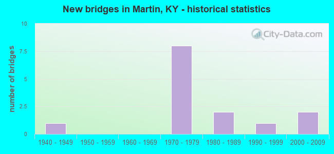
- New bridges - historical statistics
- 11940-1949
- 81970-1979
- 21980-1989
- 11990-1999
- 22000-2009


- Bridge Condition - Deck
- 30.0%Good
- 60.0%Satisfactory
- 10.0%Fair

- Bridge Condition - Superstructure
- 10.0%Very good
- 30.0%Good
- 50.0%Satisfactory
- 10.0%Fair

- Bridge Condition - Substructure
- 40.0%Good
- 30.0%Satisfactory
- 30.0%Fair

- Bridge Condition - Channel
- 60.0%Very good
- 30.0%Good
- 10.0%Fair
Find on map >> Show street view
Structure Number: 36B00057N, Location: 0.05 MI W of JCT KY 1428 (Lat: 37.572778, Lng: -82.754167), Route carried "on" structure: State highway 3190, Year Built: 1949, Status: Posted for load, Structure Length: 6.04m (19.82ft), Average Daily Traffic: 502 (year 2019), Average Future Daily Traffic: 436 (year 2039), Design Load: H 15, Features Intersected: BEAVER CREEK
Minimum Vertical Clearance: 30+ m (98+ ft), Kilometerpoint: 0.127, Lanes on structure: 2, Owner: State Highway Agency, Approaching Roadway Width: 6.1m (20.0ft), Material/Design: Concrete, Design/Construction: Tee Beam, Number Of Spans In Main Unit: 6, Length of Maximum Span: 9.1m (29.9ft), Curb or Sidewalk Widths: Left: 1.5m (4.9ft), Right: 0.3m (1.0ft), Curb-To-Curb Width: 6.1m (20.0ft), Out-to-Out Width: 8.5m (27.9ft)
Condition: Deck: Fair, Superstructure: Fair, Substructure: Fair, Channel: Good, Operating Rating: 39.3 metric tons, Method Used To Determine Operating Rating: Load Factor (LF), Inventory Rating: 23.6 metric tons, Method Used To Determine Inventory Rating: Load Factor (LF), Structural Evaluation: Somewhat better than minimum adequacy, Deck Geometry: High priority of corrective action, Waterway Adequacy: Equal to present minimum criteria, Approach Roadway Alignment: Equal to present minimum criteria, Bridge Posting: Required (Relationship of Operating Rating to Maximum Legal Load: > 39.9% below), Designated Inspection Frequency: Every 24 months, Inspection Date: September 2021, Deck Structure Type: Concrete Cast-file-Place, Wearing Surface/Protective System: Wearing Surface: Bituminous
Find on map >> Show street view
Structure Number: 36B00107N, Location: .1 MI N OF JCT KY 3188 (Lat: 37.551111, Lng: -82.772778), Route carried "on" structure: State highway 80, Year Built: 1978, Status: Open, Structure Length: 7.16m (23.49ft), Average Daily Traffic: 11,424 (year 2015), Truck Traffic: 8%, Average Future Daily Traffic: 10,738 (year 2035), Design Load: HS 20, Features Intersected: RT. FK-BEAVER CREEK
Minimum Vertical Clearance: 30+ m (98+ ft), Kilometerpoint: 12.320, Lanes on structure: 4, Base Highway Network: Yes, Owner: State Highway Agency, Approaching Roadway Width: 25.0m (82.0ft), Skew: 21 degrees, Material/Design: Prestressed concrete continuous, Design/Construction: Stringer/Multi-beam, Number Of Spans In Main Unit: 3, Length of Maximum Span: 23.5m (77.1ft), Curb-To-Curb Width: 24.9m (81.7ft), Out-to-Out Width: 25.8m (84.6ft)
Condition: Deck: Good, Superstructure: Satisfactory, Substructure: Satisfactory, Channel: Very good, Operating Rating: 99.8 metric tons, Method Used To Determine Operating Rating: Load Factor (LF), Inventory Rating: 63.4 metric tons, Method Used To Determine Inventory Rating: Load Factor (LF), Structural Evaluation: Equal to present minimum criteria, Deck Geometry: Superior to present desirable criteria, Waterway Adequacy: Equal to present desirable criteria, Approach Roadway Alignment: Equal to present desirable criteria, Designated Inspection Frequency: Every 24 months, Inspection Date: September 2021, Deck Structure Type: Concrete Cast-file-Place, Wearing Surface/Protective System: Wearing Surface: Monolithic Concrete
Find on map >> Show street view
Structure Number: 36B00108N, Location: 0.05 MI N of JCT KY 1210 (Lat: 37.556944, Lng: -82.770833), Route carried "on" structure: State highway 80, Year Built: 1978, Status: Open, Structure Length: 7.16m (23.49ft), Average Daily Traffic: 9,982 (year 2020), Truck Traffic: 8%, Average Future Daily Traffic: 9,383 (year 2040), Design Load: HS 20, Features Intersected: RT FRK BEAVER CREEK
Minimum Vertical Clearance: 30+ m (98+ ft), Kilometerpoint: 12.994, Lanes on structure: 4, Base Highway Network: Yes, Owner: State Highway Agency, Approaching Roadway Width: 25.0m (82.0ft), Skew: 21 degrees, Material/Design: Prestressed concrete continuous, Design/Construction: Stringer/Multi-beam, Number Of Spans In Main Unit: 3, Length of Maximum Span: 23.5m (77.1ft), Curb-To-Curb Width: 24.9m (81.7ft), Out-to-Out Width: 26.0m (85.3ft)
Condition: Deck: Satisfactory, Superstructure: Satisfactory, Substructure: Satisfactory, Channel: Very good, Operating Rating: 62.6 metric tons, Method Used To Determine Operating Rating: Load Factor (LF), Inventory Rating: 42.8 metric tons, Method Used To Determine Inventory Rating: Load Factor (LF), Structural Evaluation: Equal to present minimum criteria, Deck Geometry: Superior to present desirable criteria, Waterway Adequacy: Equal to present desirable criteria, Approach Roadway Alignment: Equal to present desirable criteria, Designated Inspection Frequency: Every 24 months, Inspection Date: September 2021, Deck Structure Type: Concrete Cast-file-Place, Wearing Surface/Protective System: Wearing Surface: Monolithic Concrete
Find on map >> Show street view
Structure Number: 36B00109N, Location: N @ S-JCT of KY 122 (Lat: 37.562778, Lng: -82.763611), Route carried "on" structure: State highway 80, Year Built: 1978, Status: Open, Structure Length: 18.90m (62.01ft), Average Daily Traffic: 8,854 (year 2020), Truck Traffic: 16%, Average Future Daily Traffic: 8,322 (year 2040), Design Load: HS 20, Features Intersected: CSX/R F Beaver/Denwood
Minimum Vertical Clearance: 30+ m (98+ ft), Kilometerpoint: 13.914, Lanes on structure: 4, Lanes under structure: 2, Base Highway Network: Yes, Owner: State Highway Agency, Approaching Roadway Width: 25.0m (82.0ft), Skew: 24 degrees, Material/Design: Prestressed concrete continuous, Design/Construction: Stringer/Multi-beam, Number Of Spans In Main Unit: 7, Length of Maximum Span: 28.3m (92.8ft), Curb-To-Curb Width: 24.9m (81.7ft), Out-to-Out Width: 26.0m (85.3ft)
Condition: Deck: Satisfactory, Superstructure: Satisfactory, Substructure: Fair, Channel: Very good, Operating Rating: 99.8 metric tons, Method Used To Determine Operating Rating: Load Factor (LF), Inventory Rating: 65.2 metric tons, Method Used To Determine Inventory Rating: Load Factor (LF), Structural Evaluation: Somewhat better than minimum adequacy, Deck Geometry: Superior to present desirable criteria, Underclear: Superior to present desirable criteria, Waterway Adequacy: Equal to present desirable criteria, Approach Roadway Alignment: Equal to present desirable criteria, Length Of Structure Improvement: 1.89m (6.20ft), Designated Inspection Frequency: Every 24 months, Inspection Date: September 2021, Bridge Improvement Cost: $6,588,000, Total Project Cost: $6,587,000, Deck Structure Type: Concrete Cast-file-Place, Wearing Surface/Protective System: Wearing Surface: Monolithic Concrete
Find on map >> Show street view
Structure Number: 36B00110N, Location: SE @JCT NEW KY 80 @MARTIN (Lat: 37.570833, Lng: -82.755556), Route carried "on" structure: Spur State highway 80, Year Built: 1978, Status: Open, Structure Length: 24.32m (79.79ft), Average Daily Traffic: 1,947 (year 2020), Average Future Daily Traffic: 1,713 (year 2040), Design Load: HS 20, Features Intersected: CSX RR/Beaver/Old RR St
Minimum Vertical Clearance: 30+ m (98+ ft), Kilometerpoint: 0.217, Lanes on structure: 2, Lanes under structure: 3, Owner: State Highway Agency, Approaching Roadway Width: 13.4m (44.0ft), Material/Design: Prestressed concrete continuous, Design/Construction: Stringer/Multi-beam, Number Of Spans In Main Unit: 8, Length of Maximum Span: 31.7m (104.0ft), Curb-To-Curb Width: 13.5m (44.3ft), Out-to-Out Width: 14.5m (47.6ft)
Condition: Deck: Satisfactory, Superstructure: Good, Substructure: Satisfactory, Channel: Very good, Operating Rating: 70.6 metric tons, Method Used To Determine Operating Rating: Load Factor (LF), Inventory Rating: 42.4 metric tons, Method Used To Determine Inventory Rating: Load Factor (LF), Structural Evaluation: Equal to present minimum criteria, Deck Geometry: Superior to present desirable criteria, Underclear: Meets minimum limits, Waterway Adequacy: Equal to present desirable criteria, Approach Roadway Alignment: Equal to present desirable criteria, Length Of Structure Improvement: 2.43m (7.97ft), Designated Inspection Frequency: Every 24 months, Inspection Date: September 2021, Bridge Improvement Cost: $4,748,000, Total Project Cost: $4,748,000, Deck Structure Type: Concrete Cast-file-Place, Wearing Surface/Protective System: Wearing Surface: Monolithic Concrete
Find on map >> Show street view
Structure Number: 36B00121N, Location: .4 MI N JCT KY 122 (Lat: 37.573611, Lng: -82.757222), Route carried "on" structure: State highway 80, Year Built: 1987, Status: Open, Structure Length: 1.04m (3.41ft), Average Daily Traffic: 8,854 (year 2020), Truck Traffic: 16%, Average Future Daily Traffic: 8,322 (year 2040), Design Load: HS 20, Features Intersected: CSX RR SPUR @ BUCKS BR
Minimum Vertical Clearance: 30+ m (98+ ft), Kilometerpoint: 15.331, Lanes on structure: 4, Base Highway Network: Yes, Owner: State Highway Agency, Approaching Roadway Width: 26.2m (86.0ft), Skew: 23 degrees, Material/Design: Concrete, Design/Construction: Culvert, Number Of Spans In Main Unit: 1, Length of Maximum Span: 9.1m (29.9ft), Curb-To-Curb Width: 26.2m (86.0ft), Out-to-Out Width: 26.2m (86.0ft)
Condition: Culverts: Good, Operating Rating: 99.8 metric tons, Method Used To Determine Operating Rating: Load Factor (LF), Inventory Rating: 99.8 metric tons, Method Used To Determine Inventory Rating: Load Factor (LF), Structural Evaluation: Better than present minimum criteria, Deck Geometry: Superior to present desirable criteria, Underclear: Equal to present minimum criteria, Approach Roadway Alignment: Equal to present desirable criteria, Length Of Structure Improvement: 0.10m (0.33ft), Designated Inspection Frequency: Every 24 months, Inspection Date: September 2021, Bridge Improvement Cost: $85,000, Total Project Cost: $85,000
Find on map >> Show street view
Structure Number: 36B00138N, Location: .01 MI. E. JCT KY 122 (Lat: 37.534722, Lng: -82.743611), Route carried "on" structure: State highway 2030, Year Built: 1997, Status: Open, Structure Length: 2.99m (9.81ft), Average Daily Traffic: 861 (year 2019), Average Future Daily Traffic: 757 (year 2039), Design Load: HS 25 or greater, Features Intersected: LEFT FK-BEAVLR-FK
Minimum Vertical Clearance: 30+ m (98+ ft), Kilometerpoint: 0.188, Lanes on structure: 2, Owner: State Highway Agency, Approaching Roadway Width: 8.2m (26.9ft), Material/Design: Prestressed concrete, Design/Construction: Box Beam or Girders - Multiple, Number Of Spans In Main Unit: 1, Length of Maximum Span: 29.0m (95.1ft), Curb-To-Curb Width: 8.0m (26.2ft), Out-to-Out Width: 8.5m (27.9ft)
Condition: Deck: Satisfactory, Superstructure: Good, Substructure: Good, Channel: Good, Operating Rating: 93.0 metric tons, Method Used To Determine Operating Rating: Load Factor (LF), Inventory Rating: 55.8 metric tons, Method Used To Determine Inventory Rating: Load Factor (LF), Structural Evaluation: Better than present minimum criteria, Deck Geometry: Somewhat better than minimum adequacy, Waterway Adequacy: Equal to present desirable criteria, Approach Roadway Alignment: Equal to present minimum criteria, Designated Inspection Frequency: Every 24 months, Inspection Date: September 2020, Deck Structure Type: Concrete Cast-file-Place, Wearing Surface/Protective System: Wearing Surface: Monolithic Concrete, Deck Protection: Epoxy Coated Reinforcing
Find on map >> Show street view
Structure Number: 36B00141N, Location: MARTIN - BEAVER CREEK (Lat: 37.564722, Lng: -82.758611), Route carried "on" structure: State highway 1428, Year Built: 2002, Status: Open, Structure Length: 8.72m (28.61ft), Average Daily Traffic: 4,204 (year 2020), Truck Traffic: 10%, Average Future Daily Traffic: 3,699 (year 2040), Design Load: HS 25 or greater, Features Intersected: BEAVER CREEK
Minimum Vertical Clearance: 30+ m (98+ ft), Kilometerpoint: 0.504, Lanes on structure: 2, Owner: State Highway Agency, Approaching Roadway Width: 9.9m (32.5ft), Skew: 2 degrees, Material/Design: Prestressed concrete continuous, Design/Construction: Box Beam or Girders - Single/Spread, Number Of Spans In Main Unit: 4, Length of Maximum Span: 25.0m (82.0ft), Curb or Sidewalk Widths: Left: 0.0m, Right: 1.5m (4.9ft), Curb-To-Curb Width: 9.6m (31.5ft), Out-to-Out Width: 12.2m (40.0ft)
Condition: Deck: Good, Superstructure: Good, Substructure: Good, Channel: Very good, Operating Rating: 83.9 metric tons, Method Used To Determine Operating Rating: Load Factor (LF), Inventory Rating: 50.3 metric tons, Method Used To Determine Inventory Rating: Load Factor (LF), Structural Evaluation: Better than present minimum criteria, Deck Geometry: Meets minimum limits, Waterway Adequacy: Equal to present desirable criteria, Approach Roadway Alignment: Equal to present desirable criteria, Designated Inspection Frequency: Every 24 months, Inspection Date: September 2020, Deck Structure Type: Concrete Cast-file-Place, Wearing Surface/Protective System: Wearing Surface: Monolithic Concrete, Deck Protection: Epoxy Coated Reinforcing
Find on map >> Show street view
Structure Number: 36B00142N, Location: MARTIN / RIGHT BEAVER CRK (Lat: 37.562778, Lng: -82.759722), Route carried "on" structure: State highway 1428, Year Built: 2002, Status: Open, Structure Length: 7.47m (24.51ft), Average Daily Traffic: 5,092 (year 2015), Truck Traffic: 10%, Average Future Daily Traffic: 4,480 (year 2035), Design Load: HS 25 or greater, Features Intersected: RIGHT FK OF BEAVER CREEK
Minimum Vertical Clearance: 30+ m (98+ ft), Kilometerpoint: 0.270, Lanes on structure: 2, Owner: State Highway Agency, Approaching Roadway Width: 9.4m (30.8ft), Skew: 3 degrees, Material/Design: Prestressed concrete continuous, Design/Construction: Stringer/Multi-beam, Number Of Spans In Main Unit: 3, Length of Maximum Span: 30.8m (101.0ft), Curb or Sidewalk Widths: Left: 0.0m, Right: 1.5m (4.9ft), Curb-To-Curb Width: 9.6m (31.5ft), Out-to-Out Width: 12.2m (40.0ft)
Condition: Deck: Good, Superstructure: Very good, Substructure: Good, Channel: Very good, Operating Rating: 73.7 metric tons, Method Used To Determine Operating Rating: Load Factor (LF), Inventory Rating: 44.2 metric tons, Method Used To Determine Inventory Rating: Load Factor (LF), Structural Evaluation: Better than present minimum criteria, Deck Geometry: Meets minimum limits, Waterway Adequacy: Equal to present desirable criteria, Approach Roadway Alignment: Equal to present desirable criteria, Designated Inspection Frequency: Every 24 months, Inspection Date: September 2020, Deck Structure Type: Concrete Cast-file-Place, Wearing Surface/Protective System: Wearing Surface: Monolithic Concrete, Deck Protection: Epoxy Coated Reinforcing
Find on map >> Show street view
Structure Number: 36C00041N, Location: 0.1 W. OF NEW KY 80 (Lat: 37.545833, Lng: -82.775000), Route carried "on" structure: County highway 1917, Year Built: 1979, Status: Open, Structure Length: 5.97m (19.59ft), Average Daily Traffic: 234 (year 2011), Average Future Daily Traffic: 203 (year 2031), Design Load: HS 20, Features Intersected: RT. FRK.-BEAVER CREEK, Facility Carried by Structure: WARCO RD
Minimum Vertical Clearance: 30+ m (98+ ft), Kilometerpoint: 0.124, Lanes on structure: 2, Owner: County Highway Agency, Approaching Roadway Width: 4.9m (16.1ft), Material/Design: Prestressed concrete, Design/Construction: Box Beam or Girders - Multiple, Number Of Spans In Main Unit: 3, Length of Maximum Span: 24.4m (80.1ft), Curb-To-Curb Width: 7.1m (23.3ft), Out-to-Out Width: 7.1m (23.3ft)
Condition: Deck: Satisfactory, Superstructure: Satisfactory, Substructure: Good, Channel: Good, Operating Rating: 99.5 metric tons, Method Used To Determine Operating Rating: Load Factor (LF), Inventory Rating: 59.7 metric tons, Method Used To Determine Inventory Rating: Load Factor (LF), Structural Evaluation: Equal to present minimum criteria, Deck Geometry: Meets minimum limits, Waterway Adequacy: Better than present minimum criteria, Approach Roadway Alignment: Equal to present minimum criteria, Designated Inspection Frequency: Every 24 months, Inspection Date: July 2021, Deck Structure Type: Concrete Precast Panels
Find on map >> Show street view
Structure Number: 36C00043N, Location: 0.18 MI E of JCT KY 122 (Lat: 37.517500, Lng: -82.751667), Route carried "on" structure: County highway 1231, Year Built: 1981, Status: Closed, Structure Length: 2.19m (7.19ft), Average Daily Traffic: 154 (year 2011), Average Future Daily Traffic: 133 (year 2031), Design Load: HS 20, Features Intersected: Left Frk Beaver Crk, Facility Carried by Structure: Shop Branch
Minimum Vertical Clearance: 30+ m (98+ ft), Kilometerpoint: 0.290, Lanes on structure: 2, Owner: County Highway Agency, Approaching Roadway Width: 3.7m (12.1ft), Material/Design: Prestressed concrete, Design/Construction: Box Beam or Girders - Multiple, Number Of Spans In Main Unit: 2, Length of Maximum Span: 8.8m (28.9ft), Curb-To-Curb Width: 5.9m (19.4ft), Out-to-Out Width: 6.4m (21.0ft)
Condition: Deck: Satisfactory, Superstructure: Satisfactory, Substructure: Fair, Channel: Fair, Operating Rating: 0.2 metric tons, Method Used To Determine Operating Rating: Field evaluation and documented engineering judgment, Inventory Rating: 0.1 metric tons, Method Used To Determine Inventory Rating: Field evaluation and documented engineering judgment, Deck Geometry: High priority of corrective action, Waterway Adequacy: Equal to present minimum criteria, Approach Roadway Alignment: High priority of corrective action, Bridge Posting: Required (Relationship of Operating Rating to Maximum Legal Load: > 39.9% below), Designated Inspection Frequency: Every 12 months, Inspection Date: July 2021, Deck Structure Type: Concrete Precast Panels
Find on map >> Show street view
Structure Number: 36B00109N, Location: N @ S-JCT of KY 122 (Lat: 37.562778, Lng: -82.763611), Route carried "under" structure: County highway 1237, Year Built: 1978, Structure Length: 0. m, Average Daily Traffic: 100 (year 2006), Features Intersected: CSX/R F Beaver/Denwood, Facility Carried by Structure: KY-80
Minimum Vertical Clearance: 30+ m (98+ ft), Kilometerpoint: 0.360, Lanes on structure: 4, Lanes under structure: 2, Material/Design: Prestressed concrete continuous, Design/Construction: Stringer/Multi-beam, Length of Maximum Span: 28.3m (92.8ft)
Find on map >> Show street view
Structure Number: 36B00110N, Location: SE @JCT NEW KY 80 @MARTIN (Lat: 37.570833, Lng: -82.755556), Route carried "under" structure: County highway 1330, Year Built: 1978, Structure Length: 0. m, Average Daily Traffic: 2,444 (year 2006), Features Intersected: CSX RR/Beaver/Old RR St, Facility Carried by Structure: KY-80S
Minimum Vertical Clearance: 30+ m (98+ ft), Kilometerpoint: 0.127, Lanes on structure: 2, Lanes under structure: 2, Material/Design: Prestressed concrete continuous, Design/Construction: Stringer/Multi-beam, Length of Maximum Span: 31.7m (104.0ft)
Find on map >> Show street view
Structure Number: 36B00110N, Location: SE @JCT NEW KY 80 @MARTIN (Lat: 37.570833, Lng: -82.755556), Route carried "under" structure: City street 3012, Year Built: 1978, Structure Length: 0. m, Average Daily Traffic: 2,444 (year 2006), Features Intersected: CSX RR/Beaver/Old RR St, Facility Carried by Structure: KY-80S
Minimum Vertical Clearance: 30+ m (98+ ft), Kilometerpoint: 0.002, Lanes on structure: 2, Lanes under structure: 1, Material/Design: Prestressed concrete continuous, Design/Construction: Stringer/Multi-beam, Length of Maximum Span: 31.7m (104.0ft)