Bridge Statistics for Marston, Missouri (MO)
Condition, Traffic, Stress, Structural Evaluation, Project Costs
- National Bridge Inventory (NBI) Statistics
- 11Number of bridges
- 85ft / 26.1mTotal length
- 56,106Total average daily traffic
- 32,925Total average daily truck traffic
- National Bridge Inventory (NBI) Registered Bridges for Marston
- No street view available for this location
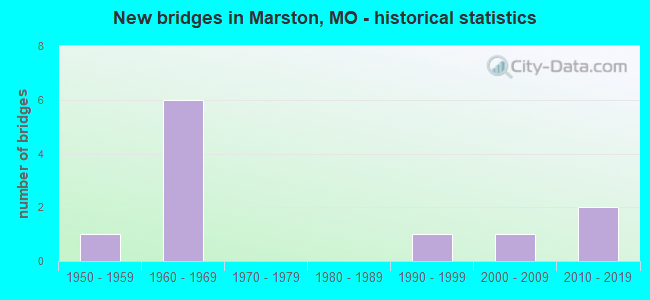
- New bridges - historical statistics
- 11950-1959
- 61960-1969
- 11990-1999
- 12000-2009
- 22010-2019


- Bridge Condition - Deck
- 28.6%Very good
- 28.6%Good
- 14.3%Satisfactory
- 28.6%Fair

- Bridge Condition - Superstructure
- 42.9%Very good
- 14.3%Good
- 28.6%Satisfactory
- 14.3%Fair

- Bridge Condition - Substructure
- 28.6%Excellent
- 28.6%Very good
- 28.6%Good
- 14.3%Fair

- Bridge Condition - Channel
- 40.0%Very good
- 40.0%Good
- 20.0%Satisfactory
Find on map >> Show street view
Structure Number: 1051, Location: S 25 T 22 N R 13 E (Lat: 36.518833, Lng: -89.600786), Route carried "on" structure: State highway EE, Year Built: 1966, Year Reconstructed: 2003, Status: Open, Structure Length: 7.04m (23.10ft), Average Daily Traffic: 2,351 (year 2021), Truck Traffic: 20%, Average Future Daily Traffic: 3,644 (year 2041), Design Load: H 20, Features Intersected: IS 55
Minimum Vertical Clearance: 30+ m (98+ ft), Kilometerpoint: 12.513, Lanes on structure: 2, Lanes under structure: 4, Base Highway Network: Yes, Owner: State Highway Agency, Approaching Roadway Width: 7.3m (24.0ft), Skew: 2 degrees, Material/Design: Concrete continuous, Design/Construction: Slab, Number Of Spans In Main Unit: 4, Length of Maximum Span: 21.2m (69.6ft), Curb-To-Curb Width: 8.5m (27.9ft), Out-to-Out Width: 9.4m (30.8ft)
Condition: Deck: Fair, Superstructure: Fair, Substructure: Good, Operating Rating: 47.7 metric tons, Method Used To Determine Operating Rating: Allowable Stress (AS), Inventory Rating: 26.1 metric tons, Method Used To Determine Inventory Rating: Allowable Stress (AS), Structural Evaluation: Somewhat better than minimum adequacy, Deck Geometry: Meets minimum limits, Underclear: Meets minimum limits, Approach Roadway Alignment: Equal to present minimum criteria, Designated Inspection Frequency: Every 24 months, Inspection Date: December 2020, Deck Structure Type: Concrete Cast-file-Place, Wearing Surface/Protective System: Wearing Surface: Monolithic Concrete, Deck Protection: Internally Sealed
Find on map >> Show street view
Structure Number: 1507, Location: S 3 T 21 N R 13 E (Lat: 36.483481, Lng: -89.631767), Route carried "on" structure: State highway M, Year Built: 1966, Status: Posted for load, Structure Length: 8.05m (26.41ft), Average Daily Traffic: 220 (year 2021), Truck Traffic: 11%, Average Future Daily Traffic: 341 (year 2041), Design Load: H 15, Features Intersected: IS 55
Minimum Vertical Clearance: 30+ m (98+ ft), Kilometerpoint: 0.781, Lanes on structure: 2, Lanes under structure: 4, Owner: State Highway Agency, Approaching Roadway Width: 6.1m (20.0ft), Skew: 3 degrees, Material/Design: Steel continuous, Design/Construction: Stringer/Multi-beam, Number Of Spans In Main Unit: 4, Length of Maximum Span: 24.4m (80.1ft), Curb-To-Curb Width: 7.9m (25.9ft), Out-to-Out Width: 8.7m (28.5ft)
Condition: Deck: Fair, Superstructure: Satisfactory, Substructure: Good, Operating Rating: 27.9 metric tons, Method Used To Determine Operating Rating: Allowable Stress (AS), Inventory Rating: 14.4 metric tons, Method Used To Determine Inventory Rating: Allowable Stress (AS), Structural Evaluation: Meets minimum limits, Deck Geometry: Somewhat better than minimum adequacy, Underclear: Meets minimum limits, Approach Roadway Alignment: Equal to present minimum criteria, Bridge Posting: Required (Relationship of Operating Rating to Maximum Legal Load: 0.1 - 9.9% below), Designated Inspection Frequency: Every 24 months, Inspection Date: December 2020, Deck Structure Type: Concrete Cast-file-Place, Wearing Surface/Protective System: Wearing Surface: Bituminous, Deck Protection: Internally Sealed
Find on map >> Show street view
Structure Number: 28693, Location: S 33 T 22 N R 13 E (Lat: 36.504583, Lng: -89.646083), Route carried "on" structure: County highway 252, Year Built: 1999, Status: Open, Structure Length: 1.16m (3.81ft), Average Daily Traffic: 15 (year 2021), Truck Traffic: 20%, Average Future Daily Traffic: 20 (year 2041), Features Intersected: DRAIN DTCH, Facility Carried by Structure: COUNTY RD 311
Minimum Vertical Clearance: 30+ m (98+ ft), Kilometerpoint: 1.609, Lanes on structure: 2, Owner: County Highway Agency, Approaching Roadway Width: 7.3m (24.0ft), Material/Design: Concrete, Design/Construction: Channel Beam, Number Of Spans In Main Unit: 1, Length of Maximum Span: 11.0m (36.1ft), Curb-To-Curb Width: 7.3m (24.0ft), Out-to-Out Width: 7.3m (24.0ft)
Condition: Deck: Good, Superstructure: Good, Substructure: Excellent, Channel: Very good, Operating Rating: 89.1 metric tons, Method Used To Determine Operating Rating: Load Factor (LF), Inventory Rating: 82.8 metric tons, Method Used To Determine Inventory Rating: Load Factor (LF), Structural Evaluation: Better than present minimum criteria, Deck Geometry: Equal to present minimum criteria, Waterway Adequacy: Better than present minimum criteria, Approach Roadway Alignment: Equal to present desirable criteria, Designated Inspection Frequency: Every 24 months, Inspection Date: December 2020, Deck Structure Type: Concrete Precast Panels, Wearing Surface/Protective System: Wearing Surface: Monolithic Concrete
Find on map >> Show street view
Structure Number: 32156, Location: S 14 T 21 N R 13 E (Lat: 36.461819, Lng: -89.613772), Route carried "on" structure: County highway 420, Year Built: 2005, Status: Open, Structure Length: 2.02m (6.63ft), Average Daily Traffic: 5 (year 2021), Truck Traffic: 10%, Average Future Daily Traffic: 7 (year 2041), Design Load: HS 20, Features Intersected: PORTAGE BYU
Minimum Vertical Clearance: 30+ m (98+ ft), Kilometerpoint: 0.000, Lanes on structure: 2, Owner: County Highway Agency, Approaching Roadway Width: 6.7m (22.0ft), Material/Design: Concrete continuous, Design/Construction: Channel Beam, Number Of Spans In Main Unit: 3, Length of Maximum Span: 6.7m (22.0ft), Curb-To-Curb Width: 7.4m (24.3ft), Out-to-Out Width: 7.5m (24.6ft)
Condition: Deck: Very good, Superstructure: Very good, Substructure: Very good, Channel: Good, Inventory Rating: 84.6 metric tons, Method Used To Determine Inventory Rating: Load Factor (LF), Structural Evaluation: Equal to present desirable criteria, Deck Geometry: Equal to present minimum criteria, Waterway Adequacy: Equal to present minimum criteria, Approach Roadway Alignment: Equal to present desirable criteria, Designated Inspection Frequency: Every 24 months, Inspection Date: December 2020, Deck Structure Type: Concrete Precast Panels, Wearing Surface/Protective System: Wearing Surface: Bituminous
Find on map >> Show street view
Structure Number: 33113, Location: S 4 T 21 N R 13 E (Lat: 36.483239, Lng: -89.647994), Route carried "on" structure: State highway F, Year Built: 2011, Status: Open, Structure Length: 3.47m (11.38ft), Average Daily Traffic: 262 (year 2021), Truck Traffic: 7%, Average Future Daily Traffic: 406 (year 2041), Design Load: HS 20, Features Intersected: DRAIN DITCH #18
Minimum Vertical Clearance: 30+ m (98+ ft), Kilometerpoint: 0.605, Lanes on structure: 2, Owner: State Highway Agency, Approaching Roadway Width: 7.3m (24.0ft), Skew: 4 degrees, Material/Design: Prestressed concrete, Design/Construction: Box Beam or Girders - Single/Spread, Number Of Spans In Main Unit: 3, Length of Maximum Span: 12.2m (40.0ft), Curb-To-Curb Width: 7.3m (24.0ft), Out-to-Out Width: 7.9m (25.9ft)
Condition: Deck: Good, Superstructure: Very good, Substructure: Very good, Channel: Good, Operating Rating: 78.3 metric tons, Method Used To Determine Operating Rating: Load Factor (LF), Inventory Rating: 46.8 metric tons, Method Used To Determine Inventory Rating: Load Factor (LF), Structural Evaluation: Equal to present desirable criteria, Deck Geometry: Somewhat better than minimum adequacy, Waterway Adequacy: Superior to present desirable criteria, Approach Roadway Alignment: Equal to present desirable criteria, Designated Inspection Frequency: Every 24 months, Inspection Date: December 2020, Deck Structure Type: Concrete Cast-file-Place, Wearing Surface/Protective System: Wearing Surface: Monolithic Concrete, Deck Protection: Epoxy Coated Reinforcing
Find on map >> Show street view
Structure Number: 34901, Location: S 17 T 22 N R 13 E (Lat: 36.540833, Lng: -89.663889), Route carried "on" structure: County highway 268, Year Built: 2014, Status: Open, Structure Length: 1.45m (4.76ft), Average Daily Traffic: 15 (year 2021), Truck Traffic: 10%, Average Future Daily Traffic: 20 (year 2041), Design Load: HS 20, Features Intersected: DRAIN DTCH, Facility Carried by Structure: COUNTY RD 313
Minimum Vertical Clearance: 30+ m (98+ ft), Kilometerpoint: 1.609, Lanes on structure: 2, Owner: County Highway Agency, Approaching Roadway Width: 6.7m (22.0ft), Skew: 4 degrees, Material/Design: Prestressed concrete, Design/Construction: Box Beam or Girders - Multiple, Number Of Spans In Main Unit: 1, Length of Maximum Span: 13.7m (44.9ft), Curb-To-Curb Width: 7.3m (24.0ft), Out-to-Out Width: 7.3m (24.0ft)
Condition: Deck: Very good, Superstructure: Very good, Substructure: Excellent, Channel: Very good, Operating Rating: 55.8 metric tons, Method Used To Determine Operating Rating: Load Factor (LF), Inventory Rating: 33.3 metric tons, Method Used To Determine Inventory Rating: Load Factor (LF), Structural Evaluation: Equal to present desirable criteria, Deck Geometry: Equal to present minimum criteria, Waterway Adequacy: Superior to present desirable criteria, Approach Roadway Alignment: Equal to present desirable criteria, Designated Inspection Frequency: Every 24 months, Inspection Date: December 2020, Deck Structure Type: Concrete Precast Panels, Wearing Surface/Protective System: Wearing Surface: Monolithic Concrete
Find on map >> Show street view
Structure Number: 359, Location: S 2 T 21 N R 13 E (Lat: 36.483811, Lng: -89.614836), Route carried "on" structure: State highway M, Year Built: 1958, Status: Open, Structure Length: 2.90m (9.51ft), Average Daily Traffic: 220 (year 2021), Truck Traffic: 11%, Average Future Daily Traffic: 341 (year 2041), Design Load: H 15, Features Intersected: DTCH #21
Minimum Vertical Clearance: 30+ m (98+ ft), Kilometerpoint: 2.338, Lanes on structure: 2, Owner: State Highway Agency, Approaching Roadway Width: 6.1m (20.0ft), Skew: 1 degrees, Material/Design: Steel, Design/Construction: Stringer/Multi-beam, Number Of Spans In Main Unit: 3, Length of Maximum Span: 10.7m (35.1ft), Curb-To-Curb Width: 6.7m (22.0ft), Out-to-Out Width: 7.5m (24.6ft)
Condition: Deck: Satisfactory, Superstructure: Satisfactory, Substructure: Fair, Channel: Satisfactory, Operating Rating: 34.2 metric tons, Method Used To Determine Operating Rating: Load Factor (LF), Inventory Rating: 19.8 metric tons, Method Used To Determine Inventory Rating: Load Factor (LF), Structural Evaluation: Somewhat better than minimum adequacy, Deck Geometry: Meets minimum limits, Waterway Adequacy: Equal to present desirable criteria, Approach Roadway Alignment: Equal to present desirable criteria, Designated Inspection Frequency: Every 24 months, Inspection Date: December 2020, Deck Structure Type: Concrete Cast-file-Place, Wearing Surface/Protective System: Wearing Surface: Bituminous, Membrane: Built-up
Find on map >> Show street view
Structure Number: 1051, Location: S 25 T 22 N R 13 E (Lat: 36.518833, Lng: -89.600786), Route carried "under" structure: Interstate 55, Year Built: 1966, Structure Length: 0. m, Average Daily Traffic: 10,922 (year 2021), Truck Traffic: 60%, Features Intersected: IS 55, Facility Carried by Structure: RT EE E
Minimum Vertical Clearance: 5.03m (16.50ft), Kilometerpoint: 271.758, Lanes on structure: 2, Lanes under structure: 2, Material/Design: Concrete continuous, Design/Construction: Slab, Length of Maximum Span: 21.2m (69.6ft)
Find on map >> Show street view
Structure Number: 1051, Location: S 25 T 22 N R 13 E (Lat: 36.518833, Lng: -89.600786), Route carried "under" structure: Interstate 55, Year Built: 1966, Structure Length: 0. m, Average Daily Traffic: 14,373 (year 2021), Truck Traffic: 62%, Features Intersected: IS 55, Facility Carried by Structure: RT EE E
Minimum Vertical Clearance: 5.08m (16.67ft), Kilometerpoint: 65.957, Lanes on structure: 2, Lanes under structure: 2, Material/Design: Concrete continuous, Design/Construction: Slab, Length of Maximum Span: 21.2m (69.6ft)
Find on map >> Show street view
Structure Number: 1507, Location: S 3 T 21 N R 13 E (Lat: 36.483481, Lng: -89.631767), Route carried "under" structure: Interstate 55, Year Built: 1966, Structure Length: 0. m, Average Daily Traffic: 13,350 (year 2021), Truck Traffic: 60%, Features Intersected: IS 55, Facility Carried by Structure: RT M E
Minimum Vertical Clearance: 4.95m (16.24ft), Kilometerpoint: 276.595, Lanes on structure: 2, Lanes under structure: 2, Material/Design: Steel continuous, Design/Construction: Stringer/Multi-beam, Length of Maximum Span: 24.4m (80.1ft)
Find on map >> Show street view
Structure Number: 1507, Location: S 3 T 21 N R 13 E (Lat: 36.483481, Lng: -89.631767), Route carried "under" structure: Interstate 55, Year Built: 1966, Structure Length: 0. m, Average Daily Traffic: 14,373 (year 2021), Truck Traffic: 62%, Features Intersected: IS 55, Facility Carried by Structure: RT M E
Minimum Vertical Clearance: 4.95m (16.24ft), Kilometerpoint: 61.120, Lanes on structure: 2, Lanes under structure: 2, Material/Design: Steel continuous, Design/Construction: Stringer/Multi-beam, Length of Maximum Span: 24.4m (80.1ft)