Bridge Statistics for Marion, Pennsylvania (PA)
Condition, Traffic, Stress, Structural Evaluation, Project Costs
- National Bridge Inventory (NBI) Statistics
- 25Number of bridges
- 200ft / 61.5mTotal length
- $6,877,000Total costs
- 288,151Total average daily traffic
- 117,653Total average daily truck traffic
- National Bridge Inventory (NBI) Registered Bridges for Marion
- No street view available for this location
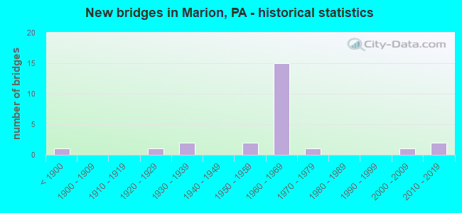
- New bridges - historical statistics
- 1Before 1900
- 11920-1929
- 21930-1939
- 21950-1959
- 151960-1969
- 11970-1979
- 12000-2009
- 22010-2019

- Reconstructed bridges - Historical Statistics
- 21960-1969
- 01970-1979
- 01980-1989
- 01990-1999
- 12000-2009
- 12010-2019


- Bridge Condition - Deck
- 23.1%Very good
- 38.5%Good
- 23.1%Satisfactory
- 7.7%Fair
- 7.7%Poor

- Bridge Condition - Superstructure
- 14.3%Very good
- 21.4%Good
- 28.6%Satisfactory
- 28.6%Fair
- 7.1%Poor

- Bridge Condition - Substructure
- 14.3%Very good
- 14.3%Good
- 35.7%Satisfactory
- 35.7%Fair

- Bridge Condition - Channel
- 60.0%Satisfactory
- 30.0%Fair
- 10.0%Poor
Find on map >> Show street view
Structure Number: 17372, Location: 0.5 ML. N.OF MARION (Lat: 39.863136, Lng: -77.684469), Route carried "on" structure: State highway , Year Built: 1963, Status: Open, Structure Length: 6.77m (22.21ft), Average Daily Traffic: 500 (year 2021), Truck Traffic: 22%, Average Future Daily Traffic: 895 (year 2032), Design Load: HS 20, Features Intersected: I-81 ; SR 0081, Facility Carried by Structure: T-452; ALLEMAN RD
Minimum Vertical Clearance: 30+ m (98+ ft), Kilometerpoint: 0.000, Lanes on structure: 2, Lanes under structure: 8, Owner: State Highway Agency, Approaching Roadway Width: 8.5m (27.9ft), Skew: 3 degrees, Material/Design: Prestressed concrete, Design/Construction: Box Beam or Girders - Multiple, Number Of Spans In Main Unit: 4, Length of Maximum Span: 22.6m (74.1ft), Curb or Sidewalk Widths: Left: 0.5m (1.6ft), Right: 0.5m (1.6ft), Curb-To-Curb Width: 8.5m (27.9ft), Out-to-Out Width: 10.2m (33.5ft)
Condition: Deck: Good, Superstructure: Satisfactory, Substructure: Satisfactory, Operating Rating: 71.7 metric tons, Method Used To Determine Operating Rating: Load Factor (LF), Inventory Rating: 28.1 metric tons, Method Used To Determine Inventory Rating: Load Factor (LF), Structural Evaluation: Equal to present minimum criteria, Deck Geometry: Somewhat better than minimum adequacy, Underclear: Superior to present desirable criteria, Approach Roadway Alignment: Equal to present desirable criteria, Length Of Structure Improvement: 7.70m (25.26ft), Designated Inspection Frequency: Every 24 months, Inspection Date: January 2020, Bridge Improvement Cost: $37,000, Roadway Improvement Cost: $110,000, Total Project Cost: $504,000, Deck Structure Type: Concrete Cast-file-Place, Wearing Surface/Protective System: Wearing Surface: Latex Concrete
Find on map >> Show street view
Structure Number: 17373, Location: 1 ML. N. OF MARION (Lat: 39.869828, Lng: -77.681047), Route carried "on" structure: State highway , Year Built: 1963, Status: Open, Structure Length: 6.34m (20.80ft), Average Daily Traffic: 551 (year 2021), Truck Traffic: 15%, Average Future Daily Traffic: 395 (year 2032), Design Load: HS 20, Features Intersected: I-81; SR 0081, Facility Carried by Structure: T-455; OVERCASH RD
Minimum Vertical Clearance: 30+ m (98+ ft), Kilometerpoint: 0.000, Lanes on structure: 2, Lanes under structure: 8, Owner: State Highway Agency, Approaching Roadway Width: 8.5m (27.9ft), Skew: 2 degrees, Material/Design: Prestressed concrete, Design/Construction: Box Beam or Girders - Multiple, Number Of Spans In Main Unit: 4, Length of Maximum Span: 20.7m (67.9ft), Curb or Sidewalk Widths: Left: 0.5m (1.6ft), Right: 0.5m (1.6ft), Curb-To-Curb Width: 8.5m (27.9ft), Out-to-Out Width: 10.2m (33.5ft)
Condition: Deck: Good, Superstructure: Good, Substructure: Good, Operating Rating: 76.2 metric tons, Method Used To Determine Operating Rating: Load Factor (LF), Inventory Rating: 32.7 metric tons, Method Used To Determine Inventory Rating: Load Factor (LF), Structural Evaluation: Better than present minimum criteria, Deck Geometry: Somewhat better than minimum adequacy, Underclear: Superior to present desirable criteria, Approach Roadway Alignment: Better than present minimum criteria, Length Of Structure Improvement: 7.30m (23.95ft), Designated Inspection Frequency: Every 24 months, Inspection Date: January 2020, Bridge Improvement Cost: $35,000, Roadway Improvement Cost: $103,000, Total Project Cost: $473,000, Deck Structure Type: Concrete Cast-file-Place, Wearing Surface/Protective System: Wearing Surface: Latex Concrete
Find on map >> Show street view
Structure Number: 17374, Location: 1.5 ML. N. OF MARION (Lat: 39.876708, Lng: -77.677189), Route carried "on" structure: State highway , Year Built: 1963, Status: Open, Structure Length: 6.77m (22.21ft), Average Daily Traffic: 102 (year 2021), Truck Traffic: 11%, Average Future Daily Traffic: 173 (year 2032), Design Load: HS 20, Features Intersected: I-81, SR 0081, Facility Carried by Structure: T-452; LIGHTHSE RD
Minimum Vertical Clearance: 30+ m (98+ ft), Kilometerpoint: 0.000, Lanes on structure: 2, Lanes under structure: 8, Owner: State Highway Agency, Approaching Roadway Width: 8.5m (27.9ft), Skew: 3 degrees, Material/Design: Prestressed concrete, Design/Construction: Box Beam or Girders - Multiple, Number Of Spans In Main Unit: 4, Length of Maximum Span: 23.2m (76.1ft), Curb or Sidewalk Widths: Left: 0.5m (1.6ft), Right: 0.5m (1.6ft), Curb-To-Curb Width: 8.5m (27.9ft), Out-to-Out Width: 10.2m (33.5ft)
Condition: Deck: Very good, Superstructure: Satisfactory, Substructure: Satisfactory, Operating Rating: 71.7 metric tons, Method Used To Determine Operating Rating: Load Factor (LF), Inventory Rating: 27.2 metric tons, Method Used To Determine Inventory Rating: Load Factor (LF), Structural Evaluation: Equal to present minimum criteria, Deck Geometry: Equal to present minimum criteria, Underclear: Meets minimum limits, Approach Roadway Alignment: Equal to present desirable criteria, Length Of Structure Improvement: 7.80m (25.59ft), Designated Inspection Frequency: Every 24 months, Inspection Date: Febuary 2020, Bridge Improvement Cost: $92,000, Roadway Improvement Cost: $270,000, Total Project Cost: $1,239,000, Deck Structure Type: Concrete Cast-file-Place, Wearing Surface/Protective System: Wearing Surface: Latex Concrete
Find on map >> Show street view
Structure Number: 17446, Location: MARION (Lat: 39.855269, Lng: -77.686933), Route carried "on" structure: State highway 914, Year Built: 1963, Status: Open, Structure Length: 6.10m (20.01ft), Average Daily Traffic: 2,276 (year 2022), Truck Traffic: 13%, Average Future Daily Traffic: 3,913 (year 2032), Design Load: HS 20, Features Intersected: I-81; SR 0081
Minimum Vertical Clearance: 30+ m (98+ ft), Kilometerpoint: 1.521, Lanes on structure: 2, Lanes under structure: 8, Owner: State Highway Agency, Approaching Roadway Width: 9.1m (29.9ft), Skew: 1 degrees, Material/Design: Prestressed concrete, Design/Construction: Box Beam or Girders - Multiple, Number Of Spans In Main Unit: 4, Length of Maximum Span: 19.8m (65.0ft), Curb or Sidewalk Widths: Left: 0.2m (0.7ft), Right: 0.2m (0.7ft), Curb-To-Curb Width: 9.2m (30.2ft), Out-to-Out Width: 10.2m (33.5ft)
Condition: Deck: Satisfactory, Superstructure: Good, Substructure: Fair, Operating Rating: 80.7 metric tons, Method Used To Determine Operating Rating: Load Factor (LF), Inventory Rating: 38.1 metric tons, Method Used To Determine Inventory Rating: Load Factor (LF), Structural Evaluation: Somewhat better than minimum adequacy, Deck Geometry: Meets minimum limits, Underclear: Superior to present desirable criteria, Approach Roadway Alignment: Equal to present desirable criteria, Length Of Structure Improvement: 7.10m (23.29ft), Designated Inspection Frequency: Every 24 months, Inspection Date: January 2020, Bridge Improvement Cost: $84,000, Roadway Improvement Cost: $247,000, Total Project Cost: $1,132,000, Wearing Surface/Protective System: Wearing Surface: Monolithic Concrete, Deck Protection: Epoxy Coated Reinforcing
Find on map >> Show street view
Structure Number: 17512, Location: 1.75 ML. S.OF MARION (Lat: 39.830336, Lng: -77.698119), Route carried "on" structure: State highway , Year Built: 1963, Year Reconstructed: 2011, Status: Open, Structure Length: 6.49m (21.29ft), Average Daily Traffic: 699 (year 2020), Truck Traffic: 6%, Average Future Daily Traffic: 894 (year 2032), Design Load: HS 20, Features Intersected: I-81;SR 0081, Facility Carried by Structure: SR 2016 clayhill
Minimum Vertical Clearance: 30+ m (98+ ft), Kilometerpoint: 3.141, Lanes on structure: 2, Lanes under structure: 8, Owner: State Highway Agency, Approaching Roadway Width: 8.8m (28.9ft), Skew: 2 degrees, Material/Design: Prestressed concrete, Design/Construction: Box Beam or Girders - Multiple, Number Of Spans In Main Unit: 4, Length of Maximum Span: 21.0m (68.9ft), Curb or Sidewalk Widths: Left: 0.2m (0.7ft), Right: 0.2m (0.7ft), Curb-To-Curb Width: 9.2m (30.2ft), Out-to-Out Width: 10.2m (33.5ft)
Condition: Deck: Good, Superstructure: Satisfactory, Substructure: Satisfactory, Operating Rating: 84.4 metric tons, Method Used To Determine Operating Rating: Load Factor (LF), Inventory Rating: 35.4 metric tons, Method Used To Determine Inventory Rating: Load Factor (LF), Structural Evaluation: Equal to present minimum criteria, Deck Geometry: Equal to present minimum criteria, Underclear: Superior to present desirable criteria, Approach Roadway Alignment: Equal to present desirable criteria, Length Of Structure Improvement: 7.40m (24.28ft), Designated Inspection Frequency: Every 24 months, Inspection Date: January 2020, Bridge Improvement Cost: $66,000, Roadway Improvement Cost: $194,000, Total Project Cost: $891,000, Deck Structure Type: Concrete Cast-file-Place, Wearing Surface/Protective System: Wearing Surface: Monolithic Concrete
Find on map >> Show street view
Structure Number: 17554, Location: .75 MI.E. OF TURKEY FOOT (Lat: 39.885106, Lng: -77.712864), Route carried "on" structure: State highway , Year Built: 1860, Status: Posted for load, Structure Length: 2.32m (7.61ft), Average Daily Traffic: 2,774 (year 2022), Truck Traffic: 6%, Average Future Daily Traffic: 3,969 (year 2032), Design Load: H 20, Features Intersected: Conococheague Creek, Facility Carried by Structure: SR3012;Social Isle
Minimum Vertical Clearance: 30+ m (98+ ft), Kilometerpoint: 8.069, Lanes on structure: 1, Owner: State Highway Agency, Approaching Roadway Width: 6.4m (21.0ft), Material/Design: Masonry, Design/Construction: Arch - Deck, Number Of Spans In Main Unit: 2, Length of Maximum Span: 10.7m (35.1ft), Curb-To-Curb Width: 4.3m (14.1ft), Out-to-Out Width: 5.6m (18.4ft)
Condition: Superstructure: Fair, Substructure: Fair, Channel: Fair, Operating Rating: 13.6 metric tons, Method Used To Determine Operating Rating: Field evaluation and documented engineering judgment, Inventory Rating: 9.1 metric tons, Method Used To Determine Inventory Rating: Field evaluation and documented engineering judgment, Structural Evaluation: High priority of replacement, Deck Geometry: High priority of replacement, Waterway Adequacy: Better than present minimum criteria, Approach Roadway Alignment: Equal to present desirable criteria, Bridge Posting: Required (Relationship of Operating Rating to Maximum Legal Load: > 39.9% below), Length Of Structure Improvement: 3.00m (9.84ft), Designated Inspection Frequency: Every 24 months, Other Special Inspection Frequency: Every 12 months, Inspection Date: April 2020, Other Special Inspection Date: April 2021, Bridge Improvement Cost: $46,000, Roadway Improvement Cost: $136,000, Total Project Cost: $624,000
Find on map >> Show street view
Structure Number: 17556, Location: 2.5 MI W OF WILLIAMSON (Lat: 39.850869, Lng: -77.757589), Route carried "on" structure: State highway , Year Built: 1930, Year Reconstructed: 1974, Status: Open, Structure Length: 4.27m (14.01ft), Average Daily Traffic: 836 (year 2022), Truck Traffic: 7%, Average Future Daily Traffic: 1,373 (year 2032), Design Load: HS 20, Features Intersected: EAST BR CONOCOCHEAQUE, Facility Carried by Structure: SR 3013 Stone Br.
Minimum Vertical Clearance: 30+ m (98+ ft), Kilometerpoint: 3.784, Lanes on structure: 2, Owner: State Highway Agency, Approaching Roadway Width: 6.7m (22.0ft), Material/Design: Masonry, Design/Construction: Arch - Deck, Number Of Spans In Main Unit: 2, Length of Maximum Span: 12.5m (41.0ft), Curb-To-Curb Width: 6.6m (21.7ft), Out-to-Out Width: 7.3m (24.0ft)
Condition: Deck: Fair, Superstructure: Fair, Substructure: Fair, Channel: Satisfactory, Operating Rating: 49.0 metric tons, Method Used To Determine Operating Rating: Field evaluation and documented engineering judgment, Inventory Rating: 32.7 metric tons, Method Used To Determine Inventory Rating: Field evaluation and documented engineering judgment, Structural Evaluation: Somewhat better than minimum adequacy, Deck Geometry: High priority of corrective action, Waterway Adequacy: Better than present minimum criteria, Approach Roadway Alignment: Somewhat better than minimum adequacy, Length Of Structure Improvement: 5.20m (17.06ft), Designated Inspection Frequency: Every 24 months, Other Special Inspection Frequency: Every 12 months, Inspection Date: April 2020, Other Special Inspection Date: April 2021, Bridge Improvement Cost: $35,000, Roadway Improvement Cost: $102,000, Total Project Cost: $469,000, Deck Structure Type: Concrete Cast-file-Place, Wearing Surface/Protective System: Wearing Surface: Monolithic Concrete
Find on map >> Show street view
Structure Number: 17559, Location: 1 Mi. SW of Marion (Lat: 39.847628, Lng: -77.733144), Route carried "on" structure: State highway , Year Built: 1954, Year Reconstructed: 2010, Status: Open, Structure Length: 3.57m (11.71ft), Average Daily Traffic: 537 (year 2022), Truck Traffic: 3%, Average Future Daily Traffic: 656 (year 2032), Design Load: HL 93, Features Intersected: Conococheague Creek, Facility Carried by Structure: SR 3015;Guitner Rd
Minimum Vertical Clearance: 30+ m (98+ ft), Kilometerpoint: 3.846, Lanes on structure: 2, Owner: State Highway Agency, Approaching Roadway Width: 6.1m (20.0ft), Material/Design: Prestressed concrete continuous, Design/Construction: Box Beam or Girders - Single/Spread, Number Of Spans In Main Unit: 3, Length of Maximum Span: 11.9m (39.0ft), Curb or Sidewalk Widths: Left: 0.2m (0.7ft), Right: 0.2m (0.7ft), Curb-To-Curb Width: 7.9m (25.9ft), Out-to-Out Width: 8.4m (27.6ft)
Condition: Deck: Good, Superstructure: Very good, Substructure: Satisfactory, Channel: Satisfactory, Operating Rating: 53.8 metric tons, Method Used To Determine Operating Rating: Assigned ratings based on Load and Resistance Factor Design (LRFD) reported by rating factor (RF) using HL93 loadings, Inventory Rating: 33.7 metric tons, Method Used To Determine Inventory Rating: Assigned ratings based on Load and Resistance Factor Design (LRFD) reported by rating factor (RF) using HL93 loadings, Structural Evaluation: Equal to present minimum criteria, Deck Geometry: Somewhat better than minimum adequacy, Waterway Adequacy: Better than present minimum criteria, Approach Roadway Alignment: Somewhat better than minimum adequacy, Designated Inspection Frequency: Every 24 months, Inspection Date: May 2020, Bridge Improvement Cost: $101,000, Roadway Improvement Cost: $297,000, Total Project Cost: $1,361,000, Deck Structure Type: Concrete Cast-file-Place, Wearing Surface/Protective System: Wearing Surface: Monolithic Concrete, Deck Protection: Epoxy Coated Reinforcing
Find on map >> Show street view
Structure Number: 17715, Location: 1 MI NW OF SR 995 (Lat: 39.876422, Lng: -77.749233), Route carried "on" structure: City street , Year Built: 1976, Status: Open, Structure Length: 3.17m (10.40ft), Average Daily Traffic: 200 (year 2009), Average Future Daily Traffic: 250 (year 2029), Design Load: HS 20, Features Intersected: BACK CREEK, Facility Carried by Structure: T458 JACK MILLS RD
Minimum Vertical Clearance: 30+ m (98+ ft), Kilometerpoint: 0.000, Lanes on structure: 2, Owner: County Highway Agency, Approaching Roadway Width: 7.3m (24.0ft), Material/Design: Prestressed concrete, Design/Construction: Box Beam or Girders - Single/Spread, Number Of Spans In Main Unit: 2, Length of Maximum Span: 15.5m (50.9ft), Curb-To-Curb Width: 6.7m (22.0ft), Out-to-Out Width: 7.7m (25.3ft)
Condition: Deck: Good, Superstructure: Fair, Substructure: Fair, Channel: Fair, Operating Rating: 66.2 metric tons, Method Used To Determine Operating Rating: Load Factor (LF), Inventory Rating: 33.6 metric tons, Method Used To Determine Inventory Rating: Load Factor (LF), Structural Evaluation: Somewhat better than minimum adequacy, Deck Geometry: Meets minimum limits, Waterway Adequacy: Better than present minimum criteria, Approach Roadway Alignment: Somewhat better than minimum adequacy, Length Of Structure Improvement: 4.80m (15.75ft), Designated Inspection Frequency: Every 24 months, Inspection Date: October 2019, Deck Structure Type: Concrete Cast-file-Place, Wearing Surface/Protective System: Wearing Surface: Latex Concrete
Find on map >> Show street view
Structure Number: 17716, Location: 0.7 MI SOUTH OF SR 30 (Lat: 39.916394, Lng: -77.748253), Route carried "on" structure: City street , Year Built: 1930, Year Reconstructed: 1972, Status: Open, Structure Length: 1.31m (4.30ft), Average Daily Traffic: 1,100 (year 2009), Average Future Daily Traffic: 1,540 (year 2029), Features Intersected: BACK CREEK TRIB, Facility Carried by Structure: HADE RD
Minimum Vertical Clearance: 30+ m (98+ ft), Kilometerpoint: 0.000, Lanes on structure: 2, Owner: County Highway Agency, Approaching Roadway Width: 7.9m (25.9ft), Skew: 3 degrees, Material/Design: Concrete, Design/Construction: Box Beam or Girders - Multiple, Number Of Spans In Main Unit: 1, Length of Maximum Span: 11.6m (38.1ft), Curb or Sidewalk Widths: Left: 0.2m (0.7ft), Right: 0.2m (0.7ft), Curb-To-Curb Width: 8.8m (28.9ft), Out-to-Out Width: 10.1m (33.1ft)
Condition: Deck: Satisfactory, Superstructure: Fair, Substructure: Satisfactory, Channel: Satisfactory, Operating Rating: 49.0 metric tons, Method Used To Determine Operating Rating: Field evaluation and documented engineering judgment, Inventory Rating: 32.7 metric tons, Method Used To Determine Inventory Rating: Field evaluation and documented engineering judgment, Structural Evaluation: Somewhat better than minimum adequacy, Deck Geometry: Somewhat better than minimum adequacy, Waterway Adequacy: Equal to present desirable criteria, Approach Roadway Alignment: Equal to present desirable criteria, Length Of Structure Improvement: 2.00m (6.56ft), Designated Inspection Frequency: Every 24 months, Inspection Date: October 2019, Deck Structure Type: Concrete Cast-file-Place, Wearing Surface/Protective System: Wearing Surface: Bituminous
Find on map >> Show street view
Structure Number: 17718, Location: 1.5 MI EAST OF SR 3013 (Lat: 39.873161, Lng: -77.762289), Route carried "on" structure: City street , Year Built: 1929, Status: Open, Structure Length: 0.91m (2.99ft), Average Daily Traffic: 250 (year 2009), Average Future Daily Traffic: 320 (year 2029), Design Load: HS 20, Features Intersected: BACK CREEK TRIB, Facility Carried by Structure: T-459 GRAPEVINE RD
Minimum Vertical Clearance: 30+ m (98+ ft), Kilometerpoint: 0.000, Lanes on structure: 1, Owner: County Highway Agency, Approaching Roadway Width: 6.1m (20.0ft), Material/Design: Steel, Design/Construction: Stringer/Multi-beam, Number Of Spans In Main Unit: 1, Length of Maximum Span: 8.5m (27.9ft), Curb-To-Curb Width: 5.2m (17.1ft), Out-to-Out Width: 6.2m (20.3ft)
Condition: Deck: Satisfactory, Superstructure: Satisfactory, Substructure: Good, Channel: Poor, Operating Rating: 88.0 metric tons, Method Used To Determine Operating Rating: Load Factor (LF), Inventory Rating: 52.6 metric tons, Method Used To Determine Inventory Rating: Load Factor (LF), Structural Evaluation: Equal to present minimum criteria, Deck Geometry: High priority of replacement, Waterway Adequacy: Better than present minimum criteria, Approach Roadway Alignment: Meets minimum limits, Length Of Structure Improvement: 1.60m (5.25ft), Designated Inspection Frequency: Every 24 months, Inspection Date: October 2019, Bridge Improvement Cost: $14,000, Roadway Improvement Cost: $40,000, Total Project Cost: $184,000, Deck Structure Type: Concrete Cast-file-Place, Wearing Surface/Protective System: Wearing Surface: Bituminous
Find on map >> Show street view
Structure Number: 17727, Location: 2 MI WEST OF SR 995 (Lat: 39.919353, Lng: -77.742531), Route carried "on" structure: City street , Year Built: 1959, Status: Posted for load, Structure Length: 2.74m (8.99ft), Average Daily Traffic: 600 (year 2009), Average Future Daily Traffic: 775 (year 2029), Design Load: HS 20, Features Intersected: BACK CREEK, Facility Carried by Structure: LEAFMORE RD
Minimum Vertical Clearance: 30+ m (98+ ft), Kilometerpoint: 0.000, Lanes on structure: 2, Owner: County Highway Agency, Approaching Roadway Width: 6.7m (22.0ft), Material/Design: Prestressed concrete, Design/Construction: Box Beam or Girders - Multiple, Number Of Spans In Main Unit: 2, Length of Maximum Span: 13.1m (43.0ft), Curb-To-Curb Width: 6.8m (22.3ft), Out-to-Out Width: 7.6m (24.9ft)
Condition: Deck: Poor, Superstructure: Poor, Substructure: Fair, Channel: Fair, Operating Rating: 35.4 metric tons, Method Used To Determine Operating Rating: Load Factor (LF), Inventory Rating: 19.1 metric tons, Method Used To Determine Inventory Rating: Load Factor (LF), Structural Evaluation: Meets minimum limits, Deck Geometry: Meets minimum limits, Waterway Adequacy: Equal to present minimum criteria, Approach Roadway Alignment: Equal to present desirable criteria, Bridge Posting: Required (Relationship of Operating Rating to Maximum Legal Load: 10.0 - 19.9% below), Length Of Structure Improvement: 3.50m (11.48ft), Designated Inspection Frequency: Every 24 months, Other Special Inspection Frequency: Every 12 months, Inspection Date: October 2019, Other Special Inspection Date: October 2020, Deck Structure Type: Other, Wearing Surface/Protective System: Wearing Surface: Bituminous
Find on map >> Show street view
Structure Number: 43101, Location: BROWNS MILL (Lat: 39.828994, Lng: -77.701364), Route carried "on" structure: State highway , Year Built: 2005, Status: Open, Structure Length: 0.79m (2.59ft), Average Daily Traffic: 512 (year 2020), Truck Traffic: 8%, Average Future Daily Traffic: 837 (year 2032), Design Load: HS 20, Features Intersected: BR MUDDY RUN CREEK, Facility Carried by Structure: SR2001 Brown's mil
Minimum Vertical Clearance: 30+ m (98+ ft), Kilometerpoint: 6.777, Lanes on structure: 2, Owner: State Highway Agency, Approaching Roadway Width: 8.5m (27.9ft), Material/Design: Concrete, Design/Construction: Culvert, Number Of Spans In Main Unit: 1, Length of Maximum Span: 7.3m (24.0ft), Curb-To-Curb Width: 8.5m (27.9ft), Out-to-Out Width: 8.5m (27.9ft)
Condition: Channel: Satisfactory, Culverts: Good, Operating Rating: 79.8 metric tons, Method Used To Determine Operating Rating: Load Factor (LF), Inventory Rating: 48.1 metric tons, Method Used To Determine Inventory Rating: Load Factor (LF), Structural Evaluation: Better than present minimum criteria, Deck Geometry: Somewhat better than minimum adequacy, Waterway Adequacy: Better than present minimum criteria, Approach Roadway Alignment: Equal to present desirable criteria, Length Of Structure Improvement: 1.40m (4.59ft), Designated Inspection Frequency: Every 24 months, Inspection Date: December 2019, Wearing Surface/Protective System: Wearing Surface: Bituminous, Membrane: Preformed Fabric
Find on map >> Show street view
Structure Number: 46789, Location: 4 Mi. SE of St. Thomas (Lat: 39.893150, Lng: -77.741756), Route carried "on" structure: State highway , Year Built: 2011, Status: Open, Structure Length: 3.87m (12.70ft), Average Daily Traffic: 1,665 (year 2020), Truck Traffic: 10%, Average Future Daily Traffic: 1,803 (year 2032), Design Load: HL 93, Features Intersected: Back Creek, Facility Carried by Structure: SR 3012;Jack Rd.
Minimum Vertical Clearance: 30+ m (98+ ft), Kilometerpoint: 5.446, Lanes on structure: 2, Owner: State Highway Agency, Approaching Roadway Width: 6.1m (20.0ft), Skew: 2 degrees, Material/Design: Prestressed concrete, Design/Construction: Stringer/Multi-beam, Number Of Spans In Main Unit: 2, Length of Maximum Span: 18.9m (62.0ft), Curb or Sidewalk Widths: Left: 0.2m (0.7ft), Right: 0.2m (0.7ft), Curb-To-Curb Width: 9.8m (32.2ft), Out-to-Out Width: 10.8m (35.4ft)
Condition: Deck: Very good, Superstructure: Good, Substructure: Very good, Channel: Satisfactory, Operating Rating: 61.2 metric tons, Method Used To Determine Operating Rating: Assigned ratings based on Load and Resistance Factor Design (LRFD) reported by rating factor (RF) using HL93 loadings, Inventory Rating: 38.6 metric tons, Method Used To Determine Inventory Rating: Assigned ratings based on Load and Resistance Factor Design (LRFD) reported by rating factor (RF) using HL93 loadings, Structural Evaluation: Better than present minimum criteria, Deck Geometry: Somewhat better than minimum adequacy, Waterway Adequacy: Equal to present desirable criteria, Approach Roadway Alignment: Better than present minimum criteria, Designated Inspection Frequency: Every 24 months, Inspection Date: May 2020, Deck Structure Type: Concrete Cast-file-Place, Wearing Surface/Protective System: Wearing Surface: Monolithic Concrete, Deck Protection: Epoxy Coated Reinforcing
Find on map >> Show street view
Structure Number: 4679, Location: 3.5 MI S. OF ST. THOMAS (Lat: 39.873189, Lng: -77.773631), Route carried "on" structure: State highway , Year Built: 2011, Status: Open, Structure Length: 6.04m (19.82ft), Average Daily Traffic: 820 (year 2022), Truck Traffic: 7%, Average Future Daily Traffic: 734 (year 2032), Design Load: HL 93, Features Intersected: BACK CREEK, Facility Carried by Structure: SR 3013
Minimum Vertical Clearance: 30+ m (98+ ft), Kilometerpoint: 6.650, Lanes on structure: 2, Owner: State Highway Agency, Approaching Roadway Width: 8.5m (27.9ft), Skew: 3 degrees, Material/Design: Prestressed concrete, Design/Construction: Stringer/Multi-beam, Number Of Spans In Main Unit: 3, Length of Maximum Span: 19.5m (64.0ft), Curb or Sidewalk Widths: Left: 0.2m (0.7ft), Right: 0.2m (0.7ft), Curb-To-Curb Width: 8.5m (27.9ft), Out-to-Out Width: 9.6m (31.5ft)
Condition: Deck: Very good, Superstructure: Very good, Substructure: Very good, Channel: Satisfactory, Operating Rating: 58.3 metric tons, Method Used To Determine Operating Rating: Assigned ratings based on Load and Resistance Factor Design (LRFD) reported by rating factor (RF) using HL93 loadings, Inventory Rating: 36.6 metric tons, Method Used To Determine Inventory Rating: Assigned ratings based on Load and Resistance Factor Design (LRFD) reported by rating factor (RF) using HL93 loadings, Structural Evaluation: Equal to present desirable criteria, Deck Geometry: Somewhat better than minimum adequacy, Waterway Adequacy: Equal to present desirable criteria, Approach Roadway Alignment: Equal to present desirable criteria, Designated Inspection Frequency: Every 24 months, Inspection Date: January 2020, Deck Structure Type: Concrete Cast-file-Place, Wearing Surface/Protective System: Wearing Surface: Monolithic Concrete, Deck Protection: Epoxy Coated Reinforcing
Find on map >> Show street view
Structure Number: 17372, Location: 0.5 ML. N.OF MARION (Lat: 39.863136, Lng: -77.684469), Route carried "under" structure: Interstate 81, Year Built: 1963, Structure Length: 0. m, Average Daily Traffic: 29,266 (year 2021), Truck Traffic: 43%, Features Intersected: I-81 ; SR 0081, Facility Carried by Structure: T-452; ALLEMAN RD
Minimum Vertical Clearance: 5.41m (17.75ft), Kilometerpoint: 16.098, Lanes on structure: 2, Lanes under structure: 4, Material/Design: Prestressed concrete, Design/Construction: Box Beam or Girders - Multiple, Length of Maximum Span: 22.6m (74.1ft)
Find on map >> Show street view
Structure Number: 17372, Location: 0.5 ML. N.OF MARION (Lat: 39.863136, Lng: -77.684469), Route carried "under" structure: Interstate 81, Year Built: 1963, Structure Length: 0. m, Average Daily Traffic: 27,746 (year 2021), Truck Traffic: 45%, Features Intersected: I-81 ; SR 0081, Facility Carried by Structure: T-452; ALLEMAN RD
Minimum Vertical Clearance: 5.41m (17.75ft), Kilometerpoint: 16.085, Lanes on structure: 2, Lanes under structure: 4, Material/Design: Prestressed concrete, Design/Construction: Box Beam or Girders - Multiple, Length of Maximum Span: 22.6m (74.1ft)
Find on map >> Show street view
Structure Number: 17373, Location: 1 ML. N. OF MARION (Lat: 39.869828, Lng: -77.681047), Route carried "under" structure: Interstate 81, Year Built: 1963, Structure Length: 0. m, Average Daily Traffic: 29,266 (year 2021), Truck Traffic: 43%, Features Intersected: I-81; SR 0081, Facility Carried by Structure: T-455; OVERCASH RD
Minimum Vertical Clearance: 5.23m (17.16ft), Kilometerpoint: 16.908, Lanes on structure: 2, Lanes under structure: 4, Material/Design: Prestressed concrete, Design/Construction: Box Beam or Girders - Multiple, Length of Maximum Span: 20.7m (67.9ft)
Find on map >> Show street view
Structure Number: 17373, Location: 1 ML. N. OF MARION (Lat: 39.869828, Lng: -77.681047), Route carried "under" structure: Interstate 81, Year Built: 1963, Structure Length: 0. m, Average Daily Traffic: 27,746 (year 2021), Truck Traffic: 45%, Features Intersected: I-81; SR 0081, Facility Carried by Structure: T-455; OVERCASH RD
Minimum Vertical Clearance: 5.23m (17.16ft), Kilometerpoint: 16.897, Lanes on structure: 2, Lanes under structure: 4, Material/Design: Prestressed concrete, Design/Construction: Box Beam or Girders - Multiple, Length of Maximum Span: 20.7m (67.9ft)
Find on map >> Show street view
Structure Number: 17374, Location: 1.5 ML. N. OF MARION (Lat: 39.876708, Lng: -77.677189), Route carried "under" structure: Interstate 81, Year Built: 1963, Structure Length: 0. m, Average Daily Traffic: 29,266 (year 2021), Truck Traffic: 43%, Features Intersected: I-81, SR 0081, Facility Carried by Structure: T-452; LIGHTHSE RD
Minimum Vertical Clearance: 5.23m (17.16ft), Kilometerpoint: 17.709, Lanes on structure: 2, Lanes under structure: 4, Material/Design: Prestressed concrete, Design/Construction: Box Beam or Girders - Multiple, Length of Maximum Span: 23.2m (76.1ft)
Find on map >> Show street view
Structure Number: 17374, Location: 1.5 ML. N. OF MARION (Lat: 39.876708, Lng: -77.677189), Route carried "under" structure: Interstate 81, Year Built: 1963, Structure Length: 0. m, Average Daily Traffic: 27,746 (year 2021), Truck Traffic: 45%, Features Intersected: I-81, SR 0081, Facility Carried by Structure: T-452; LIGHTHSE RD
Minimum Vertical Clearance: 5.23m (17.16ft), Kilometerpoint: 17.700, Lanes on structure: 2, Lanes under structure: 4, Material/Design: Prestressed concrete, Design/Construction: Box Beam or Girders - Multiple, Length of Maximum Span: 23.2m (76.1ft)
Find on map >> Show street view
Structure Number: 17446, Location: MARION (Lat: 39.855269, Lng: -77.686933), Route carried "under" structure: Interstate 81, Year Built: 1963, Structure Length: 0. m, Average Daily Traffic: 29,266 (year 2021), Truck Traffic: 43%, Features Intersected: I-81; SR 0081, Facility Carried by Structure: PA 914; Swamp Fox
Minimum Vertical Clearance: 5.23m (17.16ft), Kilometerpoint: 15.334, Lanes on structure: 2, Lanes under structure: 4, Material/Design: Prestressed concrete, Design/Construction: Box Beam or Girders - Multiple, Length of Maximum Span: 19.8m (65.0ft)
Find on map >> Show street view
Structure Number: 17446, Location: MARION (Lat: 39.855269, Lng: -77.686933), Route carried "under" structure: Interstate 81, Year Built: 1963, Structure Length: 0. m, Average Daily Traffic: 27,746 (year 2021), Truck Traffic: 45%, Features Intersected: I-81; SR 0081, Facility Carried by Structure: PA 914; Swamp Fox
Minimum Vertical Clearance: 5.23m (17.16ft), Kilometerpoint: 15.348, Lanes on structure: 2, Lanes under structure: 4, Material/Design: Prestressed concrete, Design/Construction: Box Beam or Girders - Multiple, Length of Maximum Span: 19.8m (65.0ft)
Find on map >> Show street view
Structure Number: 17512, Location: 1.75 ML. S.OF MARION (Lat: 39.830336, Lng: -77.698119), Route carried "under" structure: Interstate 81, Year Built: 1963, Structure Length: 0. m, Average Daily Traffic: 23,181 (year 2021), Truck Traffic: 36%, Features Intersected: I-81;SR 0081, Facility Carried by Structure: SR 2016 clayhill
Minimum Vertical Clearance: 5.33m (17.49ft), Kilometerpoint: 12.085, Lanes on structure: 2, Lanes under structure: 4, Material/Design: Prestressed concrete, Design/Construction: Box Beam or Girders - Multiple, Length of Maximum Span: 21.0m (68.9ft)
Find on map >> Show street view
Structure Number: 17512, Location: 1.75 ML. S.OF MARION (Lat: 39.830336, Lng: -77.698119), Route carried "under" structure: Interstate 81, Year Built: 1963, Structure Length: 0. m, Average Daily Traffic: 23,500 (year 2021), Truck Traffic: 34%, Features Intersected: I-81;SR 0081, Facility Carried by Structure: SR 2016 clayhill
Minimum Vertical Clearance: 5.33m (17.49ft), Kilometerpoint: 12.107, Lanes on structure: 2, Lanes under structure: 4, Material/Design: Prestressed concrete, Design/Construction: Box Beam or Girders - Multiple, Length of Maximum Span: 21.0m (68.9ft)