Bridge Statistics for Marion, Arkansas (AR)
Condition, Traffic, Stress, Structural Evaluation, Project Costs
- National Bridge Inventory (NBI) Statistics
- 36Number of bridges
- 423ft / 129mTotal length
- $4,654,000Total costs
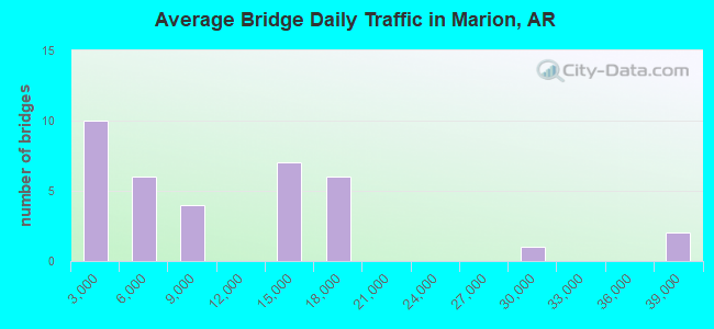
- 364,062Total average daily traffic
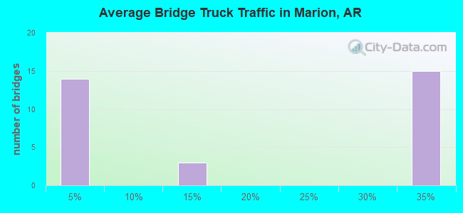
- 85,977Total average daily truck traffic
- National Bridge Inventory (NBI) Registered Bridges for Marion
- No street view available for this location
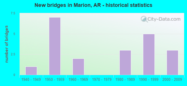
- New bridges - historical statistics
- 11940-1949
- 71950-1959
- 21960-1969
- 31980-1989
- 51990-1999
- 32000-2009
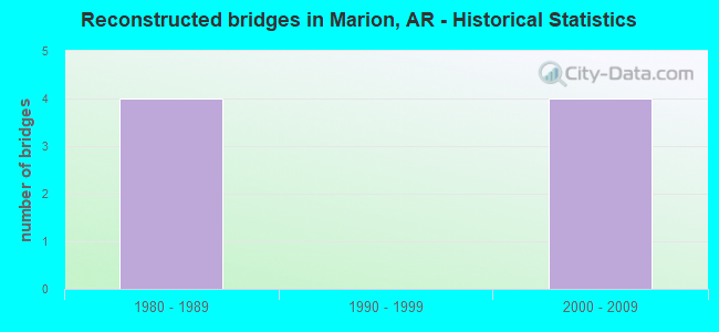
- Reconstructed bridges - Historical Statistics
- 41980-1989
- 01990-1999
- 42000-2009
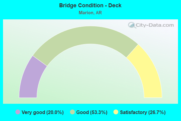
- Bridge Condition - Deck
- 20.0%Very good
- 53.3%Good
- 26.7%Satisfactory
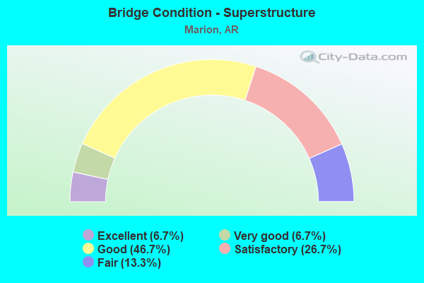
- Bridge Condition - Superstructure
- 6.7%Excellent
- 6.7%Very good
- 46.7%Good
- 26.7%Satisfactory
- 13.3%Fair
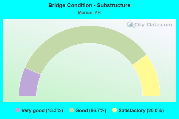
- Bridge Condition - Substructure
- 13.3%Very good
- 66.7%Good
- 20.0%Satisfactory
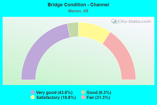
- Bridge Condition - Channel
- 43.8%Very good
- 6.3%Good
- 18.8%Satisfactory
- 31.3%Fair
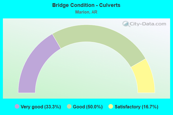
- Bridge Condition - Culverts
- 33.3%Very good
- 50.0%Good
- 16.7%Satisfactory
Find on map >> Show street view
Structure Number: 2374, Location: .10 Miles West Of I 55 (Lat: 35.211678, Lng: -90.208378), Route carried "on" structure: US 64, Year Built: 1946, Status: Open, Structure Length: 0.67m (2.20ft), Average Daily Traffic: 13,000 (year 2019), Truck Traffic: 11%, Average Future Daily Traffic: 16,200 (year 2038), Features Intersected: Drainage Ditch
Minimum Vertical Clearance: 30+ m (98+ ft), Kilometerpoint: 30.690, Lanes on structure: 6, Owner: State Highway Agency, Approaching Roadway Width: 12.2m (40.0ft), Material/Design: Concrete, Design/Construction: Culvert, Number Of Spans In Main Unit: 2, Length of Maximum Span: 3.4m (11.2ft)
Condition: Channel: Fair, Culverts: Satisfactory, Operating Rating: 29.9 metric tons, Method Used To Determine Operating Rating: Load Factor (LF), Inventory Rating: 18.1 metric tons, Method Used To Determine Inventory Rating: Load Factor (LF), Structural Evaluation: Meets minimum limits, Waterway Adequacy: Equal to present desirable criteria, Approach Roadway Alignment: Equal to present desirable criteria, Designated Inspection Frequency: Every 24 months, Critical Feature Inspection Frequency: Every 24 months, Inspection Date: September 2020
Find on map >> Show street view
Structure Number: 2671, Location: .30 MI N JCT OF I-40 (Lat: 35.180639, Lng: -90.195600), Route carried "on" structure: Interstate 55, Year Built: 1951, Year Reconstructed: 1988, Status: Open, Structure Length: 29.02m (95.21ft), Average Daily Traffic: 37,000 (year 2018), Truck Traffic: 34%, Average Future Daily Traffic: 19,100 (year 2029), Design Load: HS 20+Mod, Features Intersected: FLETCHER RD/I55 FR/BN RR
Minimum Vertical Clearance: 30+ m (98+ ft), Kilometerpoint: 12.695, Lanes on structure: 3, Lanes under structure: 2, Owner: State Highway Agency, Approaching Roadway Width: 17.1m (56.1ft), Material/Design: Steel continuous, Design/Construction: Stringer/Multi-beam, Number Of Spans In Main Unit: 21, Length of Maximum Span: 17.4m (57.1ft), Curb-To-Curb Width: 16.9m (55.4ft), Out-to-Out Width: 17.8m (58.4ft)
Condition: Deck: Satisfactory, Superstructure: Fair, Substructure: Satisfactory, Operating Rating: 54.4 metric tons, Method Used To Determine Operating Rating: Load Factor (LF), Inventory Rating: 32.7 metric tons, Method Used To Determine Inventory Rating: Load Factor (LF), Structural Evaluation: Somewhat better than minimum adequacy, Deck Geometry: Equal to present minimum criteria, Underclear: High priority of corrective action, Approach Roadway Alignment: Equal to present desirable criteria, Designated Inspection Frequency: Every 24 months, Critical Feature Inspection Frequency: Every 24 months, Inspection Date: June 2021, Deck Structure Type: Concrete Cast-file-Place, Wearing Surface/Protective System: Wearing Surface: Monolithic Concrete
Find on map >> Show street view
Structure Number: 2808, Location: 2.50 Mi N Of Marion Ark (Lat: 35.247158, Lng: -90.219569), Route carried "on" structure: Interstate 55, Year Built: 1956, Year Reconstructed: 2014, Status: Open, Structure Length: 2.47m (8.10ft), Average Daily Traffic: 29,000 (year 2018), Truck Traffic: 34%, Average Future Daily Traffic: 17,922 (year 2028), Design Load: HS 20+Mod, Features Intersected: 15 Mile Bayou
Minimum Vertical Clearance: 30+ m (98+ ft), Kilometerpoint: 20.390, Lanes on structure: 2, Base Highway Network: Yes, Owner: State Highway Agency, Approaching Roadway Width: 11.6m (38.1ft), Skew: 2 degrees, Material/Design: Concrete continuous, Design/Construction: Slab, Number Of Spans In Main Unit: 3, Length of Maximum Span: 8.8m (28.9ft), Curb or Sidewalk Widths: Left: 0.2m (0.7ft), Right: 0.2m (0.7ft), Curb-To-Curb Width: 12.1m (39.7ft), Out-to-Out Width: 13.0m (42.7ft)
Condition: Deck: Good, Superstructure: Good, Substructure: Good, Channel: Very good, Operating Rating: 54.4 metric tons, Method Used To Determine Operating Rating: Load Factor (LF), Inventory Rating: 32.7 metric tons, Method Used To Determine Inventory Rating: Load Factor (LF), Structural Evaluation: Better than present minimum criteria, Deck Geometry: Equal to present minimum criteria, Waterway Adequacy: Equal to present desirable criteria, Approach Roadway Alignment: Equal to present desirable criteria, Designated Inspection Frequency: Every 24 months, Critical Feature Inspection Frequency: Every 24 months, Inspection Date: April 2020, Deck Structure Type: Concrete Cast-file-Place, Wearing Surface/Protective System: Wearing Surface: Latex Concrete
Find on map >> Show street view
Structure Number: 3135, Location: 3.32 Mi South Of Sh 50 Op (Lat: 35.263111, Lng: -90.228719), Route carried "on" structure: County highway 4, Year Built: 1958, Year Reconstructed: 1980, Status: Open, Structure Length: 10.44m (34.25ft), Average Daily Traffic: 890 (year 2018), Truck Traffic: 1%, Average Future Daily Traffic: 194 (year 2007), Design Load: H 20, Features Intersected: I-55/Sec-11/L13.79, Facility Carried by Structure: Cr-James Mill/Z-F
Minimum Vertical Clearance: 30+ m (98+ ft), Kilometerpoint: 22.193, Lanes on structure: 2, Lanes under structure: 8, Owner: State Highway Agency, Approaching Roadway Width: 9.1m (29.9ft), Skew: 2 degrees, Material/Design: Steel, Design/Construction: Stringer/Multi-beam, Number Of Spans In Main Unit: 6, Length of Maximum Span: 19.8m (65.0ft), Curb-To-Curb Width: 7.6m (24.9ft), Out-to-Out Width: 8.4m (27.6ft)
Condition: Deck: Good, Superstructure: Good, Substructure: Good, Operating Rating: 54.4 metric tons, Method Used To Determine Operating Rating: Load Factor (LF), Inventory Rating: 32.7 metric tons, Method Used To Determine Inventory Rating: Load Factor (LF), Structural Evaluation: Better than present minimum criteria, Deck Geometry: Meets minimum limits, Underclear: High priority of corrective action, Approach Roadway Alignment: Equal to present desirable criteria, Designated Inspection Frequency: Every 24 months, Critical Feature Inspection Frequency: Every 24 months, Inspection Date: Febuary 2022, Deck Structure Type: Concrete Cast-file-Place, Wearing Surface/Protective System: Wearing Surface: Integral Concrete
Find on map >> Show street view
Structure Number: 4578, Location: 2.6 Mile Norh Int 27&I-40 (Lat: 35.189269, Lng: -90.136750), Route carried "on" structure: County highway 27, Year Built: 1987, Status: Open, Structure Length: 2.83m (9.28ft), Average Daily Traffic: 3,300 (year 2019), Truck Traffic: 1%, Average Future Daily Traffic: 502 (year 2007), Design Load: HS 20, Features Intersected: Ten Mile Bayou, Facility Carried by Structure: Mound City/Z-Ds
Minimum Vertical Clearance: 30+ m (98+ ft), Kilometerpoint: 4.281, Lanes on structure: 2, Owner: County Highway Agency, Approaching Roadway Width: 7.5m (24.6ft), Material/Design: Concrete, Design/Construction: Channel Beam, Number Of Spans In Main Unit: 3, Length of Maximum Span: 9.4m (30.8ft), Curb-To-Curb Width: 8.5m (27.9ft), Out-to-Out Width: 9.3m (30.5ft)
Condition: Deck: Good, Superstructure: Good, Substructure: Satisfactory, Channel: Satisfactory, Operating Rating: 54.4 metric tons, Method Used To Determine Operating Rating: Load Factor (LF), Inventory Rating: 32.7 metric tons, Method Used To Determine Inventory Rating: Load Factor (LF), Structural Evaluation: Equal to present minimum criteria, Deck Geometry: Meets minimum limits, Waterway Adequacy: Equal to present desirable criteria, Approach Roadway Alignment: Better than present minimum criteria, Designated Inspection Frequency: Every 24 months, Critical Feature Inspection Frequency: Every 24 months, Inspection Date: May 2021, Deck Structure Type: Concrete Precast Panels, Wearing Surface/Protective System: Wearing Surface: Bituminous
Find on map >> Show street view
Structure Number: 7001, Location: 2.4 Miles West Of I-55 (Lat: 35.199597, Lng: -90.245681), Route carried "on" structure: US 64, Year Built: 2007, Status: Open, Structure Length: 4.55m (14.93ft), Average Daily Traffic: 7,251 (year 2018), Truck Traffic: 14%, Average Future Daily Traffic: 8,899 (year 2028), Design Load: HS 20, Features Intersected: Fifteen Mile Bayou
Minimum Vertical Clearance: 30+ m (98+ ft), Kilometerpoint: 27.037, Lanes on structure: 5, Base Highway Network: Yes, Owner: State Highway Agency, Approaching Roadway Width: 22.9m (75.1ft), Skew: 11 degrees, Material/Design: Steel continuous, Design/Construction: Stringer/Multi-beam, Number Of Spans In Main Unit: 3, Length of Maximum Span: 16.8m (55.1ft), Curb-To-Curb Width: 22.9m (75.1ft), Out-to-Out Width: 23.8m (78.1ft)
Condition: Deck: Very good, Superstructure: Excellent, Substructure: Good, Channel: Very good, Operating Rating: 54.4 metric tons, Method Used To Determine Operating Rating: Load Factor (LF), Inventory Rating: 32.7 metric tons, Method Used To Determine Inventory Rating: Load Factor (LF), Structural Evaluation: Better than present minimum criteria, Deck Geometry: Equal to present minimum criteria, Waterway Adequacy: Superior to present desirable criteria, Approach Roadway Alignment: Equal to present desirable criteria, Designated Inspection Frequency: Every 24 months, Critical Feature Inspection Frequency: Every 24 months, Inspection Date: April 2020, Deck Structure Type: Concrete Cast-file-Place, Wearing Surface/Protective System: Wearing Surface: Monolithic Concrete, Deck Protection: Epoxy Coated Reinforcing
Find on map >> Show street view
Structure Number: 21473, Location: .01 Miles North Int Us 64 (Lat: 35.199303, Lng: -90.254958), Route carried "on" structure: County highway 5, Year Built: 1983, Year Reconstructed: 1994, Status: Posted for load, Structure Length: 2.71m (8.89ft), Average Daily Traffic: 40 (year 2018), Truck Traffic: 1%, Average Future Daily Traffic: 637 (year 2007), Features Intersected: Ditch Number 9, Facility Carried by Structure: Roseboro/Z Fe/8.10
Minimum Vertical Clearance: 30+ m (98+ ft), Kilometerpoint: 13.036, Lanes on structure: 1, Owner: County Highway Agency, Approaching Roadway Width: 6.4m (21.0ft), Material/Design: Steel, Design/Construction: Orthotropic, Number Of Spans In Main Unit: 1, Length of Maximum Span: 23.5m (77.1ft), Curb-To-Curb Width: 6.0m (19.7ft), Out-to-Out Width: 6.0m (19.7ft)
Condition: Deck: Satisfactory, Superstructure: Satisfactory, Substructure: Good, Channel: Very good, Operating Rating: 21.8 metric tons, Method Used To Determine Operating Rating: Load Factor (LF), Inventory Rating: 12.7 metric tons, Method Used To Determine Inventory Rating: Load Factor (LF), Structural Evaluation: Meets minimum limits, Deck Geometry: Meets minimum limits, Waterway Adequacy: Equal to present minimum criteria, Approach Roadway Alignment: Better than present minimum criteria, Bridge Posting: Required (Relationship of Operating Rating to Maximum Legal Load: > 39.9% below), Designated Inspection Frequency: Every 24 months, Critical Feature Inspection Frequency: Every 24 months, Inspection Date: May 2021, Critical Feature Inspection Date: May 2021, Deck Structure Type: Steel plate, Wearing Surface/Protective System: Wearing Surface: Other
Find on map >> Show street view
Structure Number: 22759, Location: 10.93 Mi East Jct Sh 77 (Lat: 35.219000, Lng: -90.166175), Route carried "on" structure: County highway 2, Year Built: 2005, Status: Posted for load, Structure Length: 2.71m (8.89ft), Average Daily Traffic: 3,585 (year 2018), Truck Traffic: 1%, Average Future Daily Traffic: 126 (year 2007), Features Intersected: Ditch Number 5, Facility Carried by Structure: Marion Lake/Z-Ds
Minimum Vertical Clearance: 30+ m (98+ ft), Kilometerpoint: 17.590, Lanes on structure: 1, Owner: County Highway Agency, Approaching Roadway Width: 7.3m (24.0ft), Material/Design: Steel, Design/Construction: Orthotropic, Number Of Spans In Main Unit: 1, Length of Maximum Span: 23.9m (78.4ft), Curb or Sidewalk Widths: Left: 0.1m (0.3ft), Right: 0.1m (0.3ft), Curb-To-Curb Width: 7.3m (24.0ft), Out-to-Out Width: 7.5m (24.6ft)
Condition: Deck: Good, Superstructure: Good, Substructure: Good, Channel: Good, Operating Rating: 23.6 metric tons, Method Used To Determine Operating Rating: Load Factor (LF), Inventory Rating: 13.6 metric tons, Method Used To Determine Inventory Rating: Load Factor (LF), Structural Evaluation: Meets minimum limits, Deck Geometry: High priority of replacement, Waterway Adequacy: Equal to present desirable criteria, Approach Roadway Alignment: Better than present minimum criteria, Bridge Posting: Required (Relationship of Operating Rating to Maximum Legal Load: 30.0 - 39.9% below), Designated Inspection Frequency: Every 24 months, Critical Feature Inspection Frequency: Every 24 months, Inspection Date: May 2021, Critical Feature Inspection Date: May 2021, Deck Structure Type: Steel plate, Wearing Surface/Protective System: Wearing Surface: Bituminous
Find on map >> Show street view
Structure Number: 22883, Location: 2.14 Miles NO I-55 (Lat: 35.182850, Lng: -90.175511), Route carried "on" structure: County highway 49, Year Built: 2009, Status: Posted for load, Structure Length: 1.83m (6.00ft), Average Daily Traffic: 20 (year 2018), Truck Traffic: 1%, Average Future Daily Traffic: 90 (year 2007), Features Intersected: Ditch, Facility Carried by Structure: Bills Gril/Z-Ds
Minimum Vertical Clearance: 30+ m (98+ ft), Kilometerpoint: 3.444, Lanes on structure: 1, Owner: County Highway Agency, Approaching Roadway Width: 5.9m (19.4ft), Material/Design: Steel, Design/Construction: Orthotropic, Number Of Spans In Main Unit: 1, Length of Maximum Span: 16.6m (54.5ft), Curb-To-Curb Width: 5.8m (19.0ft), Out-to-Out Width: 5.8m (19.0ft)
Condition: Deck: Satisfactory, Superstructure: Satisfactory, Substructure: Very good, Channel: Satisfactory, Operating Rating: 21.8 metric tons, Method Used To Determine Operating Rating: Load Factor (LF), Inventory Rating: 13.6 metric tons, Method Used To Determine Inventory Rating: Load Factor (LF), Structural Evaluation: Meets minimum limits, Deck Geometry: Meets minimum limits, Waterway Adequacy: Equal to present desirable criteria, Approach Roadway Alignment: Equal to present desirable criteria, Bridge Posting: Required (Relationship of Operating Rating to Maximum Legal Load: > 39.9% below), Designated Inspection Frequency: Every 24 months, Critical Feature Inspection Frequency: Every 24 months, Inspection Date: July 2021, Critical Feature Inspection Date: July 2021, Deck Structure Type: Steel plate, Wearing Surface/Protective System: Wearing Surface: Other
Find on map >> Show street view
Structure Number: 24144, Location: .05 Mi W JCT I55 Serv Rd (Lat: 35.208050, Lng: -90.205708), Route carried "on" structure: City street , Year Built: 1994, Status: Open, Structure Length: 0.84m (2.76ft), Average Daily Traffic: 10 (year 2020), Average Future Daily Traffic: 15 (year 2030), Features Intersected: ditch, Facility Carried by Structure: Bancario Road
Minimum Vertical Clearance: 30.44m (99.87ft), Kilometerpoint: 0.080, Lanes on structure: 2, Owner: City or Municipal Highway Agency, Approaching Roadway Width: 7.4m (24.3ft), Skew: 20 degrees, Material/Design: Concrete, Design/Construction: Culvert, Number Of Spans In Main Unit: 2, Length of Maximum Span: 3.7m (12.1ft), Curb or Sidewalk Widths: Left: 0.2m (0.7ft), Right: 0.2m (0.7ft), Curb-To-Curb Width: 18.1m (59.4ft), Out-to-Out Width: 18.1m (59.4ft)
Condition: Channel: Fair, Culverts: Very good, Operating Rating: 36.3 metric tons, Method Used To Determine Operating Rating: Load and Resistance Factor (LRFR), Inventory Rating: 28.1 metric tons, Method Used To Determine Inventory Rating: Load and Resistance Factor (LRFR), Structural Evaluation: Better than present minimum criteria, Deck Geometry: Superior to present desirable criteria, Waterway Adequacy: Superior to present desirable criteria, Approach Roadway Alignment: Equal to present desirable criteria, Designated Inspection Frequency: Every 24 months, Critical Feature Inspection Frequency: Every 24 months, Inspection Date: September 2020, Wearing Surface/Protective System: Wearing Surface: Bituminous
Find on map >> Show street view
Structure Number: 24145, Location: .5 Mi No Of LH Polk Dr (Lat: 35.204403, Lng: -90.204556), Route carried "on" structure: City street , Year Built: 1994, Status: Open, Structure Length: 0.84m (2.76ft), Average Daily Traffic: 20 (year 2020), Average Future Daily Traffic: 25 (year 2030), Features Intersected: Ditch, Facility Carried by Structure: Birdie Drive
Minimum Vertical Clearance: 30.44m (99.87ft), Kilometerpoint: 0.805, Lanes on structure: 2, Owner: City or Municipal Highway Agency, Approaching Roadway Width: 7.7m (25.3ft), Material/Design: Concrete, Design/Construction: Culvert, Number Of Spans In Main Unit: 2, Length of Maximum Span: 3.7m (12.1ft), Curb or Sidewalk Widths: Left: 0.2m (0.7ft), Right: 0.2m (0.7ft), Curb-To-Curb Width: 7.7m (25.3ft), Out-to-Out Width: 7.7m (25.3ft)
Condition: Channel: Fair, Culverts: Good, Operating Rating: 36.3 metric tons, Method Used To Determine Operating Rating: Load and Resistance Factor (LRFR), Inventory Rating: 28.1 metric tons, Method Used To Determine Inventory Rating: Load and Resistance Factor (LRFR), Structural Evaluation: Better than present minimum criteria, Deck Geometry: Equal to present minimum criteria, Waterway Adequacy: Superior to present desirable criteria, Approach Roadway Alignment: Equal to present desirable criteria, Designated Inspection Frequency: Every 24 months, Critical Feature Inspection Frequency: Every 24 months, Inspection Date: September 2020, Wearing Surface/Protective System: Wearing Surface: Bituminous
Find on map >> Show street view
Structure Number: 24146, Location: 1 Mi E Sh 118 (Lat: 35.197594, Lng: -90.202142), Route carried "on" structure: City street , Year Built: 1994, Status: Open, Structure Length: 0.84m (2.76ft), Average Daily Traffic: 150 (year 2020), Truck Traffic: 1%, Average Future Daily Traffic: 200 (year 2040), Features Intersected: Ditch, Facility Carried by Structure: L H Polk Drive
Minimum Vertical Clearance: 30.44m (99.87ft), Kilometerpoint: 1.609, Lanes on structure: 2, Owner: City or Municipal Highway Agency, Approaching Roadway Width: 10.7m (35.1ft), Material/Design: Concrete, Design/Construction: Culvert, Number Of Spans In Main Unit: 2, Length of Maximum Span: 3.7m (12.1ft), Curb or Sidewalk Widths: Left: 0.2m (0.7ft), Right: 0.2m (0.7ft), Curb-To-Curb Width: 10.7m (35.1ft), Out-to-Out Width: 10.7m (35.1ft)
Condition: Channel: Fair, Culverts: Good, Operating Rating: 43.5 metric tons, Method Used To Determine Operating Rating: Load and Resistance Factor (LRFR), Inventory Rating: 33.6 metric tons, Method Used To Determine Inventory Rating: Load and Resistance Factor (LRFR), Structural Evaluation: Better than present minimum criteria, Deck Geometry: Better than present minimum criteria, Waterway Adequacy: Superior to present desirable criteria, Approach Roadway Alignment: Equal to present desirable criteria, Designated Inspection Frequency: Every 24 months, Critical Feature Inspection Frequency: Every 24 months, Inspection Date: September 2020, Wearing Surface/Protective System: Wearing Surface: Bituminous
Find on map >> Show street view
Structure Number: 24147, Location: .1 Mi W Of I55 Serv Rd (Lat: 35.190508, Lng: -90.201997), Route carried "on" structure: City street , Year Built: 1994, Status: Open, Structure Length: 0.84m (2.76ft), Average Daily Traffic: 20 (year 2020), Average Future Daily Traffic: 30 (year 2030), Features Intersected: ditch, Facility Carried by Structure: Par Drive
Minimum Vertical Clearance: 30.44m (99.87ft), Kilometerpoint: 0.161, Lanes on structure: 2, Owner: City or Municipal Highway Agency, Approaching Roadway Width: 7.3m (24.0ft), Material/Design: Concrete, Design/Construction: Culvert, Number Of Spans In Main Unit: 2, Length of Maximum Span: 3.7m (12.1ft), Curb or Sidewalk Widths: Left: 0.2m (0.7ft), Right: 0.2m (0.7ft), Curb-To-Curb Width: 7.3m (24.0ft), Out-to-Out Width: 7.3m (24.0ft)
Condition: Channel: Fair, Culverts: Good, Operating Rating: 48.1 metric tons, Method Used To Determine Operating Rating: Load and Resistance Factor (LRFR), Inventory Rating: 32.7 metric tons, Method Used To Determine Inventory Rating: Load and Resistance Factor (LRFR), Structural Evaluation: Better than present minimum criteria, Deck Geometry: Equal to present minimum criteria, Waterway Adequacy: Superior to present desirable criteria, Approach Roadway Alignment: Equal to present desirable criteria, Designated Inspection Frequency: Every 24 months, Critical Feature Inspection Frequency: Every 24 months, Inspection Date: September 2020, Wearing Surface/Protective System: Wearing Surface: Bituminous
Find on map >> Show street view
Structure Number: A2671, Location: .30 MI N JCT I-40 (Lat: 35.180600, Lng: -90.195750), Route carried "on" structure: Interstate 55, Year Built: 1955, Year Reconstructed: 1988, Status: Open, Structure Length: 29.02m (95.21ft), Average Daily Traffic: 37,000 (year 2018), Truck Traffic: 34%, Average Future Daily Traffic: 19,100 (year 2029), Design Load: HS 20+Mod, Features Intersected: FLETCHER RD/I55 FR/UP RR
Minimum Vertical Clearance: 30+ m (98+ ft), Kilometerpoint: 12.711, Lanes on structure: 2, Lanes under structure: 2, Owner: State Highway Agency, Approaching Roadway Width: 11.6m (38.1ft), Material/Design: Steel continuous, Design/Construction: Stringer/Multi-beam, Number Of Spans In Main Unit: 23, Length of Maximum Span: 15.2m (49.9ft), Curb-To-Curb Width: 12.0m (39.4ft), Out-to-Out Width: 13.0m (42.7ft)
Condition: Deck: Satisfactory, Superstructure: Fair, Substructure: Satisfactory, Operating Rating: 53.5 metric tons, Method Used To Determine Operating Rating: Load Factor (LF), Inventory Rating: 31.8 metric tons, Method Used To Determine Inventory Rating: Load Factor (LF), Structural Evaluation: Somewhat better than minimum adequacy, Deck Geometry: Equal to present minimum criteria, Underclear: High priority of corrective action, Approach Roadway Alignment: Equal to present desirable criteria, Length Of Structure Improvement: 29.02m (95.21ft), Designated Inspection Frequency: Every 24 months, Critical Feature Inspection Frequency: Every 24 months, Inspection Date: June 2021, Total Project Cost: $1,815,000, Deck Structure Type: Concrete Cast-file-Place, Wearing Surface/Protective System: Wearing Surface: Monolithic Concrete
Find on map >> Show street view
Structure Number: A2808, Location: 2.5 Mi N Of Marion, Ark (Lat: 35.247031, Lng: -90.219742), Route carried "on" structure: Interstate 55, Year Built: 1956, Year Reconstructed: 2014, Status: Open, Structure Length: 2.47m (8.10ft), Average Daily Traffic: 2,660 (year 2018), Truck Traffic: 34%, Average Future Daily Traffic: 17,922 (year 2028), Design Load: HS 20+Mod, Features Intersected: 15 Mile Bayou
Minimum Vertical Clearance: 30+ m (98+ ft), Kilometerpoint: 20.406, Lanes on structure: 2, Base Highway Network: Yes, Owner: State Highway Agency, Approaching Roadway Width: 11.6m (38.1ft), Skew: 2 degrees, Material/Design: Concrete continuous, Design/Construction: Slab, Number Of Spans In Main Unit: 3, Length of Maximum Span: 8.8m (28.9ft), Curb or Sidewalk Widths: Left: 0.2m (0.7ft), Right: 0.2m (0.7ft), Curb-To-Curb Width: 12.1m (39.7ft), Out-to-Out Width: 13.0m (42.7ft)
Condition: Deck: Good, Superstructure: Good, Substructure: Good, Channel: Very good, Operating Rating: 54.4 metric tons, Method Used To Determine Operating Rating: Load Factor (LF), Inventory Rating: 32.7 metric tons, Method Used To Determine Inventory Rating: Load Factor (LF), Structural Evaluation: Better than present minimum criteria, Deck Geometry: Equal to present minimum criteria, Waterway Adequacy: Equal to present desirable criteria, Approach Roadway Alignment: Equal to present desirable criteria, Designated Inspection Frequency: Every 24 months, Critical Feature Inspection Frequency: Every 24 months, Inspection Date: April 2020, Deck Structure Type: Concrete Cast-file-Place, Wearing Surface/Protective System: Wearing Surface: Latex Concrete
Find on map >> Show street view
Structure Number: A3131, Location: Jct Us 64 & I-55 (Lat: 35.211453, Lng: -90.206611), Route carried "on" structure: Interstate 55, Year Built: 1960, Year Reconstructed: 2014, Status: Open, Structure Length: 15.00m (49.21ft), Average Daily Traffic: 14,938 (year 2018), Truck Traffic: 34%, Average Future Daily Traffic: 17,922 (year 2028), Design Load: HS 20+Mod, Features Intersected: Us-64/Sec-17/L-19.12
Minimum Vertical Clearance: 30+ m (98+ ft), Kilometerpoint: 16.351, Lanes on structure: 2, Lanes under structure: 4, Base Highway Network: Yes, Owner: State Highway Agency, Approaching Roadway Width: 11.6m (38.1ft), Material/Design: Steel, Design/Construction: Stringer/Multi-beam, Number Of Spans In Main Unit: 7, Length of Maximum Span: 21.3m (69.9ft), Curb or Sidewalk Widths: Left: 0.5m (1.6ft), Right: 0.5m (1.6ft), Curb-To-Curb Width: 11.9m (39.0ft), Out-to-Out Width: 12.8m (42.0ft)
Condition: Deck: Good, Superstructure: Satisfactory, Substructure: Good, Operating Rating: 54.4 metric tons, Method Used To Determine Operating Rating: Load Factor (LF), Inventory Rating: 32.7 metric tons, Method Used To Determine Inventory Rating: Load Factor (LF), Structural Evaluation: Equal to present minimum criteria, Deck Geometry: Equal to present minimum criteria, Underclear: Equal to present minimum criteria, Approach Roadway Alignment: Equal to present desirable criteria, Length Of Structure Improvement: 15.00m (49.21ft), Designated Inspection Frequency: Every 24 months, Critical Feature Inspection Frequency: Every 24 months, Inspection Date: April 2020, Total Project Cost: $927,000, Deck Structure Type: Concrete Cast-file-Place, Wearing Surface/Protective System: Wearing Surface: Latex Concrete
Find on map >> Show street view
Structure Number: B2808, Location: 2.5 Miles North Jct Us 64 (Lat: 35.247306, Lng: -90.219442), Route carried "on" structure: ServiceInterstate 55, Year Built: 1956, Status: Open, Structure Length: 2.47m (8.10ft), Average Daily Traffic: 2,660 (year 2018), Truck Traffic: 1%, Average Future Daily Traffic: 165 (year 2028), Design Load: HS 20, Features Intersected: 15 Mile Bayou
Minimum Vertical Clearance: 30+ m (98+ ft), Kilometerpoint: 20.390, Lanes on structure: 2, Owner: State Highway Agency, Approaching Roadway Width: 8.5m (27.9ft), Skew: 2 degrees, Material/Design: Concrete continuous, Design/Construction: Slab, Number Of Spans In Main Unit: 3, Length of Maximum Span: 8.8m (28.9ft), Curb or Sidewalk Widths: Left: 0.5m (1.6ft), Right: 0.5m (1.6ft), Curb-To-Curb Width: 7.3m (24.0ft), Out-to-Out Width: 8.4m (27.6ft)
Condition: Deck: Good, Superstructure: Good, Substructure: Good, Channel: Very good, Operating Rating: 49.0 metric tons, Method Used To Determine Operating Rating: Load Factor (LF), Inventory Rating: 29.0 metric tons, Method Used To Determine Inventory Rating: Load Factor (LF), Structural Evaluation: Better than present minimum criteria, Deck Geometry: High priority of replacement, Waterway Adequacy: Equal to present desirable criteria, Approach Roadway Alignment: Equal to present desirable criteria, Length Of Structure Improvement: 3.26m (10.70ft), Designated Inspection Frequency: Every 24 months, Critical Feature Inspection Frequency: Every 24 months, Inspection Date: April 2020, Roadway Improvement Cost: $400,000, Total Project Cost: $956,000, Deck Structure Type: Concrete Cast-file-Place, Wearing Surface/Protective System: Wearing Surface: Bituminous
Find on map >> Show street view
Structure Number: B3131, Location: Jct Us 64 & I-55 @ Marion (Lat: 35.211511, Lng: -90.206428), Route carried "on" structure: Interstate 55, Year Built: 1960, Year Reconstructed: 2014, Status: Open, Structure Length: 15.00m (49.21ft), Average Daily Traffic: 14,938 (year 2018), Truck Traffic: 34%, Average Future Daily Traffic: 17,922 (year 2028), Design Load: HS 20+Mod, Features Intersected: Us-64/Sec-17/L-19.11
Minimum Vertical Clearance: 30+ m (98+ ft), Kilometerpoint: 16.335, Lanes on structure: 2, Lanes under structure: 4, Base Highway Network: Yes, Owner: State Highway Agency, Approaching Roadway Width: 11.6m (38.1ft), Material/Design: Steel, Design/Construction: Stringer/Multi-beam, Number Of Spans In Main Unit: 7, Length of Maximum Span: 21.3m (69.9ft), Curb or Sidewalk Widths: Left: 0.5m (1.6ft), Right: 0.5m (1.6ft), Curb-To-Curb Width: 11.9m (39.0ft), Out-to-Out Width: 12.8m (42.0ft)
Condition: Deck: Good, Superstructure: Satisfactory, Substructure: Good, Operating Rating: 54.4 metric tons, Method Used To Determine Operating Rating: Load Factor (LF), Inventory Rating: 32.7 metric tons, Method Used To Determine Inventory Rating: Load Factor (LF), Structural Evaluation: Equal to present minimum criteria, Deck Geometry: Equal to present minimum criteria, Underclear: High priority of corrective action, Approach Roadway Alignment: Equal to present desirable criteria, Designated Inspection Frequency: Every 24 months, Critical Feature Inspection Frequency: Every 24 months, Inspection Date: April 2020, Deck Structure Type: Concrete Cast-file-Place, Wearing Surface/Protective System: Wearing Surface: Latex Concrete
Find on map >> Show street view
Structure Number: C2808, Location: 2.5 Miles North Jct Us 64 (Lat: 35.246900, Lng: -90.219892), Route carried "on" structure: ServiceInterstate 55, Year Built: 1956, Status: Open, Structure Length: 2.47m (8.10ft), Average Daily Traffic: 3,460 (year 2011), Truck Traffic: 1%, Average Future Daily Traffic: 165 (year 2028), Design Load: H 20, Features Intersected: 15 Mile Bayou
Minimum Vertical Clearance: 30+ m (98+ ft), Kilometerpoint: 20.390, Lanes on structure: 2, Owner: State Highway Agency, Approaching Roadway Width: 7.3m (24.0ft), Skew: 2 degrees, Material/Design: Concrete continuous, Design/Construction: Slab, Number Of Spans In Main Unit: 3, Length of Maximum Span: 8.8m (28.9ft), Curb or Sidewalk Widths: Left: 0.5m (1.6ft), Right: 0.5m (1.6ft), Curb-To-Curb Width: 7.3m (24.0ft), Out-to-Out Width: 8.4m (27.6ft)
Condition: Deck: Very good, Superstructure: Very good, Substructure: Good, Channel: Very good, Operating Rating: 49.0 metric tons, Method Used To Determine Operating Rating: Load Factor (LF), Inventory Rating: 29.0 metric tons, Method Used To Determine Inventory Rating: Load Factor (LF), Structural Evaluation: Better than present minimum criteria, Deck Geometry: High priority of replacement, Waterway Adequacy: Equal to present desirable criteria, Approach Roadway Alignment: Equal to present desirable criteria, Length Of Structure Improvement: 3.26m (10.70ft), Designated Inspection Frequency: Every 24 months, Critical Feature Inspection Frequency: Every 24 months, Inspection Date: April 2020, Roadway Improvement Cost: $400,000, Total Project Cost: $956,000, Deck Structure Type: Concrete Cast-file-Place, Wearing Surface/Protective System: Wearing Surface: Bituminous
Find on map >> Show street view
Structure Number: M4073, Location: 6.2 North Jct I-55 & I-40 (Lat: 35.250789, Lng: -90.212958), Route carried "on" structure: State highway 77, Year Built: 1980, Status: Open, Structure Length: 1.31m (4.30ft), Average Daily Traffic: 1,400 (year 2018), Truck Traffic: 11%, Average Future Daily Traffic: 1,483 (year 2028), Design Load: H 15, Features Intersected: Drainage Ditch
Minimum Vertical Clearance: 30+ m (98+ ft), Kilometerpoint: 16.303, Lanes on structure: 2, Owner: State Highway Agency, Approaching Roadway Width: 6.7m (22.0ft), Material/Design: Steel, Design/Construction: Stringer/Multi-beam, Number Of Spans In Main Unit: 1, Length of Maximum Span: 11.6m (38.1ft), Curb-To-Curb Width: 8.2m (26.9ft), Out-to-Out Width: 8.5m (27.9ft)
Condition: Deck: Very good, Superstructure: Good, Substructure: Very good, Channel: Very good, Operating Rating: 54.4 metric tons, Method Used To Determine Operating Rating: Load Factor (LF), Inventory Rating: 32.7 metric tons, Method Used To Determine Inventory Rating: Load Factor (LF), Structural Evaluation: Better than present minimum criteria, Deck Geometry: Meets minimum limits, Waterway Adequacy: Equal to present desirable criteria, Approach Roadway Alignment: Equal to present desirable criteria, Designated Inspection Frequency: Every 24 months, Critical Feature Inspection Frequency: Every 24 months, Inspection Date: April 2020, Deck Structure Type: Concrete Cast-file-Place, Wearing Surface/Protective System: Wearing Surface: Bituminous
Find on map >> Show street view
Structure Number: X0847, Location: 3.15 Mi So Int Us 64&I-55 (Lat: 35.182483, Lng: -90.195808), Route carried "on" structure: ServiceInterstate 55, Year Built: 1993, Status: Open, Structure Length: 0.84m (2.76ft), Average Daily Traffic: 5,320 (year 2018), Truck Traffic: 1%, Average Future Daily Traffic: 1,650 (year 2028), Design Load: H 20, Features Intersected: Ditch
Minimum Vertical Clearance: 30+ m (98+ ft), Kilometerpoint: 12.875, Lanes on structure: 2, Owner: State Highway Agency, Approaching Roadway Width: 8.1m (26.6ft), Skew: 2 degrees, Material/Design: Concrete, Design/Construction: Culvert, Number Of Spans In Main Unit: 3, Length of Maximum Span: 2.7m (8.9ft)
Condition: Channel: Satisfactory, Culverts: Very good, Operating Rating: 32.7 metric tons, Method Used To Determine Operating Rating: Load Factor (LF), Inventory Rating: 19.1 metric tons, Method Used To Determine Inventory Rating: Load Factor (LF), Structural Evaluation: Meets minimum limits, Waterway Adequacy: Equal to present desirable criteria, Approach Roadway Alignment: Better than present minimum criteria, Designated Inspection Frequency: Every 24 months, Critical Feature Inspection Frequency: Every 24 months, Inspection Date: July 2021
Find on map >> Show street view
Structure Number: 2671, Location: .30 MI N JCT OF I-40 (Lat: 35.180639, Lng: -90.195600), Route carried "under" structure: ServiceOther road 55, Structure Length: 0. m, Average Daily Traffic: 17,500 (year 2014), Truck Traffic: 34%, Features Intersected: FLETCHER RD
Minimum Vertical Clearance: 7.49m (24.57ft), Kilometerpoint: 12.695, Length of Maximum Span: 0.0m
Find on map >> Show street view
Structure Number: 2671, Location: .30 MI N JCT OF I-40 (Lat: 35.180639, Lng: -90.195600), Route carried "under" structure: Other road 55, Structure Length: 0. m, Average Daily Traffic: 17,500 (year 2014), Truck Traffic: 34%, Features Intersected: I-55 Access Road
Minimum Vertical Clearance: 8.76m (28.74ft), Kilometerpoint: 12.986, Length of Maximum Span: 0.0m
Find on map >> Show street view
Structure Number: 2671, Location: .30 MI N JCT OF I-40 (Lat: 35.180639, Lng: -90.195600), Route carried "under" structure: ServiceOther road 55, Structure Length: 0. m, Average Daily Traffic: 17,500 (year 2014), Truck Traffic: 34%, Features Intersected: BN RR
Minimum Vertical Clearance: 7.10m (23.29ft), Kilometerpoint: 12.986, Length of Maximum Span: 0.0m
Find on map >> Show street view
Structure Number: 3135, Location: 3.32 Mi South Of Sh 50 Op (Lat: 35.263111, Lng: -90.228719), Route carried "under" structure: ServiceOther road 55, Structure Length: 0. m, Average Daily Traffic: 14,000 (year 2014), Truck Traffic: 1%, Features Intersected: I 55, Facility Carried by Structure: Cr-James Mill/Z-F
Minimum Vertical Clearance: 5.25m (17.22ft), Kilometerpoint: 22.188, Length of Maximum Span: 0.0m
Find on map >> Show street view
Structure Number: 3135, Location: 3.32 Mi South Of Sh 50 Op (Lat: 35.263111, Lng: -90.228719), Route carried "under" structure: Interstate 55, Structure Length: 0. m, Average Daily Traffic: 14,000 (year 2014), Truck Traffic: 1%, Features Intersected: I 55, Facility Carried by Structure: Cr-James Mill/Z-F
Minimum Vertical Clearance: 5.00m (16.40ft), Kilometerpoint: 22.188, Length of Maximum Span: 0.0m
Find on map >> Show street view
Structure Number: 3135, Location: 3.32 Mi South Of Sh 50 Op (Lat: 35.263111, Lng: -90.228719), Route carried "under" structure: ServiceOther road 55, Structure Length: 0. m, Average Daily Traffic: 14,000 (year 2014), Truck Traffic: 1%, Features Intersected: I 55, Facility Carried by Structure: Cr-James Mill/Z-F
Minimum Vertical Clearance: 5.18m (16.99ft), Kilometerpoint: 22.188, Length of Maximum Span: 0.0m
Find on map >> Show street view
Structure Number: 3135, Location: 3.32 Mi South Of Sh 50 Op (Lat: 35.263111, Lng: -90.228719), Route carried "under" structure: Interstate 55, Structure Length: 0. m, Average Daily Traffic: 14,000 (year 2014), Truck Traffic: 1%, Features Intersected: I 55, Facility Carried by Structure: Cr-James Mill/Z-F
Minimum Vertical Clearance: 5.18m (16.99ft), Kilometerpoint: 22.188, Length of Maximum Span: 0.0m
Find on map >> Show street view
Structure Number: 23585, Location: 3.3 Mi S Int Us 64 & I-55 (Lat: 35.181800, Lng: -90.195669), Route carried "under" structure: ServiceInterstate 55, Structure Length: 0. m, Average Daily Traffic: 6,600 (year 2019), Truck Traffic: 1%, Features Intersected: I-55 Frontage/Sec-11/L78, Facility Carried by Structure: Union Pacific RR
Minimum Vertical Clearance: 2.59m (8.50ft), Kilometerpoint: 12.553, Length of Maximum Span: 0.0m
Find on map >> Show street view
Structure Number: A2671, Location: .30 MI N JCT I-40 (Lat: 35.180600, Lng: -90.195750), Route carried "under" structure: ServiceOther road 55, Structure Length: 0. m, Average Daily Traffic: 17,500 (year 2014), Truck Traffic: 34%, Features Intersected: FLETCHER RD/I55 FR/UP RR
Minimum Vertical Clearance: 7.94m (26.05ft), Kilometerpoint: 12.678, Length of Maximum Span: 0.0m
Find on map >> Show street view
Structure Number: A2671, Location: .30 MI N JCT I-40 (Lat: 35.180600, Lng: -90.195750), Route carried "under" structure: ServiceOther road 55, Structure Length: 0. m, Average Daily Traffic: 17,500 (year 2014), Truck Traffic: 34%, Features Intersected: FLETCHER RD/I55 FR/UP RR
Minimum Vertical Clearance: 8.73m (28.64ft), Kilometerpoint: 13.000, Length of Maximum Span: 0.0m
Find on map >> Show street view
Structure Number: A2671, Location: .30 MI N JCT I-40 (Lat: 35.180600, Lng: -90.195750), Route carried "under" structure: Other road 55, Structure Length: 0. m, Average Daily Traffic: 17,500 (year 2014), Features Intersected: FLETCHER RD/I55 FR/UP
Minimum Vertical Clearance: 7.23m (23.72ft), Kilometerpoint: 13.000, Length of Maximum Span: 0.0m
Find on map >> Show street view
Structure Number: A3131, Location: Jct Us 64 & I-55 (Lat: 35.211453, Lng: -90.206611), Route carried "under" structure: US 64, Structure Length: 0. m, Average Daily Traffic: 3,900 (year 2014), Truck Traffic: 34%, Features Intersected: US 64-SEC 17, Facility Carried by Structure: I-55SO/Sec11/10.16
Minimum Vertical Clearance: 4.64m (15.22ft), Kilometerpoint: 30.771, Length of Maximum Span: 0.0m
Find on map >> Show street view
Structure Number: A3131, Location: Jct Us 64 & I-55 (Lat: 35.211453, Lng: -90.206611), Route carried "under" structure: US 64, Structure Length: 0. m, Average Daily Traffic: 3,900 (year 2014), Truck Traffic: 34%, Features Intersected: US 64-SEC 17, Facility Carried by Structure: I-55SO/Sec11/10.16
Minimum Vertical Clearance: 4.65m (15.26ft), Kilometerpoint: 30.771, Length of Maximum Span: 0.0m
Find on map >> Show street view
Structure Number: B3131, Location: Jct Us 64 & I-55 @ Marion (Lat: 35.211511, Lng: -90.206428), Route carried "under" structure: US 64, Structure Length: 0. m, Average Daily Traffic: 6,000 (year 2014), Truck Traffic: 34%, Features Intersected: US 64-SEC 17, Facility Carried by Structure: I-55NB/Se11/L10.15
Minimum Vertical Clearance: 4.67m (15.32ft), Kilometerpoint: 30.755, Length of Maximum Span: 0.0m
Find on map >> Show street view
Structure Number: B3131, Location: Jct Us 64 & I-55 @ Marion (Lat: 35.211511, Lng: -90.206428), Route carried "under" structure: US 64, Structure Length: 0. m, Average Daily Traffic: 6,000 (year 2014), Truck Traffic: 34%, Features Intersected: US 64-SEC 17, Facility Carried by Structure: I-55NB/Se11/L10.15
Minimum Vertical Clearance: 4.65m (15.26ft), Kilometerpoint: 30.755, Length of Maximum Span: 0.0m