Bridge Statistics for Marina, California (CA)
Condition, Traffic, Stress, Structural Evaluation, Project Costs
- National Bridge Inventory (NBI) Statistics
- 24Number of bridges
- 686ft / 209mTotal length
- $8,887,000Total costs
- 551,000Total average daily traffic
- 29,994Total average daily truck traffic
- National Bridge Inventory (NBI) Registered Bridges for Marina
- No street view available for this location
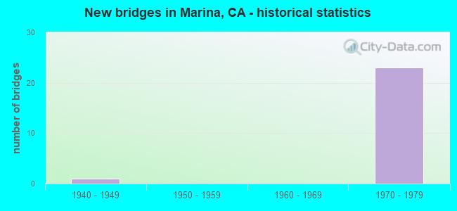
- New bridges - historical statistics
- 11940-1949
- 231970-1979
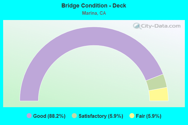
- Bridge Condition - Deck
- 88.2%Good
- 5.9%Satisfactory
- 5.9%Fair
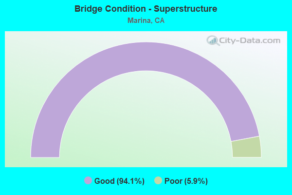
- Bridge Condition - Superstructure
- 94.1%Good
- 5.9%Poor
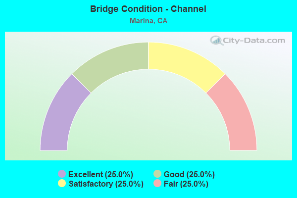
- Bridge Condition - Channel
- 25.0%Excellent
- 25.0%Good
- 25.0%Satisfactory
- 25.0%Fair
Find on map >> Show street view
Structure Number: 44 0201L, Location: 05-MON-001-R83.47 (Lat: 36.655269, Lng: -121.816561), Route carried "on" structure: State highway 1, Year Built: 1973, Status: Open, Structure Length: 5.35m (17.55ft), Average Daily Traffic: 29,500 (year 2009), Truck Traffic: 4%, Average Future Daily Traffic: 47,567 (year 2043), Design Load: HS 20, Features Intersected: PEDESTRIAN WALKWAY
Minimum Vertical Clearance: 30+ m (98+ ft), Kilometerpoint: 83.470, Lanes on structure: 3, Base Highway Network: Yes (, Subroute: 1), Owner: State Highway Agency, Approaching Roadway Width: 16.5m (54.1ft), Skew: 4 degrees, Material/Design: Concrete continuous, Design/Construction: Box Beam or Girders - Multiple, Number Of Spans In Main Unit: 3, Length of Maximum Span: 21.3m (69.9ft), Curb-To-Curb Width: 16.5m (54.1ft), Out-to-Out Width: 17.1m (56.1ft)
Condition: Deck: Good, Superstructure: Good, Substructure: Good, Operating Rating: 56.4 metric tons, Method Used To Determine Operating Rating: Load and Resistance Factor Rating (LRFR) rating reported by rating factor(RF) method using HL-93 loadings, Inventory Rating: 41.5 metric tons, Method Used To Determine Inventory Rating: Load and Resistance Factor Rating (LRFR) rating reported by rating factor(RF) method using HL-93 loadings, Structural Evaluation: Better than present minimum criteria, Deck Geometry: Equal to present minimum criteria, Approach Roadway Alignment: Equal to present desirable criteria, Designated Inspection Frequency: Every 48 months, Inspection Date: August 2021, Deck Structure Type: Concrete Cast-file-Place
Find on map >> Show street view
Structure Number: 44 0201R, Location: 05-MON-001-R83.47 (Lat: 36.655528, Lng: -121.816319), Route carried "on" structure: State highway 1, Year Built: 1973, Status: Open, Structure Length: 5.41m (17.75ft), Average Daily Traffic: 29,500 (year 2009), Truck Traffic: 4%, Average Future Daily Traffic: 47,567 (year 2043), Design Load: HS 20, Features Intersected: PEDESTRIAN WALKWAY
Minimum Vertical Clearance: 30+ m (98+ ft), Kilometerpoint: 83.470, Lanes on structure: 3, Base Highway Network: Yes (, Subroute: 1), Owner: State Highway Agency, Approaching Roadway Width: 15.2m (49.9ft), Skew: 4 degrees, Material/Design: Concrete continuous, Design/Construction: Box Beam or Girders - Multiple, Number Of Spans In Main Unit: 3, Length of Maximum Span: 21.6m (70.9ft), Curb-To-Curb Width: 15.5m (50.9ft), Out-to-Out Width: 16.1m (52.8ft)
Condition: Deck: Good, Superstructure: Good, Substructure: Good, Operating Rating: 54.8 metric tons, Method Used To Determine Operating Rating: Load and Resistance Factor Rating (LRFR) rating reported by rating factor(RF) method using HL-93 loadings, Inventory Rating: 39.2 metric tons, Method Used To Determine Inventory Rating: Load and Resistance Factor Rating (LRFR) rating reported by rating factor(RF) method using HL-93 loadings, Structural Evaluation: Better than present minimum criteria, Deck Geometry: Somewhat better than minimum adequacy, Approach Roadway Alignment: Equal to present desirable criteria, Designated Inspection Frequency: Every 48 months, Inspection Date: August 2021, Deck Structure Type: Concrete Cast-file-Place
Find on map >> Show street view
Structure Number: 44 0202, Location: 05-MON-001-R83.89 (Lat: 36.661353, Lng: -121.817183), Route carried "on" structure: County highway , Year Built: 1973, Status: Open, Structure Length: 10.42m (34.19ft), Average Daily Traffic: 1,000 (year 2005), Truck Traffic: 3%, Average Future Daily Traffic: 1,799 (year 2043), Design Load: HS 20+Mod, Features Intersected: SR 1, ABANDONED RR ROW, Facility Carried by Structure: EIGHTH ST
Minimum Vertical Clearance: 30+ m (98+ ft), Kilometerpoint: 0.000, Lanes on structure: 2, Lanes under structure: 6, Owner: State Highway Agency, Approaching Roadway Width: 12.2m (40.0ft), Material/Design: Concrete continuous, Design/Construction: Box Beam or Girders - Multiple, Number Of Spans In Main Unit: 3, Length of Maximum Span: 37.8m (124.0ft), Curb or Sidewalk Widths: Left: 1.5m (4.9ft), Right: 0.0m, Curb-To-Curb Width: 12.2m (40.0ft), Out-to-Out Width: 14.3m (46.9ft)
Condition: Deck: Good, Superstructure: Good, Substructure: Good, Operating Rating: 43.7 metric tons, Method Used To Determine Operating Rating: Load and Resistance Factor Rating (LRFR) rating reported by rating factor(RF) method using HL-93 loadings, Inventory Rating: 33.7 metric tons, Method Used To Determine Inventory Rating: Load and Resistance Factor Rating (LRFR) rating reported by rating factor(RF) method using HL-93 loadings, Structural Evaluation: Better than present minimum criteria, Deck Geometry: Equal to present desirable criteria, Underclear: High priority of corrective action, Approach Roadway Alignment: Equal to present desirable criteria, Designated Inspection Frequency: Every 24 months, Inspection Date: August 2021, Deck Structure Type: Concrete Cast-file-Place
Find on map >> Show street view
Structure Number: 44 0203, Location: 05-MON-001-R84.48 (Lat: 36.669514, Lng: -121.813358), Route carried "on" structure: County highway , Year Built: 1973, Status: Open, Structure Length: 6.02m (19.75ft), Average Daily Traffic: 11,950 (year 2015), Truck Traffic: 3%, Average Future Daily Traffic: 19,228 (year 2043), Design Load: HS 20+Mod, Features Intersected: STATE ROUTE 1, Facility Carried by Structure: 12TH ST/IMJIN PKWY
Minimum Vertical Clearance: 30+ m (98+ ft), Kilometerpoint: 0.000, Lanes on structure: 2, Lanes under structure: 6, Base Highway Network: Yes, Owner: State Highway Agency, Approaching Roadway Width: 12.2m (40.0ft), Material/Design: Concrete continuous, Design/Construction: Box Beam or Girders - Multiple, Number Of Spans In Main Unit: 2, Length of Maximum Span: 30.3m (99.4ft), Curb-To-Curb Width: 12.2m (40.0ft), Out-to-Out Width: 12.8m (42.0ft)
Condition: Deck: Good, Superstructure: Good, Substructure: Good, Operating Rating: 33.7 metric tons, Method Used To Determine Operating Rating: Load and Resistance Factor Rating (LRFR) rating reported by rating factor(RF) method using HL-93 loadings, Inventory Rating: 25.9 metric tons, Method Used To Determine Inventory Rating: Load and Resistance Factor Rating (LRFR) rating reported by rating factor(RF) method using HL-93 loadings, Structural Evaluation: Equal to present minimum criteria, Deck Geometry: Somewhat better than minimum adequacy, Underclear: Somewhat better than minimum adequacy, Approach Roadway Alignment: Better than present minimum criteria, Designated Inspection Frequency: Every 24 months, Inspection Date: August 2021, Deck Structure Type: Concrete Cast-file-Place
Find on map >> Show street view
Structure Number: 44 0211L, Location: 05-MON-001-R85.14 (Lat: 36.677928, Lng: -121.807764), Route carried "on" structure: State highway 1, Year Built: 1976, Status: Open, Structure Length: 21.33m (69.98ft), Average Daily Traffic: 29,500 (year 2009), Truck Traffic: 4%, Average Future Daily Traffic: 46,938 (year 2043), Design Load: HS 20+Mod, Features Intersected: RR ROW, DEL MONTE BL-S1
Minimum Vertical Clearance: 30+ m (98+ ft), Kilometerpoint: 85.140, Lanes on structure: 2, Lanes under structure: 2, Base Highway Network: Yes (, Subroute: 1), Owner: State Highway Agency, Approaching Roadway Width: 15.5m (50.9ft), Skew: 9 degrees, Material/Design: Prestressed concrete continuous, Design/Construction: Box Beam or Girders - Multiple, Number Of Spans In Main Unit: 5, Length of Maximum Span: 56.4m (185.0ft), Curb-To-Curb Width: 15.5m (50.9ft), Out-to-Out Width: 16.2m (53.1ft)
Condition: Deck: Good, Superstructure: Good, Substructure: Good, Operating Rating: 99.8 metric tons, Method Used To Determine Operating Rating: Load Factor (LF), Inventory Rating: 32.4 metric tons, Method Used To Determine Inventory Rating: Load Factor (LF), Structural Evaluation: Better than present minimum criteria, Deck Geometry: Superior to present desirable criteria, Underclear: Meets minimum limits, Approach Roadway Alignment: Equal to present desirable criteria, Designated Inspection Frequency: Every 24 months, Inspection Date: August 2021, Deck Structure Type: Concrete Cast-file-Place
Find on map >> Show street view
Structure Number: 44 0211R, Location: 05-MON-001-R85.14 (Lat: 36.678550, Lng: -121.807275), Route carried "on" structure: State highway 1, Year Built: 1976, Status: Open, Structure Length: 17.69m (58.04ft), Average Daily Traffic: 29,500 (year 2009), Truck Traffic: 4%, Average Future Daily Traffic: 46,938 (year 2043), Design Load: HS 20+Mod, Features Intersected: RR ROW, DEL MONTE BL-S1
Minimum Vertical Clearance: 30+ m (98+ ft), Kilometerpoint: 85.140, Lanes on structure: 2, Lanes under structure: 2, Base Highway Network: Yes (, Subroute: 1), Owner: State Highway Agency, Approaching Roadway Width: 15.5m (50.9ft), Skew: 9 degrees, Material/Design: Prestressed concrete continuous, Design/Construction: Box Beam or Girders - Multiple, Number Of Spans In Main Unit: 4, Length of Maximum Span: 50.0m (164.0ft), Curb-To-Curb Width: 15.5m (50.9ft), Out-to-Out Width: 16.2m (53.1ft)
Condition: Deck: Good, Superstructure: Good, Substructure: Good, Operating Rating: 99.8 metric tons, Method Used To Determine Operating Rating: Load Factor (LF), Inventory Rating: 32.4 metric tons, Method Used To Determine Inventory Rating: Load Factor (LF), Structural Evaluation: Better than present minimum criteria, Deck Geometry: Superior to present desirable criteria, Underclear: Somewhat better than minimum adequacy, Approach Roadway Alignment: Equal to present desirable criteria, Designated Inspection Frequency: Every 24 months, Inspection Date: August 2021, Deck Structure Type: Concrete Cast-file-Place
Find on map >> Show street view
Structure Number: 44 0212L, Location: 05-MON-001-R85.51 (Lat: 36.683058, Lng: -121.808467), Route carried "on" structure: State highway 1, Year Built: 1976, Status: Open, Structure Length: 4.54m (14.90ft), Average Daily Traffic: 23,000 (year 2009), Truck Traffic: 4%, Average Future Daily Traffic: 26,943 (year 2043), Design Load: HS 20+Mod, Features Intersected: LAKE DRIVE
Minimum Vertical Clearance: 30+ m (98+ ft), Kilometerpoint: 85.510, Lanes on structure: 2, Lanes under structure: 2, Base Highway Network: Yes (, Subroute: 1), Owner: State Highway Agency, Approaching Roadway Width: 11.9m (39.0ft), Material/Design: Prestressed concrete, Design/Construction: Box Beam or Girders - Multiple, Number Of Spans In Main Unit: 1, Length of Maximum Span: 45.4m (149.0ft), Curb-To-Curb Width: 11.9m (39.0ft), Out-to-Out Width: 12.5m (41.0ft)
Condition: Deck: Good, Superstructure: Good, Substructure: Good, Operating Rating: 50.9 metric tons, Method Used To Determine Operating Rating: Load and Resistance Factor Rating (LRFR) rating reported by rating factor(RF) method using HL-93 loadings, Inventory Rating: 34.3 metric tons, Method Used To Determine Inventory Rating: Load and Resistance Factor Rating (LRFR) rating reported by rating factor(RF) method using HL-93 loadings, Structural Evaluation: Better than present minimum criteria, Deck Geometry: Equal to present minimum criteria, Underclear: Better than present minimum criteria, Approach Roadway Alignment: Equal to present desirable criteria, Designated Inspection Frequency: Every 24 months, Inspection Date: August 2021, Deck Structure Type: Concrete Cast-file-Place
Find on map >> Show street view
Structure Number: 44 0212R, Location: 05-MON-001-R85.51 (Lat: 36.683139, Lng: -121.808053), Route carried "on" structure: State highway 1, Year Built: 1976, Status: Open, Structure Length: 4.54m (14.90ft), Average Daily Traffic: 23,000 (year 2009), Truck Traffic: 4%, Average Future Daily Traffic: 26,943 (year 2043), Design Load: HS 20+Mod, Features Intersected: LAKE DRIVE
Minimum Vertical Clearance: 30+ m (98+ ft), Kilometerpoint: 85.510, Lanes on structure: 2, Lanes under structure: 2, Base Highway Network: Yes (, Subroute: 1), Owner: State Highway Agency, Approaching Roadway Width: 11.9m (39.0ft), Material/Design: Prestressed concrete, Design/Construction: Box Beam or Girders - Multiple, Number Of Spans In Main Unit: 1, Length of Maximum Span: 45.4m (149.0ft), Curb-To-Curb Width: 11.9m (39.0ft), Out-to-Out Width: 12.5m (41.0ft)
Condition: Deck: Good, Superstructure: Good, Substructure: Good, Operating Rating: 50.9 metric tons, Method Used To Determine Operating Rating: Load and Resistance Factor Rating (LRFR) rating reported by rating factor(RF) method using HL-93 loadings, Inventory Rating: 34.3 metric tons, Method Used To Determine Inventory Rating: Load and Resistance Factor Rating (LRFR) rating reported by rating factor(RF) method using HL-93 loadings, Structural Evaluation: Better than present minimum criteria, Deck Geometry: Equal to present minimum criteria, Underclear: Equal to present desirable criteria, Approach Roadway Alignment: Equal to present desirable criteria, Designated Inspection Frequency: Every 24 months, Inspection Date: August 2021, Deck Structure Type: Concrete Cast-file-Place
Find on map >> Show street view
Structure Number: 44 0213L, Location: 05-MON-001-R86.48 (Lat: 36.696661, Lng: -121.805103), Route carried "on" structure: State highway 1, Year Built: 1976, Status: Open, Structure Length: 4.51m (14.80ft), Average Daily Traffic: 23,000 (year 2009), Truck Traffic: 4%, Average Future Daily Traffic: 26,943 (year 2043), Design Load: HS 20+Mod, Features Intersected: RESERVATION RD
Minimum Vertical Clearance: 30+ m (98+ ft), Kilometerpoint: 86.480, Lanes on structure: 2, Lanes under structure: 2, Base Highway Network: Yes (, Subroute: 1), Owner: State Highway Agency, Approaching Roadway Width: 11.9m (39.0ft), Material/Design: Prestressed concrete, Design/Construction: Box Beam or Girders - Multiple, Number Of Spans In Main Unit: 1, Length of Maximum Span: 45.1m (148.0ft), Curb-To-Curb Width: 11.9m (39.0ft), Out-to-Out Width: 12.5m (41.0ft)
Condition: Deck: Good, Superstructure: Good, Substructure: Good, Operating Rating: 51.8 metric tons, Method Used To Determine Operating Rating: Load and Resistance Factor Rating (LRFR) rating reported by rating factor(RF) method using HL-93 loadings, Inventory Rating: 35.6 metric tons, Method Used To Determine Inventory Rating: Load and Resistance Factor Rating (LRFR) rating reported by rating factor(RF) method using HL-93 loadings, Structural Evaluation: Better than present minimum criteria, Deck Geometry: Equal to present minimum criteria, Underclear: Better than present minimum criteria, Approach Roadway Alignment: Equal to present desirable criteria, Designated Inspection Frequency: Every 24 months, Inspection Date: August 2021, Deck Structure Type: Concrete Cast-file-Place
Find on map >> Show street view
Structure Number: 44 0213R, Location: 05-MON-001-R86.48 (Lat: 36.696508, Lng: -121.804728), Route carried "on" structure: State highway 1, Year Built: 1976, Status: Open, Structure Length: 4.51m (14.80ft), Average Daily Traffic: 23,000 (year 2009), Truck Traffic: 4%, Average Future Daily Traffic: 26,943 (year 2043), Design Load: HS 20+Mod, Features Intersected: RESERVATION RD
Minimum Vertical Clearance: 30+ m (98+ ft), Kilometerpoint: 86.480, Lanes on structure: 2, Lanes under structure: 2, Base Highway Network: Yes (, Subroute: 1), Owner: State Highway Agency, Approaching Roadway Width: 11.9m (39.0ft), Material/Design: Prestressed concrete, Design/Construction: Box Beam or Girders - Multiple, Number Of Spans In Main Unit: 1, Length of Maximum Span: 45.1m (148.0ft), Curb-To-Curb Width: 11.9m (39.0ft), Out-to-Out Width: 12.5m (41.0ft)
Condition: Deck: Good, Superstructure: Good, Substructure: Good, Operating Rating: 52.5 metric tons, Method Used To Determine Operating Rating: Load and Resistance Factor Rating (LRFR) rating reported by rating factor(RF) method using HL-93 loadings, Inventory Rating: 35.0 metric tons, Method Used To Determine Inventory Rating: Load and Resistance Factor Rating (LRFR) rating reported by rating factor(RF) method using HL-93 loadings, Structural Evaluation: Better than present minimum criteria, Deck Geometry: Equal to present minimum criteria, Underclear: Better than present minimum criteria, Approach Roadway Alignment: Equal to present desirable criteria, Designated Inspection Frequency: Every 24 months, Inspection Date: August 2021, Deck Structure Type: Concrete Cast-file-Place
Find on map >> Show street view
Structure Number: 44 0214L, Location: 05-MON-001-R87.65 (Lat: 36.711839, Lng: -121.796458), Route carried "on" structure: State highway 1, Year Built: 1976, Status: Open, Structure Length: 9.06m (29.72ft), Average Daily Traffic: 23,500 (year 2009), Truck Traffic: 8%, Average Future Daily Traffic: 26,387 (year 2043), Design Load: HS 20+Mod, Features Intersected: ACCESS ROAD
Minimum Vertical Clearance: 30+ m (98+ ft), Kilometerpoint: 87.650, Lanes on structure: 2, Lanes under structure: 2, Base Highway Network: Yes (, Subroute: 1), Owner: State Highway Agency, Approaching Roadway Width: 11.9m (39.0ft), Skew: 4 degrees, Material/Design: Prestressed concrete continuous, Design/Construction: Box Beam or Girders - Multiple, Number Of Spans In Main Unit: 2, Length of Maximum Span: 47.6m (156.2ft), Curb-To-Curb Width: 11.9m (39.0ft), Out-to-Out Width: 12.5m (41.0ft)
Condition: Deck: Good, Superstructure: Good, Substructure: Good, Operating Rating: 68.0 metric tons, Method Used To Determine Operating Rating: Load and Resistance Factor Rating (LRFR) rating reported by rating factor(RF) method using HL-93 loadings, Inventory Rating: 46.3 metric tons, Method Used To Determine Inventory Rating: Load and Resistance Factor Rating (LRFR) rating reported by rating factor(RF) method using HL-93 loadings, Structural Evaluation: Better than present minimum criteria, Deck Geometry: Better than present minimum criteria, Underclear: Somewhat better than minimum adequacy, Approach Roadway Alignment: Equal to present desirable criteria, Designated Inspection Frequency: Every 24 months, Inspection Date: August 2021, Deck Structure Type: Concrete Cast-file-Place
Find on map >> Show street view
Structure Number: 44 0214R, Location: 05-MON-001-R87.65 (Lat: 36.712019, Lng: -121.795908), Route carried "on" structure: State highway 1, Year Built: 1976, Status: Open, Structure Length: 9.04m (29.66ft), Average Daily Traffic: 23,500 (year 2009), Truck Traffic: 8%, Average Future Daily Traffic: 26,387 (year 2043), Design Load: HS 20+Mod, Features Intersected: ACCESS ROAD
Minimum Vertical Clearance: 30+ m (98+ ft), Kilometerpoint: 87.650, Lanes on structure: 2, Lanes under structure: 2, Base Highway Network: Yes (, Subroute: 1), Owner: State Highway Agency, Approaching Roadway Width: 11.9m (39.0ft), Skew: 4 degrees, Material/Design: Prestressed concrete continuous, Design/Construction: Box Beam or Girders - Multiple, Number Of Spans In Main Unit: 2, Length of Maximum Span: 47.6m (156.2ft), Curb-To-Curb Width: 11.9m (39.0ft), Out-to-Out Width: 12.5m (41.0ft)
Condition: Deck: Good, Superstructure: Good, Substructure: Good, Operating Rating: 68.7 metric tons, Method Used To Determine Operating Rating: Load and Resistance Factor Rating (LRFR) rating reported by rating factor(RF) method using HL-93 loadings, Inventory Rating: 46.7 metric tons, Method Used To Determine Inventory Rating: Load and Resistance Factor Rating (LRFR) rating reported by rating factor(RF) method using HL-93 loadings, Structural Evaluation: Better than present minimum criteria, Deck Geometry: Better than present minimum criteria, Underclear: Somewhat better than minimum adequacy, Approach Roadway Alignment: Equal to present desirable criteria, Designated Inspection Frequency: Every 24 months, Inspection Date: August 2021, Deck Structure Type: Concrete Cast-file-Place
Find on map >> Show street view
Structure Number: 44 0215, Location: 05-MON-001-R88.64 (Lat: 36.725611, Lng: -121.789831), Route carried "on" structure: City street , Year Built: 1976, Status: Open, Structure Length: 10.58m (34.71ft), Average Daily Traffic: 4,900 (year 2005), Truck Traffic: 3%, Average Future Daily Traffic: 8,482 (year 2043), Design Load: HS 20+Mod, Features Intersected: STATE ROUTE 1, Facility Carried by Structure: DEL MONTE BLVD
Minimum Vertical Clearance: 30+ m (98+ ft), Kilometerpoint: 0.000, Lanes on structure: 2, Lanes under structure: 5, Owner: State Highway Agency, Approaching Roadway Width: 12.2m (40.0ft), Skew: 3 degrees, Material/Design: Prestressed concrete continuous, Design/Construction: Box Beam or Girders - Multiple, Number Of Spans In Main Unit: 2, Length of Maximum Span: 56.4m (185.0ft), Curb or Sidewalk Widths: Left: 1.5m (4.9ft), Right: 0.0m, Curb-To-Curb Width: 12.2m (40.0ft), Out-to-Out Width: 14.3m (46.9ft)
Condition: Deck: Good, Superstructure: Good, Substructure: Good, Operating Rating: 66.7 metric tons, Method Used To Determine Operating Rating: Load and Resistance Factor Rating (LRFR) rating reported by rating factor(RF) method using HL-93 loadings, Inventory Rating: 43.4 metric tons, Method Used To Determine Inventory Rating: Load and Resistance Factor Rating (LRFR) rating reported by rating factor(RF) method using HL-93 loadings, Structural Evaluation: Better than present minimum criteria, Deck Geometry: Equal to present minimum criteria, Underclear: Equal to present minimum criteria, Approach Roadway Alignment: Equal to present desirable criteria, Designated Inspection Frequency: Every 24 months, Inspection Date: August 2021, Deck Structure Type: Concrete Cast-file-Place
Find on map >> Show street view
Structure Number: 44 0216L, Location: 05-MON-001-R89.18 (Lat: 36.731447, Lng: -121.783572), Route carried "on" structure: State highway 1, Year Built: 1976, Status: Open, Structure Length: 23.55m (77.26ft), Average Daily Traffic: 23,500 (year 2009), Truck Traffic: 8%, Average Future Daily Traffic: 26,387 (year 2043), Design Load: HS 20, Features Intersected: SALINAS RIVER
Minimum Vertical Clearance: 30+ m (98+ ft), Kilometerpoint: 89.180, Lanes on structure: 2, Base Highway Network: Yes (, Subroute: 1), Owner: State Highway Agency, Approaching Roadway Width: 11.9m (39.0ft), Skew: 2 degrees, Material/Design: Prestressed concrete continuous, Design/Construction: Box Beam or Girders - Multiple, Number Of Spans In Main Unit: 5, Length of Maximum Span: 48.8m (160.1ft), Curb-To-Curb Width: 11.7m (38.4ft), Out-to-Out Width: 12.7m (41.7ft)
Condition: Deck: Good, Superstructure: Good, Substructure: Good, Channel: Satisfactory, Operating Rating: 35.3 metric tons, Method Used To Determine Operating Rating: Load and Resistance Factor Rating (LRFR) rating reported by rating factor(RF) method using HL-93 loadings, Inventory Rating: 26.6 metric tons, Method Used To Determine Inventory Rating: Load and Resistance Factor Rating (LRFR) rating reported by rating factor(RF) method using HL-93 loadings, Structural Evaluation: Equal to present minimum criteria, Deck Geometry: Better than present minimum criteria, Waterway Adequacy: Superior to present desirable criteria, Approach Roadway Alignment: Equal to present desirable criteria, Designated Inspection Frequency: Every 24 months, Underwater Inspection Frequency: Every 60 months, Inspection Date: August 2021, Underwater Inspection Date: September 2019, Deck Structure Type: Concrete Cast-file-Place
Find on map >> Show street view
Structure Number: 44 0216R, Location: 05-MON-001-R89.19 (Lat: 36.731331, Lng: -121.783144), Route carried "on" structure: State highway 1, Year Built: 1976, Status: Open, Structure Length: 23.55m (77.26ft), Average Daily Traffic: 23,500 (year 2009), Truck Traffic: 8%, Average Future Daily Traffic: 26,387 (year 2043), Design Load: HS 20, Features Intersected: SALINAS RIVER
Minimum Vertical Clearance: 30+ m (98+ ft), Kilometerpoint: 89.190, Lanes on structure: 2, Base Highway Network: Yes (, Subroute: 1), Owner: State Highway Agency, Approaching Roadway Width: 11.9m (39.0ft), Skew: 2 degrees, Material/Design: Prestressed concrete continuous, Design/Construction: Box Beam or Girders - Multiple, Number Of Spans In Main Unit: 5, Length of Maximum Span: 48.8m (160.1ft), Curb-To-Curb Width: 11.7m (38.4ft), Out-to-Out Width: 12.7m (41.7ft)
Condition: Deck: Good, Superstructure: Good, Substructure: Good, Channel: Fair, Operating Rating: 35.3 metric tons, Method Used To Determine Operating Rating: Load and Resistance Factor Rating (LRFR) rating reported by rating factor(RF) method using HL-93 loadings, Inventory Rating: 26.6 metric tons, Method Used To Determine Inventory Rating: Load and Resistance Factor Rating (LRFR) rating reported by rating factor(RF) method using HL-93 loadings, Structural Evaluation: Equal to present minimum criteria, Deck Geometry: Better than present minimum criteria, Waterway Adequacy: Superior to present desirable criteria, Approach Roadway Alignment: Equal to present desirable criteria, Designated Inspection Frequency: Every 24 months, Underwater Inspection Frequency: Every 60 months, Inspection Date: August 2021, Underwater Inspection Date: September 2019, Deck Structure Type: Concrete Cast-file-Place
Find on map >> Show street view
Structure Number: 44C0022, Location: 1 MI NE RESERVATION RD (Lat: 36.677600, Lng: -121.746583), Route carried "on" structure: County highway , Year Built: 1971, Status: Open, Structure Length: 24.54m (80.51ft), Average Daily Traffic: 26,300 (year 2017), Truck Traffic: 8%, Average Future Daily Traffic: 25,754 (year 2038), Design Load: HS 20, Features Intersected: SALINAS RIVER, Facility Carried by Structure: BLANCO RD
Minimum Vertical Clearance: 30+ m (98+ ft), Kilometerpoint: 0.000, Lanes on structure: 2, Owner: County Highway Agency, Approaching Roadway Width: 11.3m (37.1ft), Skew: 9 degrees, Material/Design: Concrete continuous, Design/Construction: Box Beam or Girders - Multiple, Number Of Spans In Main Unit: 9, Length of Maximum Span: 30.5m (100.1ft), Curb-To-Curb Width: 11.3m (37.1ft), Out-to-Out Width: 11.5m (37.7ft)
Condition: Deck: Satisfactory, Superstructure: Good, Substructure: Good, Channel: Excellent, Operating Rating: 88.1 metric tons, Method Used To Determine Operating Rating: Load Factor (LF), Inventory Rating: 52.8 metric tons, Method Used To Determine Inventory Rating: Load Factor (LF), Structural Evaluation: Better than present minimum criteria, Deck Geometry: Meets minimum limits, Waterway Adequacy: Better than present minimum criteria, Approach Roadway Alignment: Better than present minimum criteria, Designated Inspection Frequency: Every 24 months, Inspection Date: September 2021, Deck Structure Type: Concrete Cast-file-Place
Find on map >> Show street view
Structure Number: 44C0093, Location: 0.75 MI N DEL MONTE BLVD (Lat: 36.731247, Lng: -121.782764), Route carried "on" structure: County highway , Year Built: 1943, Status: Open, Structure Length: 23.93m (78.51ft), Average Daily Traffic: 2,200 (year 2017), Truck Traffic: 15%, Average Future Daily Traffic: 4,271 (year 2038), Design Load: H 15, Features Intersected: SALINAS RIVER, Facility Carried by Structure: MONTE RD
Minimum Vertical Clearance: 30+ m (98+ ft), Kilometerpoint: 0.000, Lanes on structure: 2, Owner: County Highway Agency, Approaching Roadway Width: 11.6m (38.1ft), Skew: 2 degrees, Material/Design: Steel continuous, Design/Construction: Stringer/Multi-beam, Number Of Spans In Main Unit: 7, Length of Maximum Span: 46.9m (153.9ft), Curb or Sidewalk Widths: Left: 0.6m (2.0ft), Right: 0.6m (2.0ft), Curb-To-Curb Width: 7.9m (25.9ft), Out-to-Out Width: 9.7m (31.8ft)
Condition: Deck: Fair, Superstructure: Poor, Substructure: Good, Channel: Good, Operating Rating: 44.1 metric tons, Method Used To Determine Operating Rating: Load Factor (LF), Inventory Rating: 26.6 metric tons, Method Used To Determine Inventory Rating: Load Factor (LF), Structural Evaluation: Meets minimum limits, Deck Geometry: High priority of corrective action, Waterway Adequacy: Equal to present minimum criteria, Approach Roadway Alignment: Equal to present desirable criteria, Length Of Structure Improvement: 23.93m (78.51ft), Designated Inspection Frequency: Every 24 months, Critical Feature Inspection Frequency: Every 24 months, Underwater Inspection Frequency: Every 60 months, Inspection Date: September 2021, Critical Feature Inspection Date: April 2021, Underwater Inspection Date: September 2019, Bridge Improvement Cost: $2,294,000, Roadway Improvement Cost: $1,058,000, Total Project Cost: $8,887,000 ( Estimate for 2017), Deck Structure Type: Concrete Cast-file-Place, Wearing Surface/Protective System: Wearing Surface: Integral Concrete
Find on map >> Show street view
Structure Number: 44 0202, Location: 05-MON-001-R83.89 (Lat: 36.661353, Lng: -121.817183), Route carried "under" structure: State highway 1, Year Built: 1973, Structure Length: 0. m, Average Daily Traffic: 59,000 (year 2009), Truck Traffic: 4%, Features Intersected: SR 1, ABANDONED RR ROW, Facility Carried by Structure: EIGHTH ST
Minimum Vertical Clearance: 5.05m (16.57ft), Kilometerpoint: 83.890, Lanes on structure: 2, Lanes under structure: 6, Material/Design: Concrete continuous, Design/Construction: Box Beam or Girders - Multiple, Length of Maximum Span: 37.8m (124.0ft)
Find on map >> Show street view
Structure Number: 44 0203, Location: 05-MON-001-R84.48 (Lat: 36.669514, Lng: -121.813358), Route carried "under" structure: State highway 1, Year Built: 1973, Structure Length: 0. m, Average Daily Traffic: 59,000 (year 2009), Truck Traffic: 4%, Features Intersected: STATE ROUTE 1
Minimum Vertical Clearance: 5.31m (17.42ft), Kilometerpoint: 84.480, Lanes on structure: 2, Lanes under structure: 6, Material/Design: Concrete continuous, Design/Construction: Box Beam or Girders - Multiple, Length of Maximum Span: 30.3m (99.4ft)
Find on map >> Show street view
Structure Number: 44 0211L, Location: 05-MON-001-R85.14 (Lat: 36.677928, Lng: -121.807764), Route carried "under" structure: Ramp City street , Year Built: 1976, Structure Length: 0. m, Average Daily Traffic: 9,400 (year 2013), Truck Traffic: 5%, Features Intersected: RR ROW, DEL MONTE BL-S1, Facility Carried by Structure: STATE ROUTE 1 SB
Minimum Vertical Clearance: 5.33m (17.49ft), Kilometerpoint: 0.000, Lanes on structure: 2, Lanes under structure: 2, Material/Design: Prestressed concrete continuous, Design/Construction: Box Beam or Girders - Multiple, Length of Maximum Span: 56.4m (185.0ft)
Find on map >> Show street view
Structure Number: 44 0211R, Location: 05-MON-001-R85.14 (Lat: 36.678550, Lng: -121.807275), Route carried "under" structure: Ramp City street , Year Built: 1976, Structure Length: 0. m, Average Daily Traffic: 9,400 (year 2013), Truck Traffic: 5%, Features Intersected: RR ROW, DEL MONTE BL-S1, Facility Carried by Structure: STATE ROUTE 1 NB
Minimum Vertical Clearance: 8.18m (26.84ft), Kilometerpoint: 0.000, Lanes on structure: 2, Lanes under structure: 2, Material/Design: Prestressed concrete continuous, Design/Construction: Box Beam or Girders - Multiple, Length of Maximum Span: 50.0m (164.0ft)
Find on map >> Show street view
Structure Number: 44 0213L, Location: 05-MON-001-R86.48 (Lat: 36.696661, Lng: -121.805103), Route carried "under" structure: Business City street , Year Built: 1976, Structure Length: 0. m, Average Daily Traffic: 8,450 (year 2005), Truck Traffic: 10%, Features Intersected: RESERVATION RD, Facility Carried by Structure: STATE ROUTE 1 SB
Minimum Vertical Clearance: 4.92m (16.14ft), Kilometerpoint: 0.000, Lanes on structure: 2, Lanes under structure: 2, Material/Design: Prestressed concrete, Design/Construction: Box Beam or Girders - Multiple, Length of Maximum Span: 45.1m (148.0ft)
Find on map >> Show street view
Structure Number: 44 0213R, Location: 05-MON-001-R86.48 (Lat: 36.696508, Lng: -121.804728), Route carried "under" structure: Business City street , Year Built: 1976, Structure Length: 0. m, Average Daily Traffic: 8,400 (year 2005), Truck Traffic: 10%, Features Intersected: RESERVATION RD, Facility Carried by Structure: STATE ROUTE 1 NB
Minimum Vertical Clearance: 5.23m (17.16ft), Kilometerpoint: 0.000, Lanes on structure: 2, Lanes under structure: 2, Material/Design: Prestressed concrete, Design/Construction: Box Beam or Girders - Multiple, Length of Maximum Span: 45.1m (148.0ft)
Find on map >> Show street view
Structure Number: 44 0215, Location: 05-MON-001-R88.64 (Lat: 36.725611, Lng: -121.789831), Route carried "under" structure: State highway 1, Year Built: 1976, Structure Length: 0. m, Average Daily Traffic: 47,000 (year 2009), Truck Traffic: 8%, Features Intersected: STATE ROUTE 1, Facility Carried by Structure: DEL MONTE BLVD
Minimum Vertical Clearance: 5.02m (16.47ft), Kilometerpoint: 88.640, Lanes on structure: 2, Lanes under structure: 5, Material/Design: Prestressed concrete continuous, Design/Construction: Box Beam or Girders - Multiple, Length of Maximum Span: 56.4m (185.0ft)