Bridge Statistics for Marble, North Carolina (NC)
Condition, Traffic, Stress, Structural Evaluation, Project Costs
- National Bridge Inventory (NBI) Statistics
- 20Number of bridges
- 194ft / 59.2mTotal length
- $11,000Total costs
- 50,804Total average daily traffic
- 6,293Total average daily truck traffic
- 101,505Total future (year 2039) average daily traffic
- National Bridge Inventory (NBI) Registered Bridges for Marble
- No street view available for this location
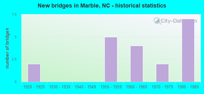
- New bridges - historical statistics
- 21920-1929
- 51950-1959
- 41960-1969
- 21970-1979
- 71980-1989

- Reconstructed bridges - Historical Statistics
- 11970-1979
- 01980-1989
- 01990-1999
- 02000-2009
- 12010-2019


- Bridge Condition - Deck
- 88.2%Good
- 11.8%Satisfactory

- Bridge Condition - Superstructure
- 58.8%Good
- 35.3%Satisfactory
- 5.9%Fair

- Bridge Condition - Substructure
- 70.6%Good
- 23.5%Satisfactory
- 5.9%Fair

- Bridge Condition - Channel
- 95.0%Good
- 5.0%Satisfactory

- Bridge Condition - Culverts
- 66.7%Good
- 33.3%Satisfactory
Find on map >> Show street view
Structure Number: T034, Location: PRIVATE DRIVE (Lat: 35.152061, Lng: -83.898789), Route carried "on" structure: ServiceFederal lands road 34, Year Built: 1950, Status: Open, Structure Length: 0.61m (2.00ft), Average Daily Traffic: 4 (year 2019), Average Future Daily Traffic: 5 (year 2039), Features Intersected: UNKNOWN CREEK, Facility Carried by Structure: PRIVATE DRIVE
Minimum Vertical Clearance: 0.00m, Kilometerpoint: 0.000, Lanes on structure: 1, Owner: Indian Tribal Government, Approaching Roadway Width: 2.7m (8.9ft), Material/Design: Steel, Design/Construction: Stringer/Multi-beam, Number Of Spans In Main Unit: 1, Length of Maximum Span: 3.5m (11.5ft), Curb-To-Curb Width: 3.0m (9.8ft), Out-to-Out Width: 3.2m (10.5ft)
Condition: Deck: Good, Superstructure: Satisfactory, Substructure: Fair, Channel: Good, Operating Rating: 42.6 metric tons, Method Used To Determine Operating Rating: No rating analysis performed, Inventory Rating: 25.4 metric tons, Method Used To Determine Inventory Rating: No rating analysis performed, Structural Evaluation: Somewhat better than minimum adequacy, Deck Geometry: High priority of replacement, Approach Roadway Alignment: High priority of corrective action, Bridge Posting: Required (Relationship of Operating Rating to Maximum Legal Load: > 39.9% below), Designated Inspection Frequency: Every 24 months, Critical Feature Inspection Frequency: Every 24 months, Inspection Date: Febuary 2021, Critical Feature Inspection Date: Febuary 2021, Bridge Improvement Cost: $7,000, Roadway Improvement Cost: $1,000, Total Project Cost: $11,000 ( Estimate for 2019), Deck Structure Type: Wood or Timber, Wearing Surface/Protective System: Wearing Surface: Wood or Timber
Find on map >> Show street view
Structure Number: 390005, Location: .1 MI.S.JCT.SR1521 (Lat: 35.170103, Lng: -83.922994), Route carried "on" structure: State highway 141, Year Built: 1955, Status: Open, Structure Length: 4.81m (15.78ft), Average Daily Traffic: 3,600 (year 2013), Truck Traffic: 7%, Average Future Daily Traffic: 7,200 (year 2040), Design Load: H 15, Features Intersected: VALLEY RIVER
Minimum Vertical Clearance: 30+ m (98+ ft), Kilometerpoint: 0.000, Lanes on structure: 2, Owner: State Highway Agency, Approaching Roadway Width: 7.9m (25.9ft), Skew: 2 degrees, Material/Design: Steel, Design/Construction: Stringer/Multi-beam, Number Of Spans In Main Unit: 3, Length of Maximum Span: 15.5m (50.9ft), Curb or Sidewalk Widths: Left: 0.3m (1.0ft), Right: 0.3m (1.0ft), Curb-To-Curb Width: 7.3m (24.0ft), Out-to-Out Width: 8.0m (26.2ft)
Condition: Deck: Good, Superstructure: Fair, Substructure: Good, Channel: Good, Operating Rating: 42.6 metric tons, Method Used To Determine Operating Rating: Load Factor (LF), Inventory Rating: 25.4 metric tons, Method Used To Determine Inventory Rating: Load Factor (LF), Structural Evaluation: Somewhat better than minimum adequacy, Deck Geometry: High priority of replacement, Waterway Adequacy: Better than present minimum criteria, Approach Roadway Alignment: Equal to present desirable criteria, Designated Inspection Frequency: Every 24 months, Underwater Inspection Frequency: Every 48 months, Inspection Date: April 2020, Underwater Inspection Date: July 2018, Deck Structure Type: Concrete Cast-file-Place, Wearing Surface/Protective System: Wearing Surface: Bituminous
Find on map >> Show street view
Structure Number: 390021, Location: .2 MI.NE.JCT.SR1517 (Lat: 35.177783, Lng: -83.887836), Route carried "on" structure: State highway 1515, Year Built: 1951, Status: Posted for load, Structure Length: 0.79m (2.59ft), Average Daily Traffic: 800 (year 2018), Truck Traffic: 6%, Average Future Daily Traffic: 1,600 (year 2040), Features Intersected: TAYLOR CREEK
Minimum Vertical Clearance: 30+ m (98+ ft), Kilometerpoint: 0.000, Lanes on structure: 2, Owner: State Highway Agency, Approaching Roadway Width: 5.1m (16.7ft), Skew: 1 degrees, Material/Design: Steel, Design/Construction: Stringer/Multi-beam, Number Of Spans In Main Unit: 1, Length of Maximum Span: 7.3m (24.0ft), Curb-To-Curb Width: 6.5m (21.3ft), Out-to-Out Width: 6.8m (22.3ft)
Condition: Deck: Good, Superstructure: Satisfactory, Substructure: Good, Channel: Good, Operating Rating: 32.6 metric tons, Method Used To Determine Operating Rating: Load Factor (LF), Inventory Rating: 19.0 metric tons, Method Used To Determine Inventory Rating: Load Factor (LF), Structural Evaluation: Somewhat better than minimum adequacy, Deck Geometry: High priority of corrective action, Waterway Adequacy: Better than present minimum criteria, Approach Roadway Alignment: Equal to present minimum criteria, Bridge Posting: Required (Relationship of Operating Rating to Maximum Legal Load: 20.0 - 29.9% below), Designated Inspection Frequency: Every 24 months, Inspection Date: June 2020, Deck Structure Type: Wood or Timber, Wearing Surface/Protective System: Wearing Surface: Bituminous
Find on map >> Show street view
Structure Number: 390064, Location: .1 MI.S.JCT.SR1425 (Lat: 35.144619, Lng: -83.969967), Route carried "on" structure: Bypass US 19, Year Built: 1980, Status: Open, Structure Length: 6.76m (22.18ft), Average Daily Traffic: 4,150 (year 2012), Truck Traffic: 14%, Average Future Daily Traffic: 8,300 (year 2040), Design Load: HS 20+Mod, Features Intersected: VALLEY RIVER
Minimum Vertical Clearance: 30+ m (98+ ft), Kilometerpoint: 7.955, Lanes on structure: 2, Base Highway Network: Yes (Inventory Route: 2, Subroute: 59), Owner: State Highway Agency, Approaching Roadway Width: 10.9m (35.8ft), Skew: 13 degrees, Material/Design: Steel continuous, Design/Construction: Stringer/Multi-beam, Number Of Spans In Main Unit: 3, Length of Maximum Span: 24.6m (80.7ft), Curb-To-Curb Width: 11.8m (38.7ft), Out-to-Out Width: 12.9m (42.3ft)
Condition: Deck: Good, Superstructure: Good, Substructure: Good, Channel: Good, Operating Rating: 72.5 metric tons, Method Used To Determine Operating Rating: Load Factor (LF), Inventory Rating: 43.5 metric tons, Method Used To Determine Inventory Rating: Load Factor (LF), Structural Evaluation: Better than present minimum criteria, Deck Geometry: Better than present minimum criteria, Waterway Adequacy: Equal to present desirable criteria, Approach Roadway Alignment: Equal to present desirable criteria, Designated Inspection Frequency: Every 24 months, Inspection Date: June 2020, Deck Structure Type: Concrete Cast-file-Place, Wearing Surface/Protective System: Wearing Surface: Bituminous, Deck Protection: Epoxy Coated Reinforcing
Find on map >> Show street view
Structure Number: 390067, Location: .1 MI.S.JCT.SR1425 (Lat: 35.144625, Lng: -83.970225), Route carried "on" structure: Bypass US 19, Year Built: 1980, Status: Open, Structure Length: 6.76m (22.18ft), Average Daily Traffic: 4,150 (year 2012), Truck Traffic: 14%, Average Future Daily Traffic: 8,300 (year 2040), Design Load: HS 20+Mod, Features Intersected: VALLEY RIVER
Minimum Vertical Clearance: 30+ m (98+ ft), Kilometerpoint: 7.955, Lanes on structure: 2, Base Highway Network: Yes (Inventory Route: 2, Subroute: 19), Owner: State Highway Agency, Approaching Roadway Width: 10.6m (34.8ft), Skew: 13 degrees, Material/Design: Steel continuous, Design/Construction: Stringer/Multi-beam, Number Of Spans In Main Unit: 3, Length of Maximum Span: 24.6m (80.7ft), Curb-To-Curb Width: 11.8m (38.7ft), Out-to-Out Width: 12.9m (42.3ft)
Condition: Deck: Good, Superstructure: Good, Substructure: Good, Channel: Good, Operating Rating: 72.5 metric tons, Method Used To Determine Operating Rating: Load Factor (LF), Inventory Rating: 43.5 metric tons, Method Used To Determine Inventory Rating: Load Factor (LF), Structural Evaluation: Better than present minimum criteria, Deck Geometry: Better than present minimum criteria, Waterway Adequacy: Equal to present desirable criteria, Approach Roadway Alignment: Equal to present desirable criteria, Designated Inspection Frequency: Every 24 months, Inspection Date: June 2020, Deck Structure Type: Concrete Cast-file-Place, Wearing Surface/Protective System: Wearing Surface: Bituminous, Deck Protection: Epoxy Coated Reinforcing
Find on map >> Show street view
Structure Number: 390068, Location: .2 MI.N.JCT.SR1428 (Lat: 35.161242, Lng: -83.941047), Route carried "on" structure: Bypass US 19, Year Built: 1980, Status: Open, Structure Length: 8.10m (26.57ft), Average Daily Traffic: 4,000 (year 2012), Truck Traffic: 14%, Average Future Daily Traffic: 8,000 (year 2040), Design Load: HS 20+Mod, Features Intersected: VALLEY RIVER
Minimum Vertical Clearance: 30+ m (98+ ft), Kilometerpoint: 8.580, Lanes on structure: 2, Base Highway Network: Yes (Inventory Route: 2, Subroute: 19), Owner: State Highway Agency, Approaching Roadway Width: 9.7m (31.8ft), Skew: 13 degrees, Material/Design: Steel continuous, Design/Construction: Stringer/Multi-beam, Number Of Spans In Main Unit: 3, Length of Maximum Span: 29.8m (97.8ft), Curb-To-Curb Width: 12.0m (39.4ft), Out-to-Out Width: 12.9m (42.3ft)
Condition: Deck: Good, Superstructure: Good, Substructure: Good, Channel: Good, Operating Rating: 89.8 metric tons, Method Used To Determine Operating Rating: Load Factor (LF), Inventory Rating: 63.5 metric tons, Method Used To Determine Inventory Rating: Load Factor (LF), Structural Evaluation: Better than present minimum criteria, Deck Geometry: Better than present minimum criteria, Waterway Adequacy: Equal to present desirable criteria, Approach Roadway Alignment: Equal to present desirable criteria, Designated Inspection Frequency: Every 24 months, Inspection Date: June 2020, Deck Structure Type: Concrete Cast-file-Place, Wearing Surface/Protective System: Wearing Surface: Bituminous
Find on map >> Show street view
Structure Number: 390069, Location: .2 MI.N.JCT.SR1428 (Lat: 35.161536, Lng: -83.940992), Route carried "on" structure: Bypass US 19, Year Built: 1980, Status: Open, Structure Length: 8.10m (26.57ft), Average Daily Traffic: 5,500 (year 2013), Truck Traffic: 14%, Average Future Daily Traffic: 11,000 (year 2040), Design Load: HS 20+Mod, Features Intersected: VALLEY RIVER
Minimum Vertical Clearance: 30+ m (98+ ft), Kilometerpoint: 8.580, Lanes on structure: 2, Base Highway Network: Yes (Inventory Route: 2, Subroute: 19), Owner: State Highway Agency, Approaching Roadway Width: 9.7m (31.8ft), Skew: 13 degrees, Material/Design: Steel continuous, Design/Construction: Stringer/Multi-beam, Number Of Spans In Main Unit: 3, Length of Maximum Span: 29.8m (97.8ft), Curb-To-Curb Width: 12.0m (39.4ft), Out-to-Out Width: 12.9m (42.3ft)
Condition: Deck: Good, Superstructure: Good, Substructure: Good, Channel: Good, Operating Rating: 89.8 metric tons, Method Used To Determine Operating Rating: Load Factor (LF), Inventory Rating: 64.4 metric tons, Method Used To Determine Inventory Rating: Load Factor (LF), Structural Evaluation: Better than present minimum criteria, Deck Geometry: Better than present minimum criteria, Waterway Adequacy: Equal to present desirable criteria, Approach Roadway Alignment: Equal to present desirable criteria, Designated Inspection Frequency: Every 24 months, Inspection Date: June 2020, Deck Structure Type: Concrete Cast-file-Place, Wearing Surface/Protective System: Wearing Surface: Bituminous
Find on map >> Show street view
Structure Number: 390072, Location: .3 MI.S.JCT.NC141 (Lat: 35.167406, Lng: -83.932294), Route carried "on" structure: Bypass US 19, Year Built: 1980, Status: Open, Structure Length: 6.06m (19.88ft), Average Daily Traffic: 4,200 (year 2015), Truck Traffic: 14%, Average Future Daily Traffic: 8,400 (year 2040), Design Load: HS 20+Mod, Features Intersected: VALLEY RIVER
Minimum Vertical Clearance: 30+ m (98+ ft), Kilometerpoint: 8.808, Lanes on structure: 2, Base Highway Network: Yes (Inventory Route: 2, Subroute: 19), Owner: State Highway Agency, Approaching Roadway Width: 11.2m (36.7ft), Skew: 13 degrees, Material/Design: Steel continuous, Design/Construction: Stringer/Multi-beam, Number Of Spans In Main Unit: 3, Length of Maximum Span: 21.9m (71.9ft), Curb-To-Curb Width: 11.9m (39.0ft), Out-to-Out Width: 12.9m (42.3ft)
Condition: Deck: Good, Superstructure: Good, Substructure: Good, Channel: Good, Operating Rating: 89.8 metric tons, Method Used To Determine Operating Rating: Load Factor (LF), Inventory Rating: 65.3 metric tons, Method Used To Determine Inventory Rating: Load Factor (LF), Structural Evaluation: Better than present minimum criteria, Deck Geometry: Better than present minimum criteria, Waterway Adequacy: Better than present minimum criteria, Approach Roadway Alignment: Equal to present desirable criteria, Designated Inspection Frequency: Every 24 months, Inspection Date: July 2020, Deck Structure Type: Concrete Cast-file-Place, Wearing Surface/Protective System: Wearing Surface: Bituminous
Find on map >> Show street view
Structure Number: 390073, Location: .3 MI.S.JCT.NC141 (Lat: 35.167581, Lng: -83.932378), Route carried "on" structure: Bypass US 19, Year Built: 1980, Status: Open, Structure Length: 6.06m (19.88ft), Average Daily Traffic: 2,750 (year 2013), Truck Traffic: 14%, Average Future Daily Traffic: 5,500 (year 2040), Design Load: HS 20+Mod, Features Intersected: VALLEY RIVER
Minimum Vertical Clearance: 30+ m (98+ ft), Kilometerpoint: 8.808, Lanes on structure: 2, Base Highway Network: Yes (Inventory Route: 2, Subroute: 19), Owner: State Highway Agency, Approaching Roadway Width: 9.7m (31.8ft), Skew: 13 degrees, Material/Design: Steel continuous, Design/Construction: Stringer/Multi-beam, Number Of Spans In Main Unit: 3, Length of Maximum Span: 22.2m (72.8ft), Curb-To-Curb Width: 12.0m (39.4ft), Out-to-Out Width: 12.9m (42.3ft)
Condition: Deck: Good, Superstructure: Good, Substructure: Good, Channel: Good, Operating Rating: 89.8 metric tons, Method Used To Determine Operating Rating: Load Factor (LF), Inventory Rating: 69.8 metric tons, Method Used To Determine Inventory Rating: Load Factor (LF), Structural Evaluation: Better than present minimum criteria, Deck Geometry: Better than present minimum criteria, Waterway Adequacy: Better than present minimum criteria, Approach Roadway Alignment: Equal to present desirable criteria, Designated Inspection Frequency: Every 24 months, Inspection Date: June 2020, Deck Structure Type: Concrete Cast-file-Place, Wearing Surface/Protective System: Wearing Surface: Bituminous
Find on map >> Show street view
Structure Number: 390075, Location: 50 FT.S.JCT.SR1429 (Lat: 35.177831, Lng: -83.918056), Route carried "on" structure: US 19, Year Built: 1979, Status: Open, Structure Length: 0.94m (3.08ft), Average Daily Traffic: 5,500 (year 2013), Truck Traffic: 14%, Average Future Daily Traffic: 11,000 (year 2040), Design Load: HS 20+Mod, Features Intersected: HYATT CREEK
Minimum Vertical Clearance: 30+ m (98+ ft), Kilometerpoint: 9.113, Lanes on structure: 5, Base Highway Network: Yes (Inventory Route: 2, Subroute: 19), Owner: State Highway Agency, Approaching Roadway Width: 23.1m (75.8ft), Skew: 20 degrees, Material/Design: Concrete continuous, Design/Construction: Culvert, Number Of Spans In Main Unit: 3, Length of Maximum Span: 3.0m (9.8ft)
Condition: Channel: Good, Culverts: Satisfactory, Operating Rating: 41.7 metric tons, Method Used To Determine Operating Rating: Field evaluation and documented engineering judgment, Inventory Rating: 32.6 metric tons, Method Used To Determine Inventory Rating: Field evaluation and documented engineering judgment, Structural Evaluation: Equal to present minimum criteria, Waterway Adequacy: Better than present minimum criteria, Approach Roadway Alignment: Equal to present minimum criteria, Designated Inspection Frequency: Every 24 months, Inspection Date: June 2020
Find on map >> Show street view
Structure Number: 390077, Location: 100 FT.N.JCT.SR1430 (Lat: 35.183831, Lng: -83.893642), Route carried "on" structure: US 19, Year Built: 1979, Status: Open, Structure Length: 0.79m (2.59ft), Average Daily Traffic: 9,300 (year 2015), Truck Traffic: 14%, Average Future Daily Traffic: 18,600 (year 2040), Design Load: HS 20+Mod, Features Intersected: WELCH MILL CREEK
Minimum Vertical Clearance: 30+ m (98+ ft), Kilometerpoint: 9.570, Lanes on structure: 5, Base Highway Network: Yes (Inventory Route: 2, Subroute: 19), Owner: State Highway Agency, Approaching Roadway Width: 26.8m (87.9ft), Skew: 23 degrees, Material/Design: Concrete continuous, Design/Construction: Culvert, Number Of Spans In Main Unit: 3, Length of Maximum Span: 2.1m (6.9ft)
Condition: Channel: Good, Culverts: Good, Operating Rating: 89.8 metric tons, Method Used To Determine Operating Rating: Load and Resistance Factor (LRFR), Inventory Rating: 89.8 metric tons, Method Used To Determine Inventory Rating: Load and Resistance Factor (LRFR), Structural Evaluation: Better than present minimum criteria, Waterway Adequacy: Better than present minimum criteria, Approach Roadway Alignment: Equal to present minimum criteria, Designated Inspection Frequency: Every 24 months, Inspection Date: June 2020
Find on map >> Show street view
Structure Number: 390132, Location: .3 MI.W.JCT.SR1378 (Lat: 35.190947, Lng: -83.924278), Route carried "on" structure: State highway 1379, Year Built: 1984, Status: Open, Structure Length: 1.15m (3.77ft), Average Daily Traffic: 180 (year 2013), Truck Traffic: 6%, Average Future Daily Traffic: 260 (year 2040), Design Load: HS 20+Mod, Features Intersected: HYATT CREEK
Minimum Vertical Clearance: 30+ m (98+ ft), Kilometerpoint: 0.000, Lanes on structure: 2, Owner: State Highway Agency, Approaching Roadway Width: 4.8m (15.7ft), Skew: 4 degrees, Material/Design: Prestressed concrete, Design/Construction: Slab, Number Of Spans In Main Unit: 1, Length of Maximum Span: 10.3m (33.8ft), Curb-To-Curb Width: 7.6m (24.9ft), Out-to-Out Width: 8.3m (27.2ft)
Condition: Deck: Good, Superstructure: Good, Substructure: Satisfactory, Channel: Good, Operating Rating: 89.8 metric tons, Method Used To Determine Operating Rating: Load Factor (LF), Inventory Rating: 61.6 metric tons, Method Used To Determine Inventory Rating: Load Factor (LF), Structural Evaluation: Equal to present minimum criteria, Deck Geometry: Somewhat better than minimum adequacy, Waterway Adequacy: Better than present minimum criteria, Approach Roadway Alignment: Equal to present minimum criteria, Designated Inspection Frequency: Every 24 months, Inspection Date: July 2020, Deck Structure Type: Concrete Precast Panels, Wearing Surface/Protective System: Wearing Surface: Bituminous
Find on map >> Show street view
Structure Number: 390133, Location: .1 MI.E.JCT.SR1380 (Lat: 35.191797, Lng: -83.928253), Route carried "on" structure: State highway 1379, Year Built: 1963, Status: Posted for load, Structure Length: 0.94m (3.08ft), Average Daily Traffic: 180 (year 2013), Truck Traffic: 6%, Average Future Daily Traffic: 360 (year 2040), Features Intersected: HYATT CREEK
Minimum Vertical Clearance: 30+ m (98+ ft), Kilometerpoint: 0.000, Lanes on structure: 2, Owner: State Highway Agency, Approaching Roadway Width: 5.1m (16.7ft), Skew: 4 degrees, Material/Design: Steel, Design/Construction: Stringer/Multi-beam, Number Of Spans In Main Unit: 1, Length of Maximum Span: 9.1m (29.9ft), Curb-To-Curb Width: 5.8m (19.0ft), Out-to-Out Width: 6.0m (19.7ft)
Condition: Deck: Good, Superstructure: Satisfactory, Substructure: Satisfactory, Channel: Good, Operating Rating: 18.1 metric tons, Method Used To Determine Operating Rating: Load Factor (LF), Inventory Rating: 10.8 metric tons, Method Used To Determine Inventory Rating: Load Factor (LF), Structural Evaluation: Meets minimum limits, Deck Geometry: High priority of corrective action, Waterway Adequacy: Equal to present minimum criteria, Approach Roadway Alignment: Equal to present minimum criteria, Bridge Posting: Required (Relationship of Operating Rating to Maximum Legal Load: > 39.9% below), Designated Inspection Frequency: Every 24 months, Inspection Date: July 2020, Deck Structure Type: Wood or Timber, Wearing Surface/Protective System: Wearing Surface: Bituminous
Find on map >> Show street view
Structure Number: 390138, Location: 50 FT.E.JCT.SR1379 (Lat: 35.189008, Lng: -83.920042), Route carried "on" structure: State highway 1381, Year Built: 1969, Year Reconstructed: 2017, Status: Open, Structure Length: 0.94m (3.08ft), Average Daily Traffic: 100 (year 2012), Average Future Daily Traffic: 200 (year 2040), Features Intersected: HYATT CREEK
Minimum Vertical Clearance: 30+ m (98+ ft), Kilometerpoint: 0.000, Lanes on structure: 2, Owner: State Highway Agency, Approaching Roadway Width: 4.8m (15.7ft), Material/Design: Steel, Design/Construction: Stringer/Multi-beam, Number Of Spans In Main Unit: 1, Length of Maximum Span: 8.8m (28.9ft), Curb-To-Curb Width: 5.8m (19.0ft), Out-to-Out Width: 6.1m (20.0ft)
Condition: Deck: Good, Superstructure: Satisfactory, Substructure: Satisfactory, Channel: Good, Operating Rating: 89.8 metric tons, Method Used To Determine Operating Rating: Load Factor (LF), Inventory Rating: 53.5 metric tons, Method Used To Determine Inventory Rating: Load Factor (LF), Structural Evaluation: Equal to present minimum criteria, Deck Geometry: Meets minimum limits, Waterway Adequacy: Better than present minimum criteria, Approach Roadway Alignment: Equal to present desirable criteria, Designated Inspection Frequency: Every 24 months, Inspection Date: July 2020, Deck Structure Type: Wood or Timber, Wearing Surface/Protective System: Wearing Surface: Bituminous
Find on map >> Show street view
Structure Number: 390157, Location: 25 FT.N.JCT.SR1379 (Lat: 35.190278, Lng: -83.920914), Route carried "on" structure: State highway 1378, Year Built: 1955, Status: Posted for load, Structure Length: 0.94m (3.08ft), Average Daily Traffic: 200 (year 2000), Truck Traffic: 6%, Average Future Daily Traffic: 400 (year 2040), Features Intersected: HYATT CREEK
Minimum Vertical Clearance: 30+ m (98+ ft), Kilometerpoint: 0.000, Lanes on structure: 2, Owner: State Highway Agency, Approaching Roadway Width: 4.2m (13.8ft), Material/Design: Steel, Design/Construction: Stringer/Multi-beam, Number Of Spans In Main Unit: 1, Length of Maximum Span: 9.1m (29.9ft), Curb-To-Curb Width: 5.7m (18.7ft), Out-to-Out Width: 6.0m (19.7ft)
Condition: Deck: Good, Superstructure: Satisfactory, Substructure: Good, Channel: Good, Operating Rating: 40.8 metric tons, Method Used To Determine Operating Rating: Load Factor (LF), Inventory Rating: 24.4 metric tons, Method Used To Determine Inventory Rating: Load Factor (LF), Structural Evaluation: Equal to present minimum criteria, Deck Geometry: High priority of corrective action, Waterway Adequacy: Equal to present minimum criteria, Approach Roadway Alignment: Equal to present minimum criteria, Bridge Posting: Required (Relationship of Operating Rating to Maximum Legal Load: 0.1 - 9.9% below), Designated Inspection Frequency: Every 24 months, Inspection Date: July 2020, Deck Structure Type: Wood or Timber, Wearing Surface/Protective System: Wearing Surface: Bituminous
Find on map >> Show street view
Structure Number: 390234, Location: 25'W. JCT.SR1520 (Lat: 35.159083, Lng: -83.918506), Route carried "on" structure: State highway 1623, Year Built: 1967, Year Reconstructed: 1982, Status: Open, Structure Length: 0.94m (3.08ft), Average Daily Traffic: 420 (year 2010), Truck Traffic: 6%, Average Future Daily Traffic: 840 (year 2040), Features Intersected: VENGEANCE CREEK
Minimum Vertical Clearance: 30+ m (98+ ft), Kilometerpoint: 0.000, Lanes on structure: 2, Owner: State Highway Agency, Approaching Roadway Width: 5.7m (18.7ft), Material/Design: Steel, Design/Construction: Stringer/Multi-beam, Number Of Spans In Main Unit: 1, Length of Maximum Span: 8.8m (28.9ft), Curb-To-Curb Width: 6.3m (20.7ft), Out-to-Out Width: 6.5m (21.3ft)
Condition: Deck: Satisfactory, Superstructure: Good, Substructure: Good, Channel: Good, Operating Rating: 71.6 metric tons, Method Used To Determine Operating Rating: Allowable Stress (AS), Inventory Rating: 50.8 metric tons, Method Used To Determine Inventory Rating: Load Factor (LF), Structural Evaluation: Better than present minimum criteria, Deck Geometry: High priority of corrective action, Waterway Adequacy: Equal to present minimum criteria, Approach Roadway Alignment: Equal to present minimum criteria, Designated Inspection Frequency: Every 24 months, Inspection Date: March 2020, Deck Structure Type: Wood or Timber, Wearing Surface/Protective System: Wearing Surface: Bituminous
Find on map >> Show street view
Structure Number: 390235, Location: 50 FT.E.JCT.NC141 (Lat: 35.157625, Lng: -83.919961), Route carried "on" structure: State highway 1623, Year Built: 1967, Status: Posted for load, Structure Length: 0.70m (2.30ft), Average Daily Traffic: 420 (year 2010), Truck Traffic: 6%, Average Future Daily Traffic: 840 (year 2040), Features Intersected: PUETT CREEK
Minimum Vertical Clearance: 30+ m (98+ ft), Kilometerpoint: 0.000, Lanes on structure: 2, Owner: State Highway Agency, Approaching Roadway Width: 5.7m (18.7ft), Material/Design: Steel, Design/Construction: Stringer/Multi-beam, Number Of Spans In Main Unit: 1, Length of Maximum Span: 6.4m (21.0ft), Curb-To-Curb Width: 5.8m (19.0ft), Out-to-Out Width: 6.1m (20.0ft)
Condition: Deck: Satisfactory, Superstructure: Satisfactory, Substructure: Satisfactory, Channel: Good, Operating Rating: 30.8 metric tons, Method Used To Determine Operating Rating: Load Factor (LF), Inventory Rating: 18.1 metric tons, Method Used To Determine Inventory Rating: Load Factor (LF), Structural Evaluation: Somewhat better than minimum adequacy, Deck Geometry: High priority of replacement, Waterway Adequacy: Better than present minimum criteria, Approach Roadway Alignment: Equal to present minimum criteria, Bridge Posting: Required (Relationship of Operating Rating to Maximum Legal Load: 30.0 - 39.9% below), Designated Inspection Frequency: Every 24 months, Inspection Date: March 2020, Deck Structure Type: Wood or Timber, Wearing Surface/Protective System: Wearing Surface: Bituminous
Find on map >> Show street view
Structure Number: 39024, Location: 50' S.JCT.SR1520 (Lat: 35.160364, Lng: -83.920344), Route carried "on" structure: State highway 141, Year Built: 1955, Status: Open, Structure Length: 1.03m (3.38ft), Average Daily Traffic: 4,000 (year 2018), Truck Traffic: 7%, Average Future Daily Traffic: 8,000 (year 2040), Design Load: HS 20+Mod, Features Intersected: VENGEANCE CREEK
Minimum Vertical Clearance: 30+ m (98+ ft), Kilometerpoint: 0.000, Lanes on structure: 2, Owner: State Highway Agency, Approaching Roadway Width: 6.0m (19.7ft), Skew: 3 degrees, Material/Design: Concrete continuous, Design/Construction: Culvert, Number Of Spans In Main Unit: 3, Length of Maximum Span: 2.7m (8.9ft)
Condition: Channel: Satisfactory, Culverts: Good, Operating Rating: 35.3 metric tons, Method Used To Determine Operating Rating: Field evaluation and documented engineering judgment, Inventory Rating: 20.8 metric tons, Method Used To Determine Inventory Rating: Field evaluation and documented engineering judgment, Structural Evaluation: Somewhat better than minimum adequacy, Waterway Adequacy: Equal to present minimum criteria, Approach Roadway Alignment: Equal to present minimum criteria, Designated Inspection Frequency: Every 24 months, Inspection Date: March 2022
Find on map >> Show street view
Structure Number: 390248, Location: 0.1 MI.S.JCT.SR1425 (Lat: 35.146517, Lng: -83.970861), Route carried "on" structure: State highway 1426, Year Built: 1924, Status: Posted for load, Structure Length: 1.12m (3.67ft), Average Daily Traffic: 250 (year 2018), Truck Traffic: 7%, Average Future Daily Traffic: 500 (year 2040), Design Load: H 15, Features Intersected: COLVARD CREEK
Minimum Vertical Clearance: 30+ m (98+ ft), Kilometerpoint: 0.000, Lanes on structure: 2, Owner: State Highway Agency, Approaching Roadway Width: 5.7m (18.7ft), Material/Design: Concrete, Design/Construction: Girder and Floorbeam System, Number Of Spans In Main Unit: 1, Length of Maximum Span: 10.9m (35.8ft), Curb or Sidewalk Widths: Left: 0.1m (0.3ft), Right: 0.1m (0.3ft), Curb-To-Curb Width: 6.0m (19.7ft), Out-to-Out Width: 7.7m (25.3ft)
Condition: Deck: Good, Superstructure: Good, Substructure: Good, Channel: Good, Operating Rating: 40.8 metric tons, Method Used To Determine Operating Rating: Load Factor (LF), Inventory Rating: 24.4 metric tons, Method Used To Determine Inventory Rating: Load Factor (LF), Structural Evaluation: Equal to present minimum criteria, Deck Geometry: High priority of corrective action, Waterway Adequacy: Equal to present desirable criteria, Approach Roadway Alignment: Equal to present minimum criteria, Bridge Posting: Required (Relationship of Operating Rating to Maximum Legal Load: 0.1 - 9.9% below), Designated Inspection Frequency: Every 24 months, Inspection Date: March 2022, Deck Structure Type: Concrete Cast-file-Place, Wearing Surface/Protective System: Wearing Surface: Bituminous
Find on map >> Show street view
Structure Number: 390249, Location: .1 MI.S.JCT.SR1429 (Lat: 35.180039, Lng: -83.919950), Route carried "on" structure: State highway 1428, Year Built: 1923, Status: Posted for load, Structure Length: 1.67m (5.48ft), Average Daily Traffic: 1,100 (year 2013), Truck Traffic: 7%, Average Future Daily Traffic: 2,200 (year 2040), Design Load: H 15, Features Intersected: HYATT CREEK
Minimum Vertical Clearance: 30+ m (98+ ft), Kilometerpoint: 0.000, Lanes on structure: 2, Owner: State Highway Agency, Approaching Roadway Width: 6.0m (19.7ft), Skew: 3 degrees, Material/Design: Concrete, Design/Construction: Tee Beam, Number Of Spans In Main Unit: 1, Length of Maximum Span: 16.1m (52.8ft), Curb or Sidewalk Widths: Left: 0.1m (0.3ft), Right: 0.1m (0.3ft), Curb-To-Curb Width: 6.0m (19.7ft), Out-to-Out Width: 7.0m (23.0ft)
Condition: Deck: Good, Superstructure: Good, Substructure: Good, Channel: Good, Operating Rating: 28.1 metric tons, Method Used To Determine Operating Rating: Load Factor (LF), Inventory Rating: 17.2 metric tons, Method Used To Determine Inventory Rating: Load Factor (LF), Structural Evaluation: Meets minimum limits, Deck Geometry: High priority of replacement, Waterway Adequacy: Better than present minimum criteria, Approach Roadway Alignment: Equal to present desirable criteria, Bridge Posting: Required (Relationship of Operating Rating to Maximum Legal Load: 10.0 - 19.9% below), Designated Inspection Frequency: Every 24 months, Inspection Date: July 2020, Deck Structure Type: Concrete Cast-file-Place, Wearing Surface/Protective System: Wearing Surface: Bituminous