Bridge Statistics for Maple Rapids, Michigan (MI)
Condition, Traffic, Stress, Structural Evaluation, Project Costs
- National Bridge Inventory (NBI) Statistics
- 21Number of bridges
- 121ft / 36.8mTotal length
- $768,000Total costs
- 12,305Total average daily traffic
- 127Total average daily truck traffic
- 18,811Total future (year 2009) average daily traffic
- National Bridge Inventory (NBI) Registered Bridges for Maple Rapids
- No street view available for this location
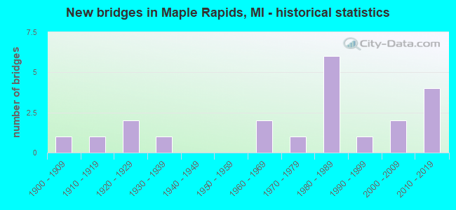
- New bridges - historical statistics
- 11900-1909
- 11910-1919
- 21920-1929
- 11930-1939
- 21960-1969
- 11970-1979
- 61980-1989
- 11990-1999
- 22000-2009
- 42010-2019

- Reconstructed bridges - Historical Statistics
- 41970-1979
- 11980-1989

- Bridge Condition - Deck
- 26.7%Very good
- 26.7%Good
- 26.7%Satisfactory
- 13.3%Fair
- 6.7%Serious

- Bridge Condition - Superstructure
- 20.0%Very good
- 26.7%Good
- 26.7%Satisfactory
- 20.0%Fair
- 6.7%Serious

- Bridge Condition - Substructure
- 20.0%Very good
- 26.7%Good
- 13.3%Satisfactory
- 26.7%Fair
- 13.3%Poor

- Bridge Condition - Channel
- 23.8%Very good
- 9.5%Good
- 23.8%Satisfactory
- 38.1%Fair
- 4.8%Poor

- Bridge Condition - Culverts
- 33.3%Very good
- 16.7%Good
- 16.7%Satisfactory
- 16.7%Fair
- 16.7%Poor
Find on map >> Show street view
Structure Number: 1909, Location: 1/4MI W OF ESSEX CENTER R (Lat: 43.046375, Lng: -84.662225), Route carried "on" structure: County highway , Year Built: 1965, Status: Posted for load, Structure Length: 1.55m (5.09ft), Average Daily Traffic: 1,593 (year 2017), Truck Traffic: 2%, Average Future Daily Traffic: 1,800 (year 2037), Design Load: HS 20, Features Intersected: SO FORK OF HAYWORTH G.R., Facility Carried by Structure: COLONY ROAD
Minimum Vertical Clearance: 30.48m (100.00ft), Kilometerpoint: 14.259, Lanes on structure: 2, Owner: County Highway Agency, Approaching Roadway Width: 10.4m (34.1ft), Material/Design: Prestressed concrete, Design/Construction: Box Beam or Girders - Multiple, Number Of Spans In Main Unit: 1, Length of Maximum Span: 15.2m (49.9ft), Curb or Sidewalk Widths: Left: 0.2m (0.7ft), Right: 0.2m (0.7ft), Curb-To-Curb Width: 7.9m (25.9ft), Out-to-Out Width: 9.4m (30.8ft)
Condition: Deck: Good, Superstructure: Good, Substructure: Good, Channel: Satisfactory, Operating Rating: 35.0 metric tons, Method Used To Determine Operating Rating: Load and Resistance Factor Rating (LRFR) rating reported by rating factor(RF) method using HL-93 loadings, Inventory Rating: 26.9 metric tons, Method Used To Determine Inventory Rating: Load and Resistance Factor Rating (LRFR) rating reported by rating factor(RF) method using HL-93 loadings, Structural Evaluation: Equal to present minimum criteria, Deck Geometry: Meets minimum limits, Waterway Adequacy: Equal to present minimum criteria, Approach Roadway Alignment: Better than present minimum criteria, Bridge Posting: Required (Relationship of Operating Rating to Maximum Legal Load: 0.1 - 9.9% below), Designated Inspection Frequency: Every 24 months, Inspection Date: October 2020, Deck Structure Type: Concrete Precast Panels, Wearing Surface/Protective System: Wearing Surface: Bituminous, Membrane: Preformed Fabric
Find on map >> Show street view
Structure Number: 1911, Location: 1/4 MI E OF WRIGHT RD (Lat: 43.068669, Lng: -84.732392), Route carried "on" structure: County highway 1929, Year Built: 1938, Year Reconstructed: 1984, Status: Posted for load, Structure Length: 0.76m (2.49ft), Average Daily Traffic: 505 (year 2011), Truck Traffic: 2%, Average Future Daily Traffic: 912 (year 2031), Design Load: H 20, Features Intersected: MAPLE RIVER DRAIN, Facility Carried by Structure: STONE ROAD
Minimum Vertical Clearance: 30.48m (100.00ft), Kilometerpoint: 5.422, Lanes on structure: 2, Owner: County Highway Agency, Approaching Roadway Width: 12.2m (40.0ft), Material/Design: Concrete, Design/Construction: Tee Beam, Number Of Spans In Main Unit: 1, Length of Maximum Span: 6.7m (22.0ft), Curb-To-Curb Width: 8.2m (26.9ft), Out-to-Out Width: 8.5m (27.9ft)
Condition: Deck: Satisfactory, Superstructure: Fair, Substructure: Poor, Channel: Fair, Operating Rating: 35.3 metric tons, Method Used To Determine Operating Rating: Load Factor (LF) rating reported by rating factor (RF) method using MS18 loading, Inventory Rating: 21.4 metric tons, Method Used To Determine Inventory Rating: Load Factor (LF) rating reported by rating factor (RF) method using MS18 loading, Structural Evaluation: Meets minimum limits, Deck Geometry: Somewhat better than minimum adequacy, Waterway Adequacy: Equal to present minimum criteria, Approach Roadway Alignment: Somewhat better than minimum adequacy, Bridge Posting: Required (Relationship of Operating Rating to Maximum Legal Load: 0.1 - 9.9% below), Length Of Structure Improvement: 1.22m (4.00ft), Designated Inspection Frequency: Every 24 months, Inspection Date: October 2020, Bridge Improvement Cost: $169,000, Total Project Cost: $190,000, Deck Structure Type: Concrete Cast-file-Place, Wearing Surface/Protective System: Wearing Surface: Bituminous
Find on map >> Show street view
Structure Number: 1912, Location: 1/4 MI W OF MAPLE AVE (Lat: 43.118014, Lng: -84.695678), Route carried "on" structure: County highway , Year Built: 1985, Status: Open, Structure Length: 0.67m (2.20ft), Average Daily Traffic: 1,157 (year 2011), Truck Traffic: 2%, Average Future Daily Traffic: 2,090 (year 2031), Design Load: HS 20, Features Intersected: OVERFLOW PINE RIVER, Facility Carried by Structure: GRATIOT ROAD
Minimum Vertical Clearance: 30.48m (100.00ft), Kilometerpoint: 11.490, Lanes on structure: 2, Owner: County Highway Agency, Approaching Roadway Width: 10.4m (34.1ft), Material/Design: Concrete, Design/Construction: Culvert, Number Of Spans In Main Unit: 1, Length of Maximum Span: 6.7m (22.0ft)
Condition: Channel: Satisfactory, Culverts: Good, Operating Rating: 54.5 metric tons, Method Used To Determine Operating Rating: Field evaluation and documented engineering judgment, Inventory Rating: 32.7 metric tons, Method Used To Determine Inventory Rating: Field evaluation and documented engineering judgment, Structural Evaluation: Better than present minimum criteria, Waterway Adequacy: Equal to present minimum criteria, Approach Roadway Alignment: Equal to present minimum criteria, Designated Inspection Frequency: Every 24 months, Inspection Date: October 2020
Find on map >> Show street view
Structure Number: 1913, Location: 50' W OF MAPLE AVE (Lat: 43.118003, Lng: -84.691861), Route carried "on" structure: County highway , Year Built: 1980, Status: Open, Structure Length: 2.50m (8.20ft), Average Daily Traffic: 1,157 (year 2011), Truck Traffic: 2%, Average Future Daily Traffic: 2,090 (year 2031), Design Load: HS 20, Features Intersected: PINE RIVER, Facility Carried by Structure: GRATIOT RD
Minimum Vertical Clearance: 30.48m (100.00ft), Kilometerpoint: 11.800, Lanes on structure: 2, Owner: County Highway Agency, Approaching Roadway Width: 10.4m (34.1ft), Skew: 2 degrees, Material/Design: Prestressed concrete, Design/Construction: Box Beam or Girders - Multiple, Number Of Spans In Main Unit: 2, Length of Maximum Span: 12.5m (41.0ft), Curb-To-Curb Width: 9.4m (30.8ft), Out-to-Out Width: 9.4m (30.8ft)
Condition: Deck: Very good, Superstructure: Good, Substructure: Good, Channel: Satisfactory, Operating Rating: 55.6 metric tons, Method Used To Determine Operating Rating: Load Factor (LF), Inventory Rating: 33.3 metric tons, Method Used To Determine Inventory Rating: Load Factor (LF), Structural Evaluation: Better than present minimum criteria, Deck Geometry: Somewhat better than minimum adequacy, Waterway Adequacy: Better than present minimum criteria, Approach Roadway Alignment: Equal to present desirable criteria, Designated Inspection Frequency: Every 24 months, Inspection Date: October 2020, Deck Structure Type: Other, Wearing Surface/Protective System: Wearing Surface: Monolithic Concrete
Find on map >> Show street view
Structure Number: 1915, Location: BETWEEN ISLAND RDS (Lat: 43.087989, Lng: -84.758886), Route carried "on" structure: County highway 1923, Year Built: 1969, Status: Open, Structure Length: 5.82m (19.09ft), Average Daily Traffic: 1,454 (year 2010), Truck Traffic: 2%, Average Future Daily Traffic: 2,247 (year 2025), Design Load: HS 20, Features Intersected: MAPLE RIVER, Facility Carried by Structure: TALLMAN ROAD
Minimum Vertical Clearance: 30.48m (100.00ft), Kilometerpoint: 16.063, Lanes on structure: 2, Owner: County Highway Agency, Approaching Roadway Width: 10.4m (34.1ft), Skew: 2 degrees, Material/Design: Prestressed concrete, Design/Construction: Box Beam or Girders - Multiple, Number Of Spans In Main Unit: 3, Length of Maximum Span: 19.5m (64.0ft), Curb-To-Curb Width: 9.1m (29.9ft), Out-to-Out Width: 9.5m (31.2ft)
Condition: Deck: Serious, Superstructure: Serious, Substructure: Satisfactory, Channel: Satisfactory, Operating Rating: 54.9 metric tons, Method Used To Determine Operating Rating: Load Factor (LF), Inventory Rating: 33.0 metric tons, Method Used To Determine Inventory Rating: Load Factor (LF), Structural Evaluation: High priority of corrective action, Deck Geometry: Somewhat better than minimum adequacy, Waterway Adequacy: Equal to present minimum criteria, Approach Roadway Alignment: Equal to present desirable criteria, Designated Inspection Frequency: Every 12 months, Inspection Date: October 2021, Deck Structure Type: Concrete Cast-file-Place, Wearing Surface/Protective System: Wearing Surface: Bituminous
Find on map >> Show street view
Structure Number: 198, Location: 0.2 MI E OF BAUER RD (Lat: 43.090367, Lng: -84.710931), Route carried "on" structure: County highway , Year Built: 1924, Year Reconstructed: 1984, Status: Open, Structure Length: 1.82m (5.97ft), Average Daily Traffic: 180 (year 1979), Average Future Daily Traffic: 380 (year 2009), Design Load: HS 20, Features Intersected: HAYWORTH CREEK, Facility Carried by Structure: ISLAND ROAD
Minimum Vertical Clearance: 30.48m (100.00ft), Kilometerpoint: 0.689, Lanes on structure: 2, Owner: County Highway Agency, Approaching Roadway Width: 7.3m (24.0ft), Material/Design: Prestressed concrete, Design/Construction: Box Beam or Girders - Multiple, Number Of Spans In Main Unit: 1, Length of Maximum Span: 17.6m (57.7ft), Curb-To-Curb Width: 6.4m (21.0ft), Out-to-Out Width: 6.4m (21.0ft)
Condition: Deck: Satisfactory, Superstructure: Fair, Substructure: Fair, Channel: Fair, Operating Rating: 52.6 metric tons, Method Used To Determine Operating Rating: Load Factor (LF), Inventory Rating: 31.6 metric tons, Method Used To Determine Inventory Rating: Load Factor (LF), Structural Evaluation: Somewhat better than minimum adequacy, Deck Geometry: Meets minimum limits, Waterway Adequacy: Equal to present minimum criteria, Approach Roadway Alignment: Meets minimum limits, Length Of Structure Improvement: 2.44m (8.01ft), Designated Inspection Frequency: Every 24 months, Inspection Date: October 2021, Bridge Improvement Cost: $200,000, Roadway Improvement Cost: $20,000, Total Project Cost: $236,000, Deck Structure Type: Concrete Precast Panels
Find on map >> Show street view
Structure Number: 1981, Location: 0.4 MI W OF FOREST HILL (Lat: 43.090208, Lng: -84.691731), Route carried "on" structure: County highway , Year Built: 1981, Status: Open, Structure Length: 0.61m (2.00ft), Average Daily Traffic: 180 (year 1981), Average Future Daily Traffic: 325 (year 2009), Design Load: HS 20, Features Intersected: COX DRAIN, Facility Carried by Structure: ISLAND ROAD
Minimum Vertical Clearance: 30.48m (100.00ft), Kilometerpoint: 2.252, Lanes on structure: 2, Owner: County Highway Agency, Approaching Roadway Width: 6.1m (20.0ft), Material/Design: Steel, Design/Construction: Culvert, Number Of Spans In Main Unit: 2, Length of Maximum Span: 3.0m (9.8ft)
Condition: Channel: Fair, Culverts: Poor, Operating Rating: 89.7 metric tons, Method Used To Determine Operating Rating: Load and Resistance Factor Rating (LRFR) rating reported by rating factor(RF) method using HL-93 loadings, Inventory Rating: 69.0 metric tons, Method Used To Determine Inventory Rating: Load and Resistance Factor Rating (LRFR) rating reported by rating factor(RF) method using HL-93 loadings, Structural Evaluation: Meets minimum limits, Waterway Adequacy: High priority of corrective action, Approach Roadway Alignment: Meets minimum limits, Designated Inspection Frequency: Every 24 months, Inspection Date: October 2021
Find on map >> Show street view
Structure Number: 1982, Location: 0.1 W OF FOREST HILL RD (Lat: 43.090081, Lng: -84.682283), Route carried "on" structure: County highway , Year Built: 1981, Status: Open, Structure Length: 0.61m (2.00ft), Average Daily Traffic: 180 (year 1981), Average Future Daily Traffic: 325 (year 2009), Design Load: HS 20, Features Intersected: COX DRAIN, Facility Carried by Structure: ISLAND ROAD
Minimum Vertical Clearance: 30.48m (100.00ft), Kilometerpoint: 3.021, Lanes on structure: 2, Owner: County Highway Agency, Approaching Roadway Width: 6.1m (20.0ft), Material/Design: Steel, Design/Construction: Culvert, Number Of Spans In Main Unit: 2, Length of Maximum Span: 3.0m (9.8ft)
Condition: Channel: Fair, Culverts: Satisfactory, Operating Rating: 76.8 metric tons, Method Used To Determine Operating Rating: Load and Resistance Factor Rating (LRFR) rating reported by rating factor(RF) method using HL-93 loadings, Inventory Rating: 59.3 metric tons, Method Used To Determine Inventory Rating: Load and Resistance Factor Rating (LRFR) rating reported by rating factor(RF) method using HL-93 loadings, Structural Evaluation: Equal to present minimum criteria, Waterway Adequacy: Equal to present minimum criteria, Approach Roadway Alignment: Equal to present minimum criteria, Designated Inspection Frequency: Every 24 months, Inspection Date: October 2021
Find on map >> Show street view
Structure Number: 1983, Location: 0.4 MI W OF WACOUSTA RD (Lat: 43.097647, Lng: -84.709492), Route carried "on" structure: County highway , Year Built: 1910, Year Reconstructed: 1983, Status: Open, Structure Length: 1.82m (5.97ft), Average Daily Traffic: 102 (year 2011), Average Future Daily Traffic: 184 (year 2031), Design Load: HS 20, Features Intersected: HAYWORTH CREEK, Facility Carried by Structure: HYDE ROAD
Minimum Vertical Clearance: 30.48m (100.00ft), Kilometerpoint: 1.017, Lanes on structure: 2, Owner: County Highway Agency, Approaching Roadway Width: 6.7m (22.0ft), Material/Design: Prestressed concrete, Design/Construction: Box Beam or Girders - Multiple, Number Of Spans In Main Unit: 1, Length of Maximum Span: 17.9m (58.7ft), Curb-To-Curb Width: 5.5m (18.0ft), Out-to-Out Width: 5.5m (18.0ft)
Condition: Deck: Satisfactory, Superstructure: Satisfactory, Substructure: Fair, Channel: Poor, Operating Rating: 51.9 metric tons, Method Used To Determine Operating Rating: Load Factor (LF), Inventory Rating: 31.1 metric tons, Method Used To Determine Inventory Rating: Load Factor (LF), Structural Evaluation: Somewhat better than minimum adequacy, Deck Geometry: High priority of corrective action, Waterway Adequacy: Equal to present minimum criteria, Approach Roadway Alignment: Meets minimum limits, Designated Inspection Frequency: Every 24 months, Inspection Date: October 2021, Deck Structure Type: Concrete Precast Panels
Find on map >> Show street view
Structure Number: 1986, Location: 0.8 MI N OF STONE RD (Lat: 43.079467, Lng: -84.719436), Route carried "on" structure: County highway , Year Built: 1906, Year Reconstructed: 1985, Status: Open, Structure Length: 1.82m (5.97ft), Average Daily Traffic: 102 (year 2011), Average Future Daily Traffic: 184 (year 2031), Design Load: HS 20, Features Intersected: HAYWORTH CREEK, Facility Carried by Structure: BAUER ROAD
Minimum Vertical Clearance: 30.48m (100.00ft), Kilometerpoint: 11.864, Lanes on structure: 2, Owner: County Highway Agency, Approaching Roadway Width: 5.5m (18.0ft), Material/Design: Prestressed concrete, Design/Construction: Box Beam or Girders - Multiple, Number Of Spans In Main Unit: 1, Length of Maximum Span: 17.0m (55.8ft), Curb-To-Curb Width: 5.5m (18.0ft), Out-to-Out Width: 5.5m (18.0ft)
Condition: Deck: Satisfactory, Superstructure: Satisfactory, Substructure: Poor, Channel: Fair, Operating Rating: 68.2 metric tons, Method Used To Determine Operating Rating: Load Factor (LF), Inventory Rating: 40.9 metric tons, Method Used To Determine Inventory Rating: Load Factor (LF), Structural Evaluation: Meets minimum limits, Deck Geometry: High priority of corrective action, Waterway Adequacy: Equal to present minimum criteria, Approach Roadway Alignment: High priority of corrective action, Designated Inspection Frequency: Every 24 months, Inspection Date: October 2021, Deck Structure Type: Concrete Precast Panels
Find on map >> Show street view
Structure Number: 1987, Location: 0.1 MI N OF MOSS RD (Lat: 43.083386, Lng: -84.719378), Route carried "on" structure: County highway , Year Built: 2004, Status: Open, Structure Length: 2.62m (8.60ft), Average Daily Traffic: 173 (year 2004), Average Future Daily Traffic: 250 (year 2023), Design Load: HS 25 or greater, Features Intersected: HAYWORTH CREEK, Facility Carried by Structure: BAUER ROAD
Minimum Vertical Clearance: 30.48m (100.00ft), Kilometerpoint: 12.301, Lanes on structure: 2, Owner: County Highway Agency, Approaching Roadway Width: 8.5m (27.9ft), Material/Design: Prestressed concrete, Design/Construction: Box Beam or Girders - Multiple, Number Of Spans In Main Unit: 1, Length of Maximum Span: 25.8m (84.6ft), Curb-To-Curb Width: 8.8m (28.9ft), Out-to-Out Width: 9.5m (31.2ft)
Condition: Deck: Very good, Superstructure: Good, Substructure: Very good, Channel: Very good, Operating Rating: 75.4 metric tons, Method Used To Determine Operating Rating: Load Factor (LF), Inventory Rating: 45.2 metric tons, Method Used To Determine Inventory Rating: Load Factor (LF), Structural Evaluation: Better than present minimum criteria, Deck Geometry: Equal to present minimum criteria, Waterway Adequacy: Somewhat better than minimum adequacy, Approach Roadway Alignment: Somewhat better than minimum adequacy, Designated Inspection Frequency: Every 24 months, Inspection Date: October 2021, Deck Structure Type: Concrete Cast-file-Place, Wearing Surface/Protective System: Wearing Surface: Integral Concrete, Deck Protection: Epoxy Coated Reinforcing
Find on map >> Show street view
Structure Number: 1988, Location: 0.3 MI S OF STONE RD (Lat: 43.059228, Lng: -84.700436), Route carried "on" structure: County highway , Year Built: 2007, Status: Open, Structure Length: 1.83m (6.00ft), Average Daily Traffic: 441 (year 2011), Average Future Daily Traffic: 796 (year 2031), Design Load: HS 20, Features Intersected: PEET CREEK, Facility Carried by Structure: WACOUSTA ROAD
Minimum Vertical Clearance: 30.48m (100.00ft), Kilometerpoint: 3.013, Lanes on structure: 2, Owner: County Highway Agency, Approaching Roadway Width: 10.4m (34.1ft), Material/Design: Prestressed concrete, Design/Construction: Box Beam or Girders - Multiple, Number Of Spans In Main Unit: 1, Length of Maximum Span: 17.1m (56.1ft), Curb-To-Curb Width: 8.8m (28.9ft), Out-to-Out Width: 9.6m (31.5ft)
Condition: Deck: Good, Superstructure: Good, Substructure: Very good, Channel: Very good, Operating Rating: 61.7 metric tons, Method Used To Determine Operating Rating: Load Factor (LF), Inventory Rating: 37.0 metric tons, Method Used To Determine Inventory Rating: Load Factor (LF), Structural Evaluation: Better than present minimum criteria, Deck Geometry: Somewhat better than minimum adequacy, Waterway Adequacy: Equal to present minimum criteria, Approach Roadway Alignment: Equal to present minimum criteria, Designated Inspection Frequency: Every 24 months, Inspection Date: October 2021, Deck Structure Type: Concrete Cast-file-Place, Wearing Surface/Protective System: Wearing Surface: Integral Concrete, Deck Protection: Epoxy Coated Reinforcing
Find on map >> Show street view
Structure Number: 1989, Location: 0.1 MI S OF COLONY RD (Lat: 43.045914, Lng: -84.660908), Route carried "on" structure: County highway , Year Built: 1920, Year Reconstructed: 1982, Status: Open, Structure Length: 1.25m (4.10ft), Average Daily Traffic: 100 (year 2011), Average Future Daily Traffic: 181 (year 2031), Design Load: HS 20, Features Intersected: S FORK OF HAYWORTH CREEK, Facility Carried by Structure: ESSEX CENTER ROAD
Minimum Vertical Clearance: 30.48m (100.00ft), Kilometerpoint: 1.566, Lanes on structure: 2, Owner: County Highway Agency, Approaching Roadway Width: 7.3m (24.0ft), Material/Design: Prestressed concrete, Design/Construction: Box Beam or Girders - Multiple, Number Of Spans In Main Unit: 1, Length of Maximum Span: 12.2m (40.0ft), Curb-To-Curb Width: 6.4m (21.0ft), Out-to-Out Width: 6.4m (21.0ft)
Condition: Deck: Fair, Superstructure: Satisfactory, Substructure: Fair, Channel: Fair, Operating Rating: 58.6 metric tons, Method Used To Determine Operating Rating: Load Factor (LF) rating reported by rating factor (RF) method using MS18 loading, Inventory Rating: 35.0 metric tons, Method Used To Determine Inventory Rating: Load Factor (LF) rating reported by rating factor (RF) method using MS18 loading, Structural Evaluation: Somewhat better than minimum adequacy, Deck Geometry: Somewhat better than minimum adequacy, Waterway Adequacy: Equal to present minimum criteria, Approach Roadway Alignment: Meets minimum limits, Length Of Structure Improvement: 1.52m (4.99ft), Designated Inspection Frequency: Every 24 months, Inspection Date: October 2021, Bridge Improvement Cost: $176,000, Roadway Improvement Cost: $16,000, Total Project Cost: $202,000, Deck Structure Type: Concrete Precast Panels
Find on map >> Show street view
Structure Number: 199, Location: 0.3 MI N OF COLONY RD (Lat: 43.049392, Lng: -84.660806), Route carried "on" structure: County highway , Year Built: 1970, Status: Open, Structure Length: 1.15m (3.77ft), Average Daily Traffic: 100 (year 2011), Average Future Daily Traffic: 181 (year 2031), Design Load: HS 20, Features Intersected: HAYWORTH CREEK, Facility Carried by Structure: ESSEX CENTER ROAD
Minimum Vertical Clearance: 30.48m (100.00ft), Kilometerpoint: 1.952, Lanes on structure: 2, Owner: County Highway Agency, Approaching Roadway Width: 8.5m (27.9ft), Material/Design: Prestressed concrete, Design/Construction: Tee Beam, Number Of Spans In Main Unit: 1, Length of Maximum Span: 11.2m (36.7ft), Curb-To-Curb Width: 6.1m (20.0ft), Out-to-Out Width: 6.7m (22.0ft)
Condition: Deck: Fair, Superstructure: Fair, Substructure: Fair, Channel: Fair, Operating Rating: 59.4 metric tons, Method Used To Determine Operating Rating: Load Factor (LF), Inventory Rating: 35.6 metric tons, Method Used To Determine Inventory Rating: Load Factor (LF), Structural Evaluation: Somewhat better than minimum adequacy, Deck Geometry: Somewhat better than minimum adequacy, Waterway Adequacy: Equal to present minimum criteria, Approach Roadway Alignment: Better than present minimum criteria, Designated Inspection Frequency: Every 24 months, Inspection Date: October 2021, Deck Structure Type: Concrete Precast Panels
Find on map >> Show street view
Structure Number: 1991, Location: 0.3 MI N OF PAXTON RD (Lat: 43.058017, Lng: -84.650800), Route carried "on" structure: County highway , Year Built: 2011, Status: Open, Structure Length: 1.65m (5.41ft), Average Daily Traffic: 94 (year 2005), Truck Traffic: 1%, Average Future Daily Traffic: 170 (year 2025), Design Load: Greater than HL93, Features Intersected: HAYWORTH CREEK, Facility Carried by Structure: ANDERSON ROAD
Minimum Vertical Clearance: 30.48m (100.00ft), Kilometerpoint: 1.302, Lanes on structure: 2, Owner: County Highway Agency, Approaching Roadway Width: 8.0m (26.2ft), Material/Design: Prestressed concrete, Design/Construction: Box Beam or Girders - Multiple, Number Of Spans In Main Unit: 1, Length of Maximum Span: 15.7m (51.5ft), Curb-To-Curb Width: 8.0m (26.2ft), Out-to-Out Width: 8.8m (28.9ft)
Condition: Deck: Very good, Superstructure: Very good, Substructure: Good, Channel: Good, Operating Rating: 83.3 metric tons, Method Used To Determine Operating Rating: Load and Resistance Factor Rating (LRFR) rating reported by rating factor(RF) method using HL-93 loadings, Inventory Rating: 64.2 metric tons, Method Used To Determine Inventory Rating: Load and Resistance Factor Rating (LRFR) rating reported by rating factor(RF) method using HL-93 loadings, Structural Evaluation: Better than present minimum criteria, Deck Geometry: Equal to present minimum criteria, Waterway Adequacy: Better than present minimum criteria, Approach Roadway Alignment: Better than present minimum criteria, Designated Inspection Frequency: Every 24 months, Inspection Date: October 2020, Deck Structure Type: Concrete Cast-file-Place, Wearing Surface/Protective System: Wearing Surface: Monolithic Concrete, Deck Protection: Galvanized Reinforcing
Find on map >> Show street view
Structure Number: 1992, Location: 0.1 MI N OF COLONY RD (Lat: 43.047653, Lng: -84.650953), Route carried "on" structure: County highway , Year Built: 1980, Status: Open, Structure Length: 0.70m (2.30ft), Average Daily Traffic: 106 (year 2011), Average Future Daily Traffic: 191 (year 2031), Design Load: HS 20, Features Intersected: S FORK OF HAYWORTH CREEK, Facility Carried by Structure: ANDERSON ROAD
Minimum Vertical Clearance: 30.48m (100.00ft), Kilometerpoint: 0.151, Lanes on structure: 2, Owner: County Highway Agency, Approaching Roadway Width: 10.4m (34.1ft), Material/Design: Steel, Design/Construction: Culvert, Number Of Spans In Main Unit: 2, Length of Maximum Span: 3.6m (11.8ft)
Condition: Channel: Fair, Culverts: Fair, Operating Rating: 61.6 metric tons, Method Used To Determine Operating Rating: Load and Resistance Factor Rating (LRFR) rating reported by rating factor(RF) method using HL-93 loadings, Inventory Rating: 47.6 metric tons, Method Used To Determine Inventory Rating: Load and Resistance Factor Rating (LRFR) rating reported by rating factor(RF) method using HL-93 loadings, Structural Evaluation: Somewhat better than minimum adequacy, Waterway Adequacy: Better than present minimum criteria, Approach Roadway Alignment: Meets minimum limits, Designated Inspection Frequency: Every 24 months, Inspection Date: October 2021
Find on map >> Show street view
Structure Number: 1993, Location: 0.5 MI N OF DAXTON RD (Lat: 43.060694, Lng: -84.630872), Route carried "on" structure: County highway , Year Built: 2015, Status: Open, Structure Length: 1.58m (5.18ft), Average Daily Traffic: 140 (year 2014), Truck Traffic: 2%, Average Future Daily Traffic: 250 (year 2034), Design Load: Greater than HL93, Features Intersected: HAYWORTH CREEK, Facility Carried by Structure: FINDLAY RD
Minimum Vertical Clearance: 30.48m (100.00ft), Kilometerpoint: 0.803, Lanes on structure: 2, Owner: County Highway Agency, Approaching Roadway Width: 8.5m (27.9ft), Material/Design: Prestressed concrete, Design/Construction: Box Beam or Girders - Multiple, Number Of Spans In Main Unit: 1, Length of Maximum Span: 15.5m (50.9ft), Curb-To-Curb Width: 8.7m (28.5ft), Out-to-Out Width: 9.7m (31.8ft)
Condition: Deck: Good, Superstructure: Very good, Substructure: Very good, Channel: Very good, Operating Rating: 69.3 metric tons, Method Used To Determine Operating Rating: Load and Resistance Factor Rating (LRFR) rating reported by rating factor(RF) method using HL-93 loadings, Inventory Rating: 53.5 metric tons, Method Used To Determine Inventory Rating: Load and Resistance Factor Rating (LRFR) rating reported by rating factor(RF) method using HL-93 loadings, Structural Evaluation: Equal to present desirable criteria, Deck Geometry: Equal to present minimum criteria, Waterway Adequacy: Superior to present desirable criteria, Approach Roadway Alignment: Equal to present minimum criteria, Designated Inspection Frequency: Every 24 months, Inspection Date: October 2021, Deck Structure Type: Concrete Cast-file-Place, Wearing Surface/Protective System: Wearing Surface: Monolithic Concrete, Deck Protection: Epoxy Coated Reinforcing
Find on map >> Show street view
Structure Number: 2028, Location: IN MAPLE RAPIDS (Lat: 43.109164, Lng: -84.693347), Route carried "on" structure: County highway 1929, Year Built: 1980, Status: Open, Structure Length: 4.20m (13.78ft), Average Daily Traffic: 2,890 (year 2007), Average Future Daily Traffic: 4,000 (year 2027), Design Load: HS 20, Features Intersected: MAPLE RIVER, Facility Carried by Structure: N MAPLE STREET
Minimum Vertical Clearance: 30.48m (100.00ft), Kilometerpoint: 2.126, Lanes on structure: 2, Owner: City or Municipal Highway Agency, Approaching Roadway Width: 9.1m (29.9ft), Skew: 3 degrees, Material/Design: Prestressed concrete, Design/Construction: Box Beam or Girders - Multiple, Number Of Spans In Main Unit: 3, Length of Maximum Span: 14.0m (45.9ft), Curb-To-Curb Width: 9.1m (29.9ft), Out-to-Out Width: 9.3m (30.5ft)
Condition: Deck: Good, Superstructure: Satisfactory, Substructure: Satisfactory, Channel: Satisfactory, Operating Rating: 56.7 metric tons, Method Used To Determine Operating Rating: Load and Resistance Factor Rating (LRFR) rating reported by rating factor(RF) method using HL-93 loadings, Inventory Rating: 43.7 metric tons, Method Used To Determine Inventory Rating: Load and Resistance Factor Rating (LRFR) rating reported by rating factor(RF) method using HL-93 loadings, Structural Evaluation: Equal to present minimum criteria, Deck Geometry: Meets minimum limits, Waterway Adequacy: Equal to present minimum criteria, Approach Roadway Alignment: Equal to present minimum criteria, Designated Inspection Frequency: Every 24 months, Inspection Date: October 2020, Deck Structure Type: Other, Wearing Surface/Protective System: Wearing Surface: Bituminous
Find on map >> Show street view
Structure Number: 3157, Location: SEC 30 FULTON TWP (Lat: 43.146089, Lng: -84.709128), Route carried "on" structure: County highway , Year Built: 1990, Status: Open, Structure Length: 2.28m (7.48ft), Average Daily Traffic: 1,445 (year 2003), Average Future Daily Traffic: 1,950 (year 2023), Design Load: HS 20+Mod, Features Intersected: DRAIN #163, Facility Carried by Structure: ELY HIGHWAY
Minimum Vertical Clearance: 30.48m (100.00ft), Kilometerpoint: 3.113, Lanes on structure: 2, Owner: County Highway Agency, Approaching Roadway Width: 10.1m (33.1ft), Material/Design: Prestressed concrete, Design/Construction: Stringer/Multi-beam, Number Of Spans In Main Unit: 1, Length of Maximum Span: 22.8m (74.8ft), Curb-To-Curb Width: 10.1m (33.1ft), Out-to-Out Width: 11.1m (36.4ft)
Condition: Deck: Very good, Superstructure: Very good, Substructure: Good, Channel: Very good, Operating Rating: 80.4 metric tons, Method Used To Determine Operating Rating: Load Factor (LF), Inventory Rating: 48.2 metric tons, Method Used To Determine Inventory Rating: Load Factor (LF), Structural Evaluation: Better than present minimum criteria, Deck Geometry: Somewhat better than minimum adequacy, Waterway Adequacy: Equal to present desirable criteria, Approach Roadway Alignment: Equal to present desirable criteria, Designated Inspection Frequency: Every 24 months, Inspection Date: June 2021, Deck Structure Type: Concrete Cast-file-Place, Wearing Surface/Protective System: Wearing Surface: Bituminous, Deck Protection: Other Coated Reinforcing
Find on map >> Show street view
Structure Number: 32, Location: SEC 19-30 FULTON TWP (Lat: 43.147206, Lng: -84.711092), Route carried "on" structure: County highway , Year Built: 2016, Status: Open, Structure Length: 0.77m (2.53ft), Average Daily Traffic: 114 (year 2015), Truck Traffic: 5%, Average Future Daily Traffic: 170 (year 2035), Design Load: Greater than HL93, Features Intersected: DRAIN #49, Facility Carried by Structure: TAFT ROAD
Minimum Vertical Clearance: 30.48m (100.00ft), Kilometerpoint: 3.877, Lanes on structure: 2, Owner: County Highway Agency, Approaching Roadway Width: 9.1m (29.9ft), Skew: 1 degrees, Material/Design: Concrete, Design/Construction: Culvert, Number Of Spans In Main Unit: 1, Length of Maximum Span: 7.1m (23.3ft), Curb-To-Curb Width: 9.1m (29.9ft), Out-to-Out Width: 17.7m (58.1ft)
Condition: Channel: Very good, Culverts: Very good, Operating Rating: 48.3 metric tons, Method Used To Determine Operating Rating: Load and Resistance Factor Rating (LRFR) rating reported by rating factor(RF) method using HL-93 loadings, Inventory Rating: 37.3 metric tons, Method Used To Determine Inventory Rating: Load and Resistance Factor Rating (LRFR) rating reported by rating factor(RF) method using HL-93 loadings, Structural Evaluation: Equal to present desirable criteria, Deck Geometry: Equal to present minimum criteria, Waterway Adequacy: Better than present minimum criteria, Approach Roadway Alignment: Somewhat better than minimum adequacy, Length Of Structure Improvement: 1.22m (4.00ft), Designated Inspection Frequency: Every 24 months, Inspection Date: July 2020, Bridge Improvement Cost: $92,000, Roadway Improvement Cost: $20,000, Total Project Cost: $140,000, Wearing Surface/Protective System: Wearing Surface: Bituminous
Find on map >> Show street view
Structure Number: 13124, Location: FULTON TWP SEC 19 (Lat: 43.147164, Lng: -84.705053), Route carried "on" structure: County highway , Year Built: 2012, Status: Open, Structure Length: 0.80m (2.62ft), Average Daily Traffic: 92 (year 2012), Truck Traffic: 5%, Average Future Daily Traffic: 135 (year 2032), Design Load: Greater than HL93, Features Intersected: OTTER CREEK, Facility Carried by Structure: TAFT ROAD
Minimum Vertical Clearance: 9.96m (32.68ft), Kilometerpoint: 4.368, Lanes on structure: 2, Owner: County Highway Agency, Approaching Roadway Width: 9.1m (29.9ft), Material/Design: Concrete, Design/Construction: Culvert, Number Of Spans In Main Unit: 1, Length of Maximum Span: 7.4m (24.3ft), Curb-To-Curb Width: 9.1m (29.9ft), Out-to-Out Width: 14.6m (47.9ft)
Condition: Channel: Good, Culverts: Very good, Operating Rating: 60.6 metric tons, Method Used To Determine Operating Rating: Load and Resistance Factor Rating (LRFR) rating reported by rating factor(RF) method using HL-93 loadings, Inventory Rating: 46.7 metric tons, Method Used To Determine Inventory Rating: Load and Resistance Factor Rating (LRFR) rating reported by rating factor(RF) method using HL-93 loadings, Structural Evaluation: Equal to present desirable criteria, Deck Geometry: Better than present minimum criteria, Waterway Adequacy: Better than present minimum criteria, Approach Roadway Alignment: Equal to present minimum criteria, Designated Inspection Frequency: Every 24 months, Inspection Date: July 2020, Wearing Surface/Protective System: Wearing Surface: Bituminous