Bridge Statistics for Manzanola, Colorado (CO)
Condition, Traffic, Stress, Structural Evaluation, Project Costs
- National Bridge Inventory (NBI) Statistics
- 23Number of bridges
- 164ft / 50.1mTotal length
- 20,198Total average daily traffic
- 1,850Total average daily truck traffic
- 22,104Total future (year 2038) average daily traffic
- National Bridge Inventory (NBI) Registered Bridges for Manzanola
- No street view available for this location
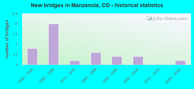
- New bridges - historical statistics
- 41950-1959
- 101960-1969
- 11970-1979
- 31980-1989
- 21990-1999
- 22000-2009
- 12020-2022


- Bridge Condition - Deck
- 5.0%Very good
- 30.0%Good
- 35.0%Satisfactory
- 15.0%Fair
- 15.0%Poor

- Bridge Condition - Superstructure
- 15.0%Very good
- 10.0%Good
- 40.0%Satisfactory
- 30.0%Fair
- 5.0%Poor

- Bridge Condition - Substructure
- 30.0%Good
- 50.0%Satisfactory
- 15.0%Fair
- 5.0%Poor

- Bridge Condition - Channel
- 19.0%Very good
- 42.9%Good
- 38.1%Satisfactory

- Bridge Condition - Culverts
- 33.3%Very good
- 33.3%Good
- 33.3%Satisfactory
Find on map >> Show street view
Structure Number: BEATY BRIDGE, Location: .1 MI N OF US 50 (Lat: 38.107639, Lng: -103.863833), Route carried "on" structure: City street _, Year Built: 2021, Status: Posted for load-capacity, Structure Length: 0.86m (2.82ft), Average Daily Traffic: 117 (year 2018), Average Future Daily Traffic: 171 (year 2038), Design Load: HL 93, Features Intersected: CATLIN CANAL, Facility Carried by Structure: N BEATY AVENUE
Minimum Vertical Clearance: 30+ m (98+ ft), Kilometerpoint: 0.000, Lanes on structure: 2, Owner: Town or Township Highway Agency, Approaching Roadway Width: 7.3m (24.0ft), Skew: 2 degrees, Material/Design: Concrete, Design/Construction: Culvert, Number Of Spans In Main Unit: 1, Length of Maximum Span: 8.6m (28.2ft), Curb-To-Curb Width: 7.3m (24.0ft), Out-to-Out Width: 8.2m (26.9ft)
Condition: Channel: Good, Culverts: Very good, Operating Rating: 28.5 metric tons, Method Used To Determine Operating Rating: Load and Resistance Factor Rating (LRFR) rating reported by rating factor(RF) method using HL-93 loadings, Inventory Rating: 21.7 metric tons, Method Used To Determine Inventory Rating: Load and Resistance Factor Rating (LRFR) rating reported by rating factor(RF) method using HL-93 loadings, Structural Evaluation: Equal to present minimum criteria, Deck Geometry: Somewhat better than minimum adequacy, Waterway Adequacy: Equal to present desirable criteria, Approach Roadway Alignment: Equal to present desirable criteria, Bridge Posting: Required (Relationship of Operating Rating to Maximum Legal Load: 0.1 - 9.9% below), Designated Inspection Frequency: Every 24 months, Inspection Date: November 2021
Find on map >> Show street view
Structure Number: L-21-BK, Location: IN MANZANOLA (Lat: 38.108358, Lng: -103.866325), Route carried "on" structure: State highway 207A, Year Built: 1963, Status: Open, Structure Length: 0.66m (2.17ft), Average Daily Traffic: 1,200 (year 2020), Truck Traffic: 4%, Average Future Daily Traffic: 1,308 (year 2040), Design Load: HS 20, Features Intersected: CATLIN CANAL, Facility Carried by Structure: SH 207 ML
Minimum Vertical Clearance: 30+ m (98+ ft), Kilometerpoint: 0.080, Lanes on structure: 2, Owner: State Highway Agency, Approaching Roadway Width: 18.3m (60.0ft), Skew: 2 degrees, Material/Design: Concrete, Design/Construction: Culvert, Number Of Spans In Main Unit: 1, Length of Maximum Span: 6.1m (20.0ft), Curb or Sidewalk Widths: Left: 1.5m (4.9ft), Right: 1.5m (4.9ft), Curb-To-Curb Width: 18.3m (60.0ft), Out-to-Out Width: 21.3m (69.9ft)
Condition: Channel: Very good, Culverts: Good, Operating Rating: 36.3 metric tons, Method Used To Determine Operating Rating: Field evaluation and documented engineering judgment, Inventory Rating: 32.7 metric tons, Method Used To Determine Inventory Rating: Field evaluation and documented engineering judgment, Structural Evaluation: Better than present minimum criteria, Deck Geometry: Superior to present desirable criteria, Waterway Adequacy: Equal to present desirable criteria, Approach Roadway Alignment: Equal to present desirable criteria, Designated Inspection Frequency: Every 24 months, Inspection Date: Febuary 2020
Find on map >> Show street view
Structure Number: L-21-CT, Location: 2 MI WEST OF ROCKY FORD (Lat: 38.055075, Lng: -103.763094), Route carried "on" structure: State highway 202A, Year Built: 1951, Status: Open, Structure Length: 0.87m (2.85ft), Average Daily Traffic: 180 (year 2020), Truck Traffic: 7%, Average Future Daily Traffic: 221 (year 2040), Design Load: H 20, Features Intersected: OTERO CANAL, Facility Carried by Structure: SH 202 ML
Minimum Vertical Clearance: 30+ m (98+ ft), Kilometerpoint: 3.307, Lanes on structure: 2, Owner: State Highway Agency, Approaching Roadway Width: 6.7m (22.0ft), Skew: 1 degrees, Material/Design: Wood or Timber, Design/Construction: Stringer/Multi-beam, Number Of Spans In Main Unit: 1, Length of Maximum Span: 8.3m (27.2ft), Curb-To-Curb Width: 7.3m (24.0ft), Out-to-Out Width: 7.6m (24.9ft)
Condition: Deck: Satisfactory, Superstructure: Fair, Substructure: Satisfactory, Channel: Very good, Operating Rating: 43.6 metric tons, Method Used To Determine Operating Rating: Allowable Stress (AS), Inventory Rating: 30.0 metric tons, Method Used To Determine Inventory Rating: Allowable Stress (AS), Structural Evaluation: Somewhat better than minimum adequacy, Deck Geometry: Somewhat better than minimum adequacy, Waterway Adequacy: Equal to present desirable criteria, Approach Roadway Alignment: Equal to present desirable criteria, Designated Inspection Frequency: Every 24 months, Inspection Date: June 2020, Deck Structure Type: Wood or Timber, Wearing Surface/Protective System: Wearing Surface: Bituminous
Find on map >> Show street view
Structure Number: L-21-CW, Location: 1.5 MI E. OF MANZANOLA (Lat: 38.102525, Lng: -103.844031), Route carried "on" structure: US 50B, Year Built: 1969, Status: Open, Structure Length: 5.29m (17.36ft), Average Daily Traffic: 2,800 (year 2020), Truck Traffic: 11%, Average Future Daily Traffic: 2,940 (year 2040), Design Load: HS 20, Features Intersected: BNSF RR, Facility Carried by Structure: US 50 ML WBND
Minimum Vertical Clearance: 30+ m (98+ ft), Kilometerpoint: 73.087, Lanes on structure: 2, Base Highway Network: Yes, Owner: State Highway Agency, Approaching Roadway Width: 11.6m (38.1ft), Skew: 14 degrees, Material/Design: Steel continuous, Design/Construction: Stringer/Multi-beam, Number Of Spans In Main Unit: 3, Length of Maximum Span: 19.5m (64.0ft), Curb-To-Curb Width: 11.6m (38.1ft), Out-to-Out Width: 12.2m (40.0ft)
Condition: Deck: Fair, Superstructure: Satisfactory, Substructure: Satisfactory, Operating Rating: 51.7 metric tons, Method Used To Determine Operating Rating: Load Factor (LF), Inventory Rating: 31.0 metric tons, Method Used To Determine Inventory Rating: Load Factor (LF), Structural Evaluation: Equal to present minimum criteria, Deck Geometry: Better than present minimum criteria, Underclear: Equal to present minimum criteria, Approach Roadway Alignment: Better than present minimum criteria, Designated Inspection Frequency: Every 24 months, Inspection Date: January 2022, Deck Structure Type: Concrete Cast-file-Place, Wearing Surface/Protective System: Wearing Surface: Bituminous, Membrane: Built-up
Find on map >> Show street view
Structure Number: L-21-CX, Location: 1.5 MI EAST OF MANZANOLA (Lat: 38.102417, Lng: -103.843725), Route carried "on" structure: US 50B, Year Built: 1969, Status: Open, Structure Length: 5.28m (17.32ft), Average Daily Traffic: 2,800 (year 2020), Truck Traffic: 11%, Average Future Daily Traffic: 2,940 (year 2040), Design Load: HS 20, Features Intersected: BNSF RR, Facility Carried by Structure: US 50 ML EBND
Minimum Vertical Clearance: 30+ m (98+ ft), Kilometerpoint: 73.109, Lanes on structure: 2, Base Highway Network: Yes, Owner: State Highway Agency, Approaching Roadway Width: 11.6m (38.1ft), Skew: 14 degrees, Material/Design: Steel continuous, Design/Construction: Stringer/Multi-beam, Number Of Spans In Main Unit: 3, Length of Maximum Span: 19.5m (64.0ft), Curb-To-Curb Width: 11.6m (38.1ft), Out-to-Out Width: 12.3m (40.4ft)
Condition: Deck: Satisfactory, Superstructure: Satisfactory, Substructure: Satisfactory, Operating Rating: 56.4 metric tons, Method Used To Determine Operating Rating: Load Factor (LF), Inventory Rating: 33.8 metric tons, Method Used To Determine Inventory Rating: Load Factor (LF), Structural Evaluation: Equal to present minimum criteria, Deck Geometry: Better than present minimum criteria, Underclear: Better than present minimum criteria, Approach Roadway Alignment: Equal to present minimum criteria, Designated Inspection Frequency: Every 24 months, Inspection Date: January 2022, Deck Structure Type: Concrete Cast-file-Place, Wearing Surface/Protective System: Wearing Surface: Epoxy Overlay, Deck Protection: Epoxy Coated Reinforcing
Find on map >> Show street view
Structure Number: L-21-CY, Location: 1.4 MI N OF MANZANOLA (Lat: 38.126675, Lng: -103.861997), Route carried "on" structure: State highway 207A, Year Built: 1984, Status: Open, Structure Length: 14.66m (48.10ft), Average Daily Traffic: 1,200 (year 2020), Truck Traffic: 4%, Average Future Daily Traffic: 1,308 (year 2040), Design Load: HS 20+Mod, Features Intersected: ARKANSAS RIVER, Facility Carried by Structure: SH 207 ML
Minimum Vertical Clearance: 30+ m (98+ ft), Kilometerpoint: 2.173, Lanes on structure: 2, Owner: State Highway Agency, Approaching Roadway Width: 9.1m (29.9ft), Skew: 2 degrees, Material/Design: Prestressed concrete continuous, Design/Construction: Stringer/Multi-beam, Number Of Spans In Main Unit: 5, Length of Maximum Span: 29.2m (95.8ft), Curb-To-Curb Width: 10.4m (34.1ft), Out-to-Out Width: 11.1m (36.4ft)
Condition: Deck: Good, Superstructure: Very good, Substructure: Satisfactory, Channel: Good, Operating Rating: 64.6 metric tons, Method Used To Determine Operating Rating: Load Factor (LF), Inventory Rating: 38.6 metric tons, Method Used To Determine Inventory Rating: Load Factor (LF), Structural Evaluation: Equal to present minimum criteria, Deck Geometry: Equal to present minimum criteria, Waterway Adequacy: Equal to present desirable criteria, Approach Roadway Alignment: Equal to present desirable criteria, Designated Inspection Frequency: Every 48 months, Inspection Date: Febuary 2020, Deck Structure Type: Concrete Cast-file-Place, Wearing Surface/Protective System: Wearing Surface: Bituminous, Membrane: Preformed Fabric, Deck Protection: Epoxy Coated Reinforcing
Find on map >> Show street view
Structure Number: L-21-DB, Location: 7.5 MI EAST OF FOWLER (Lat: 38.114881, Lng: -103.888447), Route carried "on" structure: US 50B, Year Built: 1997, Status: Open, Structure Length: 3.57m (11.71ft), Average Daily Traffic: 4,700 (year 2020), Truck Traffic: 10%, Average Future Daily Traffic: 4,982 (year 2040), Design Load: HS 20, Features Intersected: SMITH HOLLOW, Facility Carried by Structure: US 50 ML
Minimum Vertical Clearance: 30+ m (98+ ft), Kilometerpoint: 68.877, Lanes on structure: 2, Base Highway Network: Yes, Owner: State Highway Agency, Approaching Roadway Width: 12.2m (40.0ft), Skew: 4 degrees, Material/Design: Prestressed concrete, Design/Construction: Stringer/Multi-beam, Number Of Spans In Main Unit: 1, Length of Maximum Span: 34.6m (113.5ft), Curb-To-Curb Width: 13.4m (44.0ft), Out-to-Out Width: 14.1m (46.3ft)
Condition: Deck: Good, Superstructure: Very good, Substructure: Good, Channel: Good, Operating Rating: 84.3 metric tons, Method Used To Determine Operating Rating: Load Factor (LF), Inventory Rating: 38.4 metric tons, Method Used To Determine Inventory Rating: Load Factor (LF), Structural Evaluation: Better than present minimum criteria, Deck Geometry: Better than present minimum criteria, Waterway Adequacy: Equal to present desirable criteria, Approach Roadway Alignment: Equal to present desirable criteria, Designated Inspection Frequency: Every 24 months, Inspection Date: January 2022, Deck Structure Type: Concrete Cast-file-Place, Wearing Surface/Protective System: Wearing Surface: Bituminous, Membrane: Preformed Fabric, Deck Protection: Epoxy Coated Reinforcing
Find on map >> Show street view
Structure Number: L-21-K, Location: 0.6 MI EAST OF MANZANOLA (Lat: 38.104175, Lng: -103.857050), Route carried "on" structure: US 50B, Year Built: 1969, Status: Open, Structure Length: 1.13m (3.71ft), Average Daily Traffic: 5,600 (year 2020), Truck Traffic: 11%, Average Future Daily Traffic: 5,880 (year 2040), Design Load: HS 20, Features Intersected: CATLIN CANAL, Facility Carried by Structure: US 50 ML
Minimum Vertical Clearance: 30+ m (98+ ft), Kilometerpoint: 71.904, Lanes on structure: 4, Base Highway Network: Yes, Owner: State Highway Agency, Approaching Roadway Width: 21.3m (69.9ft), Skew: 25 degrees, Material/Design: Concrete, Design/Construction: Culvert, Number Of Spans In Main Unit: 1, Length of Maximum Span: 11.3m (37.1ft), Out-to-Out Width: 42.7m (140.1ft)
Condition: Channel: Satisfactory, Culverts: Satisfactory, Operating Rating: 36.3 metric tons, Method Used To Determine Operating Rating: Field evaluation and documented engineering judgment, Inventory Rating: 32.7 metric tons, Method Used To Determine Inventory Rating: Field evaluation and documented engineering judgment, Structural Evaluation: Equal to present minimum criteria, Waterway Adequacy: Superior to present desirable criteria, Approach Roadway Alignment: Equal to present desirable criteria, Designated Inspection Frequency: Every 24 months, Inspection Date: January 2022
Find on map >> Show street view
Structure Number: OT-11-10-31-29, Location: 1.3 MI S OF SH 50 (Lat: 38.091556, Lng: -103.875611), Route carried "on" structure: County highway , Year Built: 1980, Status: Open, Structure Length: 0.96m (3.15ft), Average Daily Traffic: 184 (year 2018), Truck Traffic: 2%, Average Future Daily Traffic: 271 (year 2038), Features Intersected: ROCKY FORD HIGHLINE CANA, Facility Carried by Structure: COUNTY ROAD 11
Minimum Vertical Clearance: 30+ m (98+ ft), Kilometerpoint: 29.947, Lanes on structure: 2, Owner: County Highway Agency, Approaching Roadway Width: 6.2m (20.3ft), Skew: 4 degrees, Material/Design: Steel, Design/Construction: Stringer/Multi-beam, Number Of Spans In Main Unit: 1, Length of Maximum Span: 8.8m (28.9ft), Curb-To-Curb Width: 7.8m (25.6ft), Out-to-Out Width: 7.9m (25.9ft)
Condition: Deck: Satisfactory, Superstructure: Fair, Substructure: Satisfactory, Channel: Good, Operating Rating: 49.5 metric tons, Method Used To Determine Operating Rating: Load Factor (LF), Inventory Rating: 29.8 metric tons, Method Used To Determine Inventory Rating: Load Factor (LF), Structural Evaluation: Somewhat better than minimum adequacy, Deck Geometry: Somewhat better than minimum adequacy, Waterway Adequacy: Equal to present desirable criteria, Approach Roadway Alignment: Equal to present desirable criteria, Designated Inspection Frequency: Every 24 months, Inspection Date: November 2021, Deck Structure Type: Corrugated Steel, Wearing Surface/Protective System: Wearing Surface: Bituminous
Find on map >> Show street view
Structure Number: OT-11-10-32-027, Location: .1 MI N OF SH 50 (Lat: 38.110972, Lng: -103.873056), Route carried "on" structure: County highway , Year Built: 1950, Status: Open, Structure Length: 0.92m (3.02ft), Average Daily Traffic: 57 (year 2018), Average Future Daily Traffic: 84 (year 2038), Features Intersected: CATLIN CANAL, Facility Carried by Structure: COUNTY ROAD 11.25
Minimum Vertical Clearance: 30+ m (98+ ft), Kilometerpoint: 0.047, Lanes on structure: 1, Owner: County Highway Agency, Approaching Roadway Width: 5.2m (17.1ft), Material/Design: Steel, Design/Construction: Stringer/Multi-beam, Number Of Spans In Main Unit: 1, Length of Maximum Span: 8.2m (26.9ft), Curb-To-Curb Width: 4.8m (15.7ft), Out-to-Out Width: 4.9m (16.1ft)
Condition: Deck: Satisfactory, Superstructure: Satisfactory, Substructure: Poor, Channel: Satisfactory, Operating Rating: 53.3 metric tons, Method Used To Determine Operating Rating: Load Factor (LF), Inventory Rating: 31.9 metric tons, Method Used To Determine Inventory Rating: Load Factor (LF), Structural Evaluation: Meets minimum limits, Deck Geometry: Equal to present desirable criteria, Waterway Adequacy: Equal to present desirable criteria, Approach Roadway Alignment: Meets minimum limits, Designated Inspection Frequency: Every 24 months, Inspection Date: November 2021, Deck Structure Type: Wood or Timber, Wearing Surface/Protective System: Wearing Surface: Bituminous
Find on map >> Show street view
Structure Number: OT-9-08-322-024, Location: .1 MI S OF SH 50 (Lat: 38.116972, Lng: -103.912139), Route carried "on" structure: County highway , Year Built: 1966, Status: Open, Structure Length: 1.13m (3.71ft), Average Daily Traffic: 52 (year 2018), Average Future Daily Traffic: 76 (year 2038), Features Intersected: OTERO CANAL, Facility Carried by Structure: COUNTY ROAD 9
Minimum Vertical Clearance: 30+ m (98+ ft), Kilometerpoint: 1.287, Lanes on structure: 2, Owner: County Highway Agency, Approaching Roadway Width: 6.1m (20.0ft), Skew: 2 degrees, Material/Design: Steel, Design/Construction: Stringer/Multi-beam, Number Of Spans In Main Unit: 1, Length of Maximum Span: 7.0m (23.0ft), Curb-To-Curb Width: 6.4m (21.0ft), Out-to-Out Width: 6.4m (21.0ft)
Condition: Deck: Satisfactory, Superstructure: Satisfactory, Substructure: Satisfactory, Channel: Good, Operating Rating: 45.8 metric tons, Method Used To Determine Operating Rating: Load Factor (LF), Inventory Rating: 27.4 metric tons, Method Used To Determine Inventory Rating: Load Factor (LF), Structural Evaluation: Equal to present minimum criteria, Deck Geometry: Somewhat better than minimum adequacy, Waterway Adequacy: Equal to present desirable criteria, Approach Roadway Alignment: Equal to present desirable criteria, Designated Inspection Frequency: Every 24 months, Inspection Date: November 2021, Deck Structure Type: Concrete Cast-file-Place, Wearing Surface/Protective System: Wearing Surface: Bituminous
Find on map >> Show street view
Structure Number: OT10-10-32-B-M1, Location: .1 MI N OF SH 50 (Lat: 38.108861, Lng: -103.868778), Route carried "on" structure: City street , Year Built: 1976, Status: Posted for load, Structure Length: 0.93m (3.05ft), Average Daily Traffic: 187 (year 2018), Truck Traffic: 2%, Average Future Daily Traffic: 275 (year 2038), Features Intersected: CATLIN CANAL, Facility Carried by Structure: CANAL ROAD
Minimum Vertical Clearance: 30+ m (98+ ft), Kilometerpoint: 0.482, Lanes on structure: 2, Owner: Town or Township Highway Agency, Approaching Roadway Width: 7.3m (24.0ft), Material/Design: Steel, Design/Construction: Stringer/Multi-beam, Number Of Spans In Main Unit: 1, Length of Maximum Span: 8.6m (28.2ft), Curb-To-Curb Width: 7.5m (24.6ft), Out-to-Out Width: 7.5m (24.6ft)
Condition: Deck: Satisfactory, Superstructure: Satisfactory, Substructure: Satisfactory, Channel: Satisfactory, Operating Rating: 22.0 metric tons, Method Used To Determine Operating Rating: Load Factor (LF), Inventory Rating: 13.2 metric tons, Method Used To Determine Inventory Rating: Load Factor (LF), Structural Evaluation: Meets minimum limits, Deck Geometry: Somewhat better than minimum adequacy, Waterway Adequacy: Equal to present desirable criteria, Approach Roadway Alignment: Equal to present desirable criteria, Bridge Posting: Required (Relationship of Operating Rating to Maximum Legal Load: 30.0 - 39.9% below), Designated Inspection Frequency: Every 24 months, Inspection Date: November 2021, Deck Structure Type: Concrete Cast-file-Place, Wearing Surface/Protective System: Wearing Surface: Bituminous
Find on map >> Show street view
Structure Number: OT10-9-31.5-26A, Location: .8 MI S OF SH 50 (Lat: 38.105389, Lng: -103.894306), Route carried "on" structure: County highway , Year Built: 2003, Status: Open, Structure Length: 3.66m (12.01ft), Average Daily Traffic: 111 (year 2018), Truck Traffic: 2%, Average Future Daily Traffic: 164 (year 2038), Design Load: HS 25 or greater, Features Intersected: SMITH ARROYO, Facility Carried by Structure: COUNTY ROAD JJ.5
Minimum Vertical Clearance: 30+ m (98+ ft), Kilometerpoint: 1.595, Lanes on structure: 2, Owner: County Highway Agency, Approaching Roadway Width: 9.1m (29.9ft), Skew: 1 degrees, Material/Design: Prestressed concrete, Design/Construction: Stringer/Multi-beam, Number Of Spans In Main Unit: 1, Length of Maximum Span: 35.4m (116.1ft), Curb-To-Curb Width: 9.1m (29.9ft), Out-to-Out Width: 10.1m (33.1ft)
Condition: Deck: Good, Superstructure: Very good, Substructure: Good, Channel: Very good, Operating Rating: 69.9 metric tons, Method Used To Determine Operating Rating: Load Factor (LF), Inventory Rating: 42.0 metric tons, Method Used To Determine Inventory Rating: Load Factor (LF), Structural Evaluation: Better than present minimum criteria, Deck Geometry: Equal to present minimum criteria, Waterway Adequacy: Equal to present desirable criteria, Approach Roadway Alignment: Equal to present minimum criteria, Designated Inspection Frequency: Every 24 months, Inspection Date: November 2021, Deck Structure Type: Concrete Cast-file-Place, Wearing Surface/Protective System: Wearing Surface: Monolithic Concrete, Deck Protection: Epoxy Coated Reinforcing
Find on map >> Show street view
Structure Number: OT11-10-31.6-28, Location: .4 MI S OF SH 50 (Lat: 38.106778, Lng: -103.875556), Route carried "on" structure: County highway , Year Built: 1964, Status: Open, Structure Length: 0.91m (2.99ft), Average Daily Traffic: 199 (year 2018), Truck Traffic: 2%, Average Future Daily Traffic: 292 (year 2038), Features Intersected: OTERO CANAL, Facility Carried by Structure: COUNTY ROAD 11
Minimum Vertical Clearance: 30+ m (98+ ft), Kilometerpoint: 31.655, Lanes on structure: 2, Owner: County Highway Agency, Approaching Roadway Width: 6.7m (22.0ft), Skew: 3 degrees, Material/Design: Steel, Design/Construction: Stringer/Multi-beam, Number Of Spans In Main Unit: 1, Length of Maximum Span: 8.3m (27.2ft), Curb-To-Curb Width: 6.8m (22.3ft), Out-to-Out Width: 6.9m (22.6ft)
Condition: Deck: Poor, Superstructure: Fair, Substructure: Fair, Channel: Satisfactory, Operating Rating: 41.3 metric tons, Method Used To Determine Operating Rating: Load Factor (LF), Inventory Rating: 24.7 metric tons, Method Used To Determine Inventory Rating: Load Factor (LF), Structural Evaluation: Somewhat better than minimum adequacy, Deck Geometry: Meets minimum limits, Waterway Adequacy: Better than present minimum criteria, Approach Roadway Alignment: Equal to present desirable criteria, Designated Inspection Frequency: Every 24 months, Inspection Date: November 2021, Deck Structure Type: Corrugated Steel, Wearing Surface/Protective System: Wearing Surface: Bituminous
Find on map >> Show street view
Structure Number: OT12-11-293-36A, Location: .6 MI S OF CR HH (Lat: 38.072778, Lng: -103.857528), Route carried "on" structure: County highway , Year Built: 1989, Status: Open, Structure Length: 1.24m (4.07ft), Average Daily Traffic: 26 (year 2018), Average Future Daily Traffic: 38 (year 2038), Features Intersected: ROCKY FORD HIGHLINE CANA, Facility Carried by Structure: COUNTY ROAD 12
Minimum Vertical Clearance: 30+ m (98+ ft), Kilometerpoint: 5.498, Lanes on structure: 2, Owner: County Highway Agency, Approaching Roadway Width: 6.1m (20.0ft), Material/Design: Steel, Design/Construction: Stringer/Multi-beam, Number Of Spans In Main Unit: 1, Length of Maximum Span: 11.7m (38.4ft), Curb-To-Curb Width: 8.5m (27.9ft), Out-to-Out Width: 8.6m (28.2ft)
Condition: Deck: Good, Superstructure: Good, Substructure: Satisfactory, Channel: Satisfactory, Operating Rating: 50.1 metric tons, Method Used To Determine Operating Rating: Load Factor (LF), Inventory Rating: 29.9 metric tons, Method Used To Determine Inventory Rating: Load Factor (LF), Structural Evaluation: Equal to present minimum criteria, Deck Geometry: Better than present minimum criteria, Waterway Adequacy: Equal to present minimum criteria, Approach Roadway Alignment: Equal to present minimum criteria, Designated Inspection Frequency: Every 24 months, Inspection Date: November 2021, Deck Structure Type: Corrugated Steel, Wearing Surface/Protective System: Wearing Surface: Bituminous
Find on map >> Show street view
Structure Number: OT13-12-31.2-38, Location: .2 MI S OF SH 50 (Lat: 38.099056, Lng: -103.838833), Route carried "on" structure: County highway , Year Built: 1961, Status: Open, Structure Length: 0.91m (2.99ft), Average Daily Traffic: 119 (year 2018), Truck Traffic: 2%, Average Future Daily Traffic: 175 (year 2038), Features Intersected: CATLIN CANAL, Facility Carried by Structure: COUNTY ROAD 13
Minimum Vertical Clearance: 30+ m (98+ ft), Kilometerpoint: 1.804, Lanes on structure: 2, Owner: County Highway Agency, Approaching Roadway Width: 5.5m (18.0ft), Material/Design: Steel, Design/Construction: Stringer/Multi-beam, Number Of Spans In Main Unit: 1, Length of Maximum Span: 8.5m (27.9ft), Curb-To-Curb Width: 7.1m (23.3ft), Out-to-Out Width: 7.2m (23.6ft)
Condition: Deck: Fair, Superstructure: Satisfactory, Substructure: Satisfactory, Channel: Satisfactory, Operating Rating: 35.8 metric tons, Method Used To Determine Operating Rating: Load Factor (LF), Inventory Rating: 21.4 metric tons, Method Used To Determine Inventory Rating: Load Factor (LF), Structural Evaluation: Equal to present minimum criteria, Deck Geometry: Meets minimum limits, Waterway Adequacy: Equal to present desirable criteria, Approach Roadway Alignment: Equal to present desirable criteria, Designated Inspection Frequency: Every 24 months, Inspection Date: November 2021, Deck Structure Type: Corrugated Steel, Wearing Surface/Protective System: Wearing Surface: Bituminous
Find on map >> Show street view
Structure Number: OT14-13-29.8-43, Location: .2 MI S OF CR HH (Lat: 38.080583, Lng: -103.820944), Route carried "on" structure: County highway , Year Built: 1960, Status: Open, Structure Length: 0.95m (3.12ft), Average Daily Traffic: 111 (year 2018), Truck Traffic: 20%, Average Future Daily Traffic: 164 (year 2038), Features Intersected: OTERO CANAL, Facility Carried by Structure: COUNTY ROAD 14
Minimum Vertical Clearance: 30+ m (98+ ft), Kilometerpoint: 4.310, Lanes on structure: 2, Owner: County Highway Agency, Approaching Roadway Width: 6.1m (20.0ft), Skew: 2 degrees, Material/Design: Steel, Design/Construction: Stringer/Multi-beam, Number Of Spans In Main Unit: 1, Length of Maximum Span: 8.5m (27.9ft), Curb-To-Curb Width: 7.2m (23.6ft), Out-to-Out Width: 7.2m (23.6ft)
Condition: Deck: Poor, Superstructure: Fair, Substructure: Fair, Channel: Good, Operating Rating: 35.2 metric tons, Method Used To Determine Operating Rating: Load Factor (LF), Inventory Rating: 21.0 metric tons, Method Used To Determine Inventory Rating: Load Factor (LF), Structural Evaluation: Somewhat better than minimum adequacy, Deck Geometry: Meets minimum limits, Waterway Adequacy: Equal to present desirable criteria, Approach Roadway Alignment: Equal to present desirable criteria, Designated Inspection Frequency: Every 24 months, Inspection Date: November 2021, Deck Structure Type: Corrugated Steel, Wearing Surface/Protective System: Wearing Surface: Bituminous
Find on map >> Show street view
Structure Number: OT14-13-30.5-41, Location: .3 MI S OF SH 50 (Lat: 38.089139, Lng: -103.820889), Route carried "on" structure: County highway , Year Built: 1956, Status: Open, Structure Length: 0.79m (2.59ft), Average Daily Traffic: 74 (year 2018), Average Future Daily Traffic: 108 (year 2038), Features Intersected: CATLIN CANAL, Facility Carried by Structure: COUNTY ROAD 14
Minimum Vertical Clearance: 30+ m (98+ ft), Kilometerpoint: 5.275, Lanes on structure: 2, Owner: County Highway Agency, Approaching Roadway Width: 5.2m (17.1ft), Skew: 2 degrees, Material/Design: Steel, Design/Construction: Stringer/Multi-beam, Number Of Spans In Main Unit: 1, Length of Maximum Span: 6.6m (21.7ft), Curb-To-Curb Width: 7.7m (25.3ft), Out-to-Out Width: 7.7m (25.3ft)
Condition: Deck: Poor, Superstructure: Poor, Substructure: Fair, Channel: Satisfactory, Operating Rating: 51.2 metric tons, Method Used To Determine Operating Rating: Load Factor (LF), Inventory Rating: 30.7 metric tons, Method Used To Determine Inventory Rating: Load Factor (LF), Structural Evaluation: Meets minimum limits, Deck Geometry: Equal to present minimum criteria, Waterway Adequacy: Equal to present desirable criteria, Approach Roadway Alignment: Equal to present desirable criteria, Designated Inspection Frequency: Every 12 months, Inspection Date: November 2021, Deck Structure Type: Corrugated Steel, Wearing Surface/Protective System: Wearing Surface: Bituminous
Find on map >> Show street view
Structure Number: OT145-13-31-52A, Location: .9 MI N OF SH 50 (Lat: 38.102750, Lng: -103.810444), Route carried "on" structure: County highway , Year Built: 1998, Status: Posted for load, Structure Length: 1.06m (3.48ft), Average Daily Traffic: 40 (year 2018), Average Future Daily Traffic: 58 (year 2038), Features Intersected: ROCKY FORD CANAL, Facility Carried by Structure: COUNTY ROAD 14.5
Minimum Vertical Clearance: 30+ m (98+ ft), Kilometerpoint: 1.218, Lanes on structure: 2, Owner: County Highway Agency, Approaching Roadway Width: 5.9m (19.4ft), Material/Design: Steel, Design/Construction: Stringer/Multi-beam, Number Of Spans In Main Unit: 1, Length of Maximum Span: 9.8m (32.2ft), Curb-To-Curb Width: 5.5m (18.0ft), Out-to-Out Width: 5.5m (18.0ft)
Condition: Deck: Very good, Superstructure: Fair, Substructure: Good, Channel: Good, Operating Rating: 28.9 metric tons, Method Used To Determine Operating Rating: Load Factor (LF), Inventory Rating: 17.3 metric tons, Method Used To Determine Inventory Rating: Load Factor (LF), Structural Evaluation: Somewhat better than minimum adequacy, Deck Geometry: Meets minimum limits, Waterway Adequacy: Equal to present desirable criteria, Approach Roadway Alignment: Better than present minimum criteria, Bridge Posting: Required (Relationship of Operating Rating to Maximum Legal Load: 0.1 - 9.9% below), Designated Inspection Frequency: Every 24 months, Inspection Date: November 2021, Deck Structure Type: Corrugated Steel, Wearing Surface/Protective System: Wearing Surface: Bituminous
Find on map >> Show street view
Structure Number: OTFF-13.3-28-45, Location: .8 MI W OF CR 14 (Lat: 38.054333, Lng: -103.836972), Route carried "on" structure: County highway , Year Built: 1966, Status: Posted for load, Structure Length: 1.21m (3.97ft), Average Daily Traffic: 63 (year 2018), Average Future Daily Traffic: 92 (year 2038), Features Intersected: ROCKY FORD HIGHLINE CANA, Facility Carried by Structure: COUNTY ROAD FF
Minimum Vertical Clearance: 30+ m (98+ ft), Kilometerpoint: 3.470, Lanes on structure: 2, Owner: County Highway Agency, Approaching Roadway Width: 5.8m (19.0ft), Skew: 1 degrees, Material/Design: Steel, Design/Construction: Stringer/Multi-beam, Number Of Spans In Main Unit: 1, Length of Maximum Span: 11.5m (37.7ft), Curb-To-Curb Width: 7.3m (24.0ft), Out-to-Out Width: 7.3m (24.0ft)
Condition: Deck: Satisfactory, Superstructure: Satisfactory, Substructure: Good, Channel: Good, Operating Rating: 22.0 metric tons, Method Used To Determine Operating Rating: Load Factor (LF), Inventory Rating: 13.2 metric tons, Method Used To Determine Inventory Rating: Load Factor (LF), Structural Evaluation: Meets minimum limits, Deck Geometry: Equal to present minimum criteria, Waterway Adequacy: Equal to present desirable criteria, Approach Roadway Alignment: Equal to present desirable criteria, Bridge Posting: Required (Relationship of Operating Rating to Maximum Legal Load: 20.0 - 29.9% below), Designated Inspection Frequency: Every 24 months, Inspection Date: November 2021, Deck Structure Type: Concrete Cast-file-Place, Wearing Surface/Protective System: Wearing Surface: Bituminous
Find on map >> Show street view
Structure Number: OTHH-124-30-37B, Location: .3 MI E OF CR 12 (Lat: 38.083222, Lng: -103.851028), Route carried "on" structure: County highway , Year Built: 2000, Status: Open, Structure Length: 1.22m (4.00ft), Average Daily Traffic: 115 (year 2018), Truck Traffic: 2%, Average Future Daily Traffic: 169 (year 2038), Features Intersected: JONES ARROYO, Facility Carried by Structure: COUNTY ROAD HH
Minimum Vertical Clearance: 30+ m (98+ ft), Kilometerpoint: 0.554, Lanes on structure: 2, Owner: County Highway Agency, Approaching Roadway Width: 6.4m (21.0ft), Skew: 2 degrees, Material/Design: Steel, Design/Construction: Stringer/Multi-beam, Number Of Spans In Main Unit: 1, Length of Maximum Span: 11.1m (36.4ft), Curb-To-Curb Width: 8.0m (26.2ft), Out-to-Out Width: 8.0m (26.2ft)
Condition: Deck: Good, Superstructure: Good, Substructure: Good, Channel: Very good, Operating Rating: 69.9 metric tons, Method Used To Determine Operating Rating: Load Factor (LF), Inventory Rating: 26.1 metric tons, Method Used To Determine Inventory Rating: Load Factor (LF), Structural Evaluation: Equal to present minimum criteria, Deck Geometry: Somewhat better than minimum adequacy, Waterway Adequacy: Equal to present desirable criteria, Approach Roadway Alignment: Equal to present desirable criteria, Designated Inspection Frequency: Every 24 months, Inspection Date: November 2021, Deck Structure Type: Corrugated Steel, Wearing Surface/Protective System: Wearing Surface: Bituminous
Find on map >> Show street view
Structure Number: OTHH-14.3-30-42, Location: .3 MI E OF CR 14 (Lat: 38.083417, Lng: -103.814806), Route carried "on" structure: County highway , Year Built: 1954, Status: Open, Structure Length: 1.11m (3.64ft), Average Daily Traffic: 81 (year 2018), Average Future Daily Traffic: 120 (year 2038), Features Intersected: CATLIN CANAL, Facility Carried by Structure: COUNTY ROAD HH
Minimum Vertical Clearance: 30+ m (98+ ft), Kilometerpoint: 3.774, Lanes on structure: 2, Owner: County Highway Agency, Approaching Roadway Width: 6.1m (20.0ft), Skew: 3 degrees, Material/Design: Steel, Design/Construction: Stringer/Multi-beam, Number Of Spans In Main Unit: 1, Length of Maximum Span: 8.6m (28.2ft), Curb-To-Curb Width: 7.9m (25.9ft), Out-to-Out Width: 7.9m (25.9ft)
Condition: Deck: Fair, Superstructure: Fair, Substructure: Satisfactory, Channel: Satisfactory, Operating Rating: 26.6 metric tons, Method Used To Determine Operating Rating: Load Factor (LF), Inventory Rating: 15.9 metric tons, Method Used To Determine Inventory Rating: Load Factor (LF), Structural Evaluation: Meets minimum limits, Deck Geometry: Equal to present minimum criteria, Waterway Adequacy: Equal to present desirable criteria, Approach Roadway Alignment: Equal to present desirable criteria, Bridge Posting: Required (Relationship of Operating Rating to Maximum Legal Load: 10.0 - 19.9% below), Designated Inspection Frequency: Every 24 months, Inspection Date: November 2021, Deck Structure Type: Corrugated Steel, Wearing Surface/Protective System: Wearing Surface: Bituminous
Find on map >> Show street view
Structure Number: OTJJ-10.5-31-33, Location: 0.25 MI W OF CR 12 (Lat: 38.097833, Lng: -103.861417), Route carried "on" structure: County highway , Year Built: 1965, Status: Open, Structure Length: 0.76m (2.49ft), Average Daily Traffic: 182 (year 2018), Truck Traffic: 2%, Average Future Daily Traffic: 268 (year 2038), Features Intersected: OTERO CANAL, Facility Carried by Structure: COUNTY ROAD JJ
Minimum Vertical Clearance: 30+ m (98+ ft), Kilometerpoint: 1.363, Lanes on structure: 2, Owner: County Highway Agency, Approaching Roadway Width: 6.7m (22.0ft), Skew: 4 degrees, Material/Design: Steel, Design/Construction: Stringer/Multi-beam, Number Of Spans In Main Unit: 1, Length of Maximum Span: 6.4m (21.0ft), Curb-To-Curb Width: 7.3m (24.0ft), Out-to-Out Width: 7.3m (24.0ft)
Condition: Deck: Good, Superstructure: Satisfactory, Substructure: Good, Channel: Good, Operating Rating: 43.7 metric tons, Method Used To Determine Operating Rating: Load Factor (LF), Inventory Rating: 26.2 metric tons, Method Used To Determine Inventory Rating: Load Factor (LF), Structural Evaluation: Equal to present minimum criteria, Deck Geometry: Somewhat better than minimum adequacy, Waterway Adequacy: Equal to present desirable criteria, Approach Roadway Alignment: Equal to present desirable criteria, Designated Inspection Frequency: Every 24 months, Inspection Date: November 2021, Deck Structure Type: Concrete Cast-file-Place, Wearing Surface/Protective System: Wearing Surface: Bituminous