Bridge Statistics for Manton, Michigan (MI)
Condition, Traffic, Stress, Structural Evaluation, Project Costs
- National Bridge Inventory (NBI) Statistics
- 22Number of bridges
- 226ft / 69.5mTotal length
- 69,060Total average daily traffic
- 3,768Total average daily truck traffic
- National Bridge Inventory (NBI) Registered Bridges for Manton
- No street view available for this location
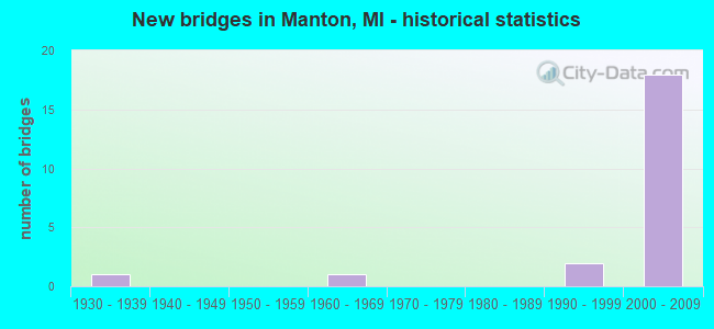
- New bridges - historical statistics
- 11930-1939
- 11960-1969
- 21990-1999
- 182000-2009


- Bridge Condition - Deck
- 8.3%Very good
- 75.0%Good
- 16.7%Satisfactory

- Bridge Condition - Superstructure
- 23.1%Very good
- 53.8%Good
- 23.1%Satisfactory

- Bridge Condition - Substructure
- 7.7%Very good
- 46.2%Good
- 38.5%Satisfactory
- 7.7%Fair

- Bridge Condition - Channel
- 28.6%Very good
- 28.6%Good
- 42.9%Satisfactory
Find on map >> Show street view
Structure Number: 2043, Location: 3.3 MI N OF M-72 (Lat: 44.704431, Lng: -84.699206), Route carried "on" structure: Interstate 75, Year Built: 1961, Status: Open, Structure Length: 3.01m (9.88ft), Average Daily Traffic: 7,158 (year 2007), Truck Traffic: 11%, Average Future Daily Traffic: 8,178 (year 2018), Design Load: HS 20, Features Intersected: LEWISTON GRADE ROAD
Minimum Vertical Clearance: 30.48m (100.00ft), Kilometerpoint: 22.876, Lanes on structure: 2, Lanes under structure: 2, Base Highway Network: Yes (Inventory Route: 53, Subroute: 2), Owner: State Highway Agency, Approaching Roadway Width: 13.7m (44.9ft), Material/Design: Prestressed concrete, Design/Construction: Stringer/Multi-beam, Number Of Spans In Main Unit: 3, Length of Maximum Span: 10.0m (32.8ft), Curb-To-Curb Width: 12.8m (42.0ft), Out-to-Out Width: 14.3m (46.9ft)
Condition: Deck: Satisfactory, Superstructure: Satisfactory, Substructure: Fair, Operating Rating: 69.0 metric tons, Method Used To Determine Operating Rating: Load Factor (LF) rating reported by rating factor (RF) method using MS18 loading, Inventory Rating: 41.5 metric tons, Method Used To Determine Inventory Rating: Load Factor (LF) rating reported by rating factor (RF) method using MS18 loading, Structural Evaluation: Somewhat better than minimum adequacy, Deck Geometry: Equal to present desirable criteria, Underclear: Meets minimum limits, Approach Roadway Alignment: Equal to present desirable criteria, Designated Inspection Frequency: Every 24 months, Inspection Date: September 2021, Deck Structure Type: Concrete Cast-file-Place, Wearing Surface/Protective System: Wearing Surface: Epoxy Overlay
Find on map >> Show street view
Structure Number: 2094, Location: 1.3 MI E NAHMA JUNCTION (Lat: 45.893292, Lng: -86.683717), Route carried "on" structure: US 2, Year Built: 1936, Year Reconstructed: 1990, Status: Open, Structure Length: 1.06m (3.48ft), Average Daily Traffic: 3,462 (year 2007), Truck Traffic: 14%, Average Future Daily Traffic: 6,463 (year 2018), Design Load: H 15, Features Intersected: BULL RUN CREEK
Minimum Vertical Clearance: 30.48m (100.00ft), Kilometerpoint: 76.509, Lanes on structure: 2, Base Highway Network: Yes (Inventory Route: 134, Subroute: 6), Owner: State Highway Agency, Approaching Roadway Width: 12.8m (42.0ft), Material/Design: Prestressed concrete, Design/Construction: Stringer/Multi-beam, Number Of Spans In Main Unit: 1, Length of Maximum Span: 10.6m (34.8ft), Curb-To-Curb Width: 13.4m (44.0ft), Out-to-Out Width: 14.4m (47.2ft)
Condition: Deck: Good, Superstructure: Very good, Substructure: Good, Channel: Good, Operating Rating: 69.3 metric tons, Method Used To Determine Operating Rating: Load Factor (LF) rating reported by rating factor (RF) method using MS18 loading, Inventory Rating: 41.5 metric tons, Method Used To Determine Inventory Rating: Load Factor (LF) rating reported by rating factor (RF) method using MS18 loading, Structural Evaluation: Better than present minimum criteria, Deck Geometry: Better than present minimum criteria, Waterway Adequacy: Better than present minimum criteria, Approach Roadway Alignment: Equal to present desirable criteria, Designated Inspection Frequency: Every 24 months, Inspection Date: September 2021, Deck Structure Type: Concrete Cast-file-Place, Wearing Surface/Protective System: Wearing Surface: Latex Concrete
Find on map >> Show street view
Structure Number: 12572, Location: IN MANTON (Lat: 44.403797, Lng: -85.393153), Route carried "on" structure: State highway 42, Year Built: 2004, Status: Open, Structure Length: 1.18m (3.87ft), Average Daily Traffic: 2,850 (year 2007), Truck Traffic: 6%, Average Future Daily Traffic: 4,434 (year 2018), Design Load: HS 25 or greater, Features Intersected: CEDAR CREEK
Minimum Vertical Clearance: 30.48m (100.00ft), Kilometerpoint: 5.282, Lanes on structure: 2, Base Highway Network: Yes (Inventory Route: 112, Subroute: 9), Owner: State Highway Agency, Approaching Roadway Width: 17.1m (56.1ft), Material/Design: Concrete, Design/Construction: Culvert, Number Of Spans In Main Unit: 1, Length of Maximum Span: 11.0m (36.1ft), Out-to-Out Width: 10.4m (34.1ft)
Condition: Channel: Very good, Culverts: Very good, Operating Rating: 62.2 metric tons, Method Used To Determine Operating Rating: Load Factor (LF) rating reported by rating factor (RF) method using MS18 loading, Inventory Rating: 37.3 metric tons, Method Used To Determine Inventory Rating: Load Factor (LF) rating reported by rating factor (RF) method using MS18 loading, Structural Evaluation: Equal to present desirable criteria, Waterway Adequacy: Equal to present desirable criteria, Approach Roadway Alignment: Better than present minimum criteria, Designated Inspection Frequency: Every 24 months, Inspection Date: July 2020, Deck Structure Type: Concrete Cast-file-Place, Wearing Surface/Protective System: Wearing Surface: Bituminous
Find on map >> Show street view
Structure Number: 12579, Location: SECTION 20/29 T24N R9W (Lat: 44.454111, Lng: -85.426186), Route carried "on" structure: County highway 8380, Year Built: 1994, Status: Open, Structure Length: 0.76m (2.49ft), Average Daily Traffic: 440 (year 2005), Truck Traffic: 5%, Average Future Daily Traffic: 800 (year 2025), Design Load: HS 20, Features Intersected: MANTON CREEK, Facility Carried by Structure: NO 10 ROAD
Minimum Vertical Clearance: 30.48m (100.00ft), Kilometerpoint: 7.324, Lanes on structure: 2, Owner: County Highway Agency, Approaching Roadway Width: 10.1m (33.1ft), Skew: 2 degrees, Material/Design: Wood or Timber, Design/Construction: Slab, Number Of Spans In Main Unit: 1, Length of Maximum Span: 7.6m (24.9ft), Curb-To-Curb Width: 9.1m (29.9ft), Out-to-Out Width: 9.7m (31.8ft)
Condition: Deck: Good, Superstructure: Good, Substructure: Good, Channel: Satisfactory, Operating Rating: 63.8 metric tons, Method Used To Determine Operating Rating: Allowable Stress (AS) rating reported by rating factor (RF) method using MS18 loading, Inventory Rating: 46.0 metric tons, Method Used To Determine Inventory Rating: Allowable Stress (AS) rating reported by rating factor (RF) method using MS18 loading, Structural Evaluation: Better than present minimum criteria, Deck Geometry: Equal to present minimum criteria, Waterway Adequacy: Meets minimum limits, Approach Roadway Alignment: Equal to present minimum criteria, Designated Inspection Frequency: Every 24 months, Inspection Date: July 2020, Deck Structure Type: Aluminum, Wearing Surface/Protective System: Wearing Surface: Bituminous, Membrane: Preformed Fabric
Find on map >> Show street view
Structure Number: 1258, Location: SECTION 33 T24N R9W (Lat: 44.425150, Lng: -85.408281), Route carried "on" structure: County highway , Year Built: 2001, Status: Open, Structure Length: 0.73m (2.40ft), Average Daily Traffic: 980 (year 2005), Truck Traffic: 2%, Average Future Daily Traffic: 1,770 (year 2025), Design Load: HS 25 or greater, Features Intersected: MANTON CREEK, Facility Carried by Structure: NO 14 ROAD
Minimum Vertical Clearance: 30.48m (100.00ft), Kilometerpoint: 23.792, Lanes on structure: 2, Owner: County Highway Agency, Approaching Roadway Width: 10.1m (33.1ft), Material/Design: Concrete, Design/Construction: Culvert, Number Of Spans In Main Unit: 1, Length of Maximum Span: 7.3m (24.0ft), Curb-To-Curb Width: 9.8m (32.2ft), Out-to-Out Width: 10.6m (34.8ft)
Condition: Channel: Satisfactory, Culverts: Very good, Operating Rating: 53.1 metric tons, Method Used To Determine Operating Rating: Load Factor (LF) rating reported by rating factor (RF) method using MS18 loading, Inventory Rating: 32.1 metric tons, Method Used To Determine Inventory Rating: Load Factor (LF) rating reported by rating factor (RF) method using MS18 loading, Structural Evaluation: Better than present minimum criteria, Deck Geometry: Equal to present minimum criteria, Waterway Adequacy: Somewhat better than minimum adequacy, Approach Roadway Alignment: Equal to present desirable criteria, Designated Inspection Frequency: Every 24 months, Inspection Date: July 2020, Wearing Surface/Protective System: Wearing Surface: Bituminous
Find on map >> Show street view
Structure Number: 12584, Location: SECTION 29/32 T24N R9W (Lat: 44.439742, Lng: -85.425725), Route carried "on" structure: County highway , Year Built: 2002, Status: Open, Structure Length: 0.76m (2.49ft), Average Daily Traffic: 120 (year 2005), Average Future Daily Traffic: 210 (year 2025), Design Load: HS 20, Features Intersected: MANTON CREEK, Facility Carried by Structure: NO 12 ROAD
Minimum Vertical Clearance: 30.48m (100.00ft), Kilometerpoint: 7.403, Lanes on structure: 2, Owner: County Highway Agency, Approaching Roadway Width: 7.0m (23.0ft), Material/Design: Wood or Timber, Design/Construction: Slab, Number Of Spans In Main Unit: 1, Length of Maximum Span: 7.0m (23.0ft), Curb-To-Curb Width: 7.3m (24.0ft), Out-to-Out Width: 7.9m (25.9ft)
Condition: Deck: Very good, Superstructure: Very good, Substructure: Good, Channel: Good, Operating Rating: 27.5 metric tons, Method Used To Determine Operating Rating: Load and Resistance Factor Rating (LRFR) rating reported by rating factor(RF) method using HL-93 loadings, Inventory Rating: 21.4 metric tons, Method Used To Determine Inventory Rating: Load and Resistance Factor Rating (LRFR) rating reported by rating factor(RF) method using HL-93 loadings, Structural Evaluation: Equal to present minimum criteria, Deck Geometry: Somewhat better than minimum adequacy, Waterway Adequacy: Equal to present minimum criteria, Approach Roadway Alignment: Better than present minimum criteria, Designated Inspection Frequency: Every 24 months, Inspection Date: July 2020, Deck Structure Type: Wood or Timber
Find on map >> Show street view
Structure Number: 12585, Location: SECTION 32/33 T24N R9W (Lat: 44.434117, Lng: -85.418172), Route carried "on" structure: County highway , Year Built: 1998, Status: Open, Structure Length: 0.67m (2.20ft), Average Daily Traffic: 256 (year 2005), Truck Traffic: 4%, Average Future Daily Traffic: 460 (year 2025), Features Intersected: MANTON CREEK, Facility Carried by Structure: NO 41 ROAD
Minimum Vertical Clearance: 30.48m (100.00ft), Kilometerpoint: 7.535, Lanes on structure: 2, Owner: County Highway Agency, Approaching Roadway Width: 7.0m (23.0ft), Material/Design: Concrete, Design/Construction: Arch - Deck, Number Of Spans In Main Unit: 1, Length of Maximum Span: 6.4m (21.0ft), Curb-To-Curb Width: 9.1m (29.9ft), Out-to-Out Width: 9.8m (32.2ft)
Condition: Superstructure: Good, Substructure: Satisfactory, Channel: Satisfactory, Operating Rating: 51.5 metric tons, Method Used To Determine Operating Rating: Load Factor (LF) rating reported by rating factor (RF) method using MS18 loading, Inventory Rating: 30.8 metric tons, Method Used To Determine Inventory Rating: Load Factor (LF) rating reported by rating factor (RF) method using MS18 loading, Structural Evaluation: Equal to present minimum criteria, Deck Geometry: Equal to present minimum criteria, Waterway Adequacy: Equal to present minimum criteria, Approach Roadway Alignment: Equal to present minimum criteria, Designated Inspection Frequency: Every 24 months, Inspection Date: July 2020, Deck Structure Type: Concrete Cast-file-Place, Wearing Surface/Protective System: Wearing Surface: Bituminous
Find on map >> Show street view
Structure Number: 13029, Location: 3 MI N OF CADILLAC (Lat: 44.372431, Lng: -85.397664), Route carried "on" structure: US 131, Year Built: 2002, Status: Open, Structure Length: 14.49m (47.54ft), Average Daily Traffic: 3,350 (year 2007), Truck Traffic: 9%, Average Future Daily Traffic: 3,853 (year 2027), Design Load: HS 25 or greater, Features Intersected: US-131
Minimum Vertical Clearance: 30.48m (100.00ft), Kilometerpoint: 17.773, Lanes on structure: 2, Lanes under structure: 4, Base Highway Network: Yes (Inventory Route: 383, Subroute: 70), Owner: State Highway Agency, Approaching Roadway Width: 13.2m (43.3ft), Skew: 3 degrees, Material/Design: Prestressed concrete, Design/Construction: Stringer/Multi-beam, Number Of Spans In Main Unit: 5, Length of Maximum Span: 44.2m (145.0ft), Curb-To-Curb Width: 13.1m (43.0ft), Out-to-Out Width: 14.4m (47.2ft)
Condition: Deck: Satisfactory, Superstructure: Good, Substructure: Satisfactory, Operating Rating: 75.2 metric tons, Method Used To Determine Operating Rating: Load Factor (LF) rating reported by rating factor (RF) method using MS18 loading, Inventory Rating: 46.7 metric tons, Method Used To Determine Inventory Rating: Load Factor (LF) rating reported by rating factor (RF) method using MS18 loading, Structural Evaluation: Equal to present minimum criteria, Deck Geometry: Equal to present minimum criteria, Underclear: Somewhat better than minimum adequacy, Approach Roadway Alignment: Superior to present desirable criteria, Designated Inspection Frequency: Every 24 months, Inspection Date: July 2021, Deck Structure Type: Concrete Cast-file-Place, Wearing Surface/Protective System: Wearing Surface: Epoxy Overlay, Deck Protection: Epoxy Coated Reinforcing
Find on map >> Show street view
Structure Number: 13031, Location: 1 MI E OF MANTON (Lat: 44.403819, Lng: -85.381083), Route carried "on" structure: US 131, Year Built: 2002, Status: Open, Structure Length: 6.07m (19.91ft), Average Daily Traffic: 3,575 (year 2007), Truck Traffic: 9%, Average Future Daily Traffic: 8,750 (year 2020), Design Load: HS 25 or greater, Features Intersected: M-42 (16 1/2 RD)
Minimum Vertical Clearance: 30.48m (100.00ft), Kilometerpoint: 30.017, Lanes on structure: 2, Lanes under structure: 3, Base Highway Network: Yes (Inventory Route: 383, Subroute: 27), Owner: State Highway Agency, Approaching Roadway Width: 12.9m (42.3ft), Material/Design: Prestressed concrete, Design/Construction: Stringer/Multi-beam, Number Of Spans In Main Unit: 3, Length of Maximum Span: 36.4m (119.4ft), Curb-To-Curb Width: 21.2m (69.6ft), Out-to-Out Width: 22.2m (72.8ft)
Condition: Deck: Good, Superstructure: Good, Substructure: Satisfactory, Operating Rating: 72.6 metric tons, Method Used To Determine Operating Rating: Load Factor (LF) rating reported by rating factor (RF) method using MS18 loading, Inventory Rating: 43.4 metric tons, Method Used To Determine Inventory Rating: Load Factor (LF) rating reported by rating factor (RF) method using MS18 loading, Structural Evaluation: Equal to present minimum criteria, Deck Geometry: Superior to present desirable criteria, Underclear: Meets minimum limits, Approach Roadway Alignment: Superior to present desirable criteria, Designated Inspection Frequency: Every 24 months, Inspection Date: July 2021, Deck Structure Type: Concrete Cast-file-Place, Wearing Surface/Protective System: Wearing Surface: Epoxy Overlay, Deck Protection: Epoxy Coated Reinforcing
Find on map >> Show street view
Structure Number: 13032, Location: 1 MI E OF MANTON (Lat: 44.403825, Lng: -85.381614), Route carried "on" structure: US 131, Year Built: 2002, Status: Open, Structure Length: 5.94m (19.49ft), Average Daily Traffic: 3,575 (year 2007), Truck Traffic: 9%, Average Future Daily Traffic: 8,750 (year 2020), Design Load: HS 25 or greater, Features Intersected: M-42 (16 1/2 RD)
Minimum Vertical Clearance: 30.48m (100.00ft), Kilometerpoint: 30.049, Lanes on structure: 3, Lanes under structure: 2, Base Highway Network: Yes (Inventory Route: 383, Subroute: 28), Owner: State Highway Agency, Approaching Roadway Width: 17.4m (57.1ft), Material/Design: Prestressed concrete, Design/Construction: Stringer/Multi-beam, Number Of Spans In Main Unit: 3, Length of Maximum Span: 35.0m (114.8ft), Curb-To-Curb Width: 18.9m (62.0ft), Out-to-Out Width: 19.9m (65.3ft)
Condition: Deck: Good, Superstructure: Satisfactory, Substructure: Good, Operating Rating: 71.9 metric tons, Method Used To Determine Operating Rating: Load Factor (LF) rating reported by rating factor (RF) method using MS18 loading, Inventory Rating: 43.1 metric tons, Method Used To Determine Inventory Rating: Load Factor (LF) rating reported by rating factor (RF) method using MS18 loading, Structural Evaluation: Equal to present minimum criteria, Deck Geometry: Superior to present desirable criteria, Underclear: Meets minimum limits, Approach Roadway Alignment: Superior to present desirable criteria, Designated Inspection Frequency: Every 24 months, Inspection Date: July 2021, Deck Structure Type: Concrete Cast-file-Place, Wearing Surface/Protective System: Wearing Surface: Epoxy Overlay, Deck Protection: Epoxy Coated Reinforcing
Find on map >> Show street view
Structure Number: 13033, Location: 1 MI E OF MANTON (Lat: 44.410958, Lng: -85.380411), Route carried "on" structure: County highway , Year Built: 2002, Status: Open, Structure Length: 8.94m (29.33ft), Average Daily Traffic: 150 (year 2000), Truck Traffic: 9%, Average Future Daily Traffic: 173 (year 2020), Design Load: HS 25 or greater, Features Intersected: US-131, Facility Carried by Structure: NO. 16 RD
Minimum Vertical Clearance: 30.48m (100.00ft), Kilometerpoint: 27.003, Lanes on structure: 2, Lanes under structure: 4, Owner: State Highway Agency, Approaching Roadway Width: 12.6m (41.3ft), Material/Design: Prestressed concrete, Design/Construction: Stringer/Multi-beam, Number Of Spans In Main Unit: 2, Length of Maximum Span: 44.7m (146.7ft), Curb-To-Curb Width: 13.4m (44.0ft), Out-to-Out Width: 14.4m (47.2ft)
Condition: Deck: Good, Superstructure: Good, Substructure: Satisfactory, Operating Rating: 87.2 metric tons, Method Used To Determine Operating Rating: Load Factor (LF) rating reported by rating factor (RF) method using MS18 loading, Inventory Rating: 41.8 metric tons, Method Used To Determine Inventory Rating: Load Factor (LF) rating reported by rating factor (RF) method using MS18 loading, Structural Evaluation: Equal to present minimum criteria, Deck Geometry: Superior to present desirable criteria, Underclear: Superior to present desirable criteria, Approach Roadway Alignment: Superior to present desirable criteria, Designated Inspection Frequency: Every 24 months, Inspection Date: July 2021, Deck Structure Type: Concrete Cast-file-Place, Wearing Surface/Protective System: Wearing Surface: Epoxy Overlay, Deck Protection: Epoxy Coated Reinforcing
Find on map >> Show street view
Structure Number: 13034, Location: 1 MI NE OF MANTON (Lat: 44.428853, Lng: -85.388831), Route carried "on" structure: US 131, Year Built: 2002, Status: Open, Structure Length: 3.39m (11.12ft), Average Daily Traffic: 3,535 (year 2007), Average Future Daily Traffic: 4,065 (year 2027), Design Load: HS 25 or greater, Features Intersected: NO 12 3/4 RD
Minimum Vertical Clearance: 30.48m (100.00ft), Kilometerpoint: 32.965, Lanes on structure: 2, Lanes under structure: 2, Base Highway Network: Yes (Inventory Route: 383, Subroute: 28), Owner: State Highway Agency, Approaching Roadway Width: 13.2m (43.3ft), Skew: 2 degrees, Material/Design: Prestressed concrete, Design/Construction: Stringer/Multi-beam, Number Of Spans In Main Unit: 1, Length of Maximum Span: 33.9m (111.2ft), Curb-To-Curb Width: 13.2m (43.3ft), Out-to-Out Width: 14.2m (46.6ft)
Condition: Deck: Good, Superstructure: Good, Substructure: Very good, Operating Rating: 60.6 metric tons, Method Used To Determine Operating Rating: Load and Resistance Factor Rating (LRFR) rating reported by rating factor(RF) method using HL-93 loadings, Inventory Rating: 41.1 metric tons, Method Used To Determine Inventory Rating: Load and Resistance Factor Rating (LRFR) rating reported by rating factor(RF) method using HL-93 loadings, Structural Evaluation: Better than present minimum criteria, Deck Geometry: Superior to present desirable criteria, Underclear: Meets minimum limits, Approach Roadway Alignment: Superior to present desirable criteria, Designated Inspection Frequency: Every 24 months, Inspection Date: July 2021, Deck Structure Type: Concrete Cast-file-Place, Wearing Surface/Protective System: Wearing Surface: Epoxy Overlay, Deck Protection: Epoxy Coated Reinforcing
Find on map >> Show street view
Structure Number: 13035, Location: 1 MI NE OF MANTON (Lat: 44.428853, Lng: -85.388233), Route carried "on" structure: US 131, Year Built: 2002, Status: Open, Structure Length: 3.39m (11.12ft), Average Daily Traffic: 3,535 (year 2007), Average Future Daily Traffic: 4,065 (year 2027), Design Load: HS 25 or greater, Features Intersected: NO 12 3/4 RD
Minimum Vertical Clearance: 30.48m (100.00ft), Kilometerpoint: 32.933, Lanes on structure: 2, Lanes under structure: 2, Base Highway Network: Yes (Inventory Route: 383, Subroute: 27), Owner: State Highway Agency, Approaching Roadway Width: 13.2m (43.3ft), Skew: 2 degrees, Material/Design: Prestressed concrete, Design/Construction: Stringer/Multi-beam, Number Of Spans In Main Unit: 1, Length of Maximum Span: 33.9m (111.2ft), Curb-To-Curb Width: 13.2m (43.3ft), Out-to-Out Width: 14.2m (46.6ft)
Condition: Deck: Good, Superstructure: Good, Substructure: Good, Operating Rating: 80.7 metric tons, Method Used To Determine Operating Rating: Load Factor (LF) rating reported by rating factor (RF) method using MS18 loading, Inventory Rating: 31.8 metric tons, Method Used To Determine Inventory Rating: Load Factor (LF) rating reported by rating factor (RF) method using MS18 loading, Structural Evaluation: Better than present minimum criteria, Deck Geometry: Superior to present desirable criteria, Underclear: Meets minimum limits, Approach Roadway Alignment: Superior to present desirable criteria, Designated Inspection Frequency: Every 24 months, Inspection Date: July 2021, Deck Structure Type: Concrete Cast-file-Place, Wearing Surface/Protective System: Wearing Surface: Epoxy Overlay, Deck Protection: Epoxy Coated Reinforcing
Find on map >> Show street view
Structure Number: 13036, Location: 2 MI N OF MANTON (Lat: 44.454253, Lng: -85.395067), Route carried "on" structure: County highway , Year Built: 2002, Status: Open, Structure Length: 8.88m (29.13ft), Average Daily Traffic: 95 (year 2001), Average Future Daily Traffic: 109 (year 2021), Design Load: HS 25 or greater, Features Intersected: US-131, Facility Carried by Structure: NO. 10 RD
Minimum Vertical Clearance: 30.48m (100.00ft), Kilometerpoint: 9.801, Lanes on structure: 2, Lanes under structure: 4, Owner: State Highway Agency, Approaching Roadway Width: 10.8m (35.4ft), Material/Design: Prestressed concrete, Design/Construction: Stringer/Multi-beam, Number Of Spans In Main Unit: 2, Length of Maximum Span: 44.4m (145.7ft), Curb or Sidewalk Widths: Left: 0.0m, Right: 3.2m (10.5ft), Curb-To-Curb Width: 9.6m (31.5ft), Out-to-Out Width: 14.2m (46.6ft)
Condition: Deck: Good, Superstructure: Very good, Substructure: Good, Operating Rating: 59.6 metric tons, Method Used To Determine Operating Rating: Load Factor (LF), Inventory Rating: 44.8 metric tons, Method Used To Determine Inventory Rating: Load Factor (LF), Structural Evaluation: Better than present minimum criteria, Deck Geometry: Better than present minimum criteria, Underclear: Better than present minimum criteria, Approach Roadway Alignment: Superior to present desirable criteria, Designated Inspection Frequency: Every 24 months, Inspection Date: July 2021, Deck Structure Type: Concrete Cast-file-Place, Wearing Surface/Protective System: Wearing Surface: Epoxy Overlay, Deck Protection: Epoxy Coated Reinforcing
Find on map >> Show street view
Structure Number: 13444, Location: 5.7 MI N OF MANTON (Lat: 44.484450, Lng: -85.406358), Route carried "on" structure: US 131, Year Built: 2009, Status: Open, Structure Length: 10.21m (33.50ft), Average Daily Traffic: 8,450 (year 2003), Truck Traffic: 8%, Average Future Daily Traffic: 10,478 (year 2018), Design Load: Greater than HL93, Features Intersected: MANISTEE RIVER
Minimum Vertical Clearance: 30.48m (100.00ft), Kilometerpoint: 39.517, Lanes on structure: 2, Base Highway Network: Yes (Inventory Route: 383, Subroute: 27), Owner: State Highway Agency, Approaching Roadway Width: 13.4m (44.0ft), Material/Design: Prestressed concrete, Design/Construction: Stringer/Multi-beam, Number Of Spans In Main Unit: 3, Length of Maximum Span: 33.6m (110.2ft), Curb-To-Curb Width: 13.4m (44.0ft), Out-to-Out Width: 14.4m (47.2ft)
Condition: Deck: Good, Superstructure: Satisfactory, Substructure: Satisfactory, Channel: Very good, Operating Rating: 75.6 metric tons, Method Used To Determine Operating Rating: Load Factor (LF), Inventory Rating: 42.4 metric tons, Method Used To Determine Inventory Rating: Load Factor (LF), Structural Evaluation: Equal to present minimum criteria, Deck Geometry: Equal to present minimum criteria, Waterway Adequacy: Superior to present desirable criteria, Approach Roadway Alignment: Equal to present desirable criteria, Designated Inspection Frequency: Every 24 months, Inspection Date: June 2020, Deck Structure Type: Concrete Cast-file-Place, Wearing Surface/Protective System: Wearing Surface: Epoxy Overlay, Deck Protection: Epoxy Coated Reinforcing
Find on map >> Show street view
Structure Number: 13029, Location: 3 MI N OF CADILLAC (Lat: 44.372431, Lng: -85.397664), Route carried "under" structure: US 131, Year Built: 2002, Structure Length: 0. m, Average Daily Traffic: 7,150 (year 2007), Truck Traffic: 9%, Features Intersected: US-131
Minimum Vertical Clearance: 5.97m (19.59ft), Kilometerpoint: 26.116, Lanes on structure: 2, Lanes under structure: 4, Material/Design: Prestressed concrete, Design/Construction: Stringer/Multi-beam, Length of Maximum Span: 44.2m (145.0ft)
Find on map >> Show street view
Structure Number: 13031, Location: 1 MI E OF MANTON (Lat: 44.403819, Lng: -85.381083), Route carried "under" structure: State highway 42, Year Built: 2002, Structure Length: 0. m, Average Daily Traffic: 3,223 (year 2007), Features Intersected: M-42 (16 1/2 RD), Facility Carried by Structure: US-131 NB
Minimum Vertical Clearance: 6.12m (20.08ft), Kilometerpoint: 6.244, Lanes on structure: 2, Lanes under structure: 3, Material/Design: Prestressed concrete, Design/Construction: Stringer/Multi-beam, Length of Maximum Span: 36.4m (119.4ft)
Find on map >> Show street view
Structure Number: 13032, Location: 1 MI E OF MANTON (Lat: 44.403825, Lng: -85.381614), Route carried "under" structure: State highway 42, Year Built: 2002, Structure Length: 0. m, Average Daily Traffic: 2,850 (year 2007), Features Intersected: M-42 (16 1/2 RD), Facility Carried by Structure: US-131 SB
Minimum Vertical Clearance: 6.10m (20.01ft), Kilometerpoint: 6.203, Lanes on structure: 3, Lanes under structure: 2, Material/Design: Prestressed concrete, Design/Construction: Stringer/Multi-beam, Length of Maximum Span: 35.0m (114.8ft)
Find on map >> Show street view
Structure Number: 13033, Location: 1 MI E OF MANTON (Lat: 44.410958, Lng: -85.380411), Route carried "under" structure: US 131, Year Built: 2002, Structure Length: 0. m, Average Daily Traffic: 7,070 (year 2007), Features Intersected: US-131, Facility Carried by Structure: NO. 16 RD
Minimum Vertical Clearance: 5.49m (18.01ft), Kilometerpoint: 30.812, Lanes on structure: 2, Lanes under structure: 4, Material/Design: Prestressed concrete, Design/Construction: Stringer/Multi-beam, Length of Maximum Span: 44.7m (146.7ft)
Find on map >> Show street view
Structure Number: 13034, Location: 1 MI NE OF MANTON (Lat: 44.428853, Lng: -85.388831), Route carried "under" structure: County highway , Year Built: 2002, Structure Length: 0. m, Average Daily Traffic: 83 (year 2001), Features Intersected: NO 12 3/4 RD, Facility Carried by Structure: US-131 SB
Minimum Vertical Clearance: 5.23m (17.16ft), Kilometerpoint: 0.763, Lanes on structure: 2, Lanes under structure: 2, Material/Design: Prestressed concrete, Design/Construction: Stringer/Multi-beam, Length of Maximum Span: 33.9m (111.2ft)
Find on map >> Show street view
Structure Number: 13035, Location: 1 MI NE OF MANTON (Lat: 44.428853, Lng: -85.388233), Route carried "under" structure: County highway , Year Built: 2002, Structure Length: 0. m, Average Daily Traffic: 83 (year 2001), Features Intersected: NO 12 3/4 RD, Facility Carried by Structure: US-131 NB
Minimum Vertical Clearance: 5.23m (17.16ft), Kilometerpoint: 0.811, Lanes on structure: 2, Lanes under structure: 2, Material/Design: Prestressed concrete, Design/Construction: Stringer/Multi-beam, Length of Maximum Span: 33.9m (111.2ft)
Find on map >> Show street view
Structure Number: 13036, Location: 2 MI N OF MANTON (Lat: 44.454253, Lng: -85.395067), Route carried "under" structure: US 131, Year Built: 2002, Structure Length: 0. m, Average Daily Traffic: 7,070 (year 2007), Features Intersected: US-131, Facility Carried by Structure: NO. 10 RD
Minimum Vertical Clearance: 5.94m (19.49ft), Kilometerpoint: 35.861, Lanes on structure: 2, Lanes under structure: 4, Material/Design: Prestressed concrete, Design/Construction: Stringer/Multi-beam, Length of Maximum Span: 44.4m (145.7ft)