Bridge Statistics for Manchester, Pennsylvania (PA)
Condition, Traffic, Stress, Structural Evaluation, Project Costs
- National Bridge Inventory (NBI) Statistics
- 15Number of bridges
- 154ft / 46.8mTotal length
- $2,648,000Total costs
- 226,635Total average daily traffic
- 40,974Total average daily truck traffic
- National Bridge Inventory (NBI) Registered Bridges for Manchester
- No street view available for this location
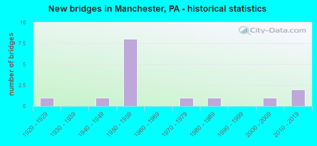
- New bridges - historical statistics
- 11920-1929
- 11940-1949
- 81950-1959
- 11970-1979
- 11980-1989
- 12000-2009
- 22010-2019


- Bridge Condition - Deck
- 22.2%Very good
- 33.3%Good
- 11.1%Satisfactory
- 22.2%Fair
- 11.1%Poor

- Bridge Condition - Superstructure
- 33.3%Very good
- 33.3%Good
- 11.1%Satisfactory
- 11.1%Fair
- 11.1%Poor

- Bridge Condition - Substructure
- 11.1%Very good
- 44.4%Good
- 11.1%Satisfactory
- 22.2%Fair
- 11.1%Poor

- Bridge Condition - Channel
- 10.0%Very good
- 10.0%Good
- 50.0%Satisfactory
- 20.0%Fair
- 10.0%Poor

- Bridge Condition - Culverts
- 66.7%Satisfactory
- 33.3%Fair
Find on map >> Show street view
Structure Number: 37453, Location: LR333&LR66002 INTER (Lat: 40.052822, Lng: -76.752403), Route carried "on" structure: Interstate 83, Year Built: 1957, Year Reconstructed: 1998, Status: Open, Structure Length: 3.60m (11.81ft), Average Daily Traffic: 45,604 (year 2022), Truck Traffic: 19%, Average Future Daily Traffic: 58,901 (year 2032), Design Load: HS 25 or greater, Features Intersected: PA 921; Canal rd.
Minimum Vertical Clearance: 30+ m (98+ ft), Kilometerpoint: 41.759, Lanes on structure: 4, Lanes under structure: 2, Base Highway Network: Yes, Owner: State Highway Agency, Approaching Roadway Width: 25.9m (85.0ft), Skew: 30 degrees, Material/Design: Steel continuous, Design/Construction: Stringer/Multi-beam, Number Of Spans In Main Unit: 3, Length of Maximum Span: 14.0m (45.9ft), Curb or Sidewalk Widths: Left: 0.3m (1.0ft), Right: 0.3m (1.0ft), Curb-To-Curb Width: 11.6m (38.1ft), Out-to-Out Width: 27.6m (90.6ft)
Condition: Deck: Satisfactory, Superstructure: Good, Substructure: Fair, Inventory Rating: 63.5 metric tons, Method Used To Determine Inventory Rating: Load Factor (LF), Structural Evaluation: Somewhat better than minimum adequacy, Deck Geometry: High priority of replacement, Underclear: Equal to present minimum criteria, Approach Roadway Alignment: Equal to present desirable criteria, Length Of Structure Improvement: 3.50m (11.48ft), Designated Inspection Frequency: Every 24 months, Inspection Date: August 2021, Deck Structure Type: Concrete Cast-file-Place, Wearing Surface/Protective System: Wearing Surface: Monolithic Concrete, Deck Protection: Epoxy Coated Reinforcing
Find on map >> Show street view
Structure Number: 37454, Location: 1.5 MI S EXIT-28; I-83 (Lat: 40.061308, Lng: -76.755183), Route carried "on" structure: Interstate 83, Year Built: 1957, Status: Open, Structure Length: 3.66m (12.01ft), Average Daily Traffic: 45,604 (year 2022), Truck Traffic: 19%, Average Future Daily Traffic: 58,901 (year 2032), Design Load: HS 20, Features Intersected: LITTLE CONEWAGO CREEK
Minimum Vertical Clearance: 30+ m (98+ ft), Kilometerpoint: 42.564, Lanes on structure: 4, Base Highway Network: Yes, Owner: State Highway Agency, Approaching Roadway Width: 25.9m (85.0ft), Skew: 30 degrees, Material/Design: Concrete, Design/Construction: Culvert, Number Of Spans In Main Unit: 1, Length of Maximum Span: 36.6m (120.1ft)
Condition: Channel: Satisfactory, Culverts: Satisfactory, Operating Rating: 59.0 metric tons, Method Used To Determine Operating Rating: Field evaluation and documented engineering judgment, Inventory Rating: 35.4 metric tons, Method Used To Determine Inventory Rating: Field evaluation and documented engineering judgment, Structural Evaluation: Equal to present minimum criteria, Waterway Adequacy: Superior to present desirable criteria, Approach Roadway Alignment: Equal to present desirable criteria, Length Of Structure Improvement: 4.60m (15.09ft), Designated Inspection Frequency: Every 24 months, Inspection Date: August 2021
Find on map >> Show street view
Structure Number: 37455, Location: 0.5 MI.S. OF EXIT-28 (Lat: 40.076536, Lng: -76.761606), Route carried "on" structure: Interstate 83, Year Built: 1954, Status: Open, Structure Length: 0.70m (2.30ft), Average Daily Traffic: 45,604 (year 2022), Truck Traffic: 19%, Average Future Daily Traffic: 58,901 (year 2032), Design Load: HS 20, Features Intersected: TRIB TO LITTLE CONEWAGO
Minimum Vertical Clearance: 30+ m (98+ ft), Kilometerpoint: 44.173, Lanes on structure: 4, Base Highway Network: Yes, Owner: State Highway Agency, Approaching Roadway Width: 25.9m (85.0ft), Skew: 33 degrees, Material/Design: Concrete, Design/Construction: Culvert, Number Of Spans In Main Unit: 1, Length of Maximum Span: 7.0m (23.0ft)
Condition: Channel: Satisfactory, Culverts: Satisfactory, Operating Rating: 63.5 metric tons, Method Used To Determine Operating Rating: Allowable Stress (AS), Inventory Rating: 42.6 metric tons, Method Used To Determine Inventory Rating: Allowable Stress (AS), Structural Evaluation: Equal to present minimum criteria, Waterway Adequacy: Superior to present desirable criteria, Approach Roadway Alignment: Equal to present desirable criteria, Length Of Structure Improvement: 1.30m (4.27ft), Designated Inspection Frequency: Every 24 months, Inspection Date: September 2021
Find on map >> Show street view
Structure Number: 37505, Location: 1.25 MI.N. OF MANCHESTER (Lat: 40.081222, Lng: -76.718044), Route carried "on" structure: State highway 181, Year Built: 1984, Status: Open, Structure Length: 12.37m (40.58ft), Average Daily Traffic: 2,355 (year 2022), Truck Traffic: 13%, Average Future Daily Traffic: 3,259 (year 2032), Design Load: HS 25 or greater, Features Intersected: CONEWAGO CREEK
Minimum Vertical Clearance: 30+ m (98+ ft), Kilometerpoint: 11.024, Lanes on structure: 2, Owner: State Highway Agency, Approaching Roadway Width: 11.6m (38.1ft), Material/Design: Prestressed concrete, Design/Construction: Stringer/Multi-beam, Number Of Spans In Main Unit: 4, Length of Maximum Span: 33.8m (110.9ft), Curb or Sidewalk Widths: Left: 0.0m, Right: 1.5m (4.9ft), Curb-To-Curb Width: 11.6m (38.1ft), Out-to-Out Width: 14.5m (47.6ft)
Condition: Deck: Fair, Superstructure: Satisfactory, Substructure: Satisfactory, Channel: Satisfactory, Operating Rating: 59.9 metric tons, Method Used To Determine Operating Rating: Load Factor (LF), Inventory Rating: 35.4 metric tons, Method Used To Determine Inventory Rating: Load Factor (LF), Structural Evaluation: Equal to present minimum criteria, Deck Geometry: Somewhat better than minimum adequacy, Waterway Adequacy: Superior to present desirable criteria, Approach Roadway Alignment: Equal to present desirable criteria, Length Of Structure Improvement: 13.30m (43.64ft), Designated Inspection Frequency: Every 24 months, Inspection Date: September 2021, Deck Structure Type: Concrete Cast-file-Place, Wearing Surface/Protective System: Wearing Surface: Monolithic Concrete, Deck Protection: Epoxy Coated Reinforcing
Find on map >> Show street view
Structure Number: 37564, Location: I-83 / PA-297 Interchange (Lat: 40.082106, Lng: -76.765283), Route carried "on" structure: State highway 295, Year Built: 1959, Year Reconstructed: 1999, Status: Open, Structure Length: 5.94m (19.49ft), Average Daily Traffic: 5,989 (year 2022), Truck Traffic: 18%, Average Future Daily Traffic: 6,900 (year 2032), Design Load: HS 20, Features Intersected: I-83; SR 0083
Minimum Vertical Clearance: 30+ m (98+ ft), Kilometerpoint: 0.745, Lanes on structure: 2, Lanes under structure: 4, Owner: State Highway Agency, Approaching Roadway Width: 11.6m (38.1ft), Skew: 3 degrees, Material/Design: Steel continuous, Design/Construction: Stringer/Multi-beam, Number Of Spans In Main Unit: 3, Length of Maximum Span: 30.8m (101.0ft), Curb or Sidewalk Widths: Left: 0.2m (0.7ft), Right: 0.2m (0.7ft), Curb-To-Curb Width: 12.2m (40.0ft), Out-to-Out Width: 13.1m (43.0ft)
Condition: Deck: Good, Superstructure: Good, Substructure: Good, Operating Rating: 92.5 metric tons, Method Used To Determine Operating Rating: Load Factor (LF), Inventory Rating: 55.3 metric tons, Method Used To Determine Inventory Rating: Load Factor (LF), Structural Evaluation: Better than present minimum criteria, Deck Geometry: Somewhat better than minimum adequacy, Underclear: Somewhat better than minimum adequacy, Approach Roadway Alignment: Equal to present desirable criteria, Length Of Structure Improvement: 6.90m (22.64ft), Designated Inspection Frequency: Every 48 months, Inspection Date: October 2019, Deck Structure Type: Concrete Cast-file-Place, Wearing Surface/Protective System: Wearing Surface: Monolithic Concrete, Deck Protection: Epoxy Coated Reinforcing
Find on map >> Show street view
Structure Number: 37643, Location: 0.2 MI.W.I-83 (Lat: 40.052722, Lng: -76.755369), Route carried "on" structure: State highway 921, Year Built: 1948, Status: Open, Structure Length: 4.48m (14.70ft), Average Daily Traffic: 6,113 (year 2020), Truck Traffic: 12%, Average Future Daily Traffic: 8,261 (year 2032), Design Load: H 20, Features Intersected: LITTLE CONEWAGO CREEK
Minimum Vertical Clearance: 30+ m (98+ ft), Kilometerpoint: 10.071, Lanes on structure: 2, Owner: State Highway Agency, Approaching Roadway Width: 7.9m (25.9ft), Material/Design: Steel, Design/Construction: Stringer/Multi-beam, Number Of Spans In Main Unit: 2, Length of Maximum Span: 21.3m (69.9ft), Curb or Sidewalk Widths: Left: 0.2m (0.7ft), Right: 0.2m (0.7ft), Curb-To-Curb Width: 7.3m (24.0ft), Out-to-Out Width: 7.9m (25.9ft)
Condition: Deck: Poor, Superstructure: Poor, Substructure: Poor, Channel: Fair, Operating Rating: 49.9 metric tons, Method Used To Determine Operating Rating: Load Factor (LF), Inventory Rating: 29.9 metric tons, Method Used To Determine Inventory Rating: Load Factor (LF), Structural Evaluation: Meets minimum limits, Deck Geometry: High priority of replacement, Waterway Adequacy: Equal to present minimum criteria, Approach Roadway Alignment: Equal to present desirable criteria, Length Of Structure Improvement: 5.40m (17.72ft), Designated Inspection Frequency: Every 24 months, Inspection Date: November 2019, Bridge Improvement Cost: $117,000, Roadway Improvement Cost: $343,000, Total Project Cost: $1,574,000, Deck Structure Type: Closed Grating, Wearing Surface/Protective System: Wearing Surface: Bituminous, Membrane: Preformed Fabric
Find on map >> Show street view
Structure Number: 37644, Location: PA-921 und. I-83 overpass (Lat: 40.052817, Lng: -76.752442), Route carried "on" structure: State highway 921, Year Built: 1956, Status: Open, Structure Length: 1.25m (4.10ft), Average Daily Traffic: 6,113 (year 2020), Truck Traffic: 12%, Average Future Daily Traffic: 8,261 (year 2032), Design Load: HS 20, Features Intersected: Trib Little Conewago Ck
Minimum Vertical Clearance: 30+ m (98+ ft), Kilometerpoint: 10.071, Lanes on structure: 2, Owner: State Highway Agency, Approaching Roadway Width: 10.4m (34.1ft), Skew: 7 degrees, Material/Design: Concrete, Design/Construction: Culvert, Number Of Spans In Main Unit: 1, Length of Maximum Span: 12.5m (41.0ft)
Condition: Channel: Satisfactory, Culverts: Fair, Operating Rating: 49.0 metric tons, Method Used To Determine Operating Rating: Field evaluation and documented engineering judgment, Inventory Rating: 32.7 metric tons, Method Used To Determine Inventory Rating: Field evaluation and documented engineering judgment, Structural Evaluation: Somewhat better than minimum adequacy, Waterway Adequacy: Equal to present minimum criteria, Approach Roadway Alignment: Equal to present desirable criteria, Designated Inspection Frequency: Every 24 months, Inspection Date: November 2019
Find on map >> Show street view
Structure Number: 37649, Location: 1.5 MI.S.W.OF STRINESTOWN (Lat: 40.080308, Lng: -76.738650), Route carried "on" structure: State highway , Year Built: 1975, Status: Open, Structure Length: 2.41m (7.91ft), Average Daily Traffic: 610 (year 2020), Truck Traffic: 7%, Average Future Daily Traffic: 897 (year 2032), Design Load: HS 20, Features Intersected: LITTLE CONEWAGO CREEK, Facility Carried by Structure: SR 1004 conewago c
Minimum Vertical Clearance: 30+ m (98+ ft), Kilometerpoint: 2.612, Lanes on structure: 2, Owner: State Highway Agency, Approaching Roadway Width: 12.8m (42.0ft), Material/Design: Prestressed concrete, Design/Construction: Box Beam or Girders - Multiple, Number Of Spans In Main Unit: 1, Length of Maximum Span: 23.5m (77.1ft), Curb or Sidewalk Widths: Left: 0.2m (0.7ft), Right: 0.2m (0.7ft), Curb-To-Curb Width: 12.8m (42.0ft), Out-to-Out Width: 14.0m (45.9ft)
Condition: Deck: Good, Superstructure: Good, Substructure: Good, Channel: Good, Operating Rating: 51.7 metric tons, Method Used To Determine Operating Rating: Load Factor (LF), Inventory Rating: 10.9 metric tons, Method Used To Determine Inventory Rating: Load Factor (LF), Structural Evaluation: High priority of corrective action, Deck Geometry: Superior to present desirable criteria, Waterway Adequacy: Better than present minimum criteria, Approach Roadway Alignment: Equal to present desirable criteria, Length Of Structure Improvement: 3.00m (9.84ft), Designated Inspection Frequency: Every 24 months, Inspection Date: October 2019, Deck Structure Type: Other, Wearing Surface/Protective System: Wearing Surface: Bituminous, Membrane: Preformed Fabric
Find on map >> Show street view
Structure Number: 38168, Location: @ZIONS VIEW/LITTLE CONEWG (Lat: 40.047950, Lng: -76.766614), Route carried "on" structure: City street , Year Built: 1925, Status: Open, Structure Length: 2.99m (9.81ft), Average Daily Traffic: 5,201 (year 2019), Truck Traffic: 10%, Average Future Daily Traffic: 6,346 (year 2039), Features Intersected: LITTLE CONEWAGO CREEK, Facility Carried by Structure: SUSQUEHANNA TRAIL
Minimum Vertical Clearance: 30+ m (98+ ft), Kilometerpoint: 0.000, Lanes on structure: 2, Owner: County Highway Agency, Approaching Roadway Width: 7.6m (24.9ft), Material/Design: Concrete continuous, Design/Construction: Tee Beam, Number Of Spans In Main Unit: 2, Length of Maximum Span: 14.6m (47.9ft), Curb or Sidewalk Widths: Left: 0.1m (0.3ft), Right: 0.1m (0.3ft), Curb-To-Curb Width: 7.4m (24.3ft), Out-to-Out Width: 8.1m (26.6ft)
Condition: Deck: Fair, Superstructure: Fair, Substructure: Fair, Channel: Poor, Operating Rating: 49.0 metric tons, Method Used To Determine Operating Rating: Field evaluation and documented engineering judgment, Inventory Rating: 32.7 metric tons, Method Used To Determine Inventory Rating: Field evaluation and documented engineering judgment, Structural Evaluation: Somewhat better than minimum adequacy, Deck Geometry: High priority of replacement, Waterway Adequacy: Better than present minimum criteria, Approach Roadway Alignment: Equal to present desirable criteria, Length Of Structure Improvement: 3.60m (11.81ft), Designated Inspection Frequency: Every 24 months, Inspection Date: March 2021, Bridge Improvement Cost: $80,000, Roadway Improvement Cost: $234,000, Total Project Cost: $1,074,000, Deck Structure Type: Concrete Cast-file-Place, Wearing Surface/Protective System: Wearing Surface: Bituminous
Find on map >> Show street view
Structure Number: 40924, Location: 2 MILE S. OF STRINESTOWN (Lat: 40.065408, Lng: -76.746997), Route carried "on" structure: State highway , Year Built: 2000, Status: Open, Structure Length: 5.15m (16.90ft), Average Daily Traffic: 3,080 (year 2022), Truck Traffic: 3%, Average Future Daily Traffic: 3,229 (year 2032), Design Load: HS 25 or greater, Features Intersected: LITTLE CONEWAGO CREEK, Facility Carried by Structure: SR 1021 Locust Pt.
Minimum Vertical Clearance: 30+ m (98+ ft), Kilometerpoint: 0.000, Lanes on structure: 2, Owner: State Highway Agency, Approaching Roadway Width: 9.8m (32.2ft), Skew: 3 degrees, Material/Design: Prestressed concrete, Design/Construction: Box Beam or Girders - Single/Spread, Number Of Spans In Main Unit: 2, Length of Maximum Span: 25.3m (83.0ft), Curb or Sidewalk Widths: Left: 0.2m (0.7ft), Right: 0.2m (0.7ft), Curb-To-Curb Width: 9.8m (32.2ft), Out-to-Out Width: 10.6m (34.8ft)
Condition: Deck: Very good, Superstructure: Very good, Substructure: Good, Channel: Very good, Operating Rating: 84.4 metric tons, Method Used To Determine Operating Rating: Load Factor (LF), Inventory Rating: 46.3 metric tons, Method Used To Determine Inventory Rating: Load Factor (LF), Structural Evaluation: Better than present minimum criteria, Deck Geometry: Meets minimum limits, Waterway Adequacy: Better than present minimum criteria, Approach Roadway Alignment: Equal to present desirable criteria, Length Of Structure Improvement: 6.10m (20.01ft), Designated Inspection Frequency: Every 48 months, Inspection Date: October 2019, Deck Structure Type: Concrete Cast-file-Place, Wearing Surface/Protective System: Wearing Surface: Monolithic Concrete, Deck Protection: Epoxy Coated Reinforcing
Find on map >> Show street view
Structure Number: 46224, Location: 1.4S YRKHVN/L. CONEWAGO (Lat: 40.087561, Lng: -76.727261), Route carried "on" structure: City street , Year Built: 2010, Status: Open, Structure Length: 2.83m (9.28ft), Average Daily Traffic: 789 (year 2012), Truck Traffic: 10%, Average Future Daily Traffic: 1,178 (year 2025), Design Load: HL 93, Features Intersected: LITTLE CONEWAGO CREEK, Facility Carried by Structure: BOWERS BRIDGE ROAD
Minimum Vertical Clearance: 30+ m (98+ ft), Kilometerpoint: 0.000, Lanes on structure: 2, Toll: Toll bridge, Owner: County Highway Agency, Approaching Roadway Width: 9.1m (29.9ft), Material/Design: Prestressed concrete, Design/Construction: Box Beam or Girders - Single/Spread, Number Of Spans In Main Unit: 1, Length of Maximum Span: 28.0m (91.9ft), Curb or Sidewalk Widths: Left: 0.2m (0.7ft), Right: 0.2m (0.7ft), Curb-To-Curb Width: 9.1m (29.9ft), Out-to-Out Width: 10.2m (33.5ft)
Condition: Deck: Good, Superstructure: Very good, Substructure: Good, Channel: Fair, Operating Rating: 82.6 metric tons, Method Used To Determine Operating Rating: Load and Resistance Factor (LRFR), Inventory Rating: 53.5 metric tons, Method Used To Determine Inventory Rating: Load and Resistance Factor (LRFR), Structural Evaluation: Better than present minimum criteria, Deck Geometry: Equal to present minimum criteria, Waterway Adequacy: Better than present minimum criteria, Approach Roadway Alignment: Equal to present desirable criteria, Designated Inspection Frequency: Every 24 months, Inspection Date: November 2020, Deck Structure Type: Concrete Cast-file-Place, Wearing Surface/Protective System: Wearing Surface: Monolithic Concrete, Deck Protection: Epoxy Coated Reinforcing
Find on map >> Show street view
Structure Number: 4669, Location: 2 MI. N.W. OF MANCHESTER (Lat: 40.075003, Lng: -76.752072), Route carried "on" structure: State highway , Year Built: 2011, Status: Open, Structure Length: 1.46m (4.79ft), Average Daily Traffic: 3,080 (year 2022), Truck Traffic: 3%, Average Future Daily Traffic: 3,229 (year 2032), Design Load: HL 93, Features Intersected: POPLAR RUN, Facility Carried by Structure: SR 1021
Minimum Vertical Clearance: 30+ m (98+ ft), Kilometerpoint: 1.118, Lanes on structure: 2, Owner: State Highway Agency, Approaching Roadway Width: 6.7m (22.0ft), Material/Design: Prestressed concrete, Design/Construction: Box Beam or Girders - Single/Spread, Number Of Spans In Main Unit: 1, Length of Maximum Span: 13.4m (44.0ft), Curb or Sidewalk Widths: Left: 0.2m (0.7ft), Right: 0.2m (0.7ft), Curb-To-Curb Width: 8.5m (27.9ft), Out-to-Out Width: 9.5m (31.2ft)
Condition: Deck: Very good, Superstructure: Very good, Substructure: Very good, Channel: Satisfactory, Operating Rating: 65.8 metric tons, Method Used To Determine Operating Rating: Assigned ratings based on Load and Resistance Factor Design (LRFD) reported by rating factor (RF) using HL93 loadings, Inventory Rating: 36.6 metric tons, Method Used To Determine Inventory Rating: Assigned ratings based on Load and Resistance Factor Design (LRFD) reported by rating factor (RF) using HL93 loadings, Structural Evaluation: Equal to present desirable criteria, Deck Geometry: Meets minimum limits, Waterway Adequacy: Equal to present minimum criteria, Approach Roadway Alignment: Meets minimum limits, Designated Inspection Frequency: Every 24 months, Inspection Date: August 2021, Deck Structure Type: Concrete Cast-file-Place, Wearing Surface/Protective System: Wearing Surface: Monolithic Concrete, Deck Protection: Epoxy Coated Reinforcing
Find on map >> Show street view
Structure Number: 37453, Location: LR333&LR66002 INTER (Lat: 40.052822, Lng: -76.752403), Route carried "under" structure: State highway 921, Year Built: 1957, Structure Length: 0. m, Average Daily Traffic: 6,113 (year 2020), Truck Traffic: 12%, Features Intersected: PA 921; Canal rd., Facility Carried by Structure: I-83; SR 0083
Minimum Vertical Clearance: 4.52m (14.83ft), Kilometerpoint: 10.071, Lanes on structure: 4, Lanes under structure: 2, Material/Design: Steel continuous, Design/Construction: Stringer/Multi-beam, Length of Maximum Span: 14.0m (45.9ft)
Find on map >> Show street view
Structure Number: 37564, Location: I-83 / PA-297 Interchange (Lat: 40.082106, Lng: -76.765283), Route carried "under" structure: Interstate 83, Year Built: 1959, Structure Length: 0. m, Average Daily Traffic: 25,017 (year 2022), Truck Traffic: 22%, Features Intersected: I-83; SR 0083, Facility Carried by Structure: PA-295; Susq.Trail
Minimum Vertical Clearance: 5.00m (16.40ft), Kilometerpoint: 44.978, Lanes on structure: 2, Lanes under structure: 2, Material/Design: Steel continuous, Design/Construction: Stringer/Multi-beam, Length of Maximum Span: 30.8m (101.0ft)
Find on map >> Show street view
Structure Number: 37564, Location: I-83 / PA-297 Interchange (Lat: 40.082106, Lng: -76.765283), Route carried "under" structure: Interstate 83, Year Built: 1959, Structure Length: 0. m, Average Daily Traffic: 25,363 (year 2022), Truck Traffic: 20%, Features Intersected: I-83; SR 0083, Facility Carried by Structure: PA-295; Susq.Trail
Minimum Vertical Clearance: 5.00m (16.40ft), Kilometerpoint: 44.980, Lanes on structure: 2, Lanes under structure: 2, Material/Design: Steel continuous, Design/Construction: Stringer/Multi-beam, Length of Maximum Span: 30.8m (101.0ft)