Bridge Statistics for Malvern, Pennsylvania (PA)
Condition, Traffic, Stress, Structural Evaluation, Project Costs
- National Bridge Inventory (NBI) Statistics
- 47Number of bridges
- 384ft / 117mTotal length
- $4,418,000Total costs
- 946,767Total average daily traffic
- 91,476Total average daily truck traffic
- National Bridge Inventory (NBI) Registered Bridges for Malvern
- No street view available for this location
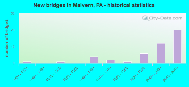
- New bridges - historical statistics
- 11920-1929
- 11940-1949
- 41960-1969
- 21970-1979
- 11980-1989
- 61990-1999
- 122000-2009
- 202010-2019


- Bridge Condition - Deck
- 28.6%Very good
- 42.9%Good
- 9.5%Satisfactory
- 19.0%Fair

- Bridge Condition - Superstructure
- 4.8%Excellent
- 33.3%Very good
- 38.1%Good
- 14.3%Satisfactory
- 9.5%Fair

- Bridge Condition - Substructure
- 14.3%Very good
- 42.9%Good
- 33.3%Satisfactory
- 9.5%Fair

- Bridge Condition - Channel
- 15.4%Satisfactory
- 69.2%Fair
- 15.4%Poor

- Bridge Condition - Culverts
- 62.5%Good
- 37.5%Satisfactory
Find on map >> Show street view
Structure Number: 9952, Location: NEAR VALLEY STORE 23B06 (Lat: 40.058789, Lng: -75.530608), Route carried "on" structure: State highway 29, Year Built: 1964, Status: Open, Structure Length: 0.73m (2.40ft), Average Daily Traffic: 28,284 (year 2022), Truck Traffic: 10%, Average Future Daily Traffic: 27,240 (year 2032), Design Load: HS 20, Features Intersected: VALLEY CREEK, Facility Carried by Structure: MOREHALL ROAD
Minimum Vertical Clearance: 30+ m (98+ ft), Kilometerpoint: 1.822, Lanes on structure: 2, Owner: State Highway Agency, Approaching Roadway Width: 25.6m (84.0ft), Skew: 21 degrees, Material/Design: Concrete, Design/Construction: Culvert, Number Of Spans In Main Unit: 1, Length of Maximum Span: 7.3m (24.0ft)
Condition: Channel: Fair, Culverts: Satisfactory, Inventory Rating: 78.9 metric tons, Method Used To Determine Inventory Rating: Load Factor (LF), Structural Evaluation: Equal to present minimum criteria, Waterway Adequacy: Superior to present desirable criteria, Approach Roadway Alignment: Equal to present desirable criteria, Length Of Structure Improvement: 1.50m (4.92ft), Designated Inspection Frequency: Every 24 months, Inspection Date: October 2020
Find on map >> Show street view
Structure Number: 10132, Location: MALVERN 22H7 (Lat: 40.051547, Lng: -75.561231), Route carried "on" structure: US 202, Year Built: 1967, Status: Open, Structure Length: 0.79m (2.59ft), Average Daily Traffic: 80,160 (year 2020), Truck Traffic: 11%, Average Future Daily Traffic: 85,771 (year 2032), Design Load: HS 20, Features Intersected: BRANCH VALLEY CREEK
Minimum Vertical Clearance: 30+ m (98+ ft), Kilometerpoint: 18.630, Lanes on structure: 3, Base Highway Network: Yes, Owner: State Highway Agency, Approaching Roadway Width: 28.0m (91.9ft), Skew: 24 degrees, Material/Design: Concrete, Design/Construction: Culvert, Number Of Spans In Main Unit: 1, Length of Maximum Span: 7.9m (25.9ft)
Condition: Channel: Fair, Culverts: Satisfactory, Operating Rating: 88.0 metric tons, Method Used To Determine Operating Rating: Load Factor (LF), Inventory Rating: 52.6 metric tons, Method Used To Determine Inventory Rating: Load Factor (LF), Structural Evaluation: Equal to present minimum criteria, Waterway Adequacy: Superior to present desirable criteria, Approach Roadway Alignment: Equal to present desirable criteria, Length Of Structure Improvement: 1.40m (4.59ft), Designated Inspection Frequency: Every 24 months, Inspection Date: September 2020
Find on map >> Show street view
Structure Number: 10219, Location: 2.0 MI TO FRAZER 32K5 (Lat: 39.991319, Lng: -75.543456), Route carried "on" structure: State highway 352, Year Built: 1966, Status: Open, Structure Length: 1.28m (4.20ft), Average Daily Traffic: 7,180 (year 2022), Truck Traffic: 7%, Average Future Daily Traffic: 10,287 (year 2032), Design Load: HS 20, Features Intersected: RIDLEY CREEK, Facility Carried by Structure: CHESTER ROAD
Minimum Vertical Clearance: 30+ m (98+ ft), Kilometerpoint: 4.878, Lanes on structure: 2, Owner: State Highway Agency, Approaching Roadway Width: 12.2m (40.0ft), Material/Design: Prestressed concrete, Design/Construction: Box Beam or Girders - Multiple, Number Of Spans In Main Unit: 1, Length of Maximum Span: 12.5m (41.0ft), Curb or Sidewalk Widths: Left: 0.5m (1.6ft), Right: 0.5m (1.6ft), Curb-To-Curb Width: 11.6m (38.1ft), Out-to-Out Width: 13.4m (44.0ft)
Condition: Deck: Fair, Superstructure: Good, Substructure: Fair, Channel: Fair, Operating Rating: 62.6 metric tons, Method Used To Determine Operating Rating: Load Factor (LF), Inventory Rating: 29.9 metric tons, Method Used To Determine Inventory Rating: Load Factor (LF), Structural Evaluation: Somewhat better than minimum adequacy, Deck Geometry: Somewhat better than minimum adequacy, Waterway Adequacy: Equal to present minimum criteria, Approach Roadway Alignment: Equal to present desirable criteria, Length Of Structure Improvement: 2.10m (6.89ft), Designated Inspection Frequency: Every 24 months, Inspection Date: September 2020, Bridge Improvement Cost: $11,000, Roadway Improvement Cost: $32,000, Total Project Cost: $147,000, Deck Structure Type: Concrete Cast-file-Place, Wearing Surface/Protective System: Wearing Surface: Bituminous
Find on map >> Show street view
Structure Number: 10221, Location: FRAZER S. US 30 22H10 (Lat: 40.036033, Lng: -75.559017), Route carried "on" structure: State highway 352, Year Built: 1998, Status: Open, Structure Length: 1.52m (4.99ft), Average Daily Traffic: 10,197 (year 2022), Truck Traffic: 3%, Average Future Daily Traffic: 12,148 (year 2032), Design Load: HS 25 or greater, Features Intersected: NSRC (EARNEST-GLEN), Facility Carried by Structure: SPROUL ROAD
Minimum Vertical Clearance: 30+ m (98+ ft), Kilometerpoint: 10.437, Lanes on structure: 3, Owner: State Highway Agency, Approaching Roadway Width: 11.9m (39.0ft), Skew: 1 degrees, Material/Design: Prestressed concrete, Design/Construction: Box Beam or Girders - Multiple, Number Of Spans In Main Unit: 1, Length of Maximum Span: 14.6m (47.9ft), Curb or Sidewalk Widths: Left: 2.1m (6.9ft), Right: 0.2m (0.7ft), Curb-To-Curb Width: 12.2m (40.0ft), Out-to-Out Width: 13.3m (43.6ft)
Condition: Deck: Satisfactory, Superstructure: Satisfactory, Substructure: Satisfactory, Inventory Rating: 57.2 metric tons, Method Used To Determine Inventory Rating: Load Factor (LF), Structural Evaluation: Equal to present minimum criteria, Deck Geometry: Meets minimum limits, Underclear: High priority of corrective action, Approach Roadway Alignment: Somewhat better than minimum adequacy, Length Of Structure Improvement: 3.30m (10.83ft), Designated Inspection Frequency: Every 24 months, Inspection Date: October 2019, Bridge Improvement Cost: $59,000, Roadway Improvement Cost: $175,000, Total Project Cost: $800,000, Deck Structure Type: Concrete Cast-file-Place, Wearing Surface/Protective System: Wearing Surface: Monolithic Concrete, Deck Protection: Epoxy Coated Reinforcing
Find on map >> Show street view
Structure Number: 10295, Location: CHESTER VALLEY 23B07 (Lat: 40.049556, Lng: -75.535528), Route carried "on" structure: State highway , Year Built: 1969, Status: Open, Structure Length: 1.16m (3.81ft), Average Daily Traffic: 7,965 (year 2022), Truck Traffic: 3%, Average Future Daily Traffic: 11,618 (year 2032), Design Load: HS 20, Features Intersected: CONRAIL(ABANDONED), Facility Carried by Structure: SWEDESFORD ROAD
Minimum Vertical Clearance: 30+ m (98+ ft), Kilometerpoint: 3.462, Lanes on structure: 2, Owner: State Highway Agency, Approaching Roadway Width: 12.2m (40.0ft), Skew: 2 degrees, Material/Design: Prestressed concrete, Design/Construction: Box Beam or Girders - Single/Spread, Number Of Spans In Main Unit: 1, Length of Maximum Span: 11.0m (36.1ft), Curb or Sidewalk Widths: Left: 0.9m (3.0ft), Right: 1.5m (4.9ft), Curb-To-Curb Width: 12.3m (40.4ft), Out-to-Out Width: 15.1m (49.5ft)
Condition: Deck: Fair, Superstructure: Good, Substructure: Satisfactory, Operating Rating: 63.5 metric tons, Method Used To Determine Operating Rating: Load Factor (LF), Inventory Rating: 34.5 metric tons, Method Used To Determine Inventory Rating: Load Factor (LF), Structural Evaluation: Equal to present minimum criteria, Deck Geometry: Somewhat better than minimum adequacy, Approach Roadway Alignment: Equal to present desirable criteria, Length Of Structure Improvement: 1.80m (5.91ft), Designated Inspection Frequency: Every 24 months, Inspection Date: July 2020, Deck Structure Type: Concrete Cast-file-Place, Wearing Surface/Protective System: Wearing Surface: Monolithic Concrete
Find on map >> Show street view
Structure Number: 10302, Location: 1.7 MI. N. SR 30 22F6 (Lat: 40.054408, Lng: -75.570725), Route carried "on" structure: State highway , Year Built: 1996, Status: Open, Structure Length: 0.91m (2.99ft), Average Daily Traffic: 15,676 (year 2022), Truck Traffic: 4%, Average Future Daily Traffic: 14,147 (year 2032), Design Load: HS 25 or greater, Features Intersected: VALLEY CREEK, Facility Carried by Structure: PHOENIXVILLE PIKE
Minimum Vertical Clearance: 30+ m (98+ ft), Kilometerpoint: 0.005, Lanes on structure: 3, Owner: State Highway Agency, Approaching Roadway Width: 13.4m (44.0ft), Skew: 1 degrees, Material/Design: Concrete, Design/Construction: Culvert, Number Of Spans In Main Unit: 2, Length of Maximum Span: 4.3m (14.1ft)
Condition: Channel: Fair, Culverts: Good, Operating Rating: 74.4 metric tons, Method Used To Determine Operating Rating: Load Factor (LF), Inventory Rating: 44.5 metric tons, Method Used To Determine Inventory Rating: Load Factor (LF), Structural Evaluation: Better than present minimum criteria, Waterway Adequacy: Equal to present minimum criteria, Approach Roadway Alignment: Equal to present desirable criteria, Length Of Structure Improvement: 1.60m (5.25ft), Designated Inspection Frequency: Every 24 months, Inspection Date: September 2020
Find on map >> Show street view
Structure Number: 10387, Location: .7 MI. EAST PA 352 33D7 (Lat: 39.980917, Lng: -75.516831), Route carried "on" structure: State highway , Year Built: 1970, Status: Open, Structure Length: 1.74m (5.71ft), Average Daily Traffic: 2,736 (year 2021), Truck Traffic: 7%, Average Future Daily Traffic: 4,027 (year 2032), Design Load: HS 20, Features Intersected: RIDLEY CREEK, Facility Carried by Structure: EAST STRASBURG RD
Minimum Vertical Clearance: 30+ m (98+ ft), Kilometerpoint: 3.980, Lanes on structure: 2, Owner: State Highway Agency, Approaching Roadway Width: 6.7m (22.0ft), Material/Design: Prestressed concrete, Design/Construction: Box Beam or Girders - Single/Spread, Number Of Spans In Main Unit: 1, Length of Maximum Span: 16.8m (55.1ft), Curb or Sidewalk Widths: Left: 0.2m (0.7ft), Right: 0.2m (0.7ft), Curb-To-Curb Width: 13.4m (44.0ft), Out-to-Out Width: 14.7m (48.2ft)
Condition: Deck: Fair, Superstructure: Fair, Substructure: Satisfactory, Channel: Fair, Operating Rating: 44.5 metric tons, Method Used To Determine Operating Rating: Load Factor (LF), Inventory Rating: 26.3 metric tons, Method Used To Determine Inventory Rating: Load Factor (LF), Structural Evaluation: Somewhat better than minimum adequacy, Deck Geometry: Better than present minimum criteria, Waterway Adequacy: Better than present minimum criteria, Approach Roadway Alignment: Equal to present desirable criteria, Length Of Structure Improvement: 2.40m (7.87ft), Designated Inspection Frequency: Every 24 months, Inspection Date: May 2021, Deck Structure Type: Concrete Cast-file-Place, Wearing Surface/Protective System: Wearing Surface: Monolithic Concrete
Find on map >> Show street view
Structure Number: 10394, Location: W. OF RTE. 352 32J5 (Lat: 39.990931, Lng: -75.549286), Route carried "on" structure: State highway , Year Built: 1998, Status: Open, Structure Length: 1.22m (4.00ft), Average Daily Traffic: 11,125 (year 2022), Truck Traffic: 17%, Average Future Daily Traffic: 14,454 (year 2032), Design Load: HS 25 or greater, Features Intersected: W. BR. RIDLEY CREEK, Facility Carried by Structure: PAOLI PIKE
Minimum Vertical Clearance: 30+ m (98+ ft), Kilometerpoint: 4.435, Lanes on structure: 3, Owner: State Highway Agency, Approaching Roadway Width: 16.5m (54.1ft), Skew: 20 degrees, Material/Design: Concrete, Design/Construction: Culvert, Number Of Spans In Main Unit: 2, Length of Maximum Span: 5.5m (18.0ft), Curb-To-Curb Width: 16.5m (54.1ft), Out-to-Out Width: 17.6m (57.7ft)
Condition: Channel: Fair, Culverts: Good, Operating Rating: 47.2 metric tons, Method Used To Determine Operating Rating: Load Factor (LF), Inventory Rating: 28.1 metric tons, Method Used To Determine Inventory Rating: Load Factor (LF), Structural Evaluation: Better than present minimum criteria, Deck Geometry: Better than present minimum criteria, Waterway Adequacy: Equal to present minimum criteria, Approach Roadway Alignment: Equal to present desirable criteria, Length Of Structure Improvement: 1.20m (3.94ft), Designated Inspection Frequency: Every 24 months, Inspection Date: September 2021, Bridge Improvement Cost: $42,000, Roadway Improvement Cost: $122,000, Total Project Cost: $561,000, Wearing Surface/Protective System: Wearing Surface: Bituminous
Find on map >> Show street view
Structure Number: 10395, Location: 1MI.E.CHESTER RD. 33A02 (Lat: 40.007875, Lng: -75.536394), Route carried "on" structure: State highway , Year Built: 1946, Status: Open, Structure Length: 0.64m (2.10ft), Average Daily Traffic: 7,480 (year 2021), Truck Traffic: 5%, Average Future Daily Traffic: 13,882 (year 2032), Design Load: H 20, Features Intersected: BRANCH RIDLEY CREEK, Facility Carried by Structure: PAOLI PIKE
Minimum Vertical Clearance: 30+ m (98+ ft), Kilometerpoint: 6.659, Lanes on structure: 2, Owner: State Highway Agency, Approaching Roadway Width: 9.8m (32.2ft), Material/Design: Concrete, Design/Construction: Slab, Number Of Spans In Main Unit: 1, Length of Maximum Span: 5.5m (18.0ft), Curb-To-Curb Width: 10.3m (33.8ft), Out-to-Out Width: 10.4m (34.1ft)
Condition: Deck: Satisfactory, Superstructure: Satisfactory, Substructure: Satisfactory, Channel: Poor, Operating Rating: 61.7 metric tons, Method Used To Determine Operating Rating: Field evaluation and documented engineering judgment, Inventory Rating: 36.3 metric tons, Method Used To Determine Inventory Rating: Field evaluation and documented engineering judgment, Structural Evaluation: Equal to present minimum criteria, Deck Geometry: Meets minimum limits, Waterway Adequacy: Somewhat better than minimum adequacy, Approach Roadway Alignment: Equal to present desirable criteria, Length Of Structure Improvement: 1.20m (3.94ft), Designated Inspection Frequency: Every 24 months, Inspection Date: July 2020, Deck Structure Type: Concrete Cast-file-Place, Wearing Surface/Protective System: Wearing Surface: Bituminous
Find on map >> Show street view
Structure Number: 10704, Location: E GOSHEN TWP 3584-H4 (Lat: 39.980336, Lng: -75.514089), Route carried "on" structure: City street , Year Built: 1922, Status: Posted for load, Structure Length: 0.98m (3.22ft), Average Daily Traffic: 1,886 (year 2018), Truck Traffic: 7%, Average Future Daily Traffic: 2,075 (year 2023), Features Intersected: RIDLEY CREEK, Facility Carried by Structure: DUTTON MILL ROAD
Minimum Vertical Clearance: 30+ m (98+ ft), Kilometerpoint: 0.000, Lanes on structure: 1, Owner: County Highway Agency, Approaching Roadway Width: 6.1m (20.0ft), Material/Design: Concrete, Design/Construction: Tee Beam, Number Of Spans In Main Unit: 1, Length of Maximum Span: 8.2m (26.9ft), Curb-To-Curb Width: 5.6m (18.4ft), Out-to-Out Width: 6.1m (20.0ft)
Condition: Deck: Fair, Superstructure: Fair, Substructure: Fair, Channel: Poor, Operating Rating: 27.2 metric tons, Method Used To Determine Operating Rating: Load Factor (LF), Inventory Rating: 16.3 metric tons, Method Used To Determine Inventory Rating: Load Factor (LF), Structural Evaluation: Meets minimum limits, Deck Geometry: High priority of replacement, Waterway Adequacy: Better than present minimum criteria, Approach Roadway Alignment: Equal to present minimum criteria, Bridge Posting: Required (Relationship of Operating Rating to Maximum Legal Load: > 39.9% below), Length Of Structure Improvement: 1.60m (5.25ft), Designated Inspection Frequency: Every 24 months, Other Special Inspection Frequency: Every 12 months, Inspection Date: March 2021, Other Special Inspection Date: August 2021, Bridge Improvement Cost: $27,000, Roadway Improvement Cost: $79,000, Total Project Cost: $363,000, Deck Structure Type: Concrete Cast-file-Place, Wearing Surface/Protective System: Wearing Surface: Bituminous
Find on map >> Show street view
Structure Number: 10753, Location: NEAR DEVAULT (Lat: 40.076725, Lng: -75.539333), Route carried "on" structure: Interstate 76, Year Built: 2003, Status: Open, Structure Length: 8.35m (27.40ft), Average Daily Traffic: 42,480 (year 2001), Truck Traffic: 20%, Average Future Daily Traffic: 52,230 (year 2030), Design Load: HS 20, Features Intersected: SR1003,NORFOLK SOUTHERN
Minimum Vertical Clearance: 30+ m (98+ ft), Kilometerpoint: 0.000, Lanes on structure: 4, Lanes under structure: 2, Base Highway Network: Yes, Toll: On toll road, Owner: State Toll Authority, Approaching Roadway Width: 34.1m (111.9ft), Skew: 36 degrees, Material/Design: Steel continuous, Design/Construction: Stringer/Multi-beam, Number Of Spans In Main Unit: 2, Length of Maximum Span: 42.7m (140.1ft), Curb or Sidewalk Widths: Left: 0.1m (0.3ft), Right: 0.1m (0.3ft), Curb-To-Curb Width: 34.3m (112.5ft), Out-to-Out Width: 36.0m (118.1ft)
Condition: Deck: Good, Superstructure: Good, Substructure: Satisfactory, Operating Rating: 54.4 metric tons, Method Used To Determine Operating Rating: Load Factor (LF), Inventory Rating: 32.7 metric tons, Method Used To Determine Inventory Rating: Load Factor (LF), Structural Evaluation: Equal to present minimum criteria, Deck Geometry: Superior to present desirable criteria, Underclear: Somewhat better than minimum adequacy, Approach Roadway Alignment: Equal to present desirable criteria, Length Of Structure Improvement: 9.40m (30.84ft), Designated Inspection Frequency: Every 48 months, Inspection Date: May 2019, Bridge Improvement Cost: $150,000, Roadway Improvement Cost: $442,000, Total Project Cost: $2,026,000, Deck Structure Type: Concrete Cast-file-Place, Wearing Surface/Protective System: Wearing Surface: Monolithic Concrete, Deck Protection: Epoxy Coated Reinforcing
Find on map >> Show street view
Structure Number: 10754, Location: EAST OF DEVAULT (Lat: 40.076267, Lng: -75.537069), Route carried "on" structure: Interstate 76, Year Built: 2002, Status: Open, Structure Length: 3.26m (10.70ft), Average Daily Traffic: 42,480 (year 2001), Truck Traffic: 20%, Average Future Daily Traffic: 52,230 (year 2030), Design Load: HS 20, Features Intersected: SR 0029, LR15050
Minimum Vertical Clearance: 30+ m (98+ ft), Kilometerpoint: 0.000, Lanes on structure: 5, Lanes under structure: 4, Base Highway Network: Yes, Toll: On toll road, Owner: State Toll Authority, Approaching Roadway Width: 34.1m (111.9ft), Skew: 34 degrees, Material/Design: Steel, Design/Construction: Stringer/Multi-beam, Number Of Spans In Main Unit: 1, Length of Maximum Span: 30.5m (100.1ft), Curb or Sidewalk Widths: Left: 0.1m (0.3ft), Right: 0.1m (0.3ft), Curb-To-Curb Width: 34.2m (112.2ft), Out-to-Out Width: 36.0m (118.1ft)
Condition: Deck: Good, Superstructure: Satisfactory, Substructure: Good, Operating Rating: 66.2 metric tons, Method Used To Determine Operating Rating: Load Factor (LF), Inventory Rating: 39.9 metric tons, Method Used To Determine Inventory Rating: Load Factor (LF), Structural Evaluation: Equal to present minimum criteria, Deck Geometry: Superior to present desirable criteria, Underclear: High priority of corrective action, Approach Roadway Alignment: Equal to present desirable criteria, Length Of Structure Improvement: 1.60m (5.25ft), Designated Inspection Frequency: Every 48 months, Inspection Date: May 2019, Bridge Improvement Cost: $30,000, Roadway Improvement Cost: $89,000, Total Project Cost: $408,000, Deck Structure Type: Concrete Cast-file-Place, Wearing Surface/Protective System: Wearing Surface: Monolithic Concrete, Deck Protection: Epoxy Coated Reinforcing
Find on map >> Show street view
Structure Number: 10781, Location: 0.25 Mi E PA 352 3584-D2 (Lat: 39.992936, Lng: -75.539319), Route carried "on" structure: City street , Year Built: 1970, Status: Open, Structure Length: 0.88m (2.89ft), Average Daily Traffic: 970 (year 1989), Average Future Daily Traffic: 1,400 (year 2033), Design Load: HL 93, Features Intersected: RIDLEY CREEK, Facility Carried by Structure: EAST BOOT ROAD
Minimum Vertical Clearance: 30+ m (98+ ft), Kilometerpoint: 0.000, Lanes on structure: 2, Owner: Town or Township Highway Agency, Approaching Roadway Width: 6.7m (22.0ft), Material/Design: Prestressed concrete, Design/Construction: Box Beam or Girders - Multiple, Number Of Spans In Main Unit: 1, Length of Maximum Span: 8.2m (26.9ft), Curb or Sidewalk Widths: Left: 1.5m (4.9ft), Right: 0.0m, Curb-To-Curb Width: 7.4m (24.3ft), Out-to-Out Width: 10.1m (33.1ft)
Condition: Deck: Very good, Superstructure: Excellent, Substructure: Good, Channel: Satisfactory, Operating Rating: 73.5 metric tons, Method Used To Determine Operating Rating: Load and Resistance Factor (LRFR), Inventory Rating: 48.1 metric tons, Method Used To Determine Inventory Rating: Load and Resistance Factor (LRFR), Structural Evaluation: Better than present minimum criteria, Deck Geometry: Meets minimum limits, Waterway Adequacy: Equal to present minimum criteria, Approach Roadway Alignment: Equal to present desirable criteria, Length Of Structure Improvement: 1.10m (3.61ft), Designated Inspection Frequency: Every 24 months, Inspection Date: June 2020, Bridge Improvement Cost: $8,000, Total Project Cost: $113,000, Deck Structure Type: Concrete Cast-file-Place, Wearing Surface/Protective System: Wearing Surface: Monolithic Concrete, Deck Protection: Epoxy Coated Reinforcing
Find on map >> Show street view
Structure Number: 10792, Location: .4 Mi N US-202 3474-E1 (Lat: 40.057578, Lng: -75.531250), Route carried "on" structure: City street , Year Built: 1987, Status: Open, Structure Length: 1.01m (3.31ft), Average Daily Traffic: 420 (year 2012), Truck Traffic: 2%, Average Future Daily Traffic: 500 (year 2032), Design Load: HS 25 or greater, Features Intersected: VALLEY CREEK, Facility Carried by Structure: OLD MOREHALL ROAD
Minimum Vertical Clearance: 30+ m (98+ ft), Kilometerpoint: 0.000, Lanes on structure: 2, Owner: Town or Township Highway Agency, Approaching Roadway Width: 7.0m (23.0ft), Material/Design: Concrete, Design/Construction: Culvert, Number Of Spans In Main Unit: 3, Length of Maximum Span: 3.0m (9.8ft), Curb-To-Curb Width: 6.9m (22.6ft), Out-to-Out Width: 7.9m (25.9ft)
Condition: Channel: Fair, Culverts: Satisfactory, Operating Rating: 83.5 metric tons, Method Used To Determine Operating Rating: Load Factor (LF), Inventory Rating: 49.9 metric tons, Method Used To Determine Inventory Rating: Load Factor (LF), Structural Evaluation: Equal to present minimum criteria, Deck Geometry: Meets minimum limits, Waterway Adequacy: Meets minimum limits, Approach Roadway Alignment: Equal to present desirable criteria, Length Of Structure Improvement: 1.20m (3.94ft), Designated Inspection Frequency: Every 24 months, Inspection Date: June 2020, Wearing Surface/Protective System: Wearing Surface: Bituminous
Find on map >> Show street view
Structure Number: 10867, Location: 2000' S OF RT 30 3474-J5 (Lat: 40.037197, Lng: -75.512900), Route carried "on" structure: City street , Year Built: 1991, Status: Open, Structure Length: 1.86m (6.10ft), Average Daily Traffic: 1,500 (year 2019), Truck Traffic: 1%, Average Future Daily Traffic: 1,750 (year 2039), Design Load: HS 25 or greater, Features Intersected: AMTRAK (HBSG. BRANCH), Facility Carried by Structure: BRIDGE STREET
Minimum Vertical Clearance: 30+ m (98+ ft), Kilometerpoint: 0.000, Lanes on structure: 2, Owner: City or Municipal Highway Agency, Approaching Roadway Width: 8.8m (28.9ft), Material/Design: Prestressed concrete, Design/Construction: Box Beam or Girders - Multiple, Number Of Spans In Main Unit: 1, Length of Maximum Span: 18.3m (60.0ft), Curb or Sidewalk Widths: Left: 1.6m (5.2ft), Right: 0.2m (0.7ft), Curb-To-Curb Width: 8.9m (29.2ft), Out-to-Out Width: 11.3m (37.1ft)
Condition: Deck: Good, Superstructure: Good, Substructure: Good, Inventory Rating: 56.2 metric tons, Method Used To Determine Inventory Rating: Load Factor (LF), Structural Evaluation: Better than present minimum criteria, Deck Geometry: Somewhat better than minimum adequacy, Underclear: High priority of corrective action, Approach Roadway Alignment: Better than present minimum criteria, Length Of Structure Improvement: 2.50m (8.20ft), Designated Inspection Frequency: Every 24 months, Inspection Date: March 2021, Deck Structure Type: Concrete Cast-file-Place, Wearing Surface/Protective System: Wearing Surface: Monolithic Concrete, Deck Protection: Epoxy Coated Reinforcing
Find on map >> Show street view
Structure Number: 44297, Location: .4 MI. N OF PA 401 22J7 (Lat: 40.051847, Lng: -75.555022), Route carried "on" structure: State highway , Year Built: 2007, Status: Open, Structure Length: 4.69m (15.39ft), Average Daily Traffic: 2,064 (year 2021), Truck Traffic: 3%, Average Future Daily Traffic: 2,483 (year 2032), Design Load: HL 93, Features Intersected: US ROUTE 202, Facility Carried by Structure: MILL LANE (T488)
Minimum Vertical Clearance: 30+ m (98+ ft), Kilometerpoint: 0.000, Lanes on structure: 2, Lanes under structure: 4, Owner: State Highway Agency, Approaching Roadway Width: 11.3m (37.1ft), Skew: 1 degrees, Material/Design: Prestressed concrete continuous, Design/Construction: Box Beam or Girders - Single/Spread, Number Of Spans In Main Unit: 2, Length of Maximum Span: 23.2m (76.1ft), Curb or Sidewalk Widths: Left: 1.5m (4.9ft), Right: 0.2m (0.7ft), Curb-To-Curb Width: 11.0m (36.1ft), Out-to-Out Width: 13.4m (44.0ft)
Condition: Deck: Good, Superstructure: Good, Substructure: Good, Operating Rating: 71.7 metric tons, Method Used To Determine Operating Rating: Load Factor (LF), Inventory Rating: 36.3 metric tons, Method Used To Determine Inventory Rating: Load Factor (LF), Structural Evaluation: Better than present minimum criteria, Deck Geometry: Somewhat better than minimum adequacy, Underclear: Equal to present minimum criteria, Approach Roadway Alignment: Better than present minimum criteria, Designated Inspection Frequency: Every 24 months, Inspection Date: December 2019, Deck Structure Type: Concrete Cast-file-Place, Wearing Surface/Protective System: Wearing Surface: Monolithic Concrete, Membrane: Epoxy, Deck Protection: Epoxy Coated Reinforcing
Find on map >> Show street view
Structure Number: 44451, Location: NEAR 401 22G7 / 3473K3 (Lat: 40.049619, Lng: -75.565281), Route carried "on" structure: State highway , Year Built: 2008, Status: Open, Structure Length: 6.16m (20.21ft), Average Daily Traffic: 3,588 (year 2021), Truck Traffic: 4%, Average Future Daily Traffic: 3,033 (year 2032), Design Load: HL 93, Features Intersected: US-202 BYPASS;RAMP M, Facility Carried by Structure: CHURCH ROAD
Minimum Vertical Clearance: 30+ m (98+ ft), Kilometerpoint: 0.000, Lanes on structure: 2, Lanes under structure: 6, Owner: State Highway Agency, Approaching Roadway Width: 12.2m (40.0ft), Skew: 1 degrees, Material/Design: Prestressed concrete continuous, Design/Construction: Box Beam or Girders - Single/Spread, Number Of Spans In Main Unit: 2, Length of Maximum Span: 30.2m (99.1ft), Curb or Sidewalk Widths: Left: 0.0m, Right: 1.5m (4.9ft), Curb-To-Curb Width: 11.0m (36.1ft), Out-to-Out Width: 13.3m (43.6ft)
Condition: Deck: Good, Superstructure: Good, Substructure: Satisfactory, Operating Rating: 90.7 metric tons, Method Used To Determine Operating Rating: Load Factor (LF), Inventory Rating: 30.8 metric tons, Method Used To Determine Inventory Rating: Load Factor (LF), Structural Evaluation: Equal to present minimum criteria, Deck Geometry: Somewhat better than minimum adequacy, Underclear: Better than present minimum criteria, Approach Roadway Alignment: Better than present minimum criteria, Designated Inspection Frequency: Every 24 months, Inspection Date: November 2020, Deck Structure Type: Concrete Cast-file-Place, Wearing Surface/Protective System: Wearing Surface: Monolithic Concrete, Deck Protection: Epoxy Coated Reinforcing
Find on map >> Show street view
Structure Number: 45814, Location: .4MI. S.PA29 INT. 3474E02 (Lat: 40.051633, Lng: -75.533417), Route carried "on" structure: State highway , Year Built: 2010, Status: Open, Structure Length: 6.89m (22.60ft), Average Daily Traffic: 12,607 (year 2022), Truck Traffic: 6%, Average Future Daily Traffic: 14,744 (year 2032), Design Load: HL 93, Features Intersected: US RTE 202, Facility Carried by Structure: SWEDESFORD ROAD
Minimum Vertical Clearance: 30+ m (98+ ft), Kilometerpoint: 3.967, Lanes on structure: 3, Lanes under structure: 7, Owner: State Highway Agency, Approaching Roadway Width: 17.1m (56.1ft), Skew: 3 degrees, Material/Design: Prestressed concrete, Design/Construction: Box Beam or Girders - Single/Spread, Number Of Spans In Main Unit: 3, Length of Maximum Span: 23.5m (77.1ft), Curb or Sidewalk Widths: Left: 0.2m (0.7ft), Right: 1.5m (4.9ft), Curb-To-Curb Width: 17.1m (56.1ft), Out-to-Out Width: 19.4m (63.6ft)
Condition: Deck: Very good, Superstructure: Good, Substructure: Good, Operating Rating: 85.3 metric tons, Method Used To Determine Operating Rating: Load Factor (LF), Inventory Rating: 47.2 metric tons, Method Used To Determine Inventory Rating: Load Factor (LF), Structural Evaluation: Better than present minimum criteria, Deck Geometry: Superior to present desirable criteria, Underclear: Equal to present minimum criteria, Approach Roadway Alignment: Equal to present minimum criteria, Designated Inspection Frequency: Every 24 months, Inspection Date: June 2020, Deck Structure Type: Concrete Cast-file-Place, Wearing Surface/Protective System: Wearing Surface: Monolithic Concrete, Deck Protection: Epoxy Coated Reinforcing
Find on map >> Show street view
Structure Number: 46025, Location: US202 /PA 29 INT. 3474F2 (Lat: 40.051389, Lng: -75.526361), Route carried "on" structure: State highway 29, Year Built: 2010, Status: Open, Structure Length: 6.71m (22.01ft), Average Daily Traffic: 25,224 (year 2022), Truck Traffic: 5%, Average Future Daily Traffic: 30,310 (year 2032), Design Load: HL 93, Features Intersected: US RTE 202, Facility Carried by Structure: MOREHALL ROAD
Minimum Vertical Clearance: 30+ m (98+ ft), Kilometerpoint: 0.621, Lanes on structure: 4, Lanes under structure: 7, Owner: State Highway Agency, Approaching Roadway Width: 31.1m (102.0ft), Skew: 23 degrees, Material/Design: Prestressed concrete, Design/Construction: Box Beam or Girders - Single/Spread, Number Of Spans In Main Unit: 3, Length of Maximum Span: 27.1m (88.9ft), Curb or Sidewalk Widths: Left: 1.5m (4.9ft), Right: 0.2m (0.7ft), Curb-To-Curb Width: 31.1m (102.0ft), Out-to-Out Width: 33.4m (109.6ft)
Condition: Deck: Good, Superstructure: Good, Substructure: Good, Operating Rating: 79.8 metric tons, Method Used To Determine Operating Rating: Load Factor (LF), Inventory Rating: 33.6 metric tons, Method Used To Determine Inventory Rating: Load Factor (LF), Structural Evaluation: Better than present minimum criteria, Deck Geometry: Superior to present desirable criteria, Underclear: High priority of corrective action, Approach Roadway Alignment: Equal to present desirable criteria, Designated Inspection Frequency: Every 24 months, Inspection Date: July 2020, Deck Structure Type: Concrete Cast-file-Place, Wearing Surface/Protective System: Wearing Surface: Monolithic Concrete, Membrane: Other, Deck Protection: Epoxy Coated Reinforcing
Find on map >> Show street view
Structure Number: 47713, Location: SR 29 Interchange (Lat: 40.073333, Lng: -75.533889), Route carried "on" structure: Ramp Interstate 76, Year Built: 2012, Status: Open, Structure Length: 10.67m (35.01ft), Average Daily Traffic: 2,000 (year 2013), Truck Traffic: 10%, Average Future Daily Traffic: 3,000 (year 2030), Design Load: HS 20, Features Intersected: Atwater Drive, Facility Carried by Structure: Ramp C
Minimum Vertical Clearance: 30+ m (98+ ft), Kilometerpoint: 514.250, Lanes on structure: 1, Lanes under structure: 4, Base Highway Network: Yes, Toll: On toll road, Owner: State Toll Authority, Approaching Roadway Width: 10.1m (33.1ft), Skew: 1 degrees, Material/Design: Steel, Design/Construction: Stringer/Multi-beam, Number Of Spans In Main Unit: 2, Length of Maximum Span: 68.9m (226.0ft), Curb or Sidewalk Widths: Left: 0.2m (0.7ft), Right: 0.2m (0.7ft), Curb-To-Curb Width: 10.1m (33.1ft), Out-to-Out Width: 10.5m (34.4ft)
Condition: Deck: Very good, Superstructure: Very good, Substructure: Good, Operating Rating: 79.9 metric tons, Method Used To Determine Operating Rating: Assigned ratings based on Load and Resistance Factor Design (LRFD) reported in metric tons, Inventory Rating: 48.1 metric tons, Method Used To Determine Inventory Rating: Assigned ratings based on Load and Resistance Factor Design (LRFD) reported in metric tons, Structural Evaluation: Better than present minimum criteria, Deck Geometry: Superior to present desirable criteria, Underclear: Meets minimum limits, Approach Roadway Alignment: Equal to present desirable criteria, Designated Inspection Frequency: Every 48 months, Inspection Date: November 2018, Deck Structure Type: Concrete Cast-file-Place, Wearing Surface/Protective System: Wearing Surface: Monolithic Concrete, Deck Protection: Epoxy Coated Reinforcing
Find on map >> Show street view
Structure Number: 47714, Location: SR 29 Interchange (Lat: 40.074167, Lng: -75.533333), Route carried "on" structure: Ramp Interstate 476, Year Built: 2012, Status: Open, Structure Length: 2.47m (8.10ft), Average Daily Traffic: 2,000 (year 2013), Truck Traffic: 10%, Average Future Daily Traffic: 3,000 (year 2030), Design Load: HL 93, Features Intersected: SR 1016, Facility Carried by Structure: Ramp C
Minimum Vertical Clearance: 30+ m (98+ ft), Kilometerpoint: 514.298, Lanes on structure: 1, Lanes under structure: 2, Base Highway Network: Yes, Toll: On toll road, Owner: State Toll Authority, Approaching Roadway Width: 10.1m (33.1ft), Material/Design: Steel, Design/Construction: Stringer/Multi-beam, Number Of Spans In Main Unit: 1, Length of Maximum Span: 24.4m (80.1ft), Curb or Sidewalk Widths: Left: 0.2m (0.7ft), Right: 0.2m (0.7ft), Curb-To-Curb Width: 10.1m (33.1ft), Out-to-Out Width: 10.5m (34.4ft)
Condition: Deck: Very good, Superstructure: Very good, Substructure: Very good, Operating Rating: 49.6 metric tons, Method Used To Determine Operating Rating: Assigned ratings based on Load and Resistance Factor Design (LRFD) reported by rating factor (RF) using HL93 loadings, Inventory Rating: 38.2 metric tons, Method Used To Determine Inventory Rating: Assigned ratings based on Load and Resistance Factor Design (LRFD) reported by rating factor (RF) using HL93 loadings, Structural Evaluation: Equal to present desirable criteria, Deck Geometry: Superior to present desirable criteria, Underclear: Superior to present desirable criteria, Approach Roadway Alignment: Equal to present desirable criteria, Designated Inspection Frequency: Every 48 months, Inspection Date: November 2018, Deck Structure Type: Concrete Cast-file-Place, Wearing Surface/Protective System: Wearing Surface: Integral Concrete, Deck Protection: Epoxy Coated Reinforcing
Find on map >> Show street view
Structure Number: 47715, Location: SR 29 Interchange (Lat: 40.074975, Lng: -75.530883), Route carried "on" structure: Ramp Interstate 76, Year Built: 2012, Status: Open, Structure Length: 28.59m (93.80ft), Average Daily Traffic: 2,000 (year 2013), Truck Traffic: 10%, Average Future Daily Traffic: 3,000 (year 2030), Design Load: HS 25 or greater, Features Intersected: SR 1016 & Atwater Drive, Facility Carried by Structure: Ramp AB & Ramp D
Minimum Vertical Clearance: 30+ m (98+ ft), Kilometerpoint: 0.000, Lanes on structure: 3, Lanes under structure: 6, Base Highway Network: Yes, Toll: On toll road, Owner: State Toll Authority, Approaching Roadway Width: 21.0m (68.9ft), Skew: 30 degrees, Material/Design: Steel continuous, Design/Construction: Stringer/Multi-beam, Number Of Spans In Main Unit: 10, Length of Maximum Span: 46.6m (152.9ft), Curb or Sidewalk Widths: Left: 0.2m (0.7ft), Right: 0.2m (0.7ft), Curb-To-Curb Width: 21.0m (68.9ft), Out-to-Out Width: 23.7m (77.8ft)
Condition: Deck: Very good, Superstructure: Very good, Substructure: Good, Operating Rating: 52.8 metric tons, Method Used To Determine Operating Rating: Assigned ratings based on Load and Resistance Factor Design (LRFD) reported by rating factor (RF) using HL93 loadings, Inventory Rating: 33.0 metric tons, Method Used To Determine Inventory Rating: Assigned ratings based on Load and Resistance Factor Design (LRFD) reported by rating factor (RF) using HL93 loadings, Structural Evaluation: Better than present minimum criteria, Deck Geometry: Superior to present desirable criteria, Underclear: Meets minimum limits, Approach Roadway Alignment: Equal to present desirable criteria, Designated Inspection Frequency: Every 48 months, Inspection Date: November 2018, Deck Structure Type: Concrete Cast-file-Place, Wearing Surface/Protective System: Wearing Surface: Monolithic Concrete, Deck Protection: Epoxy Coated Reinforcing
Find on map >> Show street view
Structure Number: 47716, Location: SR 29 Intercharge (Lat: 40.074708, Lng: -75.529539), Route carried "on" structure: Ramp Interstate , Year Built: 2012, Status: Open, Structure Length: 10.39m (34.09ft), Average Daily Traffic: 2,000 (year 2013), Truck Traffic: 10%, Average Future Daily Traffic: 3,000 (year 2030), Design Load: HL 93, Features Intersected: PA TPK (I-76), Facility Carried by Structure: Ramp AB
Minimum Vertical Clearance: 30+ m (98+ ft), Kilometerpoint: 0.000, Lanes on structure: 2, Lanes under structure: 5, Base Highway Network: Yes, Toll: On toll road, Owner: State Toll Authority, Approaching Roadway Width: 18.3m (60.0ft), Skew: 34 degrees, Material/Design: Steel continuous, Design/Construction: Stringer/Multi-beam, Number Of Spans In Main Unit: 4, Length of Maximum Span: 29.9m (98.1ft), Curb or Sidewalk Widths: Left: 0.2m (0.7ft), Right: 0.2m (0.7ft), Curb-To-Curb Width: 18.3m (60.0ft), Out-to-Out Width: 19.3m (63.3ft)
Condition: Deck: Good, Superstructure: Very good, Substructure: Very good, Operating Rating: 52.5 metric tons, Method Used To Determine Operating Rating: Assigned ratings based on Load and Resistance Factor Design (LRFD) reported by rating factor (RF) using HL93 loadings, Inventory Rating: 33.0 metric tons, Method Used To Determine Inventory Rating: Assigned ratings based on Load and Resistance Factor Design (LRFD) reported by rating factor (RF) using HL93 loadings, Structural Evaluation: Equal to present desirable criteria, Deck Geometry: Superior to present desirable criteria, Underclear: Superior to present desirable criteria, Approach Roadway Alignment: Somewhat better than minimum adequacy, Designated Inspection Frequency: Every 48 months, Inspection Date: November 2018, Deck Structure Type: Concrete Cast-file-Place, Wearing Surface/Protective System: Wearing Surface: Integral Concrete, Deck Protection: Epoxy Coated Reinforcing
Find on map >> Show street view
Structure Number: 48724, Location: 1 MILE N. U.S. 30 3473K0 (Lat: 40.045806, Lng: -75.568092), Route carried "on" structure: US 202, Year Built: 2016, Status: Open, Structure Length: 1.25m (4.10ft), Average Daily Traffic: 97,570 (year 2021), Truck Traffic: 6%, Average Future Daily Traffic: 85,700 (year 2032), Design Load: HL 93, Features Intersected: CHESTER VALLEY TRAIL
Minimum Vertical Clearance: 30+ m (98+ ft), Kilometerpoint: 17.778, Lanes on structure: 3, Base Highway Network: Yes, Owner: State Highway Agency, Approaching Roadway Width: 17.1m (56.1ft), Skew: 34 degrees, Material/Design: Concrete, Design/Construction: Culvert, Number Of Spans In Main Unit: 1, Length of Maximum Span: 6.1m (20.0ft)
Condition: Culverts: Good, Operating Rating: 97.2 metric tons, Method Used To Determine Operating Rating: Assigned ratings based on Load and Resistance Factor Design (LRFD) reported by rating factor (RF) using HL93 loadings, Inventory Rating: 96.9 metric tons, Method Used To Determine Inventory Rating: Assigned ratings based on Load and Resistance Factor Design (LRFD) reported by rating factor (RF) using HL93 loadings, Structural Evaluation: Better than present minimum criteria, Approach Roadway Alignment: Equal to present desirable criteria, Designated Inspection Frequency: Every 24 months, Inspection Date: April 2020
Find on map >> Show street view
Structure Number: 48888, Location: 1.5 MI. W. PA29 3474B02 (Lat: 40.051300, Lng: -75.551367), Route carried "on" structure: US 202, Year Built: 2014, Status: Open, Structure Length: 0.98m (3.22ft), Average Daily Traffic: 80,160 (year 2020), Truck Traffic: 11%, Average Future Daily Traffic: 85,771 (year 2032), Design Load: HL 93, Features Intersected: VALLEY CREEK
Minimum Vertical Clearance: 30+ m (98+ ft), Kilometerpoint: 19.882, Lanes on structure: 3, Base Highway Network: Yes, Owner: State Highway Agency, Approaching Roadway Width: 33.2m (108.9ft), Skew: 13 degrees, Material/Design: Prestressed concrete, Design/Construction: Box Beam or Girders - Single/Spread, Number Of Spans In Main Unit: 1, Length of Maximum Span: 9.1m (29.9ft), Curb-To-Curb Width: 33.2m (108.9ft), Out-to-Out Width: 35.8m (117.5ft)
Condition: Deck: Good, Superstructure: Very good, Substructure: Satisfactory, Channel: Fair, Operating Rating: 52.2 metric tons, Method Used To Determine Operating Rating: Assigned ratings based on Load and Resistance Factor Design (LRFD) reported by rating factor (RF) using HL93 loadings, Inventory Rating: 33.0 metric tons, Method Used To Determine Inventory Rating: Assigned ratings based on Load and Resistance Factor Design (LRFD) reported by rating factor (RF) using HL93 loadings, Structural Evaluation: Equal to present minimum criteria, Deck Geometry: Superior to present desirable criteria, Waterway Adequacy: Superior to present desirable criteria, Approach Roadway Alignment: Equal to present desirable criteria, Designated Inspection Frequency: Every 24 months, Inspection Date: October 2020, Deck Structure Type: Concrete Cast-file-Place, Wearing Surface/Protective System: Wearing Surface: Monolithic Concrete, Deck Protection: Epoxy Coated Reinforcing
Find on map >> Show street view
Structure Number: 53219, Location: 1.5 MI. N. US30 3473K02 (Lat: 40.051144, Lng: -75.562433), Route carried "on" structure: US 202, Year Built: 2016, Status: Open, Structure Length: 3.78m (12.40ft), Average Daily Traffic: 80,160 (year 2020), Truck Traffic: 11%, Average Future Daily Traffic: 82,778 (year 2032), Design Load: HL 93, Features Intersected: CONESTOGA ROAD (PA401)
Minimum Vertical Clearance: 30+ m (98+ ft), Kilometerpoint: 18.630, Lanes on structure: 3, Lanes under structure: 4, Base Highway Network: Yes, Owner: State Highway Agency, Approaching Roadway Width: 17.1m (56.1ft), Skew: 33 degrees, Material/Design: Prestressed concrete, Design/Construction: Stringer/Multi-beam, Number Of Spans In Main Unit: 1, Length of Maximum Span: 37.2m (122.0ft), Curb or Sidewalk Widths: Left: 0.1m (0.3ft), Right: 0.1m (0.3ft), Curb-To-Curb Width: 17.1m (56.1ft), Out-to-Out Width: 36.6m (120.1ft)
Condition: Deck: Good, Superstructure: Very good, Substructure: Good, Operating Rating: 55.7 metric tons, Method Used To Determine Operating Rating: Assigned ratings based on Load and Resistance Factor Design (LRFD) reported by rating factor (RF) using HL93 loadings, Inventory Rating: 38.9 metric tons, Method Used To Determine Inventory Rating: Assigned ratings based on Load and Resistance Factor Design (LRFD) reported by rating factor (RF) using HL93 loadings, Structural Evaluation: Better than present minimum criteria, Deck Geometry: Equal to present minimum criteria, Underclear: Equal to present minimum criteria, Approach Roadway Alignment: Equal to present desirable criteria, Designated Inspection Frequency: Every 24 months, Inspection Date: April 2020, Deck Structure Type: Concrete Cast-file-Place, Wearing Surface/Protective System: Wearing Surface: Monolithic Concrete, Deck Protection: Epoxy Coated Reinforcing
Find on map >> Show street view
Structure Number: 54187, Location: West of Line Road 3474D09 (Lat: 40.009667, Lng: -75.537958), Route carried "on" structure: City street , Year Built: 1990, Status: Open, Structure Length: 0.64m (2.10ft), Average Daily Traffic: 250 (year 2018), Truck Traffic: 4%, Average Future Daily Traffic: 305 (year 2038), Design Load: HS 25 or greater, Features Intersected: RIDLEY CREEK, Facility Carried by Structure: MADISON DRIVE
Minimum Vertical Clearance: 30+ m (98+ ft), Kilometerpoint: 0.000, Lanes on structure: 2, Owner: Town or Township Highway Agency, Approaching Roadway Width: 8.5m (27.9ft), Skew: 1 degrees, Material/Design: Concrete, Design/Construction: Culvert, Number Of Spans In Main Unit: 1, Length of Maximum Span: 6.4m (21.0ft), Curb-To-Curb Width: 10.2m (33.5ft), Out-to-Out Width: 15.2m (49.9ft)
Condition: Channel: Satisfactory, Culverts: Good, Operating Rating: 45.4 metric tons, Method Used To Determine Operating Rating: Load Factor (LF), Inventory Rating: 27.2 metric tons, Method Used To Determine Inventory Rating: Load Factor (LF), Structural Evaluation: Equal to present minimum criteria, Deck Geometry: Better than present minimum criteria, Waterway Adequacy: Equal to present desirable criteria, Approach Roadway Alignment: Equal to present desirable criteria, Designated Inspection Frequency: Every 24 months, Inspection Date: May 2021, Wearing Surface/Protective System: Wearing Surface: Bituminous
Find on map >> Show street view
Structure Number: 54255, Location: 1/2 MI. EAST PA352 3474D9 (Lat: 40.009644, Lng: -75.538403), Route carried "on" structure: City street , Year Built: 1990, Status: Open, Structure Length: 0.85m (2.79ft), Average Daily Traffic: 250 (year 2018), Truck Traffic: 4%, Average Future Daily Traffic: 305 (year 2038), Design Load: HS 25 or greater, Features Intersected: RIDLEY CREEK, Facility Carried by Structure: MADISON DRIVE
Minimum Vertical Clearance: 30+ m (98+ ft), Kilometerpoint: 0.000, Lanes on structure: 2, Owner: Town or Township Highway Agency, Approaching Roadway Width: 8.5m (27.9ft), Skew: 4 degrees, Material/Design: Concrete, Design/Construction: Culvert, Number Of Spans In Main Unit: 1, Length of Maximum Span: 6.4m (21.0ft), Curb-To-Curb Width: 8.5m (27.9ft), Out-to-Out Width: 8.8m (28.9ft)
Condition: Channel: Fair, Culverts: Good, Operating Rating: 45.4 metric tons, Method Used To Determine Operating Rating: Load Factor (LF), Inventory Rating: 27.2 metric tons, Method Used To Determine Inventory Rating: Load Factor (LF), Structural Evaluation: Equal to present minimum criteria, Deck Geometry: Equal to present minimum criteria, Waterway Adequacy: Better than present minimum criteria, Approach Roadway Alignment: Equal to present desirable criteria, Designated Inspection Frequency: Every 24 months, Inspection Date: May 2021
Find on map >> Show street view
Structure Number: 56079, Location: WEST OF DEVAULT (Lat: 40.069706, Lng: -75.571511), Route carried "on" structure: City street , Year Built: 2017, Status: Open, Structure Length: 6.71m (22.01ft), Average Daily Traffic: 200 (year 2014), Truck Traffic: 9%, Average Future Daily Traffic: 300 (year 2030), Design Load: HL 93, Features Intersected: PA TPK (I-76), Facility Carried by Structure: T-488 YellowSpring
Minimum Vertical Clearance: 30+ m (98+ ft), Kilometerpoint: 0.000, Lanes on structure: 2, Lanes under structure: 4, Owner: State Toll Authority, Approaching Roadway Width: 11.0m (36.1ft), Skew: 2 degrees, Material/Design: Steel continuous, Design/Construction: Stringer/Multi-beam, Number Of Spans In Main Unit: 2, Length of Maximum Span: 35.1m (115.2ft), Curb or Sidewalk Widths: Left: 0.2m (0.7ft), Right: 0.2m (0.7ft), Curb-To-Curb Width: 11.0m (36.1ft), Out-to-Out Width: 12.0m (39.4ft)
Condition: Deck: Very good, Superstructure: Very good, Substructure: Very good, Operating Rating: 55.7 metric tons, Method Used To Determine Operating Rating: Assigned ratings based on Load and Resistance Factor Design (LRFD) reported by rating factor (RF) using HL93 loadings, Inventory Rating: 43.1 metric tons, Method Used To Determine Inventory Rating: Assigned ratings based on Load and Resistance Factor Design (LRFD) reported by rating factor (RF) using HL93 loadings, Structural Evaluation: Equal to present desirable criteria, Deck Geometry: Equal to present desirable criteria, Underclear: Superior to present desirable criteria, Approach Roadway Alignment: Equal to present minimum criteria, Designated Inspection Frequency: Every 24 months, Inspection Date: November 2020, Deck Structure Type: Concrete Cast-file-Place, Wearing Surface/Protective System: Wearing Surface: Monolithic Concrete, Deck Protection: Epoxy Coated Reinforcing
Find on map >> Show street view
Structure Number: 10753, Location: NEAR DEVAULT (Lat: 40.076725, Lng: -75.539333), Route carried "under" structure: State highway , Year Built: 2003, Structure Length: 0. m, Average Daily Traffic: 8,624 (year 2020), Truck Traffic: 8%, Features Intersected: SR1003,NORFOLK SOUTHERN, Facility Carried by Structure: PA TPK (I-76)
Minimum Vertical Clearance: 8.61m (28.25ft), Kilometerpoint: 1.434, Lanes on structure: 4, Lanes under structure: 2, Material/Design: Steel continuous, Design/Construction: Stringer/Multi-beam, Length of Maximum Span: 42.7m (140.1ft)
Find on map >> Show street view
Structure Number: 10754, Location: EAST OF DEVAULT (Lat: 40.076267, Lng: -75.537069), Route carried "under" structure: State highway 29, Year Built: 2002, Structure Length: 0. m, Average Daily Traffic: 9,528 (year 2022), Truck Traffic: 10%, Features Intersected: SR 0029, LR15050, Facility Carried by Structure: PA TPK (I-76)
Minimum Vertical Clearance: 4.44m (14.57ft), Kilometerpoint: 3.787, Lanes on structure: 5, Lanes under structure: 2, Material/Design: Steel, Design/Construction: Stringer/Multi-beam, Length of Maximum Span: 30.5m (100.1ft)
Find on map >> Show street view
Structure Number: 10754, Location: EAST OF DEVAULT (Lat: 40.076267, Lng: -75.537069), Route carried "under" structure: State highway 29, Year Built: 2002, Structure Length: 0. m, Average Daily Traffic: 8,056 (year 2022), Truck Traffic: 10%, Features Intersected: SR 0029, LR15050, Facility Carried by Structure: PA TPK (I-76)
Minimum Vertical Clearance: 4.44m (14.57ft), Kilometerpoint: 3.784, Lanes on structure: 5, Lanes under structure: 2, Material/Design: Steel, Design/Construction: Stringer/Multi-beam, Length of Maximum Span: 30.5m (100.1ft)
Find on map >> Show street view
Structure Number: 44297, Location: .4 MI. N OF PA 401 22J7 (Lat: 40.051847, Lng: -75.555022), Route carried "under" structure: US 202, Year Built: 2007, Structure Length: 0. m, Average Daily Traffic: 41,770 (year 2020), Truck Traffic: 11%, Features Intersected: US ROUTE 202, Facility Carried by Structure: MILL LANE (T488)
Minimum Vertical Clearance: 5.18m (16.99ft), Kilometerpoint: 19.573, Lanes on structure: 2, Lanes under structure: 2, Material/Design: Prestressed concrete continuous, Design/Construction: Box Beam or Girders - Single/Spread, Length of Maximum Span: 23.2m (76.1ft)
Find on map >> Show street view
Structure Number: 44297, Location: .4 MI. N OF PA 401 22J7 (Lat: 40.051847, Lng: -75.555022), Route carried "under" structure: US 202, Year Built: 2007, Structure Length: 0. m, Average Daily Traffic: 38,390 (year 2020), Truck Traffic: 11%, Features Intersected: US ROUTE 202, Facility Carried by Structure: MILL LANE (T488)
Minimum Vertical Clearance: 5.54m (18.18ft), Kilometerpoint: 19.602, Lanes on structure: 2, Lanes under structure: 2, Material/Design: Prestressed concrete continuous, Design/Construction: Box Beam or Girders - Single/Spread, Length of Maximum Span: 23.2m (76.1ft)
Find on map >> Show street view
Structure Number: 44451, Location: NEAR 401 22G7 / 3473K3 (Lat: 40.049619, Lng: -75.565281), Route carried "under" structure: US 202, Year Built: 2008, Structure Length: 0. m, Average Daily Traffic: 38,390 (year 2020), Truck Traffic: 11%, Features Intersected: US-202 BYPASS;RAMP M, Facility Carried by Structure: CHURCH ROAD
Minimum Vertical Clearance: 6.35m (20.83ft), Kilometerpoint: 18.643, Lanes on structure: 2, Lanes under structure: 2, Material/Design: Prestressed concrete continuous, Design/Construction: Box Beam or Girders - Single/Spread, Length of Maximum Span: 30.2m (99.1ft)
Find on map >> Show street view
Structure Number: 44451, Location: NEAR 401 22G7 / 3473K3 (Lat: 40.049619, Lng: -75.565281), Route carried "under" structure: Ramp State highway , Year Built: 2008, Structure Length: 0. m, Average Daily Traffic: 5,433 (year 2022), Truck Traffic: 7%, Features Intersected: US-202 BYPASS;RAMP M, Facility Carried by Structure: CHURCH ROAD
Minimum Vertical Clearance: 5.28m (17.32ft), Kilometerpoint: 0.000, Lanes on structure: 2, Lanes under structure: 1, Material/Design: Prestressed concrete continuous, Design/Construction: Box Beam or Girders - Single/Spread, Length of Maximum Span: 30.2m (99.1ft)
Find on map >> Show street view
Structure Number: 44451, Location: NEAR 401 22G7 / 3473K3 (Lat: 40.049619, Lng: -75.565281), Route carried "under" structure: US 202, Year Built: 2008, Structure Length: 0. m, Average Daily Traffic: 47,284 (year 2021), Truck Traffic: 6%, Features Intersected: US-202 BYPASS;RAMP M, Facility Carried by Structure: CHURCH ROAD
Minimum Vertical Clearance: 6.83m (22.41ft), Kilometerpoint: 18.630, Lanes on structure: 2, Lanes under structure: 3, Material/Design: Prestressed concrete continuous, Design/Construction: Box Beam or Girders - Single/Spread, Length of Maximum Span: 30.2m (99.1ft)
Find on map >> Show street view
Structure Number: 45814, Location: .4MI. S.PA29 INT. 3474E02 (Lat: 40.051633, Lng: -75.533417), Route carried "under" structure: US 202, Year Built: 2010, Structure Length: 0. m, Average Daily Traffic: 37,062 (year 2022), Truck Traffic: 9%, Features Intersected: US RTE 202, Facility Carried by Structure: SWEDESFORD ROAD
Minimum Vertical Clearance: 5.11m (16.77ft), Kilometerpoint: 21.483, Lanes on structure: 3, Lanes under structure: 3, Material/Design: Prestressed concrete, Design/Construction: Box Beam or Girders - Single/Spread, Length of Maximum Span: 23.5m (77.1ft)
Find on map >> Show street view
Structure Number: 45814, Location: .4MI. S.PA29 INT. 3474E02 (Lat: 40.051633, Lng: -75.533417), Route carried "under" structure: State highway , Year Built: 2010, Structure Length: 0. m, Average Daily Traffic: 7,761 (year 2022), Truck Traffic: 10%, Features Intersected: US RTE 202, Facility Carried by Structure: SWEDESFORD ROAD
Minimum Vertical Clearance: 5.61m (18.41ft), Kilometerpoint: 0.000, Lanes on structure: 3, Lanes under structure: 1, Material/Design: Prestressed concrete, Design/Construction: Box Beam or Girders - Single/Spread, Length of Maximum Span: 23.5m (77.1ft)
Find on map >> Show street view
Structure Number: 45814, Location: .4MI. S.PA29 INT. 3474E02 (Lat: 40.051633, Lng: -75.533417), Route carried "under" structure: US 202, Year Built: 2010, Structure Length: 0. m, Average Daily Traffic: 38,195 (year 2022), Truck Traffic: 6%, Features Intersected: US RTE 202, Facility Carried by Structure: SWEDESFORD ROAD
Minimum Vertical Clearance: 5.46m (17.91ft), Kilometerpoint: 21.435, Lanes on structure: 3, Lanes under structure: 3, Material/Design: Prestressed concrete, Design/Construction: Box Beam or Girders - Single/Spread, Length of Maximum Span: 23.5m (77.1ft)
Find on map >> Show street view
Structure Number: 46025, Location: US202 /PA 29 INT. 3474F2 (Lat: 40.051389, Lng: -75.526361), Route carried "under" structure: Ramp State highway , Year Built: 2010, Structure Length: 0. m, Average Daily Traffic: 7,761 (year 2022), Truck Traffic: 10%, Features Intersected: US RTE 202, Facility Carried by Structure: MOREHALL ROAD
Minimum Vertical Clearance: 5.08m (16.67ft), Kilometerpoint: 0.000, Lanes on structure: 4, Lanes under structure: 1, Material/Design: Prestressed concrete, Design/Construction: Box Beam or Girders - Single/Spread, Length of Maximum Span: 27.1m (88.9ft)
Find on map >> Show street view
Structure Number: 46025, Location: US202 /PA 29 INT. 3474F2 (Lat: 40.051389, Lng: -75.526361), Route carried "under" structure: US 202, Year Built: 2010, Structure Length: 0. m, Average Daily Traffic: 38,195 (year 2022), Truck Traffic: 6%, Features Intersected: US RTE 202, Facility Carried by Structure: MOREHALL ROAD
Minimum Vertical Clearance: 5.08m (16.67ft), Kilometerpoint: 22.035, Lanes on structure: 4, Lanes under structure: 3, Material/Design: Prestressed concrete, Design/Construction: Box Beam or Girders - Single/Spread, Length of Maximum Span: 27.1m (88.9ft)
Find on map >> Show street view
Structure Number: 46025, Location: US202 /PA 29 INT. 3474F2 (Lat: 40.051389, Lng: -75.526361), Route carried "under" structure: US 202, Year Built: 2010, Structure Length: 0. m, Average Daily Traffic: 37,062 (year 2022), Truck Traffic: 9%, Features Intersected: US RTE 202, Facility Carried by Structure: MOREHALL ROAD
Minimum Vertical Clearance: 5.82m (19.09ft), Kilometerpoint: 22.053, Lanes on structure: 4, Lanes under structure: 3, Material/Design: Prestressed concrete, Design/Construction: Box Beam or Girders - Single/Spread, Length of Maximum Span: 27.1m (88.9ft)
Find on map >> Show street view
Structure Number: 47714, Location: SR 29 Interchange (Lat: 40.074167, Lng: -75.533333), Route carried "under" structure: State highway , Year Built: 2012, Structure Length: 0. m, Average Daily Traffic: 2,508 (year 2022), Truck Traffic: 4%, Features Intersected: SR 1016, Facility Carried by Structure: Ramp C
Minimum Vertical Clearance: 5.61m (18.41ft), Kilometerpoint: 0.000, Lanes on structure: 1, Lanes under structure: 2, Material/Design: Steel, Design/Construction: Stringer/Multi-beam, Length of Maximum Span: 24.4m (80.1ft)
Find on map >> Show street view
Structure Number: 47715, Location: SR 29 Interchange (Lat: 40.074975, Lng: -75.530883), Route carried "under" structure: State highway , Year Built: 2012, Structure Length: 0. m, Average Daily Traffic: 2,508 (year 2022), Truck Traffic: 4%, Features Intersected: SR 1016 & Atwater Drive, Facility Carried by Structure: Ramp AB & Ramp D
Minimum Vertical Clearance: 6.60m (21.65ft), Kilometerpoint: 0.000, Lanes on structure: 3, Lanes under structure: 2, Material/Design: Steel continuous, Design/Construction: Stringer/Multi-beam, Length of Maximum Span: 46.6m (152.9ft)
Find on map >> Show street view
Structure Number: 53219, Location: 1.5 MI. N. US30 3473K02 (Lat: 40.051144, Lng: -75.562433), Route carried "under" structure: State highway 401, Year Built: 2016, Structure Length: 0. m, Average Daily Traffic: 3,814 (year 2022), Truck Traffic: 4%, Features Intersected: CONESTOGA ROAD (PA401), Facility Carried by Structure: U.S. 202
Minimum Vertical Clearance: 4.60m (15.09ft), Kilometerpoint: 28.868, Lanes on structure: 3, Lanes under structure: 2, Material/Design: Prestressed concrete, Design/Construction: Stringer/Multi-beam, Length of Maximum Span: 37.2m (122.0ft)
Find on map >> Show street view
Structure Number: 53219, Location: 1.5 MI. N. US30 3473K02 (Lat: 40.051144, Lng: -75.562433), Route carried "under" structure: State highway 401, Year Built: 2016, Structure Length: 0. m, Average Daily Traffic: 3,814 (year 2022), Truck Traffic: 4%, Features Intersected: CONESTOGA ROAD (PA401), Facility Carried by Structure: U.S. 202
Minimum Vertical Clearance: 4.75m (15.58ft), Kilometerpoint: 28.868, Lanes on structure: 3, Lanes under structure: 2, Material/Design: Prestressed concrete, Design/Construction: Stringer/Multi-beam, Length of Maximum Span: 37.2m (122.0ft)