Bridge Statistics for Malcom, Iowa (IA)
Condition, Traffic, Stress, Structural Evaluation, Project Costs
- National Bridge Inventory (NBI) Statistics
- 35Number of bridges
- 295ft / 89.5mTotal length
- 108,277Total average daily traffic
- 24,984Total average daily truck traffic
- National Bridge Inventory (NBI) Registered Bridges for Malcom
- No street view available for this location
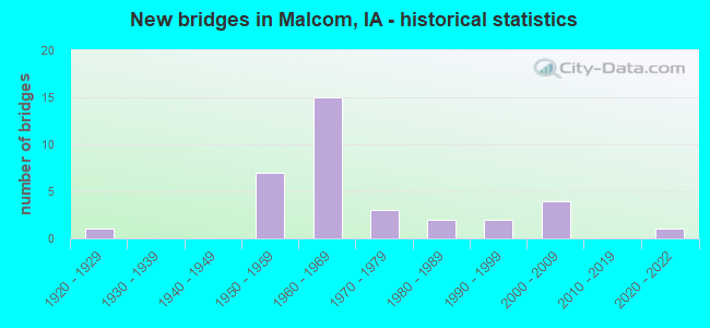
- New bridges - historical statistics
- 11920-1929
- 71950-1959
- 151960-1969
- 31970-1979
- 21980-1989
- 21990-1999
- 42000-2009
- 12020-2022

- Reconstructed bridges - Historical Statistics
- 11960-1969
- 11970-1979
- 11980-1989
- 11990-1999
- 12000-2009


- Bridge Condition - Deck
- 3.6%Excellent
- 10.7%Very good
- 17.9%Good
- 21.4%Satisfactory
- 35.7%Fair
- 3.6%Poor
- 7.1%Serious

- Bridge Condition - Superstructure
- 3.6%Excellent
- 17.9%Very good
- 10.7%Good
- 32.1%Satisfactory
- 21.4%Fair
- 7.1%Poor
- 7.1%Serious

- Bridge Condition - Substructure
- 3.6%Excellent
- 10.7%Very good
- 25.0%Good
- 17.9%Satisfactory
- 14.3%Fair
- 25.0%Poor
- 3.6%Serious

- Bridge Condition - Channel
- 7.4%Very good
- 33.3%Good
- 55.6%Satisfactory
- 3.7%Fair

- Bridge Condition - Culverts
- 33.3%Good
- 66.7%Satisfactory
Find on map >> Show street view
Structure Number: 655, Location: Bettendorf, IA (Lat: 41.598986, Lng: -90.458894), Route carried "on" structure: City street , Year Built: 1964, Status: Open, Structure Length: 1.16m (3.81ft), Average Daily Traffic: 2,550 (year 2018), Average Future Daily Traffic: 2,550 (year 2041), Design Load: H 20, Features Intersected: SPENCER CREEK, Facility Carried by Structure: MIDDLE RD
Minimum Vertical Clearance: 30+ m (98+ ft), Kilometerpoint: 9.724, Lanes on structure: 2, Owner: City or Municipal Highway Agency, Approaching Roadway Width: 15.9m (52.2ft), Material/Design: Concrete continuous, Design/Construction: Culvert, Number Of Spans In Main Unit: 3, Length of Maximum Span: 3.7m (12.1ft)
Condition: Channel: Satisfactory, Culverts: Satisfactory, Operating Rating: 30.8 metric tons, Method Used To Determine Operating Rating: Load Factor (LF), Inventory Rating: 22.7 metric tons, Method Used To Determine Inventory Rating: Load Factor (LF), Structural Evaluation: Equal to present minimum criteria, Waterway Adequacy: Superior to present desirable criteria, Approach Roadway Alignment: Equal to present desirable criteria, Designated Inspection Frequency: Every 24 months, Inspection Date: July 2021
Find on map >> Show street view
Structure Number: 659, Location: Bettendorf, IA (Lat: 41.578833, Lng: -90.492939), Route carried "on" structure: City street , Year Built: 1992, Status: Open, Structure Length: 2.15m (7.05ft), Average Daily Traffic: 370 (year 2002), Average Future Daily Traffic: 370 (year 2041), Design Load: HS 20, Features Intersected: CROW CREEK, Facility Carried by Structure: FIELD SIKE DR
Minimum Vertical Clearance: 30+ m (98+ ft), Kilometerpoint: 0.093, Lanes on structure: 2, Owner: City or Municipal Highway Agency, Approaching Roadway Width: 8.5m (27.9ft), Material/Design: Prestressed concrete, Design/Construction: Stringer/Multi-beam, Number Of Spans In Main Unit: 1, Length of Maximum Span: 20.6m (67.6ft), Curb-To-Curb Width: 9.1m (29.9ft), Out-to-Out Width: 10.1m (33.1ft)
Condition: Deck: Good, Superstructure: Very good, Substructure: Very good, Channel: Good, Operating Rating: 50.8 metric tons, Method Used To Determine Operating Rating: Load Factor (LF), Inventory Rating: 30.5 metric tons, Method Used To Determine Inventory Rating: Load Factor (LF), Structural Evaluation: Better than present minimum criteria, Deck Geometry: Equal to present minimum criteria, Waterway Adequacy: Equal to present minimum criteria, Approach Roadway Alignment: Equal to present minimum criteria, Designated Inspection Frequency: Every 24 months, Inspection Date: July 2021, Deck Structure Type: Concrete Cast-file-Place, Wearing Surface/Protective System: Wearing Surface: Monolithic Concrete
Find on map >> Show street view
Structure Number: 66, Location: Bettendorf, IA (Lat: 41.543294, Lng: -90.511364), Route carried "on" structure: City street , Year Built: 1961, Year Reconstructed: 1975, Status: Posted for load, Structure Length: 3.90m (12.80ft), Average Daily Traffic: 21,200 (year 2014), Average Future Daily Traffic: 21,200 (year 2041), Design Load: H 20, Features Intersected: DUCK CREEK, Facility Carried by Structure: MIDDLE RD
Minimum Vertical Clearance: 30+ m (98+ ft), Kilometerpoint: 1.130, Lanes on structure: 4, Owner: City or Municipal Highway Agency, Approaching Roadway Width: 14.6m (47.9ft), Material/Design: Concrete continuous, Design/Construction: Slab, Number Of Spans In Main Unit: 3, Length of Maximum Span: 14.9m (48.9ft), Curb or Sidewalk Widths: Left: 1.5m (4.9ft), Right: 1.5m (4.9ft), Curb-To-Curb Width: 16.5m (54.1ft), Out-to-Out Width: 20.7m (67.9ft)
Condition: Deck: Fair, Superstructure: Fair, Substructure: Satisfactory, Channel: Good, Operating Rating: 31.9 metric tons, Method Used To Determine Operating Rating: Load Factor (LF), Inventory Rating: 19.1 metric tons, Method Used To Determine Inventory Rating: Load Factor (LF), Structural Evaluation: Meets minimum limits, Deck Geometry: Meets minimum limits, Waterway Adequacy: Better than present minimum criteria, Approach Roadway Alignment: Equal to present desirable criteria, Bridge Posting: Required (Relationship of Operating Rating to Maximum Legal Load: 0.1 - 9.9% below), Length Of Structure Improvement: 12.50m (41.01ft), Designated Inspection Frequency: Every 24 months, Inspection Date: July 2021, Bridge Improvement Cost: $78,000, Roadway Improvement Cost: $10,000, Deck Structure Type: Concrete Cast-file-Place, Wearing Surface/Protective System: Wearing Surface: Monolithic Concrete
Find on map >> Show street view
Structure Number: 653, Location: 000000000 (Lat: 41.651661, Lng: -91.504881), Route carried "on" structure: City street , Year Built: 1957, Status: Open, Structure Length: 0.67m (2.20ft), Average Daily Traffic: 361 (year 1975), Average Future Daily Traffic: 361 (year 2041), Design Load: HS 20, Features Intersected: SO BR RALSTON CREEK, Facility Carried by Structure: THIRD AVE
Minimum Vertical Clearance: 30+ m (98+ ft), Kilometerpoint: 0.592, Lanes on structure: 2, Owner: City or Municipal Highway Agency, Approaching Roadway Width: 9.1m (29.9ft), Material/Design: Concrete, Design/Construction: Frame, Number Of Spans In Main Unit: 1, Length of Maximum Span: 6.1m (20.0ft), Curb or Sidewalk Widths: Left: 1.8m (5.9ft), Right: 1.8m (5.9ft), Curb-To-Curb Width: 9.1m (29.9ft), Out-to-Out Width: 12.8m (42.0ft)
Condition: Deck: Serious, Superstructure: Serious, Substructure: Fair, Channel: Satisfactory, Operating Rating: 33.7 metric tons, Method Used To Determine Operating Rating: Field evaluation and documented engineering judgment, Inventory Rating: 26.1 metric tons, Method Used To Determine Inventory Rating: Field evaluation and documented engineering judgment, Structural Evaluation: High priority of corrective action, Deck Geometry: Equal to present minimum criteria, Waterway Adequacy: Somewhat better than minimum adequacy, Approach Roadway Alignment: Equal to present minimum criteria, Length Of Structure Improvement: 4.50m (14.76ft), Designated Inspection Frequency: Every 24 months, Inspection Date: June 2021, Bridge Improvement Cost: $230,000, Roadway Improvement Cost: $23,000, Deck Structure Type: Concrete Cast-file-Place, Wearing Surface/Protective System: Wearing Surface: Monolithic Concrete
Find on map >> Show street view
Structure Number: 654, Location: 000000000 (Lat: 41.651650, Lng: -91.503433), Route carried "on" structure: City street , Year Built: 1969, Status: Posted for load, Structure Length: 0.76m (2.49ft), Average Daily Traffic: 167 (year 1975), Average Future Daily Traffic: 167 (year 2041), Design Load: H 20, Features Intersected: SO BR RALSTON CREEK, Facility Carried by Structure: SECOND AVE
Minimum Vertical Clearance: 30+ m (98+ ft), Kilometerpoint: 0.681, Lanes on structure: 2, Owner: City or Municipal Highway Agency, Approaching Roadway Width: 7.3m (24.0ft), Material/Design: Concrete, Design/Construction: Channel Beam, Number Of Spans In Main Unit: 1, Length of Maximum Span: 7.3m (24.0ft), Curb or Sidewalk Widths: Left: 1.5m (4.9ft), Right: 1.5m (4.9ft), Curb-To-Curb Width: 7.3m (24.0ft), Out-to-Out Width: 11.0m (36.1ft)
Condition: Deck: Serious, Superstructure: Serious, Substructure: Fair, Channel: Satisfactory, Operating Rating: 21.2 metric tons, Method Used To Determine Operating Rating: Field evaluation and documented engineering judgment, Inventory Rating: 11.1 metric tons, Method Used To Determine Inventory Rating: Field evaluation and documented engineering judgment, Structural Evaluation: High priority of corrective action, Deck Geometry: Somewhat better than minimum adequacy, Waterway Adequacy: Better than present minimum criteria, Approach Roadway Alignment: Equal to present minimum criteria, Bridge Posting: Required (Relationship of Operating Rating to Maximum Legal Load: 30.0 - 39.9% below), Length Of Structure Improvement: 5.00m (16.40ft), Designated Inspection Frequency: Every 12 months, Inspection Date: June 2021, Bridge Improvement Cost: $250,000, Roadway Improvement Cost: $26,000, Deck Structure Type: Concrete Cast-file-Place, Wearing Surface/Protective System: Wearing Surface: Monolithic Concrete
Find on map >> Show street view
Structure Number: 751, Location: 080152701 (Lat: 41.703647, Lng: -92.558981), Route carried "on" structure: City street , Year Built: 1960, Status: Open, Structure Length: 3.72m (12.20ft), Average Daily Traffic: 140 (year 2018), Average Future Daily Traffic: 140 (year 2041), Design Load: H 20, Features Intersected: LITTLE BEAR CREEK, Facility Carried by Structure: WEBSTER ST
Minimum Vertical Clearance: 30+ m (98+ ft), Kilometerpoint: 0.443, Lanes on structure: 2, Owner: County Highway Agency, Approaching Roadway Width: 9.8m (32.2ft), Skew: 2 degrees, Material/Design: Concrete continuous, Design/Construction: Slab, Number Of Spans In Main Unit: 3, Length of Maximum Span: 14.0m (45.9ft), Curb or Sidewalk Widths: Left: 0.3m (1.0ft), Right: 0.3m (1.0ft), Curb-To-Curb Width: 8.5m (27.9ft), Out-to-Out Width: 9.2m (30.2ft)
Condition: Deck: Fair, Superstructure: Fair, Substructure: Satisfactory, Channel: Satisfactory, Operating Rating: 53.3 metric tons, Method Used To Determine Operating Rating: Load Factor (LF), Inventory Rating: 32.0 metric tons, Method Used To Determine Inventory Rating: Load Factor (LF), Structural Evaluation: Somewhat better than minimum adequacy, Deck Geometry: Equal to present minimum criteria, Waterway Adequacy: Better than present minimum criteria, Approach Roadway Alignment: Equal to present desirable criteria, Length Of Structure Improvement: 12.20m (40.03ft), Designated Inspection Frequency: Every 24 months, Inspection Date: December 2021, Bridge Improvement Cost: $311,000, Roadway Improvement Cost: $31,000, Deck Structure Type: Concrete Cast-file-Place, Wearing Surface/Protective System: Wearing Surface: Monolithic Concrete
Find on map >> Show street view
Structure Number: 858, Location: 095120700 (Lat: 43.058442, Lng: -92.309203), Route carried "on" structure: City street , Year Built: 1920, Year Reconstructed: 1973, Status: Open, Structure Length: 0.70m (2.30ft), Average Daily Traffic: 434 (year 1998), Average Future Daily Traffic: 434 (year 2041), Features Intersected: SMALL STREAM, Facility Carried by Structure: E SPRING ST
Minimum Vertical Clearance: 30+ m (98+ ft), Kilometerpoint: 0.301, Lanes on structure: 2, Owner: City or Municipal Highway Agency, Approaching Roadway Width: 10.4m (34.1ft), Material/Design: Concrete, Design/Construction: Slab, Number Of Spans In Main Unit: 1, Length of Maximum Span: 6.1m (20.0ft), Curb or Sidewalk Widths: Left: 1.5m (4.9ft), Right: 1.5m (4.9ft), Curb-To-Curb Width: 10.5m (34.4ft), Out-to-Out Width: 14.0m (45.9ft)
Condition: Deck: Poor, Superstructure: Poor, Substructure: Poor, Channel: Good, Operating Rating: 48.8 metric tons, Method Used To Determine Operating Rating: Allowable Stress (AS), Inventory Rating: 29.2 metric tons, Method Used To Determine Inventory Rating: Allowable Stress (AS), Structural Evaluation: Meets minimum limits, Deck Geometry: Equal to present minimum criteria, Waterway Adequacy: Better than present minimum criteria, Approach Roadway Alignment: Better than present minimum criteria, Length Of Structure Improvement: 2.30m (7.55ft), Designated Inspection Frequency: Every 24 months, Inspection Date: April 2021, Bridge Improvement Cost: $15,000, Roadway Improvement Cost: $2,000, Deck Structure Type: Concrete Cast-file-Place, Wearing Surface/Protective System: Wearing Surface: Bituminous
Find on map >> Show street view
Structure Number: 45801, Location: 3.3 MI. S OF JCT. I-80 (Lat: 41.648989, Lng: -92.552086), Route carried "on" structure: US 63, Year Built: 1985, Status: Open, Structure Length: 4.05m (13.29ft), Average Daily Traffic: 2,830 (year 2020), Truck Traffic: 17%, Average Future Daily Traffic: 2,830 (year 2040), Design Load: HS 20, Features Intersected: NORTH ENGLISH RIVER
Minimum Vertical Clearance: 30+ m (98+ ft), Kilometerpoint: 153.465, Lanes on structure: 2, Base Highway Network: Yes, Owner: State Highway Agency, Approaching Roadway Width: 11.6m (38.1ft), Material/Design: Concrete continuous, Design/Construction: Slab, Number Of Spans In Main Unit: 3, Length of Maximum Span: 15.5m (50.9ft), Curb-To-Curb Width: 12.2m (40.0ft), Out-to-Out Width: 13.2m (43.3ft)
Condition: Deck: Satisfactory, Superstructure: Satisfactory, Substructure: Good, Channel: Satisfactory, Operating Rating: 87.1 metric tons, Method Used To Determine Operating Rating: Load Factor (LF), Inventory Rating: 51.7 metric tons, Method Used To Determine Inventory Rating: Load Factor (LF), Structural Evaluation: Equal to present minimum criteria, Deck Geometry: Equal to present minimum criteria, Waterway Adequacy: Equal to present desirable criteria, Approach Roadway Alignment: Equal to present desirable criteria, Designated Inspection Frequency: Every 24 months, Inspection Date: June 2020, Deck Structure Type: Concrete Cast-file-Place, Wearing Surface/Protective System: Wearing Surface: Monolithic Concrete, Deck Protection: Epoxy Coated Reinforcing
Find on map >> Show street view
Structure Number: 45831, Location: 0.2 MILES NORTH OF I 80 (Lat: 41.702175, Lng: -92.552164), Route carried "on" structure: US 63, Year Built: 1993, Status: Open, Structure Length: 4.05m (13.29ft), Average Daily Traffic: 2,020 (year 2020), Truck Traffic: 26%, Average Future Daily Traffic: 2,020 (year 2040), Design Load: HS 20, Features Intersected: LITTLE BEAR CREEK
Minimum Vertical Clearance: 30+ m (98+ ft), Kilometerpoint: 159.372, Lanes on structure: 2, Base Highway Network: Yes, Owner: State Highway Agency, Approaching Roadway Width: 13.4m (44.0ft), Material/Design: Concrete continuous, Design/Construction: Slab, Number Of Spans In Main Unit: 3, Length of Maximum Span: 15.5m (50.9ft), Curb-To-Curb Width: 12.2m (40.0ft), Out-to-Out Width: 13.2m (43.3ft)
Condition: Deck: Good, Superstructure: Good, Substructure: Satisfactory, Channel: Satisfactory, Operating Rating: 56.5 metric tons, Method Used To Determine Operating Rating: Load Factor (LF), Inventory Rating: 33.8 metric tons, Method Used To Determine Inventory Rating: Load Factor (LF), Structural Evaluation: Equal to present minimum criteria, Deck Geometry: Equal to present minimum criteria, Waterway Adequacy: Equal to present desirable criteria, Approach Roadway Alignment: Equal to present desirable criteria, Designated Inspection Frequency: Every 24 months, Inspection Date: May 2020, Deck Structure Type: Concrete Cast-file-Place, Wearing Surface/Protective System: Wearing Surface: Monolithic Concrete, Deck Protection: Epoxy Coated Reinforcing
Find on map >> Show street view
Structure Number: 45851, Location: 1.0 MILES N OF W JCT US 6 (Lat: 41.760353, Lng: -92.591289), Route carried "on" structure: US 63, Year Built: 1978, Status: Open, Structure Length: 4.45m (14.60ft), Average Daily Traffic: 1,940 (year 2020), Truck Traffic: 24%, Average Future Daily Traffic: 1,940 (year 2040), Design Load: HS 20, Features Intersected: BIG BEAR CREEK
Minimum Vertical Clearance: 30+ m (98+ ft), Kilometerpoint: 169.163, Lanes on structure: 2, Base Highway Network: Yes, Owner: State Highway Agency, Approaching Roadway Width: 13.4m (44.0ft), Skew: 1 degrees, Material/Design: Prestressed concrete, Design/Construction: Stringer/Multi-beam, Number Of Spans In Main Unit: 3, Length of Maximum Span: 18.9m (62.0ft), Curb-To-Curb Width: 13.4m (44.0ft), Out-to-Out Width: 14.4m (47.2ft)
Condition: Deck: Good, Superstructure: Very good, Substructure: Good, Channel: Satisfactory, Operating Rating: 90.5 metric tons, Method Used To Determine Operating Rating: Load Factor (LF), Inventory Rating: 55.1 metric tons, Method Used To Determine Inventory Rating: Load Factor (LF), Structural Evaluation: Better than present minimum criteria, Deck Geometry: Equal to present desirable criteria, Waterway Adequacy: Equal to present desirable criteria, Approach Roadway Alignment: Better than present minimum criteria, Designated Inspection Frequency: Every 24 months, Inspection Date: June 2020, Deck Structure Type: Concrete Cast-file-Place, Wearing Surface/Protective System: Wearing Surface: Monolithic Concrete, Deck Protection: Epoxy Coated Reinforcing
Find on map >> Show street view
Structure Number: 4614, Location: 2.0 mi. W of Jct. U.S. 63 (Lat: 41.695506, Lng: -92.590800), Route carried "on" structure: County highway , Year Built: 1963, Status: Open, Structure Length: 6.55m (21.49ft), Average Daily Traffic: 60 (year 2018), Truck Traffic: 30%, Average Future Daily Traffic: 60 (year 2041), Design Load: H 15, Features Intersected: I-80, Facility Carried by Structure: T60 100TH ST
Minimum Vertical Clearance: 30+ m (98+ ft), Kilometerpoint: 18.039, Lanes on structure: 2, Lanes under structure: 4, Owner: State Highway Agency, Approaching Roadway Width: 7.9m (25.9ft), Material/Design: Prestressed concrete, Design/Construction: Stringer/Multi-beam, Number Of Spans In Main Unit: 4, Length of Maximum Span: 19.8m (65.0ft), Curb or Sidewalk Widths: Left: 0.3m (1.0ft), Right: 0.3m (1.0ft), Curb-To-Curb Width: 7.3m (24.0ft), Out-to-Out Width: 8.7m (28.5ft)
Condition: Deck: Good, Superstructure: Satisfactory, Substructure: Good, Operating Rating: 53.6 metric tons, Method Used To Determine Operating Rating: Load Factor (LF), Inventory Rating: 20.4 metric tons, Method Used To Determine Inventory Rating: Load Factor (LF), Structural Evaluation: Somewhat better than minimum adequacy, Deck Geometry: Equal to present minimum criteria, Underclear: Meets minimum limits, Approach Roadway Alignment: Better than present minimum criteria, Designated Inspection Frequency: Every 24 months, Inspection Date: June 2021, Deck Structure Type: Concrete Cast-file-Place, Wearing Surface/Protective System: Wearing Surface: Monolithic Concrete
Find on map >> Show street view
Structure Number: 4615, Location: AT JCT. US 63 (Lat: 41.696419, Lng: -92.552719), Route carried "on" structure: Interstate 80, Year Built: 1964, Year Reconstructed: 1993, Status: Open, Structure Length: 6.92m (22.70ft), Average Daily Traffic: 11,600 (year 2020), Truck Traffic: 32%, Average Future Daily Traffic: 11,600 (year 2041), Design Load: HS 20, Features Intersected: US 63
Minimum Vertical Clearance: 30+ m (98+ ft), Kilometerpoint: 307.901, Lanes on structure: 2, Lanes under structure: 4, Base Highway Network: Yes, Owner: State Highway Agency, Approaching Roadway Width: 12.2m (40.0ft), Material/Design: Prestressed concrete, Design/Construction: Stringer/Multi-beam, Number Of Spans In Main Unit: 4, Length of Maximum Span: 19.8m (65.0ft), Curb-To-Curb Width: 12.2m (40.0ft), Out-to-Out Width: 13.2m (43.3ft)
Condition: Deck: Fair, Superstructure: Fair, Substructure: Good, Operating Rating: 79.2 metric tons, Method Used To Determine Operating Rating: Load Factor (LF), Inventory Rating: 33.7 metric tons, Method Used To Determine Inventory Rating: Load Factor (LF), Structural Evaluation: Somewhat better than minimum adequacy, Deck Geometry: Better than present minimum criteria, Underclear: Meets minimum limits, Approach Roadway Alignment: Better than present minimum criteria, Designated Inspection Frequency: Every 24 months, Inspection Date: June 2021, Deck Structure Type: Concrete Cast-file-Place, Wearing Surface/Protective System: Wearing Surface: Low Slump Concrete
Find on map >> Show street view
Structure Number: 4616, Location: AT JCT. US 63 (Lat: 41.696617, Lng: -92.551883), Route carried "on" structure: Interstate 80, Year Built: 1964, Status: Open, Structure Length: 6.92m (22.70ft), Average Daily Traffic: 11,600 (year 2020), Truck Traffic: 32%, Average Future Daily Traffic: 11,600 (year 2041), Design Load: HS 20, Features Intersected: US 63
Minimum Vertical Clearance: 30+ m (98+ ft), Kilometerpoint: 185.163, Lanes on structure: 2, Lanes under structure: 4, Owner: State Highway Agency, Approaching Roadway Width: 12.2m (40.0ft), Material/Design: Prestressed concrete, Design/Construction: Stringer/Multi-beam, Number Of Spans In Main Unit: 4, Length of Maximum Span: 19.8m (65.0ft), Curb-To-Curb Width: 9.1m (29.9ft), Out-to-Out Width: 11.0m (36.1ft)
Condition: Deck: Fair, Superstructure: Satisfactory, Substructure: Satisfactory, Operating Rating: 73.8 metric tons, Method Used To Determine Operating Rating: Load Factor (LF), Inventory Rating: 30.2 metric tons, Method Used To Determine Inventory Rating: Load Factor (LF), Structural Evaluation: Equal to present minimum criteria, Deck Geometry: Meets minimum limits, Underclear: Meets minimum limits, Approach Roadway Alignment: Better than present minimum criteria, Designated Inspection Frequency: Every 24 months, Inspection Date: June 2021, Deck Structure Type: Concrete Cast-file-Place, Wearing Surface/Protective System: Wearing Surface: Low Slump Concrete
Find on map >> Show street view
Structure Number: 4617, Location: 2.5 MI EAST OF JCT US 63 (Lat: 41.694294, Lng: -92.503394), Route carried "on" structure: County highway , Year Built: 1963, Status: Open, Structure Length: 6.74m (22.11ft), Average Daily Traffic: 30 (year 2018), Average Future Daily Traffic: 30 (year 2041), Design Load: H 15, Features Intersected: I-80, Facility Carried by Structure: 145TH ST
Minimum Vertical Clearance: 30+ m (98+ ft), Kilometerpoint: 9.727, Lanes on structure: 2, Lanes under structure: 4, Owner: State Highway Agency, Approaching Roadway Width: 7.9m (25.9ft), Material/Design: Prestressed concrete, Design/Construction: Stringer/Multi-beam, Number Of Spans In Main Unit: 4, Length of Maximum Span: 19.8m (65.0ft), Curb-To-Curb Width: 7.3m (24.0ft), Out-to-Out Width: 8.6m (28.2ft)
Condition: Deck: Good, Superstructure: Good, Substructure: Good, Operating Rating: 51.3 metric tons, Method Used To Determine Operating Rating: Load Factor (LF), Inventory Rating: 18.1 metric tons, Method Used To Determine Inventory Rating: Load Factor (LF), Structural Evaluation: Somewhat better than minimum adequacy, Deck Geometry: Equal to present minimum criteria, Underclear: Somewhat better than minimum adequacy, Approach Roadway Alignment: Better than present minimum criteria, Designated Inspection Frequency: Every 24 months, Inspection Date: June 2021, Deck Structure Type: Concrete Cast-file-Place, Wearing Surface/Protective System: Wearing Surface: Monolithic Concrete
Find on map >> Show street view
Structure Number: 888, Location: 092172202 (Lat: 42.768181, Lng: -92.849406), Route carried "on" structure: County highway , Year Built: 1952, Status: Posted for load, Structure Length: 0.94m (3.08ft), Average Daily Traffic: 35 (year 2013), Average Future Daily Traffic: 35 (year 2040), Design Load: H 15, Features Intersected: SMALL STREAM, Facility Carried by Structure: LOCAL
Minimum Vertical Clearance: 30+ m (98+ ft), Kilometerpoint: 19.463, Lanes on structure: 2, Owner: County Highway Agency, Approaching Roadway Width: 7.3m (24.0ft), Material/Design: Concrete, Design/Construction: Slab, Number Of Spans In Main Unit: 1, Length of Maximum Span: 9.1m (29.9ft), Curb-To-Curb Width: 6.1m (20.0ft), Out-to-Out Width: 6.8m (22.3ft)
Condition: Deck: Satisfactory, Superstructure: Satisfactory, Substructure: Poor, Channel: Satisfactory, Operating Rating: 25.5 metric tons, Method Used To Determine Operating Rating: Allowable Stress (AS), Inventory Rating: 17.2 metric tons, Method Used To Determine Inventory Rating: Allowable Stress (AS), Structural Evaluation: Meets minimum limits, Deck Geometry: Somewhat better than minimum adequacy, Waterway Adequacy: Better than present minimum criteria, Approach Roadway Alignment: Equal to present minimum criteria, Bridge Posting: Required (Relationship of Operating Rating to Maximum Legal Load: 10.0 - 19.9% below), Length Of Structure Improvement: 3.10m (10.17ft), Designated Inspection Frequency: Every 24 months, Inspection Date: April 2020, Bridge Improvement Cost: $15,000, Roadway Improvement Cost: $2,000, Deck Structure Type: Concrete Cast-file-Place, Wearing Surface/Protective System: Wearing Surface: Monolithic Concrete
Find on map >> Show street view
Structure Number: 1092, Location: 092413501 (Lat: 42.749903, Lng: -95.650103), Route carried "on" structure: County highway , Year Built: 1968, Status: Open, Structure Length: 0.76m (2.49ft), Average Daily Traffic: 940 (year 2019), Truck Traffic: 13%, Average Future Daily Traffic: 940 (year 2041), Design Load: H 20, Features Intersected: ROCK CREEK, Facility Carried by Structure: FM-530TH ST.
Minimum Vertical Clearance: 30+ m (98+ ft), Kilometerpoint: 17.164, Lanes on structure: 2, Owner: County Highway Agency, Approaching Roadway Width: 12.8m (42.0ft), Material/Design: Concrete continuous, Design/Construction: Culvert, Number Of Spans In Main Unit: 2, Length of Maximum Span: 3.7m (12.1ft)
Condition: Channel: Good, Culverts: Satisfactory, Operating Rating: 38.8 metric tons, Method Used To Determine Operating Rating: Load Factor (LF), Inventory Rating: 23.2 metric tons, Method Used To Determine Inventory Rating: Load Factor (LF), Structural Evaluation: Equal to present minimum criteria, Waterway Adequacy: Better than present minimum criteria, Approach Roadway Alignment: Equal to present desirable criteria, Length Of Structure Improvement: 2.60m (8.53ft), Designated Inspection Frequency: Every 24 months, Inspection Date: August 2021, Bridge Improvement Cost: $15,000, Roadway Improvement Cost: $2,000
Find on map >> Show street view
Structure Number: 29235, Location: 079140702 (Lat: 41.671536, Lng: -92.532828), Route carried "on" structure: County highway , Year Built: 1956, Status: Posted for load, Structure Length: 1.04m (3.41ft), Average Daily Traffic: 10 (year 2018), Average Future Daily Traffic: 10 (year 2041), Features Intersected: STREAM, Facility Carried by Structure: LOCAL
Minimum Vertical Clearance: 30+ m (98+ ft), Kilometerpoint: 2.232, Lanes on structure: 2, Owner: County Highway Agency, Approaching Roadway Width: 7.3m (24.0ft), Material/Design: Steel, Design/Construction: Stringer/Multi-beam, Number Of Spans In Main Unit: 1, Length of Maximum Span: 10.1m (33.1ft), Curb-To-Curb Width: 5.4m (17.7ft), Out-to-Out Width: 5.5m (18.0ft)
Condition: Deck: Fair, Superstructure: Fair, Substructure: Poor, Channel: Satisfactory, Operating Rating: 22.5 metric tons, Method Used To Determine Operating Rating: Allowable Stress (AS), Inventory Rating: 16.7 metric tons, Method Used To Determine Inventory Rating: Allowable Stress (AS), Structural Evaluation: Meets minimum limits, Deck Geometry: High priority of corrective action, Waterway Adequacy: Better than present minimum criteria, Approach Roadway Alignment: Better than present minimum criteria, Bridge Posting: Required (Relationship of Operating Rating to Maximum Legal Load: 10.0 - 19.9% below), Length Of Structure Improvement: 7.00m (22.97ft), Designated Inspection Frequency: Every 24 months, Inspection Date: December 2021, Bridge Improvement Cost: $168,000, Roadway Improvement Cost: $17,000, Deck Structure Type: Wood or Timber, Wearing Surface/Protective System: Wearing Surface: Wood or Timber
Find on map >> Show street view
Structure Number: 292371, Location: 079140804 (Lat: 41.667003, Lng: -92.509072), Route carried "on" structure: County highway , Year Built: 2002, Status: Open, Structure Length: 1.34m (4.40ft), Average Daily Traffic: 30 (year 2018), Average Future Daily Traffic: 30 (year 2039), Design Load: HS 20, Features Intersected: STREAM, Facility Carried by Structure: 142ND ST
Minimum Vertical Clearance: 30+ m (98+ ft), Kilometerpoint: 1.081, Lanes on structure: 2, Owner: County Highway Agency, Approaching Roadway Width: 8.5m (27.9ft), Skew: 3 degrees, Material/Design: Concrete continuous, Design/Construction: Culvert, Number Of Spans In Main Unit: 3, Length of Maximum Span: 4.3m (14.1ft)
Condition: Channel: Good, Culverts: Good, Operating Rating: 44.1 metric tons, Method Used To Determine Operating Rating: Assigned rating based on Load Factor Design (LFD) reported in metric tons, Inventory Rating: 32.7 metric tons, Method Used To Determine Inventory Rating: Assigned rating based on Load Factor Design (LFD) reported in metric tons, Structural Evaluation: Better than present minimum criteria, Waterway Adequacy: Equal to present desirable criteria, Approach Roadway Alignment: Equal to present desirable criteria, Length Of Structure Improvement: 4.40m (14.44ft), Designated Inspection Frequency: Every 48 months, Inspection Date: December 2019, Bridge Improvement Cost: $15,000, Roadway Improvement Cost: $2,000
Find on map >> Show street view
Structure Number: 292631, Location: 079151402 (Lat: 41.647408, Lng: -92.571481), Route carried "on" structure: County highway , Year Built: 2008, Status: Open, Structure Length: 3.35m (10.99ft), Average Daily Traffic: 25 (year 2018), Average Future Daily Traffic: 25 (year 2039), Design Load: HL 93, Features Intersected: N ENGLISH RIVER, Facility Carried by Structure: LOCAL
Minimum Vertical Clearance: 30+ m (98+ ft), Kilometerpoint: 11.043, Lanes on structure: 2, Owner: County Highway Agency, Approaching Roadway Width: 8.5m (27.9ft), Material/Design: Concrete continuous, Design/Construction: Slab, Number Of Spans In Main Unit: 3, Length of Maximum Span: 13.1m (43.0ft), Curb-To-Curb Width: 9.3m (30.5ft), Out-to-Out Width: 10.1m (33.1ft)
Condition: Deck: Very good, Superstructure: Very good, Substructure: Very good, Channel: Very good, Operating Rating: 66.6 metric tons, Method Used To Determine Operating Rating: Load Factor (LF), Inventory Rating: 40.0 metric tons, Method Used To Determine Inventory Rating: Load Factor (LF), Structural Evaluation: Equal to present desirable criteria, Deck Geometry: Better than present minimum criteria, Waterway Adequacy: Equal to present desirable criteria, Approach Roadway Alignment: Equal to present desirable criteria, Designated Inspection Frequency: Every 48 months, Inspection Date: December 2019, Deck Structure Type: Concrete Cast-file-Place, Wearing Surface/Protective System: Wearing Surface: Monolithic Concrete
Find on map >> Show street view
Structure Number: 29264, Location: 079151502 (Lat: 41.651936, Lng: -92.590806), Route carried "on" structure: County highway , Year Built: 1955, Status: Posted for load, Structure Length: 2.87m (9.42ft), Average Daily Traffic: 45 (year 2018), Average Future Daily Traffic: 45 (year 2041), Design Load: H 15, Features Intersected: N ENGLISH RIVER, Facility Carried by Structure: LOCAL
Minimum Vertical Clearance: 30+ m (98+ ft), Kilometerpoint: 13.201, Lanes on structure: 2, Owner: County Highway Agency, Approaching Roadway Width: 7.9m (25.9ft), Material/Design: Prestressed concrete, Design/Construction: Stringer/Multi-beam, Number Of Spans In Main Unit: 3, Length of Maximum Span: 9.4m (30.8ft), Curb or Sidewalk Widths: Left: 0.3m (1.0ft), Right: 0.3m (1.0ft), Curb-To-Curb Width: 6.1m (20.0ft), Out-to-Out Width: 6.7m (22.0ft)
Condition: Deck: Fair, Superstructure: Satisfactory, Substructure: Serious, Channel: Satisfactory, Operating Rating: 3.6 metric tons, Method Used To Determine Operating Rating: Allowable Stress (AS), Structural Evaluation: High priority of replacement, Deck Geometry: Somewhat better than minimum adequacy, Waterway Adequacy: Better than present minimum criteria, Approach Roadway Alignment: Better than present minimum criteria, Bridge Posting: Required (Relationship of Operating Rating to Maximum Legal Load: > 39.9% below), Length Of Structure Improvement: 12.50m (41.01ft), Designated Inspection Frequency: Every 12 months, Inspection Date: December 2021, Bridge Improvement Cost: $270,000, Roadway Improvement Cost: $27,000, Deck Structure Type: Concrete Cast-file-Place, Wearing Surface/Protective System: Wearing Surface: Monolithic Concrete
Find on map >> Show street view
Structure Number: 29342, Location: 080140702 (Lat: 41.753019, Lng: -92.533078), Route carried "on" structure: County highway , Year Built: 1950, Status: Posted for load, Structure Length: 3.69m (12.11ft), Average Daily Traffic: 60 (year 2018), Average Future Daily Traffic: 60 (year 2041), Design Load: H 15, Features Intersected: BEAR CREEK, Facility Carried by Structure: LOCAL
Minimum Vertical Clearance: 30+ m (98+ ft), Kilometerpoint: 5.597, Lanes on structure: 2, Owner: County Highway Agency, Approaching Roadway Width: 8.2m (26.9ft), Material/Design: Steel, Design/Construction: Stringer/Multi-beam, Number Of Spans In Main Unit: 3, Length of Maximum Span: 15.5m (50.9ft), Curb or Sidewalk Widths: Left: 0.3m (1.0ft), Right: 0.3m (1.0ft), Curb-To-Curb Width: 5.4m (17.7ft), Out-to-Out Width: 5.9m (19.4ft)
Condition: Deck: Fair, Superstructure: Satisfactory, Substructure: Poor, Channel: Satisfactory, Operating Rating: 33.3 metric tons, Method Used To Determine Operating Rating: Allowable Stress (AS), Inventory Rating: 18.7 metric tons, Method Used To Determine Inventory Rating: Allowable Stress (AS), Structural Evaluation: Meets minimum limits, Deck Geometry: High priority of corrective action, Waterway Adequacy: Better than present minimum criteria, Approach Roadway Alignment: Better than present minimum criteria, Bridge Posting: Required (Relationship of Operating Rating to Maximum Legal Load: 0.1 - 9.9% below), Length Of Structure Improvement: 15.00m (49.21ft), Designated Inspection Frequency: Every 24 months, Inspection Date: December 2021, Bridge Improvement Cost: $360,000, Roadway Improvement Cost: $36,000, Deck Structure Type: Concrete Cast-file-Place, Wearing Surface/Protective System: Wearing Surface: Monolithic Concrete
Find on map >> Show street view
Structure Number: 29343, Location: 080140703 (Lat: 41.760547, Lng: -92.514294), Route carried "on" structure: County highway , Year Built: 1959, Year Reconstructed: 2008, Status: Open, Structure Length: 0.73m (2.40ft), Average Daily Traffic: 15 (year 2018), Average Future Daily Traffic: 15 (year 2041), Features Intersected: STREAM, Facility Carried by Structure: LOCAL
Minimum Vertical Clearance: 30+ m (98+ ft), Kilometerpoint: 13.902, Lanes on structure: 2, Owner: County Highway Agency, Approaching Roadway Width: 6.7m (22.0ft), Material/Design: Wood or Timber, Design/Construction: Stringer/Multi-beam, Number Of Spans In Main Unit: 1, Length of Maximum Span: 6.7m (22.0ft), Curb-To-Curb Width: 5.4m (17.7ft), Out-to-Out Width: 5.5m (18.0ft)
Condition: Deck: Satisfactory, Superstructure: Good, Substructure: Poor, Channel: Good, Operating Rating: 24.2 metric tons, Method Used To Determine Operating Rating: Allowable Stress (AS), Inventory Rating: 20.1 metric tons, Method Used To Determine Inventory Rating: Allowable Stress (AS), Structural Evaluation: Meets minimum limits, Deck Geometry: High priority of corrective action, Waterway Adequacy: Better than present minimum criteria, Approach Roadway Alignment: Better than present minimum criteria, Length Of Structure Improvement: 5.50m (18.04ft), Designated Inspection Frequency: Every 24 months, Inspection Date: December 2021, Bridge Improvement Cost: $132,000, Roadway Improvement Cost: $13,000, Deck Structure Type: Wood or Timber, Wearing Surface/Protective System: Wearing Surface: Wood or Timber
Find on map >> Show street view
Structure Number: 293581, Location: 080142902 (Lat: 41.705606, Lng: -92.513175), Route carried "on" structure: County highway , Year Built: 2004, Status: Open, Structure Length: 1.52m (4.99ft), Average Daily Traffic: 20 (year 2018), Average Future Daily Traffic: 20 (year 2039), Design Load: HS 20, Features Intersected: LITTLE BEAR CREEK, Facility Carried by Structure: LOCAL
Minimum Vertical Clearance: 30+ m (98+ ft), Kilometerpoint: 6.286, Lanes on structure: 2, Owner: County Highway Agency, Approaching Roadway Width: 6.4m (21.0ft), Material/Design: Steel, Design/Construction: Stringer/Multi-beam, Number Of Spans In Main Unit: 1, Length of Maximum Span: 14.9m (48.9ft), Curb-To-Curb Width: 9.5m (31.2ft), Out-to-Out Width: 9.5m (31.2ft)
Condition: Deck: Very good, Superstructure: Very good, Substructure: Good, Channel: Good, Operating Rating: 54.8 metric tons, Method Used To Determine Operating Rating: Load Factor (LF), Inventory Rating: 32.8 metric tons, Method Used To Determine Inventory Rating: Load Factor (LF), Structural Evaluation: Better than present minimum criteria, Deck Geometry: Better than present minimum criteria, Waterway Adequacy: Meets minimum limits, Approach Roadway Alignment: Equal to present desirable criteria, Length Of Structure Improvement: 5.00m (16.40ft), Designated Inspection Frequency: Every 48 months, Inspection Date: December 2019, Bridge Improvement Cost: $15,000, Roadway Improvement Cost: $2,000, Deck Structure Type: Concrete Cast-file-Place, Wearing Surface/Protective System: Wearing Surface: Monolithic Concrete
Find on map >> Show street view
Structure Number: 2936, Location: 080143004 (Lat: 41.702794, Lng: -92.532903), Route carried "on" structure: County highway , Year Built: 1952, Status: Posted for load, Structure Length: 2.29m (7.51ft), Average Daily Traffic: 20 (year 2018), Average Future Daily Traffic: 20 (year 2041), Design Load: H 15, Features Intersected: LITTLE BEAR CREEK, Facility Carried by Structure: LOCAL
Minimum Vertical Clearance: 30+ m (98+ ft), Kilometerpoint: 2.937, Lanes on structure: 1, Owner: County Highway Agency, Approaching Roadway Width: 6.7m (22.0ft), Material/Design: Steel, Design/Construction: Truss - Thru, Number Of Spans In Main Unit: 1, Length of Maximum Span: 21.3m (69.9ft), Curb-To-Curb Width: 4.8m (15.7ft), Out-to-Out Width: 4.9m (16.1ft)
Condition: Deck: Fair, Superstructure: Poor, Substructure: Poor, Channel: Satisfactory, Operating Rating: 17.2 metric tons, Method Used To Determine Operating Rating: Allowable Stress (AS), Inventory Rating: 12.4 metric tons, Method Used To Determine Inventory Rating: Allowable Stress (AS), Structural Evaluation: Meets minimum limits, Deck Geometry: Equal to present desirable criteria, Waterway Adequacy: Equal to present minimum criteria, Approach Roadway Alignment: Equal to present minimum criteria, Bridge Posting: Required (Relationship of Operating Rating to Maximum Legal Load: 30.0 - 39.9% below), Length Of Structure Improvement: 10.00m (32.81ft), Designated Inspection Frequency: Every 24 months, Critical Feature Inspection Frequency: Every 24 months, Inspection Date: December 2021, Critical Feature Inspection Date: June 2020, Bridge Improvement Cost: $240,000, Roadway Improvement Cost: $24,000, Deck Structure Type: Wood or Timber, Wearing Surface/Protective System: Wearing Surface: Wood or Timber
Find on map >> Show street view
Structure Number: 29362, Location: 080150103 (Lat: 41.763808, Lng: -92.534419), Route carried "on" structure: County highway , Year Built: 1968, Status: Posted for load-capacity, Structure Length: 0.73m (2.40ft), Average Daily Traffic: 10 (year 2018), Average Future Daily Traffic: 10 (year 2041), Features Intersected: STREAM, Facility Carried by Structure: LOCAL
Minimum Vertical Clearance: 30+ m (98+ ft), Kilometerpoint: 12.002, Lanes on structure: 2, Owner: County Highway Agency, Approaching Roadway Width: 6.7m (22.0ft), Skew: 3 degrees, Material/Design: Wood or Timber, Design/Construction: Stringer/Multi-beam, Number Of Spans In Main Unit: 1, Length of Maximum Span: 6.7m (22.0ft), Curb-To-Curb Width: 6.1m (20.0ft), Out-to-Out Width: 6.2m (20.3ft)
Condition: Deck: Fair, Superstructure: Fair, Substructure: Poor, Channel: Satisfactory, Operating Rating: 33.4 metric tons, Method Used To Determine Operating Rating: Allowable Stress (AS), Inventory Rating: 27.0 metric tons, Method Used To Determine Inventory Rating: Allowable Stress (AS), Structural Evaluation: Meets minimum limits, Deck Geometry: Somewhat better than minimum adequacy, Waterway Adequacy: Equal to present minimum criteria, Approach Roadway Alignment: Somewhat better than minimum adequacy, Bridge Posting: Required (Relationship of Operating Rating to Maximum Legal Load: 10.0 - 19.9% below), Length Of Structure Improvement: 2.40m (7.87ft), Designated Inspection Frequency: Every 24 months, Inspection Date: December 2021, Bridge Improvement Cost: $15,000, Roadway Improvement Cost: $2,000, Deck Structure Type: Wood or Timber, Wearing Surface/Protective System: Wearing Surface: Wood or Timber
Find on map >> Show street view
Structure Number: 293631, Location: 080150202 (Lat: 41.761014, Lng: -92.571836), Route carried "on" structure: County highway , Year Built: 1979, Status: Open, Structure Length: 3.14m (10.30ft), Average Daily Traffic: 20 (year 2018), Average Future Daily Traffic: 20 (year 2041), Design Load: HS 20, Features Intersected: BEAR CREEK, Facility Carried by Structure: LOCAL
Minimum Vertical Clearance: 30+ m (98+ ft), Kilometerpoint: 22.843, Lanes on structure: 2, Owner: County Highway Agency, Approaching Roadway Width: 7.6m (24.9ft), Skew: 1 degrees, Material/Design: Concrete continuous, Design/Construction: Slab, Number Of Spans In Main Unit: 3, Length of Maximum Span: 11.9m (39.0ft), Curb or Sidewalk Widths: Left: 0.3m (1.0ft), Right: 0.3m (1.0ft), Curb-To-Curb Width: 9.1m (29.9ft), Out-to-Out Width: 9.8m (32.2ft)
Condition: Deck: Satisfactory, Superstructure: Satisfactory, Substructure: Fair, Channel: Fair, Operating Rating: 49.9 metric tons, Method Used To Determine Operating Rating: Allowable Stress (AS), Inventory Rating: 29.9 metric tons, Method Used To Determine Inventory Rating: Allowable Stress (AS), Structural Evaluation: Somewhat better than minimum adequacy, Deck Geometry: Better than present minimum criteria, Waterway Adequacy: Better than present minimum criteria, Approach Roadway Alignment: Equal to present desirable criteria, Length Of Structure Improvement: 10.30m (33.79ft), Designated Inspection Frequency: Every 24 months, Inspection Date: December 2021, Bridge Improvement Cost: $15,000, Roadway Improvement Cost: $2,000, Deck Structure Type: Concrete Cast-file-Place, Wearing Surface/Protective System: Wearing Surface: Monolithic Concrete
Find on map >> Show street view
Structure Number: 293691, Location: 080151202 (Lat: 41.751553, Lng: -92.552267), Route carried "on" structure: County highway , Year Built: 1969, Year Reconstructed: 2004, Status: Open, Structure Length: 0.76m (2.49ft), Average Daily Traffic: 100 (year 2018), Average Future Daily Traffic: 100 (year 2041), Design Load: H 15, Features Intersected: SMALL STREAM, Facility Carried by Structure: FM
Minimum Vertical Clearance: 30+ m (98+ ft), Kilometerpoint: 0.602, Lanes on structure: 2, Owner: County Highway Agency, Approaching Roadway Width: 7.9m (25.9ft), Material/Design: Concrete, Design/Construction: Channel Beam, Number Of Spans In Main Unit: 1, Length of Maximum Span: 7.3m (24.0ft), Curb or Sidewalk Widths: Left: 0.3m (1.0ft), Right: 0.3m (1.0ft), Curb-To-Curb Width: 7.3m (24.0ft), Out-to-Out Width: 7.8m (25.6ft)
Condition: Deck: Fair, Superstructure: Fair, Substructure: Fair, Channel: Satisfactory, Operating Rating: 43.9 metric tons, Method Used To Determine Operating Rating: Allowable Stress (AS), Inventory Rating: 28.5 metric tons, Method Used To Determine Inventory Rating: Allowable Stress (AS), Structural Evaluation: Somewhat better than minimum adequacy, Deck Geometry: Equal to present minimum criteria, Waterway Adequacy: Equal to present minimum criteria, Approach Roadway Alignment: Equal to present desirable criteria, Length Of Structure Improvement: 2.50m (8.20ft), Designated Inspection Frequency: Every 24 months, Inspection Date: December 2021, Bridge Improvement Cost: $15,000, Roadway Improvement Cost: $2,000, Deck Structure Type: Concrete Precast Panels, Wearing Surface/Protective System: Wearing Surface: Gravel
Find on map >> Show street view
Structure Number: 293701, Location: 080151202 (Lat: 41.756547, Lng: -92.552397), Route carried "on" structure: County highway , Year Built: 1983, Status: Open, Structure Length: 3.87m (12.70ft), Average Daily Traffic: 100 (year 2018), Average Future Daily Traffic: 100 (year 2041), Design Load: H 15, Features Intersected: BIG BEAR CREEK, Facility Carried by Structure: FM
Minimum Vertical Clearance: 30+ m (98+ ft), Kilometerpoint: 1.156, Lanes on structure: 2, Owner: County Highway Agency, Approaching Roadway Width: 8.5m (27.9ft), Skew: 2 degrees, Material/Design: Concrete continuous, Design/Construction: Slab, Number Of Spans In Main Unit: 3, Length of Maximum Span: 14.9m (48.9ft), Curb or Sidewalk Widths: Left: 0.3m (1.0ft), Right: 0.3m (1.0ft), Curb-To-Curb Width: 7.3m (24.0ft), Out-to-Out Width: 8.0m (26.2ft)
Condition: Deck: Satisfactory, Superstructure: Satisfactory, Substructure: Satisfactory, Channel: Good, Operating Rating: 37.2 metric tons, Method Used To Determine Operating Rating: Load Factor (LF), Inventory Rating: 22.3 metric tons, Method Used To Determine Inventory Rating: Load Factor (LF), Structural Evaluation: Equal to present minimum criteria, Deck Geometry: Equal to present minimum criteria, Waterway Adequacy: Equal to present desirable criteria, Approach Roadway Alignment: Equal to present desirable criteria, Length Of Structure Improvement: 12.70m (41.67ft), Designated Inspection Frequency: Every 24 months, Inspection Date: December 2021, Bridge Improvement Cost: $15,000, Roadway Improvement Cost: $2,000, Deck Structure Type: Concrete Cast-file-Place, Wearing Surface/Protective System: Wearing Surface: Monolithic Concrete
Find on map >> Show street view
Structure Number: 293731, Location: 080152104 (Lat: 41.719406, Lng: -92.610078), Route carried "on" structure: County highway , Year Built: 2003, Status: Open, Structure Length: 3.51m (11.52ft), Average Daily Traffic: 30 (year 2018), Truck Traffic: 20%, Average Future Daily Traffic: 30 (year 2039), Design Load: HS 20, Features Intersected: LITTLE BEAR CREEK, Facility Carried by Structure: LOCAL
Minimum Vertical Clearance: 30+ m (98+ ft), Kilometerpoint: 21.694, Lanes on structure: 2, Owner: County Highway Agency, Approaching Roadway Width: 7.3m (24.0ft), Material/Design: Concrete continuous, Design/Construction: Slab, Number Of Spans In Main Unit: 3, Length of Maximum Span: 13.4m (44.0ft), Curb-To-Curb Width: 7.5m (24.6ft), Out-to-Out Width: 8.3m (27.2ft)
Condition: Deck: Very good, Superstructure: Very good, Substructure: Very good, Channel: Good, Operating Rating: 83.3 metric tons, Method Used To Determine Operating Rating: Load Factor (LF), Inventory Rating: 49.8 metric tons, Method Used To Determine Inventory Rating: Load Factor (LF), Structural Evaluation: Equal to present desirable criteria, Deck Geometry: Equal to present minimum criteria, Waterway Adequacy: Equal to present desirable criteria, Approach Roadway Alignment: Equal to present desirable criteria, Length Of Structure Improvement: 11.50m (37.73ft), Designated Inspection Frequency: Every 48 months, Inspection Date: December 2019, Bridge Improvement Cost: $15,000, Roadway Improvement Cost: $2,000, Deck Structure Type: Concrete Cast-file-Place, Wearing Surface/Protective System: Wearing Surface: Monolithic Concrete
Find on map >> Show street view
Structure Number: 293741, Location: 080152604 (Lat: 41.707997, Lng: -92.571414), Route carried "on" structure: County highway , Year Built: 2021, Status: Open, Structure Length: 3.08m (10.10ft), Average Daily Traffic: 25 (year 2018), Average Future Daily Traffic: 25 (year 2041), Design Load: HL 93, Features Intersected: LITTLE BEAR CREEK, Facility Carried by Structure: 110TH ST
Minimum Vertical Clearance: 30+ m (98+ ft), Kilometerpoint: 16.956, Lanes on structure: 2, Owner: County Highway Agency, Approaching Roadway Width: 7.9m (25.9ft), Skew: 1 degrees, Material/Design: Concrete continuous, Design/Construction: Slab, Number Of Spans In Main Unit: 3, Length of Maximum Span: 11.9m (39.0ft), Curb-To-Curb Width: 9.3m (30.5ft), Out-to-Out Width: 10.1m (33.1ft)
Condition: Deck: Excellent, Superstructure: Excellent, Substructure: Excellent, Channel: Very good, Operating Rating: 42.1 metric tons, Method Used To Determine Operating Rating: Assigned ratings based on Load and Resistance Factor Design (LRFD) reported by rating factor (RF) using HL93 loadings, Inventory Rating: 32.4 metric tons, Method Used To Determine Inventory Rating: Assigned ratings based on Load and Resistance Factor Design (LRFD) reported by rating factor (RF) using HL93 loadings, Structural Evaluation: Equal to present desirable criteria, Deck Geometry: Better than present minimum criteria, Waterway Adequacy: Better than present minimum criteria, Approach Roadway Alignment: Equal to present desirable criteria, Designated Inspection Frequency: Every 24 months, Inspection Date: December 2021, Deck Structure Type: Concrete Cast-file-Place, Wearing Surface/Protective System: Wearing Surface: Monolithic Concrete
Find on map >> Show street view
Structure Number: 293761, Location: 080152704 (Lat: 41.713561, Lng: -92.590769), Route carried "on" structure: County highway , Year Built: 1977, Status: Open, Structure Length: 3.14m (10.30ft), Average Daily Traffic: 60 (year 2018), Average Future Daily Traffic: 60 (year 2039), Design Load: HS 20, Features Intersected: LITTLE BEAR CREEK, Facility Carried by Structure: FM
Minimum Vertical Clearance: 30+ m (98+ ft), Kilometerpoint: 20.044, Lanes on structure: 2, Owner: County Highway Agency, Approaching Roadway Width: 8.2m (26.9ft), Material/Design: Prestressed concrete, Design/Construction: Tee Beam, Number Of Spans In Main Unit: 3, Length of Maximum Span: 11.0m (36.1ft), Curb or Sidewalk Widths: Left: 0.3m (1.0ft), Right: 0.3m (1.0ft), Curb-To-Curb Width: 7.8m (25.6ft), Out-to-Out Width: 8.6m (28.2ft)
Condition: Deck: Satisfactory, Superstructure: Satisfactory, Substructure: Good, Channel: Satisfactory, Operating Rating: 80.0 metric tons, Method Used To Determine Operating Rating: Load Factor (LF), Inventory Rating: 46.7 metric tons, Method Used To Determine Inventory Rating: Load Factor (LF), Structural Evaluation: Equal to present minimum criteria, Deck Geometry: Equal to present minimum criteria, Waterway Adequacy: Equal to present desirable criteria, Approach Roadway Alignment: Better than present minimum criteria, Length Of Structure Improvement: 10.30m (33.79ft), Designated Inspection Frequency: Every 48 months, Inspection Date: December 2019, Bridge Improvement Cost: $15,000, Roadway Improvement Cost: $2,000, Deck Structure Type: Concrete Precast Panels, Wearing Surface/Protective System: Wearing Surface: Monolithic Concrete
Find on map >> Show street view
Structure Number: 4614, Location: 2.0 mi. W of Jct. U.S. 63 (Lat: 41.695506, Lng: -92.590800), Route carried "under" structure: Interstate 80, Year Built: 1963, Structure Length: 0. m, Average Daily Traffic: 24,700 (year 2020), Truck Traffic: 31%, Features Intersected: I-80, Facility Carried by Structure: T60 100TH ST
Minimum Vertical Clearance: 30+ m (98+ ft), Kilometerpoint: 304.729, Lanes on structure: 2, Lanes under structure: 4, Material/Design: Prestressed concrete, Design/Construction: Stringer/Multi-beam, Length of Maximum Span: 19.8m (65.0ft)
Find on map >> Show street view
Structure Number: 4615, Location: AT JCT. US 63 (Lat: 41.696419, Lng: -92.552719), Route carried "under" structure: US 63, Year Built: 1964, Structure Length: 0. m, Average Daily Traffic: 1,215 (year 2020), Truck Traffic: 21%, Features Intersected: US 63, Facility Carried by Structure: EB I-80
Minimum Vertical Clearance: 30+ m (98+ ft), Kilometerpoint: 158.728, Lanes on structure: 2, Lanes under structure: 4, Material/Design: Prestressed concrete, Design/Construction: Stringer/Multi-beam, Length of Maximum Span: 19.8m (65.0ft)
Find on map >> Show street view
Structure Number: 4616, Location: AT JCT. US 63 (Lat: 41.696617, Lng: -92.551883), Route carried "under" structure: US 63, Year Built: 1964, Structure Length: 0. m, Average Daily Traffic: 1,215 (year 2020), Truck Traffic: 21%, Features Intersected: US 63, Facility Carried by Structure: WB I 80
Minimum Vertical Clearance: 30+ m (98+ ft), Kilometerpoint: 158.751, Lanes on structure: 2, Lanes under structure: 4, Material/Design: Prestressed concrete, Design/Construction: Stringer/Multi-beam, Length of Maximum Span: 19.8m (65.0ft)
Find on map >> Show street view
Structure Number: 4617, Location: 2.5 MI EAST OF JCT US 63 (Lat: 41.694294, Lng: -92.503394), Route carried "under" structure: Interstate 80, Year Built: 1963, Structure Length: 0. m, Average Daily Traffic: 24,300 (year 2020), Truck Traffic: 32%, Features Intersected: I-80, Facility Carried by Structure: 145TH ST
Minimum Vertical Clearance: 30+ m (98+ ft), Kilometerpoint: 312.007, Lanes on structure: 2, Lanes under structure: 4, Material/Design: Prestressed concrete, Design/Construction: Stringer/Multi-beam, Length of Maximum Span: 19.8m (65.0ft)