Bridge Statistics for Maitland, Pennsylvania (PA)
Condition, Traffic, Stress, Structural Evaluation, Project Costs
- National Bridge Inventory (NBI) Statistics
- 16Number of bridges
- 118ft / 36.1mTotal length
- $1,148,000Total costs
- 40,517Total average daily traffic
- 6,822Total average daily truck traffic
- National Bridge Inventory (NBI) Registered Bridges for Maitland
- No street view available for this location
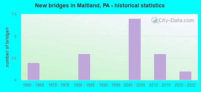
- New bridges - historical statistics
- 21960-1969
- 31980-1989
- 72000-2009
- 32010-2019
- 12020-2022


- Bridge Condition - Deck
- 22.2%Very good
- 66.7%Good
- 11.1%Fair

- Bridge Condition - Superstructure
- 66.7%Very good
- 22.2%Good
- 11.1%Fair

- Bridge Condition - Substructure
- 33.3%Very good
- 33.3%Good
- 11.1%Satisfactory
- 22.2%Fair

- Bridge Condition - Channel
- 33.3%Very good
- 16.7%Good
- 33.3%Satisfactory
- 8.3%Fair
- 8.3%Poor

- Bridge Condition - Culverts
- 50.0%Good
- 25.0%Satisfactory
- 25.0%Fair
Find on map >> Show street view
Structure Number: 2034, Location: 800' SOUTH OF SR 4002 (Lat: 40.557483, Lng: -77.497061), Route carried "on" structure: City street , Year Built: 1985, Year Reconstructed: 2013, Status: Open, Structure Length: 0.94m (3.08ft), Average Daily Traffic: 75 (year 2014), Truck Traffic: 5%, Average Future Daily Traffic: 106 (year 2034), Design Load: HL 93, Features Intersected: EAST LICKING CREEK, Facility Carried by Structure: T-359 FACTORY RD
Minimum Vertical Clearance: 30+ m (98+ ft), Kilometerpoint: 0.000, Lanes on structure: 1, Owner: Town or Township Highway Agency, Approaching Roadway Width: 4.9m (16.1ft), Material/Design: Prestressed concrete, Design/Construction: Slab, Number Of Spans In Main Unit: 1, Length of Maximum Span: 9.1m (29.9ft), Curb or Sidewalk Widths: Left: 0.2m (0.7ft), Right: 0.0m, Curb-To-Curb Width: 4.7m (15.4ft), Out-to-Out Width: 5.9m (19.4ft)
Condition: Deck: Good, Superstructure: Good, Substructure: Fair, Channel: Satisfactory, Operating Rating: 59.6 metric tons, Method Used To Determine Operating Rating: Assigned ratings based on Load and Resistance Factor Design (LRFD) reported by rating factor (RF) using HL93 loadings, Inventory Rating: 39.5 metric tons, Method Used To Determine Inventory Rating: Assigned ratings based on Load and Resistance Factor Design (LRFD) reported by rating factor (RF) using HL93 loadings, Structural Evaluation: Somewhat better than minimum adequacy, Deck Geometry: Better than present minimum criteria, Waterway Adequacy: Equal to present minimum criteria, Approach Roadway Alignment: Somewhat better than minimum adequacy, Length Of Structure Improvement: 1.60m (5.25ft), Designated Inspection Frequency: Every 24 months, Inspection Date: October 2021, Bridge Improvement Cost: $7,000, Roadway Improvement Cost: $21,000, Total Project Cost: $95,000, Deck Structure Type: Concrete Cast-file-Place, Wearing Surface/Protective System: Wearing Surface: Monolithic Concrete, Deck Protection: Epoxy Coated Reinforcing
Find on map >> Show street view
Structure Number: 20341, Location: 1500 FT SE OF SR 4002 (Lat: 40.565669, Lng: -77.475131), Route carried "on" structure: City street , Year Built: 1985, Status: Posted for load, Structure Length: 0.79m (2.59ft), Average Daily Traffic: 50 (year 2014), Truck Traffic: 5%, Average Future Daily Traffic: 63 (year 2034), Design Load: HS 20, Features Intersected: EAST LICKING CREEK, Facility Carried by Structure: T-360 EHRENZELLER
Minimum Vertical Clearance: 30+ m (98+ ft), Kilometerpoint: 0.000, Lanes on structure: 1, Owner: Town or Township Highway Agency, Approaching Roadway Width: 5.5m (18.0ft), Material/Design: Wood or Timber, Design/Construction: Slab, Number Of Spans In Main Unit: 1, Length of Maximum Span: 7.0m (23.0ft), Curb or Sidewalk Widths: Left: 0.2m (0.7ft), Right: 0.2m (0.7ft), Curb-To-Curb Width: 5.3m (17.4ft), Out-to-Out Width: 5.6m (18.4ft)
Condition: Deck: Fair, Superstructure: Fair, Substructure: Fair, Channel: Satisfactory, Operating Rating: 43.5 metric tons, Method Used To Determine Operating Rating: Allowable Stress (AS), Inventory Rating: 30.8 metric tons, Method Used To Determine Inventory Rating: Allowable Stress (AS), Structural Evaluation: Somewhat better than minimum adequacy, Deck Geometry: High priority of corrective action, Waterway Adequacy: Better than present minimum criteria, Approach Roadway Alignment: Equal to present desirable criteria, Bridge Posting: Required (Relationship of Operating Rating to Maximum Legal Load: 0.1 - 9.9% below), Length Of Structure Improvement: 0.90m (2.95ft), Designated Inspection Frequency: Every 24 months, Other Special Inspection Frequency: Every 12 months, Inspection Date: October 2021, Other Special Inspection Date: October 2021, Bridge Improvement Cost: $35,000, Roadway Improvement Cost: $195,000, Total Project Cost: $475,000, Wearing Surface/Protective System: Wearing Surface: Bituminous
Find on map >> Show street view
Structure Number: 2651, Location: MAITLAND (Lat: 40.633431, Lng: -77.506289), Route carried "on" structure: State highway , Year Built: 1987, Status: Open, Structure Length: 0.82m (2.69ft), Average Daily Traffic: 725 (year 2022), Truck Traffic: 8%, Average Future Daily Traffic: 994 (year 2040), Design Load: HS 20+Mod, Features Intersected: BRANCH JACKS CREEK, Facility Carried by Structure: SR 2001
Minimum Vertical Clearance: 30+ m (98+ ft), Kilometerpoint: 0.000, Lanes on structure: 2, Owner: State Highway Agency, Approaching Roadway Width: 6.1m (20.0ft), Skew: 1 degrees, Material/Design: Concrete, Design/Construction: Culvert, Number Of Spans In Main Unit: 2, Length of Maximum Span: 3.7m (12.1ft), Curb-To-Curb Width: 8.0m (26.2ft), Out-to-Out Width: 9.1m (29.9ft)
Condition: Channel: Fair, Culverts: Satisfactory, Operating Rating: 73.5 metric tons, Method Used To Determine Operating Rating: Load Factor (LF), Inventory Rating: 43.5 metric tons, Method Used To Determine Inventory Rating: Load Factor (LF), Structural Evaluation: Equal to present minimum criteria, Deck Geometry: Somewhat better than minimum adequacy, Waterway Adequacy: Equal to present minimum criteria, Approach Roadway Alignment: Equal to present desirable criteria, Length Of Structure Improvement: 0.80m (2.62ft), Designated Inspection Frequency: Every 24 months, Inspection Date: October 2020
Find on map >> Show street view
Structure Number: 26513, Location: 1 MI N MAITLAND (Lat: 40.639700, Lng: -77.512881), Route carried "on" structure: State highway , Year Built: 1961, Status: Open, Structure Length: 0.73m (2.40ft), Average Daily Traffic: 1,210 (year 2022), Truck Traffic: 4%, Average Future Daily Traffic: 1,747 (year 2041), Design Load: HS 20, Features Intersected: BRANCH JACKS CREEK, Facility Carried by Structure: SR 2001
Minimum Vertical Clearance: 30+ m (98+ ft), Kilometerpoint: 1.302, Lanes on structure: 2, Owner: State Highway Agency, Approaching Roadway Width: 7.9m (25.9ft), Skew: 4 degrees, Material/Design: Steel, Design/Construction: Culvert, Number Of Spans In Main Unit: 1, Length of Maximum Span: 7.3m (24.0ft)
Condition: Channel: Poor, Culverts: Fair, Operating Rating: 54.4 metric tons, Method Used To Determine Operating Rating: Field evaluation and documented engineering judgment, Inventory Rating: 32.7 metric tons, Method Used To Determine Inventory Rating: Field evaluation and documented engineering judgment, Structural Evaluation: Somewhat better than minimum adequacy, Waterway Adequacy: Superior to present desirable criteria, Approach Roadway Alignment: Equal to present desirable criteria, Length Of Structure Improvement: 0.70m (2.30ft), Designated Inspection Frequency: Every 24 months, Inspection Date: October 2021, Bridge Improvement Cost: $27,000, Roadway Improvement Cost: $228,000, Total Project Cost: $361,000
Find on map >> Show street view
Structure Number: 26514, Location: 1 MI NW MAITLAND (Lat: 40.642847, Lng: -77.517594), Route carried "on" structure: State highway , Year Built: 1961, Status: Open, Structure Length: 0.85m (2.79ft), Average Daily Traffic: 1,210 (year 2022), Truck Traffic: 4%, Average Future Daily Traffic: 1,747 (year 2041), Design Load: HS 20, Features Intersected: BRANCH JACKS CREEK, Facility Carried by Structure: SR 2001
Minimum Vertical Clearance: 30+ m (98+ ft), Kilometerpoint: 2.129, Lanes on structure: 2, Owner: State Highway Agency, Approaching Roadway Width: 7.9m (25.9ft), Skew: 4 degrees, Material/Design: Concrete, Design/Construction: Slab, Number Of Spans In Main Unit: 1, Length of Maximum Span: 7.9m (25.9ft), Curb or Sidewalk Widths: Left: 0.5m (1.6ft), Right: 0.5m (1.6ft), Curb-To-Curb Width: 9.6m (31.5ft), Out-to-Out Width: 11.1m (36.4ft)
Condition: Deck: Good, Superstructure: Good, Substructure: Satisfactory, Channel: Satisfactory, Operating Rating: 57.2 metric tons, Method Used To Determine Operating Rating: Allowable Stress (AS), Inventory Rating: 34.5 metric tons, Method Used To Determine Inventory Rating: Allowable Stress (AS), Structural Evaluation: Equal to present minimum criteria, Deck Geometry: Somewhat better than minimum adequacy, Waterway Adequacy: Equal to present minimum criteria, Approach Roadway Alignment: Equal to present desirable criteria, Length Of Structure Improvement: 0.90m (2.95ft), Designated Inspection Frequency: Every 24 months, Inspection Date: October 2021, Bridge Improvement Cost: $16,000, Roadway Improvement Cost: $146,000, Total Project Cost: $217,000, Deck Structure Type: Concrete Cast-file-Place, Wearing Surface/Protective System: Wearing Surface: Bituminous
Find on map >> Show street view
Structure Number: 41999, Location: 3 MI WEST OF MIFFLINTOWN (Lat: 40.598064, Lng: -77.497569), Route carried "on" structure: US 22, Year Built: 2003, Status: Open, Structure Length: 3.54m (11.61ft), Average Daily Traffic: 7,591 (year 2020), Truck Traffic: 25%, Average Future Daily Traffic: 9,966 (year 2041), Design Load: HS 25 or greater, Features Intersected: SR 3002 ARCH ROCK ROAD
Minimum Vertical Clearance: 30+ m (98+ ft), Kilometerpoint: 7.115, Lanes on structure: 2, Lanes under structure: 2, Base Highway Network: Yes, Owner: State Highway Agency, Approaching Roadway Width: 12.8m (42.0ft), Skew: 10 degrees, Material/Design: Prestressed concrete, Design/Construction: Box Beam or Girders - Single/Spread, Number Of Spans In Main Unit: 1, Length of Maximum Span: 35.4m (116.1ft), Curb or Sidewalk Widths: Left: 0.1m (0.3ft), Right: 0.1m (0.3ft), Curb-To-Curb Width: 12.8m (42.0ft), Out-to-Out Width: 13.7m (44.9ft)
Condition: Deck: Good, Superstructure: Very good, Substructure: Good, Inventory Rating: 54.4 metric tons, Method Used To Determine Inventory Rating: Load Factor (LF), Structural Evaluation: Better than present minimum criteria, Deck Geometry: Equal to present desirable criteria, Underclear: Meets minimum limits, Approach Roadway Alignment: Equal to present desirable criteria, Length Of Structure Improvement: 4.40m (14.44ft), Designated Inspection Frequency: Every 24 months, Inspection Date: August 2021, Deck Structure Type: Concrete Cast-file-Place, Wearing Surface/Protective System: Wearing Surface: Monolithic Concrete, Deck Protection: Epoxy Coated Reinforcing
Find on map >> Show street view
Structure Number: 43517, Location: 2 MILE NW CUBA MILLS (Lat: 40.611206, Lng: -77.444236), Route carried "on" structure: US 22, Year Built: 2006, Status: Open, Structure Length: 8.99m (29.49ft), Average Daily Traffic: 9,514 (year 2021), Truck Traffic: 23%, Average Future Daily Traffic: 10,916 (year 2040), Design Load: HL 93, Features Intersected: MACEDONIA RUN
Minimum Vertical Clearance: 30+ m (98+ ft), Kilometerpoint: 4.897, Lanes on structure: 2, Lanes under structure: 2, Base Highway Network: Yes, Owner: State Highway Agency, Approaching Roadway Width: 13.1m (43.0ft), Skew: 31 degrees, Material/Design: Prestressed concrete continuous, Design/Construction: Stringer/Multi-beam, Number Of Spans In Main Unit: 2, Length of Maximum Span: 44.2m (145.0ft), Curb or Sidewalk Widths: Left: 0.1m (0.3ft), Right: 0.1m (0.3ft), Curb-To-Curb Width: 13.0m (42.7ft), Out-to-Out Width: 13.8m (45.3ft)
Condition: Deck: Good, Superstructure: Very good, Substructure: Good, Channel: Very good, Operating Rating: 88.0 metric tons, Method Used To Determine Operating Rating: Load Factor (LF), Inventory Rating: 31.8 metric tons, Method Used To Determine Inventory Rating: Load Factor (LF), Structural Evaluation: Better than present minimum criteria, Deck Geometry: Superior to present desirable criteria, Waterway Adequacy: Superior to present desirable criteria, Approach Roadway Alignment: Equal to present desirable criteria, Designated Inspection Frequency: Every 24 months, Inspection Date: April 2020, Deck Structure Type: Concrete Cast-file-Place, Wearing Surface/Protective System: Wearing Surface: Epoxy Overlay, Deck Protection: Epoxy Coated Reinforcing
Find on map >> Show street view
Structure Number: 4411, Location: 1.5 MI. W. ARCH ROCK ENT (Lat: 40.598194, Lng: -77.497292), Route carried "on" structure: US 22, Year Built: 2006, Status: Open, Structure Length: 8.84m (29.00ft), Average Daily Traffic: 9,840 (year 2021), Truck Traffic: 22%, Average Future Daily Traffic: 10,652 (year 2040), Design Load: HL 93, Features Intersected: MACEDONIA RUN
Minimum Vertical Clearance: 30+ m (98+ ft), Kilometerpoint: 4.896, Lanes on structure: 2, Lanes under structure: 1, Base Highway Network: Yes, Owner: State Highway Agency, Approaching Roadway Width: 13.1m (43.0ft), Skew: 31 degrees, Material/Design: Prestressed concrete continuous, Design/Construction: Stringer/Multi-beam, Number Of Spans In Main Unit: 2, Length of Maximum Span: 44.2m (145.0ft), Curb or Sidewalk Widths: Left: 0.1m (0.3ft), Right: 0.1m (0.3ft), Curb-To-Curb Width: 13.0m (42.7ft), Out-to-Out Width: 13.8m (45.3ft)
Condition: Deck: Good, Superstructure: Very good, Substructure: Good, Channel: Very good, Operating Rating: 88.0 metric tons, Method Used To Determine Operating Rating: Load Factor (LF), Inventory Rating: 31.8 metric tons, Method Used To Determine Inventory Rating: Load Factor (LF), Structural Evaluation: Better than present minimum criteria, Deck Geometry: Superior to present desirable criteria, Underclear: Superior to present desirable criteria, Waterway Adequacy: Superior to present desirable criteria, Approach Roadway Alignment: Equal to present desirable criteria, Designated Inspection Frequency: Every 24 months, Inspection Date: April 2020, Deck Structure Type: Concrete Cast-file-Place, Wearing Surface/Protective System: Wearing Surface: Monolithic Concrete, Deck Protection: Epoxy Coated Reinforcing
Find on map >> Show street view
Structure Number: 44383, Location: 1.5 MI NW ARCH ROCK (Lat: 40.610442, Lng: -77.444036), Route carried "on" structure: City street 1009, Year Built: 2008, Status: Open, Structure Length: 1.71m (5.61ft), Average Daily Traffic: 10 (year 2011), Truck Traffic: 1%, Average Future Daily Traffic: 20 (year 2031), Design Load: HS 25 or greater, Features Intersected: MACEDONIA RUN, Facility Carried by Structure: T-533
Minimum Vertical Clearance: 30+ m (98+ ft), Kilometerpoint: 0.000, Lanes on structure: 2, Owner: Town or Township Highway Agency, Approaching Roadway Width: 9.1m (29.9ft), Skew: 1 degrees, Material/Design: Prestressed concrete, Design/Construction: Box Beam or Girders - Single/Spread, Number Of Spans In Main Unit: 1, Length of Maximum Span: 16.5m (54.1ft), Curb or Sidewalk Widths: Left: 0.2m (0.7ft), Right: 0.2m (0.7ft), Curb-To-Curb Width: 9.1m (29.9ft), Out-to-Out Width: 10.4m (34.1ft)
Condition: Deck: Good, Superstructure: Very good, Substructure: Very good, Channel: Very good, Operating Rating: 65.3 metric tons, Method Used To Determine Operating Rating: Load Factor (LF), Inventory Rating: 39.0 metric tons, Method Used To Determine Inventory Rating: Load Factor (LF), Structural Evaluation: Equal to present desirable criteria, Deck Geometry: Better than present minimum criteria, Waterway Adequacy: Better than present minimum criteria, Approach Roadway Alignment: Equal to present desirable criteria, Designated Inspection Frequency: Every 24 months, Inspection Date: October 2021, Deck Structure Type: Concrete Cast-file-Place, Wearing Surface/Protective System: Wearing Surface: Monolithic Concrete, Deck Protection: Epoxy Coated Reinforcing
Find on map >> Show street view
Structure Number: 47432, Location: MAITLAND (Lat: 40.631981, Lng: -77.504931), Route carried "on" structure: State highway , Year Built: 2012, Status: Open, Structure Length: 4.45m (14.60ft), Average Daily Traffic: 725 (year 2022), Truck Traffic: 8%, Average Future Daily Traffic: 994 (year 2040), Design Load: HL 93, Features Intersected: JACKS CREEK, Facility Carried by Structure: SR 2001
Minimum Vertical Clearance: 30+ m (98+ ft), Kilometerpoint: 0.000, Lanes on structure: 2, Owner: State Highway Agency, Approaching Roadway Width: 6.1m (20.0ft), Skew: 3 degrees, Material/Design: Prestressed concrete continuous, Design/Construction: Box Beam or Girders - Single/Spread, Number Of Spans In Main Unit: 2, Length of Maximum Span: 22.3m (73.2ft), Curb or Sidewalk Widths: Left: 0.2m (0.7ft), Right: 0.2m (0.7ft), Curb-To-Curb Width: 7.3m (24.0ft), Out-to-Out Width: 8.4m (27.6ft)
Condition: Deck: Very good, Superstructure: Very good, Substructure: Very good, Channel: Good, Operating Rating: 61.2 metric tons, Method Used To Determine Operating Rating: Assigned ratings based on Load and Resistance Factor Design (LRFD) reported by rating factor (RF) using HL93 loadings, Inventory Rating: 38.6 metric tons, Method Used To Determine Inventory Rating: Assigned ratings based on Load and Resistance Factor Design (LRFD) reported by rating factor (RF) using HL93 loadings, Structural Evaluation: Equal to present desirable criteria, Deck Geometry: Meets minimum limits, Waterway Adequacy: Superior to present desirable criteria, Approach Roadway Alignment: Better than present minimum criteria, Designated Inspection Frequency: Every 24 months, Inspection Date: October 2020, Deck Structure Type: Concrete Cast-file-Place, Wearing Surface/Protective System: Wearing Surface: Monolithic Concrete, Deck Protection: Epoxy Coated Reinforcing
Find on map >> Show street view
Structure Number: 48309, Location: 0.2 MI S SR 4002 (Lat: 40.557197, Lng: -77.496456), Route carried "on" structure: City street , Year Built: 2013, Status: Open, Structure Length: 0.64m (2.10ft), Average Daily Traffic: 75 (year 2014), Truck Traffic: 5%, Average Future Daily Traffic: 106 (year 2034), Design Load: HL 93, Features Intersected: EAST LICKING CREEK, Facility Carried by Structure: T-359 FACTORY RD
Minimum Vertical Clearance: 30+ m (98+ ft), Kilometerpoint: 0.000, Lanes on structure: 1, Owner: Town or Township Highway Agency, Approaching Roadway Width: 4.9m (16.1ft), Material/Design: Concrete, Design/Construction: Culvert, Number Of Spans In Main Unit: 1, Length of Maximum Span: 6.4m (21.0ft), Curb-To-Curb Width: 4.7m (15.4ft), Out-to-Out Width: 5.9m (19.4ft)
Condition: Channel: Good, Culverts: Good, Operating Rating: 53.5 metric tons, Method Used To Determine Operating Rating: Assigned ratings based on Load and Resistance Factor Design (LRFD) reported by rating factor (RF) using HL93 loadings, Inventory Rating: 33.7 metric tons, Method Used To Determine Inventory Rating: Assigned ratings based on Load and Resistance Factor Design (LRFD) reported by rating factor (RF) using HL93 loadings, Structural Evaluation: Better than present minimum criteria, Deck Geometry: Better than present minimum criteria, Waterway Adequacy: Equal to present minimum criteria, Approach Roadway Alignment: Equal to present desirable criteria, Designated Inspection Frequency: Every 24 months, Inspection Date: October 2021, Wearing Surface/Protective System: Wearing Surface: Bituminous, Membrane: Preformed Fabric, Deck Protection: Epoxy Coated Reinforcing
Find on map >> Show street view
Structure Number: 5687, Location: 500 FT N OF SR 2002 (Lat: 40.660861, Lng: -77.519194), Route carried "on" structure: City street , Year Built: 2011, Status: Open, Structure Length: 0.76m (2.49ft), Average Daily Traffic: 100 (year 2021), Truck Traffic: 1%, Average Future Daily Traffic: 100 (year 2041), Design Load: HL 93, Features Intersected: HUNGRY RUN, Facility Carried by Structure: T-433 RIDENS RD
Minimum Vertical Clearance: 30+ m (98+ ft), Kilometerpoint: 0.000, Lanes on structure: 2, Owner: Town or Township Highway Agency, Approaching Roadway Width: 5.8m (19.0ft), Skew: 1 degrees, Material/Design: Concrete, Design/Construction: Culvert, Number Of Spans In Main Unit: 1, Length of Maximum Span: 7.6m (24.9ft), Curb-To-Curb Width: 6.6m (21.7ft), Out-to-Out Width: 7.7m (25.3ft)
Condition: Channel: Satisfactory, Culverts: Good, Operating Rating: 48.6 metric tons, Method Used To Determine Operating Rating: Assigned ratings based on Load and Resistance Factor Design (LRFD) reported by rating factor (RF) using HL93 loadings, Inventory Rating: 32.4 metric tons, Method Used To Determine Inventory Rating: Assigned ratings based on Load and Resistance Factor Design (LRFD) reported by rating factor (RF) using HL93 loadings, Structural Evaluation: Better than present minimum criteria, Deck Geometry: Somewhat better than minimum adequacy, Waterway Adequacy: Equal to present desirable criteria, Approach Roadway Alignment: Equal to present desirable criteria, Designated Inspection Frequency: Every 24 months, Inspection Date: August 2021
Find on map >> Show street view
Structure Number: 67775, Location: 2 MILES NE LEWISTOWN (Lat: 40.613567, Lng: -77.531917), Route carried "on" structure: State highway , Year Built: 2020, Status: Open, Structure Length: 3.05m (10.01ft), Average Daily Traffic: 2,202 (year 2022), Truck Traffic: 3%, Average Future Daily Traffic: 3,000 (year 2040), Design Load: HL 93, Features Intersected: JACKS CREEK, Facility Carried by Structure: SR 2004
Minimum Vertical Clearance: 30+ m (98+ ft), Kilometerpoint: 3.951, Lanes on structure: 2, Owner: State Highway Agency, Approaching Roadway Width: 6.7m (22.0ft), Skew: 3 degrees, Material/Design: Steel, Design/Construction: Stringer/Multi-beam, Number Of Spans In Main Unit: 1, Length of Maximum Span: 30.2m (99.1ft), Curb or Sidewalk Widths: Left: 0.2m (0.7ft), Right: 0.2m (0.7ft), Curb-To-Curb Width: 8.5m (27.9ft), Out-to-Out Width: 9.6m (31.5ft)
Condition: Deck: Very good, Superstructure: Very good, Substructure: Very good, Channel: Very good, Operating Rating: 62.2 metric tons, Method Used To Determine Operating Rating: Assigned ratings based on Load and Resistance Factor Design (LRFD) reported by rating factor (RF) using HL93 loadings, Inventory Rating: 48.0 metric tons, Method Used To Determine Inventory Rating: Assigned ratings based on Load and Resistance Factor Design (LRFD) reported by rating factor (RF) using HL93 loadings, Structural Evaluation: Equal to present desirable criteria, Deck Geometry: Meets minimum limits, Waterway Adequacy: Equal to present desirable criteria, Approach Roadway Alignment: Equal to present desirable criteria, Designated Inspection Frequency: Every 24 months, Inspection Date: November 2020, Deck Structure Type: Concrete Cast-file-Place, Wearing Surface/Protective System: Wearing Surface: Epoxy Overlay, Deck Protection: Epoxy Coated Reinforcing
Find on map >> Show street view
Structure Number: 4167, Location: 3 MI WEST OF MIFFLINTOWN (Lat: 40.597889, Lng: -77.497611), Route carried "under" structure: Alternate State highway , Year Built: 2002, Structure Length: 0. m, Average Daily Traffic: 3,595 (year 2021), Truck Traffic: 4%, Features Intersected: SR 3002 ARCH ROCK ROAD, Facility Carried by Structure: SR 22-US 22
Minimum Vertical Clearance: 5.22m (17.13ft), Kilometerpoint: 0.000, Lanes on structure: 2, Lanes under structure: 2, Material/Design: Prestressed concrete, Design/Construction: Box Beam or Girders - Single/Spread, Length of Maximum Span: 35.1m (115.2ft)
Find on map >> Show street view
Structure Number: 41999, Location: 3 MI WEST OF MIFFLINTOWN (Lat: 40.598064, Lng: -77.497569), Route carried "under" structure: Alternate State highway , Year Built: 2003, Structure Length: 0. m, Average Daily Traffic: 3,595 (year 2021), Truck Traffic: 4%, Features Intersected: SR 3002 ARCH ROCK ROAD, Facility Carried by Structure: SR 22-US 22
Minimum Vertical Clearance: 4.62m (15.16ft), Kilometerpoint: 0.000, Lanes on structure: 2, Lanes under structure: 2, Material/Design: Prestressed concrete, Design/Construction: Box Beam or Girders - Single/Spread, Length of Maximum Span: 35.4m (116.1ft)
Find on map >> Show street view
Structure Number: 43517, Location: 2 MILE NW CUBA MILLS (Lat: 40.611206, Lng: -77.444236), Route carried "under" structure: ServiceOther road , Year Built: 2006, Structure Length: 0. m, Features Intersected: MACEDONIA RUN, Facility Carried by Structure: SR 22-US 22
Minimum Vertical Clearance: 10.31m (33.83ft), Kilometerpoint: 0.000, Lanes on structure: 2, Lanes under structure: 2, Material/Design: Prestressed concrete continuous, Design/Construction: Stringer/Multi-beam, Length of Maximum Span: 44.2m (145.0ft)