Bridge Statistics for Maine, New York (NY)
Condition, Traffic, Stress, Structural Evaluation, Project Costs
- National Bridge Inventory (NBI) Statistics
- 17Number of bridges
- 98ft / 30.4mTotal length
- $17,924,000Total costs
- 38,780Total average daily traffic
- 2,450Total average daily truck traffic
- 47,465Total future (year 2031) average daily traffic
- National Bridge Inventory (NBI) Registered Bridges for Maine
- No street view available for this location
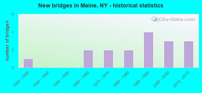
- New bridges - historical statistics
- 11930-1939
- 21960-1969
- 21970-1979
- 21980-1989
- 41990-1999
- 32000-2009
- 32010-2019


- Bridge Condition - Deck
- 40.0%Very good
- 30.0%Good
- 30.0%Fair

- Bridge Condition - Superstructure
- 20.0%Excellent
- 30.0%Very good
- 20.0%Good
- 30.0%Fair

- Bridge Condition - Substructure
- 10.0%Excellent
- 30.0%Very good
- 30.0%Good
- 10.0%Satisfactory
- 10.0%Fair
- 10.0%Poor

- Bridge Condition - Channel
- 23.5%Very good
- 23.5%Good
- 41.2%Satisfactory
- 11.8%Fair

- Bridge Condition - Culverts
- 28.6%Excellent
- 42.9%Very good
- 28.6%Satisfactory
Find on map >> Show street view
Structure Number: 101849, Location: 2.6 MI N JCT RTS 26 + 38B (Lat: 42.190564, Lng: -76.061750), Route carried "on" structure: State highway 26, Year Built: 1961, Status: Open, Structure Length: 0.82m (2.69ft), Average Daily Traffic: 4,934 (year 2017), Truck Traffic: 6%, Average Future Daily Traffic: 5,993 (year 2040), Design Load: HS 20+Mod, Features Intersected: LEWIS CREEK
Minimum Vertical Clearance: 30+ m (98+ ft), Kilometerpoint: 25.245, Lanes on structure: 2, Base Highway Network: Yes, Owner: State Highway Agency, Approaching Roadway Width: 9.8m (32.2ft), Skew: 1 degrees, Material/Design: Concrete, Design/Construction: Slab, Number Of Spans In Main Unit: 1, Length of Maximum Span: 7.9m (25.9ft), Curb-To-Curb Width: 13.0m (42.7ft), Out-to-Out Width: 14.2m (46.6ft)
Condition: Deck: Good, Superstructure: Good, Substructure: Satisfactory, Channel: Satisfactory, Operating Rating: 59.0 metric tons, Method Used To Determine Operating Rating: Load Factor (LF), Inventory Rating: 35.4 metric tons, Method Used To Determine Inventory Rating: Load Factor (LF), Structural Evaluation: Equal to present minimum criteria, Deck Geometry: Equal to present minimum criteria, Waterway Adequacy: Equal to present minimum criteria, Approach Roadway Alignment: Equal to present desirable criteria, Length Of Structure Improvement: 0.82m (2.69ft), Designated Inspection Frequency: Every 24 months, Inspection Date: June 2021, Bridge Improvement Cost: $534,000, Roadway Improvement Cost: $313,000, Total Project Cost: $847,000 ( Estimate for 2021), Wearing Surface/Protective System: Wearing Surface: Bituminous
Find on map >> Show street view
Structure Number: 10185, Location: 3.4 MI N JCT RTS 26 & 38B (Lat: 42.201194, Lng: -76.056708), Route carried "on" structure: State highway 26, Year Built: 1990, Status: Open, Structure Length: 1.98m (6.50ft), Average Daily Traffic: 4,934 (year 2017), Truck Traffic: 6%, Average Future Daily Traffic: 5,993 (year 2040), Design Load: HS 20, Features Intersected: KETCHUMVILLE CRK
Minimum Vertical Clearance: 30+ m (98+ ft), Kilometerpoint: 26.790, Lanes on structure: 2, Base Highway Network: Yes, Owner: State Highway Agency, Approaching Roadway Width: 12.5m (41.0ft), Skew: 2 degrees, Material/Design: Prestressed concrete, Design/Construction: Box Beam or Girders - Multiple, Number Of Spans In Main Unit: 1, Length of Maximum Span: 18.5m (60.7ft), Curb-To-Curb Width: 12.3m (40.4ft), Out-to-Out Width: 13.0m (42.7ft)
Condition: Deck: Fair, Superstructure: Fair, Substructure: Fair, Channel: Good, Operating Rating: 46.7 metric tons, Method Used To Determine Operating Rating: Load and Resistance Factor Rating (LRFR) rating reported by rating factor(RF) method using HL-93 loadings, Inventory Rating: 36.0 metric tons, Method Used To Determine Inventory Rating: Load and Resistance Factor Rating (LRFR) rating reported by rating factor(RF) method using HL-93 loadings, Structural Evaluation: Somewhat better than minimum adequacy, Deck Geometry: Equal to present minimum criteria, Waterway Adequacy: Somewhat better than minimum adequacy, Approach Roadway Alignment: Equal to present desirable criteria, Length Of Structure Improvement: 1.98m (6.50ft), Designated Inspection Frequency: Every 24 months, Inspection Date: June 2021, Bridge Improvement Cost: $884,000, Roadway Improvement Cost: $518,000, Total Project Cost: $1,402,000 ( Estimate for 2021), Wearing Surface/Protective System: Wearing Surface: Monolithic Concrete
Find on map >> Show street view
Structure Number: 101851, Location: 3.7 MI N JCT SH 26 & SH 3 (Lat: 42.204708, Lng: -76.053783), Route carried "on" structure: State highway 26, Year Built: 1992, Status: Open, Structure Length: 3.93m (12.89ft), Average Daily Traffic: 4,934 (year 2017), Truck Traffic: 6%, Average Future Daily Traffic: 5,993 (year 2040), Design Load: HS 20, Features Intersected: E BR NANTICOKE CK
Minimum Vertical Clearance: 30+ m (98+ ft), Kilometerpoint: 27.337, Lanes on structure: 2, Base Highway Network: Yes, Owner: State Highway Agency, Approaching Roadway Width: 10.4m (34.1ft), Skew: 1 degrees, Material/Design: Steel, Design/Construction: Stringer/Multi-beam, Number Of Spans In Main Unit: 1, Length of Maximum Span: 38.1m (125.0ft), Curb-To-Curb Width: 10.4m (34.1ft), Out-to-Out Width: 11.0m (36.1ft)
Condition: Deck: Good, Superstructure: Good, Substructure: Good, Channel: Good, Operating Rating: 74.4 metric tons, Method Used To Determine Operating Rating: Load Factor (LF), Inventory Rating: 44.5 metric tons, Method Used To Determine Inventory Rating: Load Factor (LF), Structural Evaluation: Better than present minimum criteria, Deck Geometry: Somewhat better than minimum adequacy, Waterway Adequacy: Equal to present minimum criteria, Approach Roadway Alignment: Equal to present desirable criteria, Length Of Structure Improvement: 3.93m (12.89ft), Designated Inspection Frequency: Every 24 months, Inspection Date: July 2020, Bridge Improvement Cost: $1,100,000, Roadway Improvement Cost: $644,000, Total Project Cost: $1,744,000 ( Estimate for 2021), Deck Structure Type: Concrete Cast-file-Place, Wearing Surface/Protective System: Wearing Surface: Integral Concrete, Deck Protection: Epoxy Coated Reinforcing
Find on map >> Show street view
Structure Number: 101852, Location: 6.8 MI N JCT SH26 & SH38B (Lat: 42.237119, Lng: -76.014197), Route carried "on" structure: State highway 26, Year Built: 1938, Status: Open, Structure Length: 0.82m (2.69ft), Average Daily Traffic: 2,604 (year 2016), Truck Traffic: 6%, Average Future Daily Traffic: 2,620 (year 2040), Design Load: H 20, Features Intersected: TRIB E B NANTICOKE CREEK
Minimum Vertical Clearance: 30+ m (98+ ft), Kilometerpoint: 32.325, Lanes on structure: 2, Base Highway Network: Yes, Owner: State Highway Agency, Approaching Roadway Width: 9.1m (29.9ft), Skew: 1 degrees, Material/Design: Concrete, Design/Construction: Slab, Number Of Spans In Main Unit: 1, Length of Maximum Span: 7.9m (25.9ft), Curb-To-Curb Width: 9.3m (30.5ft), Out-to-Out Width: 9.8m (32.2ft)
Condition: Deck: Fair, Superstructure: Fair, Substructure: Poor, Channel: Satisfactory, Operating Rating: 58.1 metric tons, Method Used To Determine Operating Rating: Load Factor (LF), Inventory Rating: 34.5 metric tons, Method Used To Determine Inventory Rating: Load Factor (LF), Structural Evaluation: Meets minimum limits, Deck Geometry: Meets minimum limits, Waterway Adequacy: Meets minimum limits, Approach Roadway Alignment: Equal to present desirable criteria, Length Of Structure Improvement: 0.82m (2.69ft), Designated Inspection Frequency: Every 24 months, Inspection Date: July 2020, Bridge Improvement Cost: $295,000, Roadway Improvement Cost: $173,000, Total Project Cost: $467,000 ( Estimate for 2021)
Find on map >> Show street view
Structure Number: 101853, Location: 7.2 MI N JCT SH 26 & SH 3 (Lat: 42.240647, Lng: -76.014419), Route carried "on" structure: State highway 26, Year Built: 1992, Status: Open, Structure Length: 2.80m (9.19ft), Average Daily Traffic: 2,871 (year 2020), Truck Traffic: 6%, Average Future Daily Traffic: 2,888 (year 2040), Design Load: HS 20, Features Intersected: E BR NANTICOKE CK
Minimum Vertical Clearance: 30+ m (98+ ft), Kilometerpoint: 32.727, Lanes on structure: 2, Base Highway Network: Yes, Owner: State Highway Agency, Approaching Roadway Width: 10.4m (34.1ft), Skew: 1 degrees, Material/Design: Prestressed concrete, Design/Construction: Box Beam or Girders - Multiple, Number Of Spans In Main Unit: 1, Length of Maximum Span: 26.8m (87.9ft), Curb-To-Curb Width: 10.5m (34.4ft), Out-to-Out Width: 11.4m (37.4ft)
Condition: Deck: Fair, Superstructure: Fair, Substructure: Good, Channel: Good, Inventory Rating: 61.7 metric tons, Method Used To Determine Inventory Rating: Load Factor (LF), Structural Evaluation: Somewhat better than minimum adequacy, Deck Geometry: Somewhat better than minimum adequacy, Waterway Adequacy: Somewhat better than minimum adequacy, Approach Roadway Alignment: Equal to present desirable criteria, Length Of Structure Improvement: 2.80m (9.19ft), Designated Inspection Frequency: Every 24 months, Inspection Date: April 2020, Bridge Improvement Cost: $643,000, Roadway Improvement Cost: $377,000, Total Project Cost: $1,020,000 ( Estimate for 2021), Wearing Surface/Protective System: Wearing Surface: Monolithic Concrete
Find on map >> Show street view
Structure Number: 102439, Location: 2.5 MI NW JCT SH 26 & SH3 (Lat: 42.156394, Lng: -76.075542), Route carried "on" structure: State highway 38B, Year Built: 2011, Status: Open, Structure Length: 2.99m (9.81ft), Average Daily Traffic: 3,942 (year 2017), Truck Traffic: 5%, Average Future Daily Traffic: 4,877 (year 2040), Design Load: HL 93, Features Intersected: CROCKER CREEK
Minimum Vertical Clearance: 30+ m (98+ ft), Kilometerpoint: 4.360, Lanes on structure: 2, Base Highway Network: Yes, Owner: State Highway Agency, Approaching Roadway Width: 11.9m (39.0ft), Skew: 3 degrees, Material/Design: Prestressed concrete, Design/Construction: Stringer/Multi-beam, Number Of Spans In Main Unit: 1, Length of Maximum Span: 28.0m (91.9ft), Curb-To-Curb Width: 12.0m (39.4ft), Out-to-Out Width: 13.0m (42.7ft)
Condition: Deck: Good, Superstructure: Very good, Substructure: Good, Channel: Good, Operating Rating: 86.0 metric tons, Method Used To Determine Operating Rating: Load Factor (LF), Inventory Rating: 49.0 metric tons, Method Used To Determine Inventory Rating: Load Factor (LF), Structural Evaluation: Better than present minimum criteria, Deck Geometry: Somewhat better than minimum adequacy, Waterway Adequacy: Equal to present minimum criteria, Approach Roadway Alignment: Better than present minimum criteria, Length Of Structure Improvement: 2.98m (9.78ft), Designated Inspection Frequency: Every 24 months, Inspection Date: June 2021, Bridge Improvement Cost: $1,556,000, Roadway Improvement Cost: $911,000, Total Project Cost: $2,467,000 ( Estimate for 2021), Deck Structure Type: Concrete Cast-file-Place, Wearing Surface/Protective System: Wearing Surface: Monolithic Concrete
Find on map >> Show street view
Structure Number: 109516, Location: 0.3 MI N JCT RTS 26 + 38B (Lat: 42.160081, Lng: -76.070328), Route carried "on" structure: State highway 26, Year Built: 1974, Year Reconstructed: 2015, Status: Open, Structure Length: 1.95m (6.40ft), Average Daily Traffic: 4,934 (year 2017), Truck Traffic: 6%, Average Future Daily Traffic: 5,993 (year 2040), Design Load: HS 20, Features Intersected: CROCKER CREEK
Minimum Vertical Clearance: 30+ m (98+ ft), Kilometerpoint: 21.931, Lanes on structure: 2, Base Highway Network: Yes, Owner: State Highway Agency, Approaching Roadway Width: 13.4m (44.0ft), Skew: 1 degrees, Material/Design: Prestressed concrete, Design/Construction: Tee Beam, Number Of Spans In Main Unit: 1, Length of Maximum Span: 18.2m (59.7ft), Curb-To-Curb Width: 13.4m (44.0ft), Out-to-Out Width: 14.3m (46.9ft)
Condition: Deck: Very good, Superstructure: Very good, Substructure: Very good, Channel: Fair, Operating Rating: 59.0 metric tons, Method Used To Determine Operating Rating: Load Factor (LF), Inventory Rating: 29.0 metric tons, Method Used To Determine Inventory Rating: Load Factor (LF), Structural Evaluation: Better than present minimum criteria, Deck Geometry: Better than present minimum criteria, Waterway Adequacy: Somewhat better than minimum adequacy, Approach Roadway Alignment: Equal to present desirable criteria, Length Of Structure Improvement: 1.95m (6.40ft), Designated Inspection Frequency: Every 24 months, Inspection Date: November 2021, Bridge Improvement Cost: $886,000, Roadway Improvement Cost: $519,000, Total Project Cost: $1,404,000 ( Estimate for 2021), Wearing Surface/Protective System: Wearing Surface: Bituminous
Find on map >> Show street view
Structure Number: 222557, Location: 5.0 MILES N OF ENDWELL (Lat: 42.174753, Lng: -76.021861), Route carried "on" structure: Other road , Year Built: 1987, Status: Open, Structure Length: 0.85m (2.79ft), Average Daily Traffic: 531 (year 2018), Truck Traffic: 8%, Average Future Daily Traffic: 743 (year 2038), Features Intersected: BRADLEY CREEK, Facility Carried by Structure: FREDERICKS ROAD
Minimum Vertical Clearance: 30+ m (98+ ft), Kilometerpoint: 3.781, Lanes on structure: 2, Owner: Town or Township Highway Agency, Approaching Roadway Width: 9.8m (32.2ft), Skew: 1 degrees, Material/Design: Aluminum, Iron, Design/Construction: Culvert, Number Of Spans In Main Unit: 1, Length of Maximum Span: 7.9m (25.9ft)
Condition: Channel: Satisfactory, Culverts: Very good, Operating Rating: 78.2 metric tons, Method Used To Determine Operating Rating: Field evaluation and documented engineering judgment, Inventory Rating: 32.7 metric tons, Method Used To Determine Inventory Rating: Field evaluation and documented engineering judgment, Structural Evaluation: Equal to present desirable criteria, Waterway Adequacy: Equal to present desirable criteria, Approach Roadway Alignment: Equal to present desirable criteria, Length Of Structure Improvement: 0.85m (2.79ft), Designated Inspection Frequency: Every 24 months, Inspection Date: June 2020, Bridge Improvement Cost: $147,000, Roadway Improvement Cost: $86,000, Total Project Cost: $234,000 ( Estimate for 2021), Wearing Surface/Protective System: Wearing Surface: Bituminous
Find on map >> Show street view
Structure Number: 222559, Location: AT INT BARTEL/AIRPORT RD (Lat: 42.169072, Lng: -75.952031), Route carried "on" structure: Other road , Year Built: 1987, Status: Open, Structure Length: 0.67m (2.20ft), Average Daily Traffic: 140 (year 2019), Truck Traffic: 7%, Average Future Daily Traffic: 196 (year 2039), Design Load: HS 20, Features Intersected: LITTLE CHOCONUT, Facility Carried by Structure: BARTELL ROAD
Minimum Vertical Clearance: 30+ m (98+ ft), Kilometerpoint: 0.016, Lanes on structure: 2, Owner: Town or Township Highway Agency, Approaching Roadway Width: 7.3m (24.0ft), Material/Design: Concrete, Design/Construction: Culvert, Number Of Spans In Main Unit: 1, Length of Maximum Span: 6.1m (20.0ft), Curb-To-Curb Width: 7.3m (24.0ft), Out-to-Out Width: 8.2m (26.9ft)
Condition: Channel: Very good, Culverts: Satisfactory, Operating Rating: 37.2 metric tons, Method Used To Determine Operating Rating: Load Factor (LF), Inventory Rating: 22.7 metric tons, Method Used To Determine Inventory Rating: Load Factor (LF), Structural Evaluation: Equal to present minimum criteria, Deck Geometry: Somewhat better than minimum adequacy, Waterway Adequacy: Equal to present minimum criteria, Approach Roadway Alignment: Equal to present desirable criteria, Length Of Structure Improvement: 0.67m (2.20ft), Designated Inspection Frequency: Every 24 months, Inspection Date: June 2020, Bridge Improvement Cost: $240,000, Roadway Improvement Cost: $140,000, Total Project Cost: $380,000 ( Estimate for 2021), Wearing Surface/Protective System: Wearing Surface: Bituminous
Find on map >> Show street view
Structure Number: 222561, Location: 2.5 MI N HAMLET OF MAINE (Lat: 42.225264, Lng: -76.067906), Route carried "on" structure: ServiceCounty highway , Year Built: 2013, Status: Open, Structure Length: 1.19m (3.90ft), Average Daily Traffic: 164 (year 2019), Truck Traffic: 5%, Average Future Daily Traffic: 230 (year 2039), Design Load: HS 20, Features Intersected: KETCHUMVILLE BRK, Facility Carried by Structure: BAILEY HOLLOW RD
Minimum Vertical Clearance: 30+ m (98+ ft), Kilometerpoint: 0.241, Lanes on structure: 2, Owner: Town or Township Highway Agency, Approaching Roadway Width: 6.1m (20.0ft), Skew: 1 degrees, Material/Design: Concrete, Design/Construction: Culvert, Number Of Spans In Main Unit: 1, Length of Maximum Span: 11.6m (38.1ft), Curb-To-Curb Width: 7.9m (25.9ft), Out-to-Out Width: 9.1m (29.9ft)
Condition: Channel: Fair, Culverts: Very good, Operating Rating: 59.9 metric tons, Method Used To Determine Operating Rating: Load Factor (LF), Inventory Rating: 35.4 metric tons, Method Used To Determine Inventory Rating: Load Factor (LF), Structural Evaluation: Equal to present desirable criteria, Deck Geometry: Somewhat better than minimum adequacy, Waterway Adequacy: Equal to present desirable criteria, Approach Roadway Alignment: Equal to present desirable criteria, Length Of Structure Improvement: 1.18m (3.87ft), Designated Inspection Frequency: Every 24 months, Inspection Date: April 2021, Bridge Improvement Cost: $376,000, Roadway Improvement Cost: $220,000, Total Project Cost: $597,000 ( Estimate for 2021)
Find on map >> Show street view
Structure Number: 222563, Location: HAMLET OF MAINE (Lat: 42.190869, Lng: -76.058147), Route carried "on" structure: Other road , Year Built: 2004, Status: Open, Structure Length: 4.21m (13.81ft), Average Daily Traffic: 1,855 (year 2019), Truck Traffic: 10%, Average Future Daily Traffic: 2,597 (year 2039), Design Load: HS 25 or greater, Features Intersected: NANTICOKE CREEK, Facility Carried by Structure: POLLARD HILL RD
Minimum Vertical Clearance: 30+ m (98+ ft), Kilometerpoint: 0.274, Lanes on structure: 2, Owner: Town or Township Highway Agency, Approaching Roadway Width: 9.1m (29.9ft), Skew: 1 degrees, Material/Design: Steel, Design/Construction: Stringer/Multi-beam, Number Of Spans In Main Unit: 1, Length of Maximum Span: 41.1m (134.8ft), Curb-To-Curb Width: 9.3m (30.5ft), Out-to-Out Width: 10.3m (33.8ft)
Condition: Deck: Very good, Superstructure: Very good, Substructure: Very good, Channel: Satisfactory, Operating Rating: 87.1 metric tons, Method Used To Determine Operating Rating: Load Factor (LF), Inventory Rating: 51.7 metric tons, Method Used To Determine Inventory Rating: Load Factor (LF), Structural Evaluation: Equal to present desirable criteria, Deck Geometry: Somewhat better than minimum adequacy, Waterway Adequacy: Meets minimum limits, Approach Roadway Alignment: Meets minimum limits, Length Of Structure Improvement: 4.20m (13.78ft), Designated Inspection Frequency: Every 24 months, Inspection Date: June 2020, Bridge Improvement Cost: $1,037,000, Roadway Improvement Cost: $607,000, Total Project Cost: $1,645,000 ( Estimate for 2021), Deck Structure Type: Concrete Cast-file-Place, Wearing Surface/Protective System: Wearing Surface: Integral Concrete, Deck Protection: Epoxy Coated Reinforcing
Find on map >> Show street view
Structure Number: 227095, Location: int.with Death Valley Rd (Lat: 42.185128, Lng: -76.011356), Route carried "on" structure: County highway , Year Built: 2013, Status: Open, Structure Length: 0.64m (2.10ft), Features Intersected: BRADLEY CREEK, Facility Carried by Structure: WYOK RD
Minimum Vertical Clearance: 30+ m (98+ ft), Kilometerpoint: 0.016, Lanes on structure: 2, Owner: Town or Township Highway Agency, Approaching Roadway Width: 6.7m (22.0ft), Material/Design: Concrete, Design/Construction: Culvert, Number Of Spans In Main Unit: 1, Length of Maximum Span: 6.1m (20.0ft), Curb-To-Curb Width: 8.1m (26.6ft), Out-to-Out Width: 9.1m (29.9ft)
Condition: Channel: Satisfactory, Culverts: Excellent, Operating Rating: 91.6 metric tons, Method Used To Determine Operating Rating: Load Factor (LF), Inventory Rating: 23.6 metric tons, Method Used To Determine Inventory Rating: Load Factor (LF), Structural Evaluation: Equal to present minimum criteria, Deck Geometry: Equal to present minimum criteria, Waterway Adequacy: Somewhat better than minimum adequacy, Approach Roadway Alignment: High priority of corrective action, Length Of Structure Improvement: 0.64m (2.10ft), Designated Inspection Frequency: Every 24 months, Inspection Date: May 2021, Bridge Improvement Cost: $242,000, Roadway Improvement Cost: $142,000, Total Project Cost: $383,000 ( Estimate for 2021), Wearing Surface/Protective System: Wearing Surface: Bituminous
Find on map >> Show street view
Structure Number: 334953, Location: 4 MI N OF JOHNSON CITY (Lat: 42.171678, Lng: -75.952544), Route carried "on" structure: County highway , Year Built: 2007, Status: Open, Structure Length: 2.13m (6.99ft), Average Daily Traffic: 1,998 (year 2020), Truck Traffic: 12%, Average Future Daily Traffic: 2,427 (year 2040), Features Intersected: LITTLE CHOCONUT CREEK, Facility Carried by Structure: CR69 AIRPORT RD
Minimum Vertical Clearance: 30+ m (98+ ft), Kilometerpoint: 10.845, Lanes on structure: 2, Owner: County Highway Agency, Approaching Roadway Width: 19.8m (65.0ft), Skew: 5 degrees, Material/Design: Prestressed concrete, Design/Construction: Box Beam or Girders - Multiple, Number Of Spans In Main Unit: 1, Length of Maximum Span: 20.1m (65.9ft), Curb-To-Curb Width: 20.1m (65.9ft), Out-to-Out Width: 21.5m (70.5ft)
Condition: Deck: Very good, Superstructure: Excellent, Substructure: Excellent, Channel: Very good, Inventory Rating: 66.2 metric tons, Method Used To Determine Inventory Rating: Load Factor (LF), Structural Evaluation: Superior to present desirable criteria, Deck Geometry: Superior to present desirable criteria, Waterway Adequacy: Equal to present desirable criteria, Approach Roadway Alignment: Equal to present desirable criteria, Length Of Structure Improvement: 2.13m (6.99ft), Designated Inspection Frequency: Every 24 months, Inspection Date: June 2020, Bridge Improvement Cost: $1,867,000, Roadway Improvement Cost: $1,094,000, Total Project Cost: $2,961,000 ( Estimate for 2021), Deck Structure Type: Concrete Cast-file-Place, Wearing Surface/Protective System: Wearing Surface: Integral Concrete
Find on map >> Show street view
Structure Number: 334954, Location: 0.7 MI SO OF NYS 38B (Lat: 42.168417, Lng: -76.105178), Route carried "on" structure: Other road , Year Built: 1995, Status: Open, Structure Length: 1.49m (4.89ft), Average Daily Traffic: 75 (year 2016), Truck Traffic: 7%, Average Future Daily Traffic: 105 (year 2036), Features Intersected: CROCKER CREEK, Facility Carried by Structure: OLD NEWARK VALLEY
Minimum Vertical Clearance: 30+ m (98+ ft), Kilometerpoint: 0.531, Lanes on structure: 2, Owner: County Highway Agency, Approaching Roadway Width: 5.5m (18.0ft), Skew: 4 degrees, Material/Design: Aluminum, Iron, Design/Construction: Culvert, Number Of Spans In Main Unit: 1, Length of Maximum Span: 14.6m (47.9ft)
Condition: Channel: Very good, Culverts: Excellent, Operating Rating: 83.0 metric tons, Method Used To Determine Operating Rating: Field evaluation and documented engineering judgment, Inventory Rating: 40.8 metric tons, Method Used To Determine Inventory Rating: Field evaluation and documented engineering judgment, Structural Evaluation: Superior to present desirable criteria, Waterway Adequacy: Equal to present minimum criteria, Approach Roadway Alignment: Equal to present minimum criteria, Length Of Structure Improvement: 1.49m (4.89ft), Designated Inspection Frequency: Every 24 months, Inspection Date: June 2020, Bridge Improvement Cost: $162,000, Roadway Improvement Cost: $95,000, Total Project Cost: $257,000 ( Estimate for 2021)
Find on map >> Show street view
Structure Number: 334955, Location: 3.5 MI NORTH OF MAINE (Lat: 42.258078, Lng: -76.050058), Route carried "on" structure: County highway , Year Built: 1970, Status: Open, Structure Length: 0.79m (2.59ft), Average Daily Traffic: 993 (year 2011), Truck Traffic: 3%, Average Future Daily Traffic: 1,390 (year 2031), Design Load: HS 20, Features Intersected: TRIB NANTICOKE CREEK, Facility Carried by Structure: CR21 NANTICOKE RD
Minimum Vertical Clearance: 30+ m (98+ ft), Kilometerpoint: 6.693, Lanes on structure: 2, Owner: County Highway Agency, Approaching Roadway Width: 6.7m (22.0ft), Skew: 2 degrees, Material/Design: Concrete, Design/Construction: Culvert, Number Of Spans In Main Unit: 1, Length of Maximum Span: 7.3m (24.0ft), Curb-To-Curb Width: 13.4m (44.0ft), Out-to-Out Width: 14.3m (46.9ft)
Condition: Channel: Satisfactory, Culverts: Very good, Operating Rating: 43.5 metric tons, Method Used To Determine Operating Rating: Load Factor (LF), Inventory Rating: 26.3 metric tons, Method Used To Determine Inventory Rating: Load Factor (LF), Structural Evaluation: Equal to present minimum criteria, Deck Geometry: Superior to present desirable criteria, Waterway Adequacy: Meets minimum limits, Approach Roadway Alignment: Equal to present desirable criteria, Length Of Structure Improvement: 0.79m (2.59ft), Designated Inspection Frequency: Every 24 months, Inspection Date: June 2020, Bridge Improvement Cost: $337,000, Roadway Improvement Cost: $198,000, Total Project Cost: $535,000 ( Estimate for 2021), Wearing Surface/Protective System: Wearing Surface: Bituminous
Find on map >> Show street view
Structure Number: 334967, Location: 1.0 MI NE OF MAINE (Lat: 42.215458, Lng: -76.039522), Route carried "on" structure: County highway , Year Built: 2000, Status: Open, Structure Length: 2.19m (7.19ft), Average Daily Traffic: 1,562 (year 2018), Truck Traffic: 7%, Average Future Daily Traffic: 2,187 (year 2038), Design Load: HS 25 or greater, Features Intersected: NANTICOKE CREEK, Facility Carried by Structure: AMES ROAD
Minimum Vertical Clearance: 30+ m (98+ ft), Kilometerpoint: 0.241, Lanes on structure: 2, Owner: County Highway Agency, Approaching Roadway Width: 10.1m (33.1ft), Skew: 1 degrees, Material/Design: Prestressed concrete, Design/Construction: Box Beam or Girders - Multiple, Number Of Spans In Main Unit: 1, Length of Maximum Span: 21.3m (69.9ft), Curb-To-Curb Width: 9.2m (30.2ft), Out-to-Out Width: 10.2m (33.5ft)
Condition: Deck: Very good, Superstructure: Excellent, Substructure: Very good, Channel: Very good, Operating Rating: 92.5 metric tons, Method Used To Determine Operating Rating: Load Factor (LF), Inventory Rating: 47.2 metric tons, Method Used To Determine Inventory Rating: Load Factor (LF), Structural Evaluation: Equal to present desirable criteria, Deck Geometry: Somewhat better than minimum adequacy, Waterway Adequacy: Equal to present desirable criteria, Approach Roadway Alignment: Equal to present minimum criteria, Length Of Structure Improvement: 2.19m (7.19ft), Designated Inspection Frequency: Every 24 months, Inspection Date: June 2020, Bridge Improvement Cost: $778,000, Roadway Improvement Cost: $456,000, Total Project Cost: $1,234,000 ( Estimate for 2021), Deck Structure Type: Concrete Cast-file-Place, Wearing Surface/Protective System: Wearing Surface: Monolithic Concrete
Find on map >> Show street view
Structure Number: 336711, Location: 0.3 MI E OF SH 26 (Lat: 42.211658, Lng: -76.032906), Route carried "on" structure: County highway , Year Built: 1964, Status: Open, Structure Length: 0.94m (3.08ft), Average Daily Traffic: 2,309 (year 2016), Truck Traffic: 5%, Average Future Daily Traffic: 3,233 (year 2036), Design Load: H 20, Features Intersected: TRIB NANTICOKE CREEK, Facility Carried by Structure: CR 45
Minimum Vertical Clearance: 30+ m (98+ ft), Kilometerpoint: 12.084, Lanes on structure: 2, Owner: County Highway Agency, Approaching Roadway Width: 9.8m (32.2ft), Skew: 6 degrees, Material/Design: Steel, Design/Construction: Culvert, Number Of Spans In Main Unit: 1, Length of Maximum Span: 7.6m (24.9ft), Curb-To-Curb Width: 12.2m (40.0ft), Out-to-Out Width: 13.1m (43.0ft)
Condition: Channel: Satisfactory, Culverts: Satisfactory, Operating Rating: 72.4 metric tons, Method Used To Determine Operating Rating: Field evaluation and documented engineering judgment, Inventory Rating: 31.5 metric tons, Method Used To Determine Inventory Rating: Field evaluation and documented engineering judgment, Structural Evaluation: Equal to present minimum criteria, Deck Geometry: Equal to present minimum criteria, Waterway Adequacy: Somewhat better than minimum adequacy, Approach Roadway Alignment: Equal to present desirable criteria, Length Of Structure Improvement: 0.94m (3.08ft), Designated Inspection Frequency: Every 24 months, Inspection Date: July 2020, Bridge Improvement Cost: $219,000, Roadway Improvement Cost: $128,000, Total Project Cost: $347,000 ( Estimate for 2021)