Bridge Statistics for Magnolia, Illinois (IL)
Condition, Traffic, Stress, Structural Evaluation, Project Costs
- National Bridge Inventory (NBI) Statistics
- 17Number of bridges
- 144ft / 44.0mTotal length
- 11,295Total average daily traffic
- 1,488Total average daily truck traffic
- 8,888Total future (year 2032) average daily traffic
- National Bridge Inventory (NBI) Registered Bridges for Magnolia
- No street view available for this location
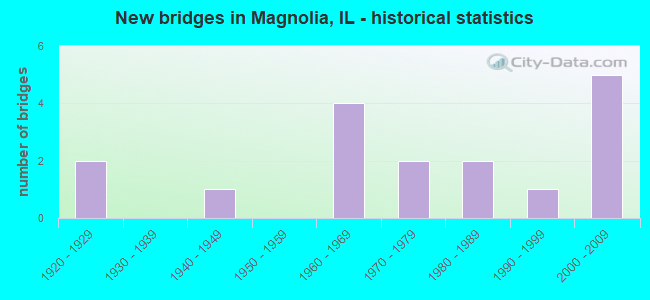
- New bridges - historical statistics
- 21920-1929
- 11940-1949
- 41960-1969
- 21970-1979
- 21980-1989
- 11990-1999
- 52000-2009

- Reconstructed bridges - Historical Statistics
- 21970-1979
- 11980-1989


- Bridge Condition - Deck
- 6.7%Very good
- 33.3%Good
- 26.7%Satisfactory
- 13.3%Fair
- 13.3%Poor
- 6.7%Serious

- Bridge Condition - Superstructure
- 6.7%Very good
- 40.0%Good
- 20.0%Satisfactory
- 13.3%Fair
- 13.3%Poor
- 6.7%Serious

- Bridge Condition - Substructure
- 13.3%Very good
- 26.7%Good
- 26.7%Satisfactory
- 20.0%Fair
- 13.3%Poor

- Bridge Condition - Channel
- 23.5%Very good
- 5.9%Good
- 41.2%Satisfactory
- 17.6%Fair
- 11.8%Poor

- Bridge Condition - Culverts
- 50.0%Very good
- 50.0%Good
Find on map >> Show street view
Structure Number: 502033, Location: 3.03 MI E OF ILL 89 (Lat: 41.118689, Lng: -89.143792), Route carried "on" structure: State highway 18, Year Built: 1999, Status: Open, Structure Length: 0.78m (2.56ft), Average Daily Traffic: 3,100 (year 2021), Truck Traffic: 9%, Average Future Daily Traffic: 1,955 (year 2032), Design Load: HS 20, Features Intersected: DRAINAGE DITCH
Minimum Vertical Clearance: 30+ m (98+ ft), Kilometerpoint: 20.905, Lanes on structure: 2, Base Highway Network: Yes, Owner: State Highway Agency, Approaching Roadway Width: 12.2m (40.0ft), Material/Design: Concrete, Design/Construction: Culvert, Number Of Spans In Main Unit: 2, Length of Maximum Span: 3.6m (11.8ft)
Condition: Channel: Very good, Culverts: Good, Operating Rating: 70.0 metric tons, Method Used To Determine Operating Rating: Load Factor (LF) rating reported by rating factor (RF) method using MS18 loading, Inventory Rating: 42.1 metric tons, Method Used To Determine Inventory Rating: Load Factor (LF) rating reported by rating factor (RF) method using MS18 loading, Structural Evaluation: Better than present minimum criteria, Waterway Adequacy: Equal to present desirable criteria, Approach Roadway Alignment: Equal to present desirable criteria, Designated Inspection Frequency: Every 48 months, Inspection Date: Febuary 2021, Wearing Surface/Protective System: Wearing Surface: Bituminous
Find on map >> Show street view
Structure Number: 503073, Location: E 1ST N 1290 (Lat: 41.118253, Lng: -89.143214), Route carried "on" structure: County highway , Year Built: 1963, Status: Open, Structure Length: 1.22m (4.00ft), Average Daily Traffic: 10 (year 2016), Average Future Daily Traffic: 11 (year 2032), Design Load: HS 15, Features Intersected: SANDY CREEK, Facility Carried by Structure: TR-18-A
Minimum Vertical Clearance: 30+ m (98+ ft), Kilometerpoint: 8.224, Lanes on structure: 2, Owner: Town or Township Highway Agency, Approaching Roadway Width: 4.9m (16.1ft), Material/Design: Concrete, Design/Construction: Channel Beam, Number Of Spans In Main Unit: 1, Length of Maximum Span: 11.6m (38.1ft), Curb-To-Curb Width: 7.4m (24.3ft), Out-to-Out Width: 8.0m (26.2ft)
Condition: Deck: Good, Superstructure: Good, Substructure: Poor, Channel: Good, Operating Rating: 34.3 metric tons, Method Used To Determine Operating Rating: Load Factor (LF) rating reported by rating factor (RF) method using MS18 loading, Structural Evaluation: High priority of corrective action, Deck Geometry: Equal to present minimum criteria, Waterway Adequacy: Better than present minimum criteria, Approach Roadway Alignment: Equal to present desirable criteria, Designated Inspection Frequency: Every 24 months, Inspection Date: June 2020, Deck Structure Type: Concrete Precast Panels
Find on map >> Show street view
Structure Number: 503575, Location: E 1ST, N 1330 (Lat: 41.123469, Lng: -89.143328), Route carried "on" structure: County highway , Year Built: 2002, Status: Open, Structure Length: 1.80m (5.91ft), Average Daily Traffic: 10 (year 2016), Average Future Daily Traffic: 11 (year 2032), Design Load: HS 20, Features Intersected: LITTLE SANDY CREEK, Facility Carried by Structure: TR 18A
Minimum Vertical Clearance: 30+ m (98+ ft), Kilometerpoint: 7.644, Lanes on structure: 2, Owner: Town or Township Highway Agency, Approaching Roadway Width: 7.3m (24.0ft), Skew: 3 degrees, Material/Design: Prestressed concrete, Design/Construction: Box Beam or Girders - Multiple, Number Of Spans In Main Unit: 1, Length of Maximum Span: 18.0m (59.1ft), Curb-To-Curb Width: 7.3m (24.0ft), Out-to-Out Width: 7.3m (24.0ft)
Condition: Deck: Very good, Superstructure: Very good, Substructure: Very good, Channel: Very good, Operating Rating: 44.1 metric tons, Method Used To Determine Operating Rating: Assigned rating based on Load Factor Design (LFD) reported by rating factor (RF) using MS18 loading, Inventory Rating: 32.4 metric tons, Method Used To Determine Inventory Rating: Assigned rating based on Load Factor Design (LFD) reported by rating factor (RF) using MS18 loading, Structural Evaluation: Equal to present desirable criteria, Deck Geometry: Equal to present minimum criteria, Waterway Adequacy: Superior to present desirable criteria, Approach Roadway Alignment: Equal to present desirable criteria, Designated Inspection Frequency: Every 48 months, Inspection Date: June 2018, Deck Structure Type: Concrete Precast Panels
Find on map >> Show street view
Structure Number: 50359, Location: N 14TH E 010 (Lat: 41.133153, Lng: -89.160075), Route carried "on" structure: County highway , Year Built: 2005, Status: Open, Structure Length: 1.09m (3.58ft), Average Daily Traffic: 25 (year 2016), Average Future Daily Traffic: 28 (year 2032), Design Load: HS 20, Features Intersected: BR LITTLE SANDY CR, Facility Carried by Structure: TR 525
Minimum Vertical Clearance: 30+ m (98+ ft), Kilometerpoint: 0.193, Lanes on structure: 2, Owner: Town or Township Highway Agency, Approaching Roadway Width: 7.9m (25.9ft), Material/Design: Aluminum, Iron, Design/Construction: Culvert, Number Of Spans In Main Unit: 1, Length of Maximum Span: 7.4m (24.3ft)
Condition: Channel: Very good, Culverts: Very good, Operating Rating: 44.1 metric tons, Method Used To Determine Operating Rating: Assigned rating based on Load Factor Design (LFD) reported by rating factor (RF) using MS18 loading, Inventory Rating: 32.4 metric tons, Method Used To Determine Inventory Rating: Assigned rating based on Load Factor Design (LFD) reported by rating factor (RF) using MS18 loading, Structural Evaluation: Equal to present desirable criteria, Waterway Adequacy: Equal to present desirable criteria, Approach Roadway Alignment: Equal to present minimum criteria, Designated Inspection Frequency: Every 24 months, Inspection Date: June 2020
Find on map >> Show street view
Structure Number: 620029, Location: 1.87 MI S OF ILL 18 (Lat: 41.091797, Lng: -89.203806), Route carried "on" structure: State highway 89, Year Built: 1928, Year Reconstructed: 1980, Status: Open, Structure Length: 8.66m (28.41ft), Average Daily Traffic: 2,050 (year 2021), Truck Traffic: 18%, Average Future Daily Traffic: 1,671 (year 2032), Design Load: HS 20, Features Intersected: SANDY CREEK
Minimum Vertical Clearance: 30+ m (98+ ft), Kilometerpoint: 37.706, Lanes on structure: 2, Base Highway Network: Yes, Owner: State Highway Agency, Approaching Roadway Width: 7.9m (25.9ft), Skew: 4 degrees, Material/Design: Prestressed concrete continuous, Design/Construction: Stringer/Multi-beam, Number Of Spans In Main Unit: 2, Number Of Approach Spans: 2, Length of Maximum Span: 31.2m (102.4ft), Curb-To-Curb Width: 9.8m (32.2ft), Out-to-Out Width: 10.4m (34.1ft)
Condition: Deck: Fair, Superstructure: Fair, Substructure: Fair, Channel: Fair, Operating Rating: 56.7 metric tons, Method Used To Determine Operating Rating: Load Factor (LF) rating reported by rating factor (RF) method using MS18 loading, Inventory Rating: 35.3 metric tons, Method Used To Determine Inventory Rating: Load Factor (LF) rating reported by rating factor (RF) method using MS18 loading, Structural Evaluation: Somewhat better than minimum adequacy, Deck Geometry: Meets minimum limits, Waterway Adequacy: Equal to present desirable criteria, Approach Roadway Alignment: Equal to present minimum criteria, Designated Inspection Frequency: Every 24 months, Inspection Date: March 2021, Deck Structure Type: Concrete Cast-file-Place, Wearing Surface/Protective System: Deck Protection: Epoxy Coated Reinforcing
Find on map >> Show street view
Structure Number: 624437, Location: T30N-R1W-3PM SEC 4 (Lat: 41.103897, Lng: -89.224167), Route carried "on" structure: County highway , Year Built: 1977, Status: Open, Structure Length: 1.68m (5.51ft), Average Daily Traffic: 50 (year 2019), Truck Traffic: 40%, Average Future Daily Traffic: 56 (year 2032), Design Load: HS 20, Features Intersected: LITTLE SANDY CREEK, Facility Carried by Structure: TR 17 (TH-C57)
Minimum Vertical Clearance: 30+ m (98+ ft), Kilometerpoint: 0.966, Lanes on structure: 2, Owner: Town or Township Highway Agency, Approaching Roadway Width: 7.9m (25.9ft), Material/Design: Prestressed concrete, Design/Construction: Box Beam or Girders - Multiple, Number Of Spans In Main Unit: 1, Length of Maximum Span: 16.2m (53.1ft), Curb-To-Curb Width: 7.3m (24.0ft), Out-to-Out Width: 8.0m (26.2ft)
Condition: Deck: Serious, Superstructure: Serious, Substructure: Poor, Channel: Poor, Operating Rating: 50.5 metric tons, Method Used To Determine Operating Rating: Load Factor (LF) rating reported by rating factor (RF) method using MS18 loading, Inventory Rating: 30.1 metric tons, Method Used To Determine Inventory Rating: Load Factor (LF) rating reported by rating factor (RF) method using MS18 loading, Structural Evaluation: High priority of corrective action, Deck Geometry: Equal to present minimum criteria, Waterway Adequacy: Equal to present minimum criteria, Approach Roadway Alignment: Equal to present desirable criteria, Designated Inspection Frequency: Every 24 months, Other Special Inspection Frequency: Every 12 months, Inspection Date: March 2021, Other Special Inspection Date: March 2021, Deck Structure Type: Concrete Precast Panels
Find on map >> Show street view
Structure Number: 624439, Location: T30N-R1W-3PM SEC 4 (Lat: 41.091111, Lng: -89.225617), Route carried "on" structure: County highway , Year Built: 1978, Status: Open, Structure Length: 4.69m (15.39ft), Average Daily Traffic: 25 (year 2019), Average Future Daily Traffic: 56 (year 2032), Design Load: HS 20+Mod, Features Intersected: SANDY CREEK, Facility Carried by Structure: TR 110 (TH-C59)
Minimum Vertical Clearance: 30+ m (98+ ft), Kilometerpoint: 2.140, Lanes on structure: 2, Owner: Town or Township Highway Agency, Approaching Roadway Width: 8.5m (27.9ft), Skew: 2 degrees, Material/Design: Prestressed concrete, Design/Construction: Box Beam or Girders - Multiple, Number Of Spans In Main Unit: 3, Length of Maximum Span: 15.5m (50.9ft), Curb-To-Curb Width: 7.3m (24.0ft), Out-to-Out Width: 7.3m (24.0ft)
Condition: Deck: Good, Superstructure: Good, Substructure: Good, Channel: Fair, Operating Rating: 44.4 metric tons, Method Used To Determine Operating Rating: Assigned rating based on Load Factor Design (LFD) reported by rating factor (RF) using MS18 loading, Inventory Rating: 32.4 metric tons, Method Used To Determine Inventory Rating: Assigned rating based on Load Factor Design (LFD) reported by rating factor (RF) using MS18 loading, Structural Evaluation: Better than present minimum criteria, Deck Geometry: Equal to present minimum criteria, Waterway Adequacy: Somewhat better than minimum adequacy, Approach Roadway Alignment: Equal to present desirable criteria, Designated Inspection Frequency: Every 48 months, Inspection Date: April 2021, Deck Structure Type: Concrete Precast Panels
Find on map >> Show street view
Structure Number: 624453, Location: 1000N, 2394E (Lat: 41.073017, Lng: -89.182572), Route carried "on" structure: County highway , Year Built: 2003, Status: Open, Structure Length: 1.99m (6.53ft), Average Daily Traffic: 50 (year 2019), Truck Traffic: 40%, Average Future Daily Traffic: 84 (year 2032), Design Load: HS 20, Features Intersected: TRIB/SANDY OR JUDD C, Facility Carried by Structure: TR 49
Minimum Vertical Clearance: 30+ m (98+ ft), Kilometerpoint: 2.462, Lanes on structure: 2, Owner: Town or Township Highway Agency, Approaching Roadway Width: 8.5m (27.9ft), Material/Design: Prestressed concrete, Design/Construction: Box Beam or Girders - Multiple, Number Of Spans In Main Unit: 1, Length of Maximum Span: 19.1m (62.7ft), Curb-To-Curb Width: 7.3m (24.0ft), Out-to-Out Width: 7.3m (24.0ft)
Condition: Deck: Good, Superstructure: Good, Substructure: Very good, Channel: Very good, Operating Rating: 44.1 metric tons, Method Used To Determine Operating Rating: Assigned rating based on Load Factor Design (LFD) reported by rating factor (RF) using MS18 loading, Inventory Rating: 32.4 metric tons, Method Used To Determine Inventory Rating: Assigned rating based on Load Factor Design (LFD) reported by rating factor (RF) using MS18 loading, Structural Evaluation: Better than present minimum criteria, Deck Geometry: Equal to present minimum criteria, Waterway Adequacy: Equal to present desirable criteria, Approach Roadway Alignment: Equal to present desirable criteria, Designated Inspection Frequency: Every 48 months, Inspection Date: April 2021, Deck Structure Type: Concrete Precast Panels
Find on map >> Show street view
Structure Number: 6245, Location: FAS 2368 OV SANDY CR (Lat: 41.089553, Lng: -89.162164), Route carried "on" structure: County highway , Year Built: 1969, Status: Open, Structure Length: 3.63m (11.91ft), Average Daily Traffic: 150 (year 2016), Truck Traffic: 15%, Average Future Daily Traffic: 362 (year 2032), Design Load: HS 15, Features Intersected: SANDY CREEK, Facility Carried by Structure: FAS 2368 (CH-S51)
Minimum Vertical Clearance: 30+ m (98+ ft), Kilometerpoint: 1.609, Lanes on structure: 2, Owner: County Highway Agency, Approaching Roadway Width: 9.1m (29.9ft), Skew: 2 degrees, Material/Design: Prestressed concrete, Design/Construction: Box Beam or Girders - Multiple, Number Of Spans In Main Unit: 3, Length of Maximum Span: 14.6m (47.9ft), Curb-To-Curb Width: 7.3m (24.0ft), Out-to-Out Width: 8.0m (26.2ft)
Condition: Deck: Poor, Superstructure: Poor, Substructure: Satisfactory, Channel: Satisfactory, Operating Rating: 56.7 metric tons, Method Used To Determine Operating Rating: Load Factor (LF) rating reported by rating factor (RF) method using MS18 loading, Inventory Rating: 21.7 metric tons, Method Used To Determine Inventory Rating: Load Factor (LF) rating reported by rating factor (RF) method using MS18 loading, Structural Evaluation: Meets minimum limits, Deck Geometry: Somewhat better than minimum adequacy, Waterway Adequacy: Better than present minimum criteria, Approach Roadway Alignment: Equal to present desirable criteria, Designated Inspection Frequency: Every 24 months, Inspection Date: April 2021, Deck Structure Type: Concrete Precast Panels, Wearing Surface/Protective System: Wearing Surface: Bituminous
Find on map >> Show street view
Structure Number: 624501, Location: FAS 2368 OV JUDD CR (Lat: 41.085903, Lng: -89.162142), Route carried "on" structure: County highway , Year Built: 1969, Status: Open, Structure Length: 2.93m (9.61ft), Average Daily Traffic: 150 (year 2016), Truck Traffic: 15%, Average Future Daily Traffic: 362 (year 2032), Design Load: HS 15, Features Intersected: JUDD CREEK, Facility Carried by Structure: FAS 2368 (CH-S51)
Minimum Vertical Clearance: 30+ m (98+ ft), Kilometerpoint: 2.012, Lanes on structure: 2, Owner: County Highway Agency, Approaching Roadway Width: 9.1m (29.9ft), Skew: 3 degrees, Material/Design: Concrete, Design/Construction: Channel Beam, Number Of Spans In Main Unit: 3, Length of Maximum Span: 9.8m (32.2ft), Curb-To-Curb Width: 7.4m (24.3ft), Out-to-Out Width: 8.0m (26.2ft)
Condition: Deck: Fair, Superstructure: Fair, Substructure: Satisfactory, Channel: Satisfactory, Operating Rating: 48.3 metric tons, Method Used To Determine Operating Rating: Load Factor (LF) rating reported by rating factor (RF) method using MS18 loading, Inventory Rating: 28.8 metric tons, Method Used To Determine Inventory Rating: Load Factor (LF) rating reported by rating factor (RF) method using MS18 loading, Structural Evaluation: Somewhat better than minimum adequacy, Deck Geometry: Somewhat better than minimum adequacy, Waterway Adequacy: Better than present minimum criteria, Approach Roadway Alignment: Equal to present minimum criteria, Designated Inspection Frequency: Every 24 months, Inspection Date: April 2021, Deck Structure Type: Concrete Precast Panels, Wearing Surface/Protective System: Wearing Surface: Bituminous
Find on map >> Show street view
Structure Number: 624551, Location: T30N-R1E-3PM SEC 7 (Lat: 41.081864, Lng: -89.155947), Route carried "on" structure: County highway , Year Built: 1980, Status: Open, Structure Length: 2.32m (7.61ft), Average Daily Traffic: 75 (year 2019), Truck Traffic: 27%, Average Future Daily Traffic: 84 (year 2032), Design Load: HS 20, Features Intersected: JUDD CREEK, Facility Carried by Structure: TR 37 (TH-C60)
Minimum Vertical Clearance: 30+ m (98+ ft), Kilometerpoint: 0.515, Lanes on structure: 2, Owner: Town or Township Highway Agency, Approaching Roadway Width: 8.5m (27.9ft), Skew: 2 degrees, Material/Design: Prestressed concrete, Design/Construction: Box Beam or Girders - Multiple, Number Of Spans In Main Unit: 1, Length of Maximum Span: 23.2m (76.1ft), Curb-To-Curb Width: 7.3m (24.0ft), Out-to-Out Width: 7.4m (24.3ft)
Condition: Deck: Satisfactory, Superstructure: Satisfactory, Substructure: Fair, Channel: Satisfactory, Operating Rating: 44.4 metric tons, Method Used To Determine Operating Rating: Assigned rating based on Load Factor Design (LFD) reported by rating factor (RF) using MS18 loading, Inventory Rating: 32.4 metric tons, Method Used To Determine Inventory Rating: Assigned rating based on Load Factor Design (LFD) reported by rating factor (RF) using MS18 loading, Structural Evaluation: Somewhat better than minimum adequacy, Deck Geometry: Equal to present minimum criteria, Waterway Adequacy: Better than present minimum criteria, Approach Roadway Alignment: Equal to present desirable criteria, Designated Inspection Frequency: Every 24 months, Inspection Date: April 2021, Deck Structure Type: Concrete Precast Panels, Wearing Surface/Protective System: Wearing Surface: Bituminous
Find on map >> Show street view
Structure Number: 780025, Location: 1.39 MI N OF ILL 18 (Lat: 41.137881, Lng: -89.206206), Route carried "on" structure: State highway 89, Year Built: 1928, Year Reconstructed: 1970, Status: Open, Structure Length: 0.79m (2.59ft), Average Daily Traffic: 1,650 (year 2021), Truck Traffic: 15%, Average Future Daily Traffic: 1,435 (year 2032), Features Intersected: CLEAR CREEK
Minimum Vertical Clearance: 30+ m (98+ ft), Kilometerpoint: 42.952, Lanes on structure: 2, Base Highway Network: Yes, Owner: State Highway Agency, Approaching Roadway Width: 7.9m (25.9ft), Material/Design: Concrete, Design/Construction: Slab, Number Of Spans In Main Unit: 1, Length of Maximum Span: 7.6m (24.9ft), Curb-To-Curb Width: 12.9m (42.3ft), Out-to-Out Width: 12.9m (42.3ft)
Condition: Deck: Poor, Superstructure: Poor, Substructure: Fair, Channel: Fair, Operating Rating: 51.2 metric tons, Method Used To Determine Operating Rating: Load Factor (LF) rating reported by rating factor (RF) method using MS18 loading, Inventory Rating: 30.8 metric tons, Method Used To Determine Inventory Rating: Load Factor (LF) rating reported by rating factor (RF) method using MS18 loading, Structural Evaluation: Meets minimum limits, Deck Geometry: Better than present minimum criteria, Waterway Adequacy: Better than present minimum criteria, Approach Roadway Alignment: Equal to present desirable criteria, Designated Inspection Frequency: Every 12 months, Inspection Date: Febuary 2021, Deck Structure Type: Concrete Cast-file-Place, Wearing Surface/Protective System: Wearing Surface: Bituminous, Membrane: Built-up
Find on map >> Show street view
Structure Number: 780038, Location: 0.05 MI N OF IL 18 (Lat: 41.119133, Lng: -89.202108), Route carried "on" structure: State highway 89, Year Built: 2001, Status: Open, Structure Length: 3.85m (12.63ft), Average Daily Traffic: 1,650 (year 2021), Truck Traffic: 15%, Average Future Daily Traffic: 1,435 (year 2032), Design Load: HS 20, Features Intersected: LITTLE SANDY CREEK
Minimum Vertical Clearance: 30+ m (98+ ft), Kilometerpoint: 40.796, Lanes on structure: 2, Base Highway Network: Yes, Owner: State Highway Agency, Approaching Roadway Width: 9.8m (32.2ft), Skew: 2 degrees, Material/Design: Steel continuous, Design/Construction: Stringer/Multi-beam, Number Of Spans In Main Unit: 3, Length of Maximum Span: 14.0m (45.9ft), Curb-To-Curb Width: 10.2m (33.5ft), Out-to-Out Width: 11.2m (36.7ft)
Condition: Deck: Satisfactory, Superstructure: Good, Substructure: Good, Channel: Satisfactory, Operating Rating: 89.1 metric tons, Method Used To Determine Operating Rating: Load Factor (LF) rating reported by rating factor (RF) method using MS18 loading, Inventory Rating: 58.3 metric tons, Method Used To Determine Inventory Rating: Load Factor (LF) rating reported by rating factor (RF) method using MS18 loading, Structural Evaluation: Better than present minimum criteria, Deck Geometry: Somewhat better than minimum adequacy, Waterway Adequacy: Equal to present minimum criteria, Approach Roadway Alignment: Equal to present minimum criteria, Designated Inspection Frequency: Every 48 months, Inspection Date: January 2021, Deck Structure Type: Concrete Cast-file-Place, Wearing Surface/Protective System: Deck Protection: Epoxy Coated Reinforcing
Find on map >> Show street view
Structure Number: 780039, Location: 50FT W of IL 89 (Lat: 41.118494, Lng: -89.202283), Route carried "on" structure: State highway 18, Year Built: 2005, Status: Open, Structure Length: 3.78m (12.40ft), Average Daily Traffic: 2,200 (year 2021), Truck Traffic: 11%, Average Future Daily Traffic: 1,230 (year 2032), Design Load: HS 20, Features Intersected: LITTLE SANDY CREEK
Minimum Vertical Clearance: 30+ m (98+ ft), Kilometerpoint: 15.980, Lanes on structure: 2, Base Highway Network: Yes, Owner: State Highway Agency, Approaching Roadway Width: 9.8m (32.2ft), Material/Design: Concrete continuous, Design/Construction: Slab, Number Of Spans In Main Unit: 3, Length of Maximum Span: 14.2m (46.6ft), Curb-To-Curb Width: 9.8m (32.2ft), Out-to-Out Width: 10.7m (35.1ft)
Condition: Deck: Good, Superstructure: Good, Substructure: Good, Channel: Satisfactory, Operating Rating: 63.2 metric tons, Method Used To Determine Operating Rating: Load Factor (LF) rating reported by rating factor (RF) method using MS18 loading, Inventory Rating: 37.9 metric tons, Method Used To Determine Inventory Rating: Load Factor (LF) rating reported by rating factor (RF) method using MS18 loading, Structural Evaluation: Better than present minimum criteria, Deck Geometry: Meets minimum limits, Waterway Adequacy: Equal to present desirable criteria, Approach Roadway Alignment: Equal to present minimum criteria, Designated Inspection Frequency: Every 48 months, Inspection Date: October 2019, Deck Structure Type: Concrete Cast-file-Place, Wearing Surface/Protective System: Deck Protection: Epoxy Coated Reinforcing
Find on map >> Show street view
Structure Number: 783004, Location: 140N, 1600E (Lat: 41.125269, Lng: -89.162350), Route carried "on" structure: County highway , Year Built: 1940, Year Reconstructed: 1984, Status: Open, Structure Length: 1.34m (4.40ft), Average Daily Traffic: 50 (year 2016), Average Future Daily Traffic: 56 (year 2032), Design Load: HS 20, Features Intersected: SANDY CREEK, Facility Carried by Structure: TR 2 A
Minimum Vertical Clearance: 30+ m (98+ ft), Kilometerpoint: 5.761, Lanes on structure: 1, Owner: Town or Township Highway Agency, Approaching Roadway Width: 7.9m (25.9ft), Material/Design: Prestressed concrete, Design/Construction: Box Beam or Girders - Multiple, Number Of Spans In Main Unit: 1, Length of Maximum Span: 12.5m (41.0ft), Curb-To-Curb Width: 7.3m (24.0ft), Out-to-Out Width: 7.3m (24.0ft)
Condition: Deck: Good, Superstructure: Good, Substructure: Satisfactory, Channel: Poor, Operating Rating: 71.0 metric tons, Method Used To Determine Operating Rating: Load Factor (LF) rating reported by rating factor (RF) method using MS18 loading, Inventory Rating: 42.4 metric tons, Method Used To Determine Inventory Rating: Load Factor (LF) rating reported by rating factor (RF) method using MS18 loading, Structural Evaluation: Equal to present minimum criteria, Deck Geometry: Equal to present minimum criteria, Waterway Adequacy: Better than present minimum criteria, Approach Roadway Alignment: Equal to present desirable criteria, Designated Inspection Frequency: Every 24 months, Inspection Date: July 2020, Deck Structure Type: Concrete Precast Panels
Find on map >> Show street view
Structure Number: 783015, Location: 135N, 1540E (Lat: 41.124228, Lng: -89.174403), Route carried "on" structure: County highway , Year Built: 1967, Status: Open, Structure Length: 1.52m (4.99ft), Average Daily Traffic: 25 (year 2018), Average Future Daily Traffic: 26 (year 2032), Design Load: H 15, Features Intersected: STREAM, Facility Carried by Structure: TR 85
Minimum Vertical Clearance: 30+ m (98+ ft), Kilometerpoint: 1.609, Lanes on structure: 1, Owner: Town or Township Highway Agency, Approaching Roadway Width: 7.3m (24.0ft), Material/Design: Concrete, Design/Construction: Channel Beam, Number Of Spans In Main Unit: 3, Length of Maximum Span: 4.9m (16.1ft), Curb-To-Curb Width: 7.4m (24.3ft), Out-to-Out Width: 8.0m (26.2ft)
Condition: Deck: Satisfactory, Superstructure: Satisfactory, Substructure: Satisfactory, Channel: Satisfactory, Operating Rating: 40.5 metric tons, Method Used To Determine Operating Rating: Load Factor (LF) rating reported by rating factor (RF) method using MS18 loading, Inventory Rating: 24.3 metric tons, Method Used To Determine Inventory Rating: Load Factor (LF) rating reported by rating factor (RF) method using MS18 loading, Structural Evaluation: Equal to present minimum criteria, Deck Geometry: Equal to present minimum criteria, Waterway Adequacy: Better than present minimum criteria, Approach Roadway Alignment: Equal to present desirable criteria, Designated Inspection Frequency: Every 24 months, Inspection Date: July 2020, Deck Structure Type: Concrete Precast Panels
Find on map >> Show street view
Structure Number: 783105, Location: 1450E 130N (Lat: 41.123369, Lng: -89.191522), Route carried "on" structure: County highway , Year Built: 1985, Status: Open, Structure Length: 1.98m (6.50ft), Average Daily Traffic: 25 (year 2018), Average Future Daily Traffic: 26 (year 2032), Design Load: HS 20, Features Intersected: LITTLE SANDY CR, Facility Carried by Structure: TR 98
Minimum Vertical Clearance: 30+ m (98+ ft), Kilometerpoint: 6.212, Lanes on structure: 2, Owner: Town or Township Highway Agency, Approaching Roadway Width: 7.3m (24.0ft), Skew: 1 degrees, Material/Design: Prestressed concrete, Design/Construction: Box Beam or Girders - Multiple, Number Of Spans In Main Unit: 1, Length of Maximum Span: 18.9m (62.0ft), Curb-To-Curb Width: 7.4m (24.3ft), Out-to-Out Width: 7.4m (24.3ft)
Condition: Deck: Satisfactory, Superstructure: Satisfactory, Substructure: Good, Channel: Satisfactory, Operating Rating: 44.4 metric tons, Method Used To Determine Operating Rating: Assigned rating based on Load Factor Design (LFD) reported by rating factor (RF) using MS18 loading, Inventory Rating: 32.4 metric tons, Method Used To Determine Inventory Rating: Assigned rating based on Load Factor Design (LFD) reported by rating factor (RF) using MS18 loading, Structural Evaluation: Equal to present minimum criteria, Deck Geometry: Equal to present minimum criteria, Waterway Adequacy: Better than present minimum criteria, Approach Roadway Alignment: Better than present minimum criteria, Designated Inspection Frequency: Every 24 months, Inspection Date: July 2020, Deck Structure Type: Concrete Precast Panels