Bridge Statistics for Madison, New Jersey (NJ)
Condition, Traffic, Stress, Structural Evaluation, Project Costs
- National Bridge Inventory (NBI) Statistics
- 15Number of bridges
- 92ft / 28.0mTotal length
- $41,738,000Total costs
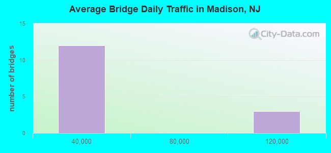
- 341,270Total average daily traffic
- 16,214Total average daily truck traffic
- National Bridge Inventory (NBI) Registered Bridges for Madison
- No street view available for this location
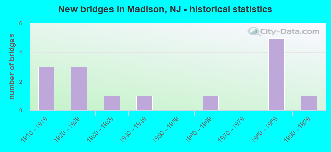
- New bridges - historical statistics
- 31910-1919
- 31920-1929
- 11930-1939
- 11940-1949
- 11960-1969
- 51980-1989
- 11990-1999
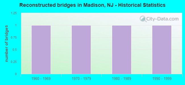
- Reconstructed bridges - Historical Statistics
- 11960-1969
- 11970-1979
- 11980-1989
- 11990-1999
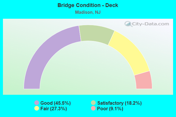
- Bridge Condition - Deck
- 45.5%Good
- 18.2%Satisfactory
- 27.3%Fair
- 9.1%Poor
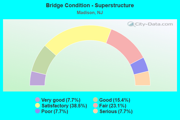
- Bridge Condition - Superstructure
- 7.7%Very good
- 15.4%Good
- 38.5%Satisfactory
- 23.1%Fair
- 7.7%Poor
- 7.7%Serious
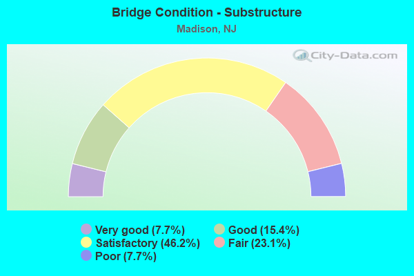
- Bridge Condition - Substructure
- 7.7%Very good
- 15.4%Good
- 46.2%Satisfactory
- 23.1%Fair
- 7.7%Poor
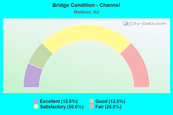
- Bridge Condition - Channel
- 12.5%Excellent
- 12.5%Good
- 50.0%Satisfactory
- 25.0%Fair
Find on map >> Show street view
Structure Number: 1400473, Location: 1.6MI S OF I287&NJ124 JCT (Lat: 40.767739, Lng: -74.454800), Route carried "on" structure: City street , Year Built: 1927, Year Reconstructed: 1971, Status: Open, Structure Length: 1.04m (3.41ft), Average Daily Traffic: 1,027 (year 2021), Truck Traffic: 3%, Average Future Daily Traffic: 1,253 (year 2041), Features Intersected: LOANTAKA BROOK, Facility Carried by Structure: KITCHELL ROAD
Minimum Vertical Clearance: 30+ m (98+ ft), Kilometerpoint: 0.402, Lanes on structure: 2, Owner: County Highway Agency, Approaching Roadway Width: 6.1m (20.0ft), Material/Design: Steel, Design/Construction: Stringer/Multi-beam, Number Of Spans In Main Unit: 1, Length of Maximum Span: 9.4m (30.8ft), Curb-To-Curb Width: 11.0m (36.1ft), Out-to-Out Width: 11.2m (36.7ft)
Condition: Deck: Satisfactory, Superstructure: Fair, Substructure: Satisfactory, Channel: Fair, Operating Rating: 48.1 metric tons, Method Used To Determine Operating Rating: Load Factor (LF), Inventory Rating: 29.0 metric tons, Method Used To Determine Inventory Rating: Load Factor (LF), Structural Evaluation: Somewhat better than minimum adequacy, Deck Geometry: Equal to present minimum criteria, Waterway Adequacy: Equal to present desirable criteria, Approach Roadway Alignment: Meets minimum limits, Designated Inspection Frequency: Every 24 months, Inspection Date: July 2021, Deck Structure Type: Corrugated Steel, Wearing Surface/Protective System: Wearing Surface: Bituminous
Find on map >> Show street view
Structure Number: 1400488, Location: 1.6 MI E CR646&CR663 JCT (Lat: 40.749419, Lng: -74.465569), Route carried "on" structure: City street , Year Built: 1919, Year Reconstructed: 1995, Status: Open, Structure Length: 1.01m (3.31ft), Average Daily Traffic: 5,828 (year 2021), Truck Traffic: 3%, Average Future Daily Traffic: 7,111 (year 2041), Design Load: HS 25 or greater, Features Intersected: GREAT BROOK, Facility Carried by Structure: BLUE MILL ROAD
Minimum Vertical Clearance: 30+ m (98+ ft), Kilometerpoint: 1.577, Lanes on structure: 2, Owner: County Highway Agency, Approaching Roadway Width: 7.3m (24.0ft), Material/Design: Prestressed concrete, Design/Construction: Box Beam or Girders - Multiple, Number Of Spans In Main Unit: 1, Length of Maximum Span: 9.1m (29.9ft), Curb-To-Curb Width: 6.6m (21.7ft), Out-to-Out Width: 8.0m (26.2ft)
Condition: Deck: Good, Superstructure: Good, Substructure: Fair, Channel: Satisfactory, Inventory Rating: 57.2 metric tons, Method Used To Determine Inventory Rating: Load Factor (LF), Structural Evaluation: Somewhat better than minimum adequacy, Deck Geometry: High priority of replacement, Waterway Adequacy: Better than present minimum criteria, Approach Roadway Alignment: Equal to present minimum criteria, Length Of Structure Improvement: 1.01m (3.31ft), Designated Inspection Frequency: Every 24 months, Inspection Date: July 2021, Bridge Improvement Cost: $316,000, Roadway Improvement Cost: $30,000, Total Project Cost: $457,000 ( Estimate for 2021), Deck Structure Type: Concrete Cast-file-Place, Wearing Surface/Protective System: Wearing Surface: Monolithic Concrete, Deck Protection: Epoxy Coated Reinforcing
Find on map >> Show street view
Structure Number: 140049, Location: 0.2MI N CR601&CR646 JCT (Lat: 40.743431, Lng: -74.459131), Route carried "on" structure: City street , Year Built: 1923, Year Reconstructed: 1984, Status: Open, Structure Length: 1.04m (3.41ft), Average Daily Traffic: 668 (year 2019), Truck Traffic: 1%, Average Future Daily Traffic: 815 (year 2039), Features Intersected: SILVER BROOK, Facility Carried by Structure: DICKSON'S MILL RD
Minimum Vertical Clearance: 30+ m (98+ ft), Kilometerpoint: 0.000, Lanes on structure: 2, Owner: County Highway Agency, Approaching Roadway Width: 6.7m (22.0ft), Skew: 2 degrees, Material/Design: Prestressed concrete, Design/Construction: Slab, Number Of Spans In Main Unit: 1, Length of Maximum Span: 9.1m (29.9ft), Curb or Sidewalk Widths: Left: 0.3m (1.0ft), Right: 0.3m (1.0ft), Curb-To-Curb Width: 6.2m (20.3ft), Out-to-Out Width: 7.4m (24.3ft)
Condition: Deck: Poor, Superstructure: Poor, Substructure: Fair, Channel: Satisfactory, Operating Rating: 41.7 metric tons, Method Used To Determine Operating Rating: Load Factor (LF), Inventory Rating: 25.4 metric tons, Method Used To Determine Inventory Rating: Load Factor (LF), Structural Evaluation: Meets minimum limits, Deck Geometry: High priority of corrective action, Waterway Adequacy: Better than present minimum criteria, Approach Roadway Alignment: Somewhat better than minimum adequacy, Length Of Structure Improvement: 1.04m (3.41ft), Designated Inspection Frequency: Every 24 months, Inspection Date: July 2021, Bridge Improvement Cost: $512,000, Roadway Improvement Cost: $30,000, Total Project Cost: $801,000 ( Estimate for 2021), Deck Structure Type: Concrete Precast Panels, Wearing Surface/Protective System: Wearing Surface: Bituminous
Find on map >> Show street view
Structure Number: 1400492, Location: 1.7MI SW CR646&CR647 JCT (Lat: 40.734581, Lng: -74.458389), Route carried "on" structure: City street , Year Built: 1921, Year Reconstructed: 1985, Status: Open, Structure Length: 0.76m (2.49ft), Average Daily Traffic: 1,245 (year 2021), Truck Traffic: 1%, Average Future Daily Traffic: 1,519 (year 2041), Features Intersected: GREAT BROOK, Facility Carried by Structure: WOODLAND ROAD
Minimum Vertical Clearance: 30+ m (98+ ft), Kilometerpoint: 0.000, Lanes on structure: 1, Owner: County Highway Agency, Approaching Roadway Width: 6.1m (20.0ft), Skew: 1 degrees, Material/Design: Steel, Design/Construction: Stringer/Multi-beam, Number Of Spans In Main Unit: 1, Length of Maximum Span: 7.3m (24.0ft), Curb-To-Curb Width: 5.2m (17.1ft), Out-to-Out Width: 5.7m (18.7ft)
Condition: Deck: Fair, Superstructure: Satisfactory, Substructure: Good, Channel: Satisfactory, Inventory Rating: 75.3 metric tons, Method Used To Determine Inventory Rating: Load Factor (LF), Structural Evaluation: Equal to present minimum criteria, Deck Geometry: High priority of replacement, Waterway Adequacy: Equal to present minimum criteria, Approach Roadway Alignment: Equal to present minimum criteria, Length Of Structure Improvement: 0.76m (2.49ft), Designated Inspection Frequency: Every 24 months, Inspection Date: July 2021, Bridge Improvement Cost: $158,000, Roadway Improvement Cost: $24,000, Total Project Cost: $270,000 ( Estimate for 2021), Deck Structure Type: Corrugated Steel, Wearing Surface/Protective System: Wearing Surface: Bituminous
Find on map >> Show street view
Structure Number: 1400506, Location: 0.9MI SW CR646&CR647 JCT (Lat: 40.738500, Lng: -74.446019), Route carried "on" structure: County highway 646, Year Built: 1936, Status: Open, Structure Length: 1.16m (3.81ft), Average Daily Traffic: 6,512 (year 2021), Truck Traffic: 3%, Average Future Daily Traffic: 7,946 (year 2041), Features Intersected: LOANTAKA BROOK
Minimum Vertical Clearance: 30+ m (98+ ft), Kilometerpoint: 14.259, Lanes on structure: 2, Owner: County Highway Agency, Approaching Roadway Width: 10.4m (34.1ft), Material/Design: Steel, Design/Construction: Stringer/Multi-beam, Number Of Spans In Main Unit: 1, Length of Maximum Span: 11.0m (36.1ft), Curb or Sidewalk Widths: Left: 1.9m (6.2ft), Right: 1.9m (6.2ft), Curb-To-Curb Width: 10.4m (34.1ft), Out-to-Out Width: 15.2m (49.9ft)
Condition: Deck: Satisfactory, Superstructure: Satisfactory, Substructure: Satisfactory, Channel: Fair, Inventory Rating: 60.8 metric tons, Method Used To Determine Inventory Rating: Load Factor (LF), Structural Evaluation: Equal to present minimum criteria, Deck Geometry: Meets minimum limits, Waterway Adequacy: Equal to present desirable criteria, Approach Roadway Alignment: Equal to present minimum criteria, Length Of Structure Improvement: 1.16m (3.81ft), Designated Inspection Frequency: Every 24 months, Inspection Date: July 2021, Bridge Improvement Cost: $109,000, Total Project Cost: $224,000 ( Estimate for 2021), Deck Structure Type: Concrete Cast-file-Place, Wearing Surface/Protective System: Wearing Surface: Bituminous
Find on map >> Show street view
Structure Number: 1400507, Location: 1.6MI SW CR646&CR647 JCT (Lat: 40.739569, Lng: -74.458700), Route carried "on" structure: County highway 646, Year Built: 1994, Status: Open, Structure Length: 1.01m (3.31ft), Average Daily Traffic: 4,476 (year 2021), Truck Traffic: 3%, Average Future Daily Traffic: 5,462 (year 2041), Design Load: HS 25 or greater, Features Intersected: GREAT BROOK
Minimum Vertical Clearance: 30+ m (98+ ft), Kilometerpoint: 13.100, Lanes on structure: 2, Owner: County Highway Agency, Approaching Roadway Width: 8.5m (27.9ft), Material/Design: Prestressed concrete, Design/Construction: Stringer/Multi-beam, Number Of Spans In Main Unit: 1, Length of Maximum Span: 9.1m (29.9ft), Curb or Sidewalk Widths: Left: 0.2m (0.7ft), Right: 0.2m (0.7ft), Curb-To-Curb Width: 8.5m (27.9ft), Out-to-Out Width: 10.0m (32.8ft)
Condition: Deck: Good, Superstructure: Very good, Substructure: Very good, Channel: Satisfactory, Inventory Rating: 88.0 metric tons, Method Used To Determine Inventory Rating: Load Factor (LF), Structural Evaluation: Equal to present desirable criteria, Deck Geometry: Meets minimum limits, Waterway Adequacy: Superior to present desirable criteria, Approach Roadway Alignment: Better than present minimum criteria, Length Of Structure Improvement: 1.01m (3.31ft), Designated Inspection Frequency: Every 24 months, Inspection Date: July 2021, Bridge Improvement Cost: $119,000, Roadway Improvement Cost: $21,000, Total Project Cost: $209,000 ( Estimate for 2015), Deck Structure Type: Concrete Cast-file-Place, Wearing Surface/Protective System: Wearing Surface: Monolithic Concrete, Deck Protection: Epoxy Coated Reinforcing
Find on map >> Show street view
Structure Number: 1417001, Location: 0.7MI SE NJ124&CR608 JCT (Lat: 40.754350, Lng: -74.402881), Route carried "on" structure: City street , Year Built: 1965, Status: Open, Structure Length: 0.73m (2.40ft), Average Daily Traffic: 552 (year 2019), Truck Traffic: 1%, Average Future Daily Traffic: 674 (year 2039), Design Load: HS 20, Features Intersected: SPRING GARDEN BROOK, Facility Carried by Structure: TRAIL PLACE
Minimum Vertical Clearance: 30+ m (98+ ft), Kilometerpoint: 0.032, Lanes on structure: 2, Owner: Town or Township Highway Agency, Approaching Roadway Width: 9.1m (29.9ft), Material/Design: Prestressed concrete, Design/Construction: Slab, Number Of Spans In Main Unit: 1, Length of Maximum Span: 6.4m (21.0ft), Curb or Sidewalk Widths: Left: 1.9m (6.2ft), Right: 1.9m (6.2ft), Curb-To-Curb Width: 9.1m (29.9ft), Out-to-Out Width: 13.6m (44.6ft)
Condition: Deck: Fair, Superstructure: Fair, Substructure: Satisfactory, Channel: Good, Operating Rating: 54.4 metric tons, Method Used To Determine Operating Rating: Field evaluation and documented engineering judgment, Inventory Rating: 32.7 metric tons, Method Used To Determine Inventory Rating: Field evaluation and documented engineering judgment, Structural Evaluation: Somewhat better than minimum adequacy, Deck Geometry: Equal to present minimum criteria, Waterway Adequacy: Better than present minimum criteria, Approach Roadway Alignment: Equal to present desirable criteria, Designated Inspection Frequency: Every 24 months, Inspection Date: August 2021, Deck Structure Type: Concrete Precast Panels, Wearing Surface/Protective System: Wearing Surface: Bituminous
Find on map >> Show street view
Structure Number: 1422154, Location: 3.1 MI. EAST OF I-287 (Lat: 40.782169, Lng: -74.414919), Route carried "on" structure: State highway 24, Year Built: 1989, Status: Open, Structure Length: 1.89m (6.20ft), Average Daily Traffic: 104,975 (year 2020), Truck Traffic: 5%, Average Future Daily Traffic: 125,970 (year 2040), Design Load: HS 20+Mod, Features Intersected: BLACK BROOK(EAST BRANCH)
Minimum Vertical Clearance: 30+ m (98+ ft), Kilometerpoint: 4.973, Lanes on structure: 4, Base Highway Network: Yes, Owner: State Highway Agency, Approaching Roadway Width: 36.0m (118.1ft), Skew: 32 degrees, Material/Design: Prestressed concrete, Design/Construction: Box Beam or Girders - Multiple, Number Of Spans In Main Unit: 1, Length of Maximum Span: 18.0m (59.1ft), Curb-To-Curb Width: 35.8m (117.5ft), Out-to-Out Width: 37.6m (123.4ft)
Condition: Deck: Good, Superstructure: Satisfactory, Substructure: Satisfactory, Channel: Excellent, Operating Rating: 80.7 metric tons, Method Used To Determine Operating Rating: Load Factor (LF), Inventory Rating: 48.1 metric tons, Method Used To Determine Inventory Rating: Load Factor (LF), Structural Evaluation: Equal to present minimum criteria, Deck Geometry: Superior to present desirable criteria, Waterway Adequacy: Superior to present desirable criteria, Approach Roadway Alignment: Equal to present desirable criteria, Designated Inspection Frequency: Every 24 months, Inspection Date: April 2020, Deck Structure Type: Concrete Cast-file-Place, Wearing Surface/Protective System: Wearing Surface: Bituminous, Membrane: Epoxy, Deck Protection: Epoxy Coated Reinforcing
Find on map >> Show street view
Structure Number: 1422155, Location: 0.66 MI. S. OF CR 608 (Lat: 40.765219, Lng: -74.402250), Route carried "on" structure: City street 24, Year Built: 1989, Status: Open, Structure Length: 6.10m (20.01ft), Average Daily Traffic: 6,024 (year 2021), Truck Traffic: 4%, Average Future Daily Traffic: 7,229 (year 2041), Design Load: HS 20, Features Intersected: NJ ROUTE 24, Facility Carried by Structure: GREENWOOD AVE
Minimum Vertical Clearance: 30+ m (98+ ft), Kilometerpoint: 1.271, Lanes on structure: 2, Lanes under structure: 4, Owner: State Highway Agency, Approaching Roadway Width: 12.5m (41.0ft), Material/Design: Steel continuous, Design/Construction: Stringer/Multi-beam, Number Of Spans In Main Unit: 2, Length of Maximum Span: 30.2m (99.1ft), Curb or Sidewalk Widths: Left: 1.8m (5.9ft), Right: 1.8m (5.9ft), Curb-To-Curb Width: 12.2m (40.0ft), Out-to-Out Width: 16.5m (54.1ft)
Condition: Deck: Good, Superstructure: Good, Substructure: Fair, Inventory Rating: 53.5 metric tons, Method Used To Determine Inventory Rating: Load Factor (LF), Structural Evaluation: Somewhat better than minimum adequacy, Deck Geometry: Somewhat better than minimum adequacy, Underclear: Somewhat better than minimum adequacy, Approach Roadway Alignment: Equal to present desirable criteria, Designated Inspection Frequency: Every 24 months, Inspection Date: March 2021, Deck Structure Type: Concrete Cast-file-Place, Wearing Surface/Protective System: Wearing Surface: Latex Concrete
Find on map >> Show street view
Structure Number: 1422158, Location: 2.06 mi E Int 2 of NJ 24 (Lat: 40.769531, Lng: -74.403189), Route carried "on" structure: City street , Year Built: 1987, Status: Open, Structure Length: 6.19m (20.31ft), Average Daily Traffic: 509 (year 2021), Truck Traffic: 1%, Average Future Daily Traffic: 611 (year 2041), Design Load: HS 20, Features Intersected: ROUTE NJ 24, Facility Carried by Structure: LORRAINE ROAD
Minimum Vertical Clearance: 30+ m (98+ ft), Kilometerpoint: 0.000, Lanes on structure: 2, Lanes under structure: 4, Owner: State Highway Agency, Approaching Roadway Width: 9.1m (29.9ft), Material/Design: Steel continuous, Design/Construction: Stringer/Multi-beam, Number Of Spans In Main Unit: 2, Length of Maximum Span: 30.2m (99.1ft), Curb or Sidewalk Widths: Left: 1.8m (5.9ft), Right: 1.8m (5.9ft), Curb-To-Curb Width: 9.1m (29.9ft), Out-to-Out Width: 13.5m (44.3ft)
Condition: Deck: Good, Superstructure: Satisfactory, Substructure: Good, Operating Rating: 64.4 metric tons, Method Used To Determine Operating Rating: Load Factor (LF), Inventory Rating: 38.1 metric tons, Method Used To Determine Inventory Rating: Load Factor (LF), Structural Evaluation: Equal to present minimum criteria, Deck Geometry: Equal to present minimum criteria, Underclear: Better than present minimum criteria, Approach Roadway Alignment: Equal to present desirable criteria, Designated Inspection Frequency: Every 24 months, Inspection Date: May 2021, Deck Structure Type: Concrete Cast-file-Place, Wearing Surface/Protective System: Wearing Surface: Monolithic Concrete, Deck Protection: Epoxy Coated Reinforcing
Find on map >> Show street view
Structure Number: 1468161, Location: .35 MI South of Rte 124 (Lat: 40.745089, Lng: -74.400069), Route carried "on" structure: City street , Year Built: 1914, Status: Open, Structure Length: 1.43m (4.69ft), Average Daily Traffic: 2,150 (year 2021), Truck Traffic: 1%, Average Future Daily Traffic: 2,625 (year 2041), Features Intersected: Morristown Line MP 24.39, Facility Carried by Structure: Union Hill Road
Minimum Vertical Clearance: 30+ m (98+ ft), Kilometerpoint: 0.000, Lanes on structure: 2, Owner: State Agenciy, Approaching Roadway Width: 8.2m (26.9ft), Material/Design: Concrete, Design/Construction: Arch - Deck, Number Of Spans In Main Unit: 1, Length of Maximum Span: 14.3m (46.9ft), Curb or Sidewalk Widths: Left: 1.1m (3.6ft), Right: 0.0m, Curb-To-Curb Width: 8.2m (26.9ft), Out-to-Out Width: 16.5m (54.1ft)
Condition: Superstructure: Fair, Substructure: Satisfactory, Inventory Rating: 81.6 metric tons, Method Used To Determine Inventory Rating: Load Factor (LF), Structural Evaluation: Somewhat better than minimum adequacy, Deck Geometry: High priority of corrective action, Underclear: High priority of replacement, Approach Roadway Alignment: Equal to present desirable criteria, Length Of Structure Improvement: 2.10m (6.89ft), Designated Inspection Frequency: Every 24 months, Inspection Date: March 2021, Bridge Improvement Cost: $2,951,000, Roadway Improvement Cost: $738,000, Total Project Cost: $11,066,000 ( Estimate for 2021)
Find on map >> Show street view
Structure Number: 1468162, Location: .3 MI South of Rt 124 (Lat: 40.750681, Lng: -74.407961), Route carried "on" structure: City street , Year Built: 1915, Status: Open, Structure Length: 1.43m (4.69ft), Average Daily Traffic: 2,850 (year 2021), Truck Traffic: 1%, Average Future Daily Traffic: 2,885 (year 2041), Features Intersected: MORRISTOWN LINE MP 24.96, Facility Carried by Structure: SAMSON AVE
Minimum Vertical Clearance: 30+ m (98+ ft), Kilometerpoint: 0.000, Lanes on structure: 2, Owner: State Agenciy, Approaching Roadway Width: 8.5m (27.9ft), Skew: 1 degrees, Material/Design: Concrete, Design/Construction: Arch - Deck, Number Of Spans In Main Unit: 1, Length of Maximum Span: 14.3m (46.9ft), Curb or Sidewalk Widths: Left: 1.8m (5.9ft), Right: 0.0m, Curb-To-Curb Width: 8.5m (27.9ft), Out-to-Out Width: 16.3m (53.5ft)
Condition: Superstructure: Satisfactory, Substructure: Satisfactory, Inventory Rating: 88.0 metric tons, Method Used To Determine Inventory Rating: Load Factor (LF), Structural Evaluation: Equal to present minimum criteria, Deck Geometry: Meets minimum limits, Underclear: High priority of replacement, Approach Roadway Alignment: Better than present minimum criteria, Length Of Structure Improvement: 2.13m (6.99ft), Designated Inspection Frequency: Every 24 months, Inspection Date: March 2021, Bridge Improvement Cost: $2,966,000, Roadway Improvement Cost: $742,000, Total Project Cost: $11,123,000 ( Estimate for 2021)
Find on map >> Show street view
Structure Number: 1468171, Location: .4 MI North of RTE 124 (Lat: 40.771050, Lng: -74.429631), Route carried "on" structure: City street , Year Built: 1941, Status: Posted for load, Structure Length: 4.24m (13.91ft), Average Daily Traffic: 2,622 (year 2021), Truck Traffic: 1%, Average Future Daily Traffic: 3,199 (year 2041), Design Load: H 20, Features Intersected: Morristown Line MP 26.79, Facility Carried by Structure: Danforth Road
Minimum Vertical Clearance: 30+ m (98+ ft), Kilometerpoint: 0.000, Lanes on structure: 2, Owner: State Agenciy, Approaching Roadway Width: 9.1m (29.9ft), Material/Design: Steel, Design/Construction: Stringer/Multi-beam, Number Of Spans In Main Unit: 3, Length of Maximum Span: 14.9m (48.9ft), Curb or Sidewalk Widths: Left: 1.5m (4.9ft), Right: 0.9m (3.0ft), Curb-To-Curb Width: 9.1m (29.9ft), Out-to-Out Width: 13.0m (42.7ft)
Condition: Deck: Fair, Superstructure: Serious, Substructure: Poor, Operating Rating: 29.0 metric tons, Method Used To Determine Operating Rating: Load Factor (LF), Inventory Rating: 17.2 metric tons, Method Used To Determine Inventory Rating: Load Factor (LF), Structural Evaluation: High priority of corrective action, Deck Geometry: Meets minimum limits, Underclear: High priority of replacement, Approach Roadway Alignment: Equal to present minimum criteria, Length Of Structure Improvement: 4.24m (13.91ft), Designated Inspection Frequency: Every 24 months, Other Special Inspection Frequency: Every 12 months, Inspection Date: March 2021, Other Special Inspection Date: March 2021, Bridge Improvement Cost: $4,690,000, Roadway Improvement Cost: $1,173,000, Total Project Cost: $17,588,000 ( Estimate for 2021), Deck Structure Type: Concrete Cast-file-Place, Wearing Surface/Protective System: Wearing Surface: Bituminous
Find on map >> Show street view
Structure Number: 1422155, Location: 0.66 MI. S. OF CR 608 (Lat: 40.765219, Lng: -74.402250), Route carried "under" structure: State highway 24, Year Built: 1989, Structure Length: 0. m, Average Daily Traffic: 105,916 (year 2021), Truck Traffic: 5%, Features Intersected: NJ ROUTE 24, Facility Carried by Structure: GREENWOOD AVE
Minimum Vertical Clearance: 5.56m (18.24ft), Kilometerpoint: 7.162, Lanes on structure: 2, Lanes under structure: 4, Material/Design: Steel continuous, Design/Construction: Stringer/Multi-beam, Length of Maximum Span: 30.2m (99.1ft)
Find on map >> Show street view
Structure Number: 1422158, Location: 2.06 mi E Int 2 of NJ 24 (Lat: 40.769531, Lng: -74.403189), Route carried "under" structure: State highway 24, Year Built: 1987, Structure Length: 0. m, Average Daily Traffic: 95,916 (year 2021), Truck Traffic: 5%, Features Intersected: ROUTE NJ 24, Facility Carried by Structure: LORRAINE ROAD
Minimum Vertical Clearance: 5.31m (17.42ft), Kilometerpoint: 6.679, Lanes on structure: 2, Lanes under structure: 4, Material/Design: Steel continuous, Design/Construction: Stringer/Multi-beam, Length of Maximum Span: 30.2m (99.1ft)