Bridge Statistics for Madison, Illinois (IL)
Condition, Traffic, Stress, Structural Evaluation, Project Costs
- National Bridge Inventory (NBI) Statistics
- 24Number of bridges
- 912ft / 278mTotal length
- $7,587,000Total costs
- 381,425Total average daily traffic
- 59,420Total average daily truck traffic
- National Bridge Inventory (NBI) Registered Bridges for Madison
- No street view available for this location
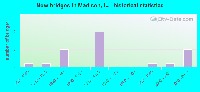
- New bridges - historical statistics
- 11920-1929
- 11930-1939
- 51940-1949
- 101960-1969
- 11990-1999
- 12000-2009
- 52010-2019

- Reconstructed bridges - Historical Statistics
- 11980-1989
- 51990-1999


- Bridge Condition - Deck
- 14.3%Very good
- 50.0%Good
- 7.1%Satisfactory
- 7.1%Fair
- 14.3%Poor
- 7.1%Serious

- Bridge Condition - Superstructure
- 28.6%Very good
- 35.7%Good
- 14.3%Satisfactory
- 7.1%Fair
- 7.1%Poor
- 7.1%Serious

- Bridge Condition - Substructure
- 35.7%Very good
- 42.9%Good
- 7.1%Satisfactory
- 14.3%Fair

- Bridge Condition - Channel
- 44.4%Very good
- 55.6%Good
Find on map >> Show street view
Structure Number: 600068, Location: 1.3 M E MISS R (Lat: 38.761653, Lng: -90.142247), Route carried "on" structure: Other road , Year Built: 1949, Year Reconstructed: 1999, Status: Posted for load, Structure Length: 72.18m (236.81ft), Average Daily Traffic: 525 (year 2021), Truck Traffic: 3%, Average Future Daily Traffic: 424 (year 2032), Design Load: H 20, Features Intersected: CHAIN OF ROCKS CANAL, Facility Carried by Structure: OLD CHAIN RKS RD/O
Minimum Vertical Clearance: 5.00m (16.40ft), Kilometerpoint: 2.929, Lanes on structure: 1, Lanes under structure: 6, Owner: City or Municipal Highway Agency, Approaching Roadway Width: 6.7m (22.0ft), Navigation Control: Yes ( Vertical Clearance: 15.2m (49.9ft), Horizontal Clearance: 117.0m (383.9ft)), Material/Design: Steel, Design/Construction: Truss - Thru, Number Of Spans In Main Unit: 17, Number Of Approach Spans: 2, Length of Maximum Span: 141.1m (462.9ft), Curb or Sidewalk Widths: Left: 2.4m (7.9ft), Right: 0.0m, Curb-To-Curb Width: 5.4m (17.7ft), Out-to-Out Width: 9.4m (30.8ft)
Condition: Deck: Good, Superstructure: Serious, Substructure: Satisfactory, Channel: Good, Operating Rating: 18.8 metric tons, Method Used To Determine Operating Rating: Load Factor (LF) rating reported by rating factor (RF) method using MS18 loading, Inventory Rating: 11.0 metric tons, Method Used To Determine Inventory Rating: Load Factor (LF) rating reported by rating factor (RF) method using MS18 loading, Structural Evaluation: High priority of corrective action, Deck Geometry: High priority of replacement, Underclear: High priority of corrective action, Waterway Adequacy: Equal to present desirable criteria, Approach Roadway Alignment: Equal to present minimum criteria, Bridge Posting: Required (Relationship of Operating Rating to Maximum Legal Load: 30.0 - 39.9% below), Length Of Structure Improvement: 72.18m (236.81ft), Designated Inspection Frequency: Every 24 months, Critical Feature Inspection Frequency: Every 12 months, Underwater Inspection Frequency: Every 60 months, Inspection Date: September 2021, Critical Feature Inspection Date: August 2021, Underwater Inspection Date: September 2016, Bridge Improvement Cost: $5,105,000, Roadway Improvement Cost: $511,000, Total Project Cost: $5,616,000, Deck Structure Type: Open Grating, Wearing Surface/Protective System: Deck Protection: Epoxy Coated Reinforcing
Find on map >> Show street view
Structure Number: 600125, Location: 1.1mi N of 55/70 (Lat: 38.674275, Lng: -90.078664), Route carried "on" structure: State highway 111, Year Built: 1941, Year Reconstructed: 1995, Status: Open, Structure Length: 11.23m (36.84ft), Average Daily Traffic: 4,100 (year 2021), Truck Traffic: 10%, Average Future Daily Traffic: 4,823 (year 2032), Design Load: HS 20, Features Intersected: HORSESHOE LK CHANNEL
Minimum Vertical Clearance: 30+ m (98+ ft), Kilometerpoint: 9.141, Lanes on structure: 2, Base Highway Network: Yes, Owner: State Highway Agency, Approaching Roadway Width: 12.2m (40.0ft), Skew: 4 degrees, Material/Design: Steel continuous, Design/Construction: Stringer/Multi-beam, Number Of Spans In Main Unit: 4, Length of Maximum Span: 30.8m (101.0ft), Curb-To-Curb Width: 12.2m (40.0ft), Out-to-Out Width: 13.1m (43.0ft)
Condition: Deck: Satisfactory, Superstructure: Good, Substructure: Good, Channel: Very good, Operating Rating: 80.4 metric tons, Method Used To Determine Operating Rating: Load Factor (LF) rating reported by rating factor (RF) method using MS18 loading, Inventory Rating: 40.5 metric tons, Method Used To Determine Inventory Rating: Load Factor (LF) rating reported by rating factor (RF) method using MS18 loading, Structural Evaluation: Better than present minimum criteria, Deck Geometry: Equal to present minimum criteria, Waterway Adequacy: Equal to present desirable criteria, Approach Roadway Alignment: Equal to present desirable criteria, Designated Inspection Frequency: Every 24 months, Underwater Inspection Frequency: Every 24 months, Inspection Date: April 2021, Underwater Inspection Date: October 2020, Deck Structure Type: Concrete Cast-file-Place, Wearing Surface/Protective System: Deck Protection: Epoxy Coated Reinforcing
Find on map >> Show street view
Structure Number: 600127, Location: 0.24 MI N I-55/70 (Lat: 38.665494, Lng: -90.090747), Route carried "on" structure: State highway 111, Year Built: 1961, Status: Open, Structure Length: 9.67m (31.73ft), Average Daily Traffic: 4,100 (year 2021), Truck Traffic: 10%, Average Future Daily Traffic: 2,412 (year 2032), Design Load: H 20, Features Intersected: CAHOKIA CANAL
Minimum Vertical Clearance: 30+ m (98+ ft), Kilometerpoint: 7.709, Lanes on structure: 2, Base Highway Network: Yes, Owner: State Highway Agency, Approaching Roadway Width: 10.4m (34.1ft), Skew: 6 degrees, Material/Design: Steel continuous, Design/Construction: Stringer/Multi-beam, Number Of Spans In Main Unit: 3, Length of Maximum Span: 37.0m (121.4ft), Curb or Sidewalk Widths: Left: 0.0m, Right: 1.2m (3.9ft), Curb-To-Curb Width: 9.1m (29.9ft), Out-to-Out Width: 11.1m (36.4ft)
Condition: Deck: Serious, Superstructure: Poor, Substructure: Fair, Channel: Good, Operating Rating: 63.2 metric tons, Method Used To Determine Operating Rating: Load Factor (LF) rating reported by rating factor (RF) method using MS18 loading, Inventory Rating: 37.9 metric tons, Method Used To Determine Inventory Rating: Load Factor (LF) rating reported by rating factor (RF) method using MS18 loading, Structural Evaluation: Meets minimum limits, Deck Geometry: Meets minimum limits, Waterway Adequacy: Equal to present desirable criteria, Approach Roadway Alignment: Equal to present desirable criteria, Designated Inspection Frequency: Every 12 months, Inspection Date: April 2021, Deck Structure Type: Concrete Cast-file-Place, Wearing Surface/Protective System: Wearing Surface: Bituminous
Find on map >> Show street view
Structure Number: 600244, Location: .5MI N JCT 70 (Lat: 38.665892, Lng: -90.090203), Route carried "on" structure: State highway 111, Year Built: 2002, Status: Open, Structure Length: 11.26m (36.94ft), Average Daily Traffic: 4,100 (year 2021), Truck Traffic: 10%, Average Future Daily Traffic: 2,412 (year 2032), Design Load: HS 20, Features Intersected: CAHOKIA CANAL
Minimum Vertical Clearance: 30+ m (98+ ft), Kilometerpoint: 7.773, Lanes on structure: 2, Base Highway Network: Yes, Owner: State Highway Agency, Approaching Roadway Width: 11.0m (36.1ft), Skew: 6 degrees, Material/Design: Steel continuous, Design/Construction: Stringer/Multi-beam, Number Of Spans In Main Unit: 3, Length of Maximum Span: 37.0m (121.4ft), Curb-To-Curb Width: 11.0m (36.1ft), Out-to-Out Width: 11.9m (39.0ft)
Condition: Deck: Good, Superstructure: Very good, Substructure: Very good, Channel: Very good, Operating Rating: 75.8 metric tons, Method Used To Determine Operating Rating: Load Factor (LF) rating reported by rating factor (RF) method using MS18 loading, Inventory Rating: 45.4 metric tons, Method Used To Determine Inventory Rating: Load Factor (LF) rating reported by rating factor (RF) method using MS18 loading, Structural Evaluation: Equal to present desirable criteria, Deck Geometry: Equal to present minimum criteria, Waterway Adequacy: Equal to present desirable criteria, Approach Roadway Alignment: Equal to present desirable criteria, Designated Inspection Frequency: Every 24 months, Inspection Date: April 2021, Deck Structure Type: Concrete Cast-file-Place, Wearing Surface/Protective System: Deck Protection: Epoxy Coated Reinforcing
Find on map >> Show street view
Structure Number: 600265, Location: .2M S MADISON CL (Lat: 38.675472, Lng: -90.147431), Route carried "on" structure: State highway 203, Year Built: 1992, Status: Open, Structure Length: 2.54m (8.33ft), Average Daily Traffic: 13,000 (year 2021), Truck Traffic: 9%, Average Future Daily Traffic: 14,416 (year 2032), Design Load: HS 20, Features Intersected: UP, NS RR/Service Rd
Minimum Vertical Clearance: 30+ m (98+ ft), Kilometerpoint: 4.232, Lanes on structure: 4, Base Highway Network: Yes, Owner: State Highway Agency, Approaching Roadway Width: 15.8m (51.8ft), Skew: 2 degrees, Material/Design: Steel, Design/Construction: Stringer/Multi-beam, Number Of Spans In Main Unit: 1, Length of Maximum Span: 24.7m (81.0ft), Curb or Sidewalk Widths: Left: 1.5m (4.9ft), Right: 0.0m, Curb-To-Curb Width: 15.8m (51.8ft), Out-to-Out Width: 18.2m (59.7ft)
Condition: Deck: Good, Superstructure: Good, Substructure: Good, Operating Rating: 82.3 metric tons, Method Used To Determine Operating Rating: Load Factor (LF) rating reported by rating factor (RF) method using MS18 loading, Inventory Rating: 49.2 metric tons, Method Used To Determine Inventory Rating: Load Factor (LF) rating reported by rating factor (RF) method using MS18 loading, Structural Evaluation: Better than present minimum criteria, Deck Geometry: Meets minimum limits, Underclear: Superior to present desirable criteria, Approach Roadway Alignment: Equal to present desirable criteria, Designated Inspection Frequency: Every 48 months, Inspection Date: January 2022, Deck Structure Type: Concrete Cast-file-Place, Wearing Surface/Protective System: Deck Protection: Epoxy Coated Reinforcing
Find on map >> Show street view
Structure Number: 600345, Location: 2 MI E MISSISSIPPI R (Lat: 38.765642, Lng: -90.138478), Route carried "on" structure: Interstate 270, Year Built: 2014, Status: Open, Structure Length: 60.37m (198.06ft), Average Daily Traffic: 49,200 (year 2021), Truck Traffic: 18%, Average Future Daily Traffic: 66,700 (year 2032), Design Load: HS 25 or greater, Features Intersected: CHAIN OF ROCKS CANAL
Minimum Vertical Clearance: 30+ m (98+ ft), Kilometerpoint: 2.897, Lanes on structure: 4, Base Highway Network: Yes, Owner: State Highway Agency, Approaching Roadway Width: 26.8m (87.9ft), Skew: 30 degrees, Navigation Control: Yes ( Vertical Clearance: 14.9m (48.9ft), Horizontal Clearance: 106.7m (350.1ft)), Material/Design: Steel continuous, Design/Construction: Stringer/Multi-beam, Number Of Spans In Main Unit: 5, Length of Maximum Span: 149.4m (490.2ft), Curb-To-Curb Width: 26.8m (87.9ft), Out-to-Out Width: 28.7m (94.2ft)
Condition: Deck: Very good, Superstructure: Very good, Substructure: Very good, Channel: Very good, Operating Rating: 77.8 metric tons, Method Used To Determine Operating Rating: Load and Resistance Factor Rating (LRFR) rating reported by rating factor(RF) method using HL-93 loadings, Inventory Rating: 60.3 metric tons, Method Used To Determine Inventory Rating: Load and Resistance Factor Rating (LRFR) rating reported by rating factor(RF) method using HL-93 loadings, Structural Evaluation: Equal to present desirable criteria, Deck Geometry: Superior to present desirable criteria, Waterway Adequacy: Equal to present desirable criteria, Approach Roadway Alignment: Equal to present desirable criteria, Designated Inspection Frequency: Every 24 months, Underwater Inspection Frequency: Every 60 months, Inspection Date: June 2020, Underwater Inspection Date: June 2020, Deck Structure Type: Concrete Cast-file-Place, Wearing Surface/Protective System: Deck Protection: Epoxy Coated Reinforcing
Find on map >> Show street view
Structure Number: 602013, Location: 1.13 E OF MISS RIVER (Lat: 38.762619, Lng: -90.150278), Route carried "on" structure: Interstate 270, Year Built: 1964, Status: Open, Structure Length: 0.86m (2.82ft), Average Daily Traffic: 49,200 (year 2021), Truck Traffic: 18%, Average Future Daily Traffic: 57,240 (year 2032), Design Load: HS 20+Mod, Features Intersected: WATER MAIN
Minimum Vertical Clearance: 30+ m (98+ ft), Kilometerpoint: 1.883, Lanes on structure: 4, Base Highway Network: Yes, Owner: State Highway Agency, Approaching Roadway Width: 12.8m (42.0ft), Skew: 3 degrees, Material/Design: Concrete, Design/Construction: Culvert, Number Of Spans In Main Unit: 1, Length of Maximum Span: 8.2m (26.9ft)
Condition: Culverts: Very good, Operating Rating: 97.2 metric tons, Method Used To Determine Operating Rating: Load Factor (LF) rating reported by rating factor (RF) method using MS18 loading, Inventory Rating: 97.2 metric tons, Method Used To Determine Inventory Rating: Load Factor (LF) rating reported by rating factor (RF) method using MS18 loading, Structural Evaluation: Equal to present desirable criteria, Approach Roadway Alignment: Equal to present desirable criteria, Designated Inspection Frequency: Every 24 months, Inspection Date: January 2022
Find on map >> Show street view
Structure Number: 820019, Location: 1/2 Mi E of E St Lou (Lat: 38.642644, Lng: -90.131742), Route carried "on" structure: Interstate 55, Year Built: 1960, Status: Open, Structure Length: 3.90m (12.80ft), Average Daily Traffic: 33,650 (year 2021), Truck Traffic: 16%, Average Future Daily Traffic: 30,805 (year 2032), Design Load: HS 20+Mod, Features Intersected: DRAINAGE CANAL
Minimum Vertical Clearance: 30+ m (98+ ft), Kilometerpoint: 6.019, Lanes on structure: 3, Base Highway Network: Yes, Owner: State Highway Agency, Approaching Roadway Width: 15.5m (50.9ft), Skew: 4 degrees, Material/Design: Steel continuous, Design/Construction: Stringer/Multi-beam, Number Of Spans In Main Unit: 3, Length of Maximum Span: 13.4m (44.0ft), Curb-To-Curb Width: 15.6m (51.2ft), Out-to-Out Width: 17.1m (56.1ft)
Condition: Deck: Fair, Superstructure: Good, Substructure: Good, Channel: Very good, Operating Rating: 61.6 metric tons, Method Used To Determine Operating Rating: Load Factor (LF) rating reported by rating factor (RF) method using MS18 loading, Inventory Rating: 33.4 metric tons, Method Used To Determine Inventory Rating: Load Factor (LF) rating reported by rating factor (RF) method using MS18 loading, Structural Evaluation: Better than present minimum criteria, Deck Geometry: Somewhat better than minimum adequacy, Waterway Adequacy: Superior to present desirable criteria, Approach Roadway Alignment: Equal to present desirable criteria, Designated Inspection Frequency: Every 24 months, Inspection Date: September 2021, Deck Structure Type: Concrete Cast-file-Place, Wearing Surface/Protective System: Wearing Surface: Other
Find on map >> Show street view
Structure Number: 820022, Location: S of Gateway Racetrk (Lat: 38.642706, Lng: -90.132414), Route carried "on" structure: Other road , Year Built: 1960, Year Reconstructed: 1989, Status: Open, Structure Length: 2.90m (9.51ft), Average Daily Traffic: 7,600 (year 2018), Truck Traffic: 16%, Average Future Daily Traffic: 9,414 (year 2032), Design Load: HS 20, Features Intersected: DRNG TO CAHOKIA CNL, Facility Carried by Structure: 203SB RMP TO 55/70
Minimum Vertical Clearance: 30+ m (98+ ft), Kilometerpoint: 0.692, Lanes on structure: 2, Base Highway Network: Yes (Inventory Route: 10070040, Subroute: 40), Owner: State Highway Agency, Approaching Roadway Width: 10.7m (35.1ft), Material/Design: Steel continuous, Design/Construction: Stringer/Multi-beam, Number Of Spans In Main Unit: 3, Length of Maximum Span: 10.4m (34.1ft), Curb-To-Curb Width: 9.1m (29.9ft), Out-to-Out Width: 10.9m (35.8ft)
Condition: Deck: Poor, Superstructure: Satisfactory, Substructure: Fair, Channel: Good, Operating Rating: 53.5 metric tons, Method Used To Determine Operating Rating: Load Factor (LF) rating reported by rating factor (RF) method using MS18 loading, Inventory Rating: 32.1 metric tons, Method Used To Determine Inventory Rating: Load Factor (LF) rating reported by rating factor (RF) method using MS18 loading, Structural Evaluation: Somewhat better than minimum adequacy, Deck Geometry: High priority of replacement, Waterway Adequacy: Equal to present desirable criteria, Approach Roadway Alignment: Equal to present desirable criteria, Designated Inspection Frequency: Every 24 months, Inspection Date: January 2022, Deck Structure Type: Concrete Cast-file-Place, Wearing Surface/Protective System: Wearing Surface: Other
Find on map >> Show street view
Structure Number: 820025, Location: 0.6 M E E ST LOUIS (Lat: 38.647497, Lng: -90.131569), Route carried "on" structure: Other road , Year Built: 1960, Year Reconstructed: 1999, Status: Open, Structure Length: 6.64m (21.78ft), Average Daily Traffic: 7,600 (year 2018), Truck Traffic: 14%, Average Future Daily Traffic: 10,251 (year 2032), Design Load: HS 20, Features Intersected: SB RAMP TO EB 55/70, Facility Carried by Structure: ILL 203 NB
Minimum Vertical Clearance: 30+ m (98+ ft), Kilometerpoint: 0.933, Lanes on structure: 2, Lanes under structure: 2, Base Highway Network: Yes (Inventory Route: 10070040, Subroute: 20), Owner: State Highway Agency, Approaching Roadway Width: 13.4m (44.0ft), Skew: 5 degrees, Material/Design: Steel continuous, Design/Construction: Stringer/Multi-beam, Number Of Spans In Main Unit: 3, Length of Maximum Span: 22.3m (73.2ft), Curb-To-Curb Width: 9.1m (29.9ft), Out-to-Out Width: 10.7m (35.1ft)
Condition: Deck: Good, Superstructure: Good, Substructure: Good, Operating Rating: 71.6 metric tons, Method Used To Determine Operating Rating: Load Factor (LF) rating reported by rating factor (RF) method using MS18 loading, Inventory Rating: 43.1 metric tons, Method Used To Determine Inventory Rating: Load Factor (LF) rating reported by rating factor (RF) method using MS18 loading, Structural Evaluation: Better than present minimum criteria, Deck Geometry: Meets minimum limits, Underclear: Meets minimum limits, Approach Roadway Alignment: Equal to present desirable criteria, Length Of Structure Improvement: 6.64m (21.78ft), Designated Inspection Frequency: Every 24 months, Inspection Date: January 2022, Bridge Improvement Cost: $536,000, Roadway Improvement Cost: $54,000, Total Project Cost: $590,000, Deck Structure Type: Concrete Cast-file-Place, Wearing Surface/Protective System: Deck Protection: Epoxy Coated Reinforcing
Find on map >> Show street view
Structure Number: 820027, Location: 0.8 M N E ST LOUIS (Lat: 38.656789, Lng: -90.135036), Route carried "on" structure: State highway 203, Year Built: 1960, Status: Open, Structure Length: 5.70m (18.70ft), Average Daily Traffic: 13,400 (year 2021), Truck Traffic: 10%, Average Future Daily Traffic: 7,897 (year 2032), Design Load: HS 20, Features Intersected: CAHOKIA CANAL
Minimum Vertical Clearance: 30+ m (98+ ft), Kilometerpoint: 1.819, Lanes on structure: 2, Base Highway Network: Yes, Owner: State Highway Agency, Approaching Roadway Width: 10.7m (35.1ft), Skew: 1 degrees, Material/Design: Steel continuous, Design/Construction: Stringer/Multi-beam, Number Of Spans In Main Unit: 3, Length of Maximum Span: 20.4m (66.9ft), Curb or Sidewalk Widths: Left: 0.6m (2.0ft), Right: 0.6m (2.0ft), Curb-To-Curb Width: 9.1m (29.9ft), Out-to-Out Width: 11.2m (36.7ft)
Condition: Deck: Poor, Superstructure: Fair, Substructure: Good, Channel: Good, Operating Rating: 66.4 metric tons, Method Used To Determine Operating Rating: Load Factor (LF) rating reported by rating factor (RF) method using MS18 loading, Inventory Rating: 35.6 metric tons, Method Used To Determine Inventory Rating: Load Factor (LF) rating reported by rating factor (RF) method using MS18 loading, Structural Evaluation: Somewhat better than minimum adequacy, Deck Geometry: Meets minimum limits, Waterway Adequacy: Equal to present desirable criteria, Approach Roadway Alignment: Equal to present desirable criteria, Designated Inspection Frequency: Every 24 months, Inspection Date: January 2022, Deck Structure Type: Concrete Cast-file-Place, Wearing Surface/Protective System: Wearing Surface: Other
Find on map >> Show street view
Structure Number: 820028, Location: 0.5 M N E ST LOUIS (Lat: 38.645153, Lng: -90.128433), Route carried "on" structure: State highway 203, Year Built: 1960, Year Reconstructed: 1999, Status: Open, Structure Length: 8.60m (28.22ft), Average Future Daily Traffic: 19,142 (year 2032), Design Load: HS 20, Features Intersected: FAI 70
Minimum Vertical Clearance: 30+ m (98+ ft), Kilometerpoint: 0.451, Lanes on structure: 4, Lanes under structure: 8, Base Highway Network: Yes, Owner: State Highway Agency, Approaching Roadway Width: 21.9m (71.9ft), Skew: 30 degrees, Material/Design: Steel continuous, Design/Construction: Stringer/Multi-beam, Number Of Spans In Main Unit: 4, Length of Maximum Span: 26.5m (86.9ft), Curb-To-Curb Width: 16.5m (54.1ft), Out-to-Out Width: 19.4m (63.6ft)
Condition: Deck: Good, Superstructure: Good, Substructure: Good, Operating Rating: 77.1 metric tons, Method Used To Determine Operating Rating: Load Factor (LF) rating reported by rating factor (RF) method using MS18 loading, Inventory Rating: 46.3 metric tons, Method Used To Determine Inventory Rating: Load Factor (LF) rating reported by rating factor (RF) method using MS18 loading, Structural Evaluation: Better than present minimum criteria, Deck Geometry: Meets minimum limits, Underclear: High priority of corrective action, Approach Roadway Alignment: Equal to present desirable criteria, Length Of Structure Improvement: 8.60m (28.22ft), Designated Inspection Frequency: Every 24 months, Inspection Date: January 2022, Bridge Improvement Cost: $1,255,000, Roadway Improvement Cost: $126,000, Total Project Cost: $1,381,000, Deck Structure Type: Concrete Cast-file-Place, Wearing Surface/Protective System: Deck Protection: Epoxy Coated Reinforcing
Find on map >> Show street view
Structure Number: 820113, Location: E ILL 203 S BEND RD (Lat: 38.657831, Lng: -90.130303), Route carried "on" structure: City street , Year Built: 1923, Year Reconstructed: 1997, Status: Open, Structure Length: 4.13m (13.55ft), Average Daily Traffic: 1,100 (year 2018), Truck Traffic: 56%, Average Future Daily Traffic: 4,027 (year 2032), Design Load: HS 20, Features Intersected: CAHOKIA CANAL, Facility Carried by Structure: SBI-4
Minimum Vertical Clearance: 30+ m (98+ ft), Kilometerpoint: 0.306, Lanes on structure: 2, Owner: City or Municipal Highway Agency, Approaching Roadway Width: 7.3m (24.0ft), Material/Design: Prestressed concrete, Design/Construction: Box Beam or Girders - Multiple, Number Of Spans In Main Unit: 3, Length of Maximum Span: 13.3m (43.6ft), Curb or Sidewalk Widths: Left: 1.5m (4.9ft), Right: 0.0m, Curb-To-Curb Width: 9.1m (29.9ft), Out-to-Out Width: 10.7m (35.1ft)
Condition: Deck: Very good, Superstructure: Satisfactory, Substructure: Very good, Channel: Good, Operating Rating: 58.0 metric tons, Method Used To Determine Operating Rating: Load Factor (LF) rating reported by rating factor (RF) method using MS18 loading, Inventory Rating: 34.7 metric tons, Method Used To Determine Inventory Rating: Load Factor (LF) rating reported by rating factor (RF) method using MS18 loading, Structural Evaluation: Equal to present minimum criteria, Deck Geometry: Somewhat better than minimum adequacy, Waterway Adequacy: Equal to present desirable criteria, Approach Roadway Alignment: Equal to present minimum criteria, Designated Inspection Frequency: Every 24 months, Inspection Date: November 2019, Deck Structure Type: Concrete Precast Panels, Wearing Surface/Protective System: Wearing Surface: Bituminous, Deck Protection: Other Coated Reinforcing
Find on map >> Show street view
Structure Number: 820318, Location: 1.4 mi N of I-55/64 (Lat: 38.648714, Lng: -90.161269), Route carried "on" structure: Interstate 70, Year Built: 2013, Status: Open, Structure Length: 38.67m (126.87ft), Average Daily Traffic: 22,150 (year 2019), Truck Traffic: 14%, Average Future Daily Traffic: 17,762 (year 2037), Design Load: HS 25 or greater, Features Intersected: INDUSTRIAL DR & RR'S
Minimum Vertical Clearance: 30+ m (98+ ft), Kilometerpoint: 1.577, Lanes on structure: 2, Lanes under structure: 2, Base Highway Network: Yes, Owner: State Highway Agency, Approaching Roadway Width: 12.2m (40.0ft), Material/Design: Steel continuous, Design/Construction: Stringer/Multi-beam, Number Of Spans In Main Unit: 5, Length of Maximum Span: 87.3m (286.4ft), Curb-To-Curb Width: 12.2m (40.0ft), Out-to-Out Width: 13.0m (42.7ft)
Condition: Deck: Good, Superstructure: Very good, Substructure: Very good, Operating Rating: 48.0 metric tons, Method Used To Determine Operating Rating: Load and Resistance Factor Rating (LRFR) rating reported by rating factor(RF) method using HL-93 loadings, Inventory Rating: 36.9 metric tons, Method Used To Determine Inventory Rating: Load and Resistance Factor Rating (LRFR) rating reported by rating factor(RF) method using HL-93 loadings, Structural Evaluation: Equal to present desirable criteria, Deck Geometry: Better than present minimum criteria, Approach Roadway Alignment: Equal to present desirable criteria, Designated Inspection Frequency: Every 24 months, Inspection Date: May 2021, Deck Structure Type: Concrete Cast-file-Place, Wearing Surface/Protective System: Deck Protection: Epoxy Coated Reinforcing
Find on map >> Show street view
Structure Number: 820319, Location: 1.4 mi N of I-55/64 (Lat: 38.648714, Lng: -90.161269), Route carried "on" structure: Interstate 70, Year Built: 2013, Status: Open, Structure Length: 39.60m (129.92ft), Average Daily Traffic: 22,150 (year 2019), Truck Traffic: 14%, Average Future Daily Traffic: 17,762 (year 2037), Design Load: HS 25 or greater, Features Intersected: INDUSTRIAL DR & RR'S
Minimum Vertical Clearance: 30+ m (98+ ft), Kilometerpoint: 1.577, Lanes on structure: 2, Lanes under structure: 2, Base Highway Network: Yes, Owner: State Highway Agency, Approaching Roadway Width: 12.2m (40.0ft), Material/Design: Steel continuous, Design/Construction: Stringer/Multi-beam, Number Of Spans In Main Unit: 5, Length of Maximum Span: 87.3m (286.4ft), Curb-To-Curb Width: 12.2m (40.0ft), Out-to-Out Width: 13.0m (42.7ft)
Condition: Deck: Good, Superstructure: Very good, Substructure: Very good, Operating Rating: 58.3 metric tons, Method Used To Determine Operating Rating: Load and Resistance Factor Rating (LRFR) rating reported by rating factor(RF) method using HL-93 loadings, Inventory Rating: 45.0 metric tons, Method Used To Determine Inventory Rating: Load and Resistance Factor Rating (LRFR) rating reported by rating factor(RF) method using HL-93 loadings, Structural Evaluation: Equal to present desirable criteria, Deck Geometry: Better than present minimum criteria, Approach Roadway Alignment: Equal to present desirable criteria, Designated Inspection Frequency: Every 24 months, Inspection Date: May 2021, Deck Structure Type: Concrete Cast-file-Place, Wearing Surface/Protective System: Deck Protection: Epoxy Coated Reinforcing
Find on map >> Show street view
Structure Number: 600068, Location: 1.3 M E MISS R (Lat: 38.761739, Lng: -90.139961), Route carried "under" structure: City street , Year Built: 1949, Structure Length: 0. m, Average Daily Traffic: 25 (year 2021), Truck Traffic: 8%, Features Intersected: CHAIN OF ROCKS CANAL, Facility Carried by Structure: OLD CHAIN RKS RD/O
Minimum Vertical Clearance: 3.99m (13.09ft), Kilometerpoint: 2.044, Lanes on structure: 1, Lanes under structure: 2, Material/Design: Steel, Design/Construction: Truss - Thru, Length of Maximum Span: 141.1m (462.9ft)
Find on map >> Show street view
Structure Number: 600068, Location: 1.3 M E MISS R (Lat: 38.761919, Lng: -90.135519), Route carried "under" structure: Other road , Year Built: 1949, Structure Length: 0. m, Average Daily Traffic: 50 (year 2021), Truck Traffic: 16%, Features Intersected: CHAIN OF ROCKS CANAL, Facility Carried by Structure: OLD CHAIN RKS RD/O
Minimum Vertical Clearance: 3.86m (12.66ft), Kilometerpoint: 5.713, Lanes on structure: 1, Lanes under structure: 2, Material/Design: Steel, Design/Construction: Truss - Thru, Length of Maximum Span: 141.1m (462.9ft)
Find on map >> Show street view
Structure Number: 600068, Location: 1.3 M E MISS R (Lat: 38.761961, Lng: -90.134892), Route carried "under" structure: City street , Year Built: 1949, Structure Length: 0. m, Average Daily Traffic: 275 (year 2021), Truck Traffic: 12%, Features Intersected: CHAIN OF ROCKS CANAL, Facility Carried by Structure: OLD CHAIN RKS RD/O
Minimum Vertical Clearance: 11.58m (37.99ft), Kilometerpoint: 0.499, Lanes on structure: 1, Lanes under structure: 2, Material/Design: Steel, Design/Construction: Truss - Thru, Length of Maximum Span: 141.1m (462.9ft)
Find on map >> Show street view
Structure Number: 609902, Location: SO OF MADISON (Lat: 38.668686, Lng: -90.144586), Route carried "under" structure: State highway 203, Year Built: 1935, Structure Length: 0. m, Average Daily Traffic: 12,900 (year 2021), Truck Traffic: 10%, Features Intersected: FAP594/IL203, Facility Carried by Structure: ITRR
Minimum Vertical Clearance: 4.27m (14.01ft), Kilometerpoint: 3.444, Lanes under structure: 4, Material/Design: Steel, Design/Construction: Girder and Floorbeam System, Length of Maximum Span: 16.2m (53.1ft)
Find on map >> Show street view
Structure Number: 820024, Location: 0.4 M E E ST LOUIS (Lat: 38.643611, Lng: -90.130600), Route carried "under" structure: Interstate 55, Year Built: 1960, Structure Length: 0. m, Average Daily Traffic: 67,300 (year 2021), Truck Traffic: 16%, Features Intersected: DRNG CANAL & I-55/70, Facility Carried by Structure: RAMP TO IL 203 NB
Minimum Vertical Clearance: 5.08m (16.67ft), Kilometerpoint: 6.148, Lanes on structure: 2, Lanes under structure: 8, Material/Design: Steel continuous, Design/Construction: Stringer/Multi-beam, Length of Maximum Span: 29.6m (97.1ft)
Find on map >> Show street view
Structure Number: 820025, Location: 0.6 M E E ST LOUIS (Lat: 38.647900, Lng: -90.131789), Route carried "under" structure: State highway 203, Year Built: 1960, Structure Length: 0. m, Average Daily Traffic: 14,600 (year 2021), Truck Traffic: 15%, Features Intersected: SB RAMP TO EB 55/70
Minimum Vertical Clearance: 4.62m (15.16ft), Kilometerpoint: 0.805, Lanes on structure: 2, Lanes under structure: 2, Material/Design: Steel continuous, Design/Construction: Stringer/Multi-beam, Length of Maximum Span: 22.3m (73.2ft)
Find on map >> Show street view
Structure Number: 820028, Location: 0.5 M N E ST LOUIS (Lat: 38.645153, Lng: -90.128433), Route carried "under" structure: Interstate 55, Year Built: 1960, Structure Length: 0. m, Average Daily Traffic: 54,000 (year 2021), Truck Traffic: 17%, Features Intersected: FAI 70, Facility Carried by Structure: ILL 203
Minimum Vertical Clearance: 5.11m (16.77ft), Kilometerpoint: 6.389, Lanes on structure: 4, Lanes under structure: 8, Material/Design: Steel continuous, Design/Construction: Stringer/Multi-beam, Length of Maximum Span: 26.5m (86.9ft)
Find on map >> Show street view
Structure Number: 820318, Location: 1.4 mi N of I-55/64 (Lat: 38.648714, Lng: -90.161269), Route carried "under" structure: City street , Year Built: 2013, Structure Length: 0. m, Average Daily Traffic: 200 (year 2018), Features Intersected: INDUSTRIAL DR & RR'S, Facility Carried by Structure: RELOCATED I-70 EB
Minimum Vertical Clearance: 6.38m (20.93ft), Kilometerpoint: 0.257, Lanes on structure: 2, Lanes under structure: 2, Material/Design: Steel continuous, Design/Construction: Stringer/Multi-beam, Length of Maximum Span: 87.3m (286.4ft)
Find on map >> Show street view
Structure Number: 820319, Location: 1.4 mi N of I-55/64 (Lat: 38.648714, Lng: -90.161269), Route carried "under" structure: City street , Year Built: 2013, Structure Length: 0. m, Average Daily Traffic: 200 (year 2018), Features Intersected: INDUSTRIAL DR & RR'S, Facility Carried by Structure: RELOCATED I-70 WB
Minimum Vertical Clearance: 6.53m (21.42ft), Kilometerpoint: 0.257, Lanes on structure: 2, Lanes under structure: 2, Material/Design: Steel continuous, Design/Construction: Stringer/Multi-beam, Length of Maximum Span: 87.3m (286.4ft)